Caucasian mineral water mountains. Rest and treatment in CMS: tourist information and tips
As one of the most worthy and great Russian writers and poets would say: "Whoever did not breathe the mountainous Caucasian air - he did not live ..".
In this article we will talk about the Caucasian Mineral Waters. What is good about this Caucasian resort and what is unique about Min. waters.
The Caucasus is not just mountains, gorgeous nature, springs, springs, eagles over gorges, vipers on mountain roads between placers of rhododendrons, the Caucasus is a special spirit, a special culture, this can not be found anywhere else, a harsh, wild, proud, very beautiful, sometimes virgin region.
Caucasian Mineralnye Vody is a group of resorts of federal significance in the Stavropol Territory, a specially protected ecological resort region Russian Federation.
South of the European part of Russia. The resort includes the cities and territories:
“The region-agglomeration Caucasian Mineralnye Vody, having an area of more than 500 thousand hectares (5.3 thousand sq. km), is located on the territory of three constituent entities of the Russian Federation within the boundaries of the district of the mountain and sanitary protection:
in the Stavropol Territory - the cities and resort towns of Georgievsk, Mineralnye Vody (including the resort of Kumagorsk and the resort area of Naguta), Pyatigorsk, Zheleznovodsk, Lermontov, Essentuki, Kislovodsk, as well as the districts of Georgievsky, Mineralovodsky and Predgorny, - 58% of the total area of the region;
in Kabardino-Balkaria - Zolsky district - 9% (therapeutic mud of Lake Tambukan, Narzanov Valley and others);
in Karachay-Cherkessia - Malokarachaevsky and Prikubansky districts, - 33% of the territory (zone of formation mineral springs)».
The location of the resort is, to put it mildly, chic:
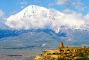
"The region of the Caucasian Mineral Waters occupies southern part Stavropol Territory and is located on the northern slopes of the Main Caucasian Range, just a couple of tens of kilometers from Elbrus. Here the earth seems different, the sky seems different.
From afar, motionless white clouds are visible, which, when approached, turn out to be the snowy peaks of the Caucasus Mountains. The southern borders of the region are the foothills of Elbrus, the valley of the Khasaut and Malka rivers; in the west - the upper reaches of the Eshkakon and Podkumka rivers; The northern border of the region is the city of Mineralnye Vody, beyond which the steppe expanses of Ciscaucasia begin.
Very close to the Stavropol Territory famous resorts Krasnodar Territory, Sochi:
“In the west and southwest, the Stavropol Territory borders on Krasnodar Territory, in the northwest with the Rostov region, in the north and northeast with Kalmykia, in the east with Dagestan, in the southeast with the Chechen Republic, in the south with North Ossetia-Alania, the Karachay-Cherkess and Kabardino-Balkarian republics.
About the resorts of Caucasian Mineralnye Vody in the video:
There are many sources of mineral waters in the Caucasian Mineral Waters, because it is not easy for the region to be named that way. The name of the main city - Essentuki - is listed on the bottles of medicinal water, which has been known to everyone for a couple of decades.
And the water really has healing properties, unlike the products with which the store shelves are crammed.
In addition, there are many springs, waterfalls, salt and mud springs in the region.
The resort has existed since the beginning of the 18th century, more precisely, the first mention of it dates back to this time. All forces were directed to the arrangement of the region, so in the 20th century the resort became the largest in Russia, and the most healing.
Most famous cities and resorts of Caucasian Mineralnye Vody:
Kumagorsk
Nagutsk
Zheleznovodsk
Pyatigorsk
Essentuki
Kislovodsk
Kislovodsk most mountain resort, it is located at an altitude of 817-1063 m above sea level, the lowest mountain point of Kislovodsk is 750 m above sea level, and the highest is 1409 m (on the Big Saddle in Kislovodsk Park).
“Kislovodsk is located in the south of the Stavropol Territory, practically on the border with Karachay-Cherkessia and Kabardino-Balkaria, 65 km from Mount Elbrus.
The city is located in a small and cozy picturesque valley, surrounded by the slopes of the Main Caucasian Range and formed by the gorges of two merging rivers - Olkhovka and Berezovka, flowing into the Podkumok River. The length of the valley from southeast to northwest is about 7 km.
The weather here is almost always good:“The climate of the KavMinVod region has long been highly appreciated by balneologists and is successfully used as a healing factor. The main advantages of the local climate are associated with a large number of sunny days - in Kislovodsk there are only 37-40 days a year without sun.
It is relatively dry here, moist air masses from the Black Sea do not reach here - they are delayed by the Main Caucasian Range.
« In terms of the number of sunny days, Kislovodsk is not inferior to the best resorts peace. On average, per year, the number of clear days in Kislovodsk is about 150, while in Pyatigorsk - 98, in Zheleznovodsk - 112, and in Essentuki - 117. cloudy days also small - an average of 61 days per year.
The air in Kislovodsk is always clean, mostly dry and invigorating. Kislovodsk stands out among other resorts of KavMinVodsk with its mostly quiet weather without strong winds and low humidity in winter, which fluctuates from 56 to 70% during the day, which has a beneficial effect on the well-being of holidaymakers.
In January, it was 18 degrees Celsius, minus temperatures reached 20 degrees, but much more often the temperature at this time of the year is around zero or “light minus”. The hottest months are July, August, the temperature, depending on the location near or in the distance of mountains, snowy gorges, from 4-5 degrees Celsius to 37 degrees of heat.
All the resorts of the Caucasian Mineral Waters are primarily medicinal, but Kislovodsk, Essentuki, Zheleznovodsk are special. After Sochi, Kislovodsk is the second city in terms of the number of health resorts and sanatoriums.
A third of all medical and preventive institutions in the region are located here. In Kislovodsk there is a source of the famous sour mineral water - Narzan.
Built on the site of a former fortress, the city is now replete with green spaces and orchards, in terms of numbers it is a very small town: 130 thousand people.
Most health resorts in Kislovodsk have a medical profile for the prevention of cardiovascular diseases, nervous diseases and respiratory organs.
In addition to health resorts, mineral springs and other beauties of the city, one of the most striking sights is the Kurortny Park, its area is 948 hectares, which is comparable to the huge city parks in Europe and the world.
“The park is located on both sides of the Olkhovka River and contains over 250 species of trees and shrubs, including cedar, fir, birch, pine, spruce, black walnut, Chinese paulownia, cork tree, etc. In the highland part of the park, more than 800 species of herbaceous plants.
There are ornamental plant nurseries and greenhouses in the park. More than 80 varieties of profusely blooming roses have been planted at the "Platform of Roses" and in the "Valley of Roses". Squirrels have acclimatized in the park, trustingly taking food from the hands of people, various species of birds.
The monument of nature is the Red Stones, which emerge in several places in the park and are sandstones with a red-brown color and various forms of weathering.
The park has a route for therapeutic walking - health path. And in Kislovodsk itself, there are several dozen large and popular sanatoriums.
Despite the fact that resorts and cities are located close to each other, the atmosphere in them is quite different. So, in Zheleznovodsk there is a different air, a slightly different climate - compared to other resorts of the Caucasian Mineral Waters.
Zheleznovodsk - the most dynamically developing resort of Kavminvod. In 2003 he was awarded the title of " Best City Russia" among small towns.
The climate here is mountain-forest, similar to the climate of the Middle Alps. Long-term meteorological observations made it possible to attribute it to the mountain-forest mid-mountain alpine, moderately dry.
The air is saturated with oxygen and phytoncides of the forest. Moderately hot summers with cool nights, a large number of sunny days with weak refreshing winds, winters are not cold.
The population of Zheleznovodsk is only about 25 thousand people, but despite the small number of inhabitants, the city is truly a pearl not only among the resorts of the Stavropol Territory, but throughout Russia.
Yes, there are few residents, but there are many more guests: for example, health resorts (about two dozen sanatoriums) in Zheleznovodsk can accommodate up to 80 thousand tourists. The direction of treatment is mainly diseases of the digestive system, kidneys, metabolic disorders.
Over 20 mineral water springs and several mud springs.
Pyatigorsk more, so to speak, "struck by industrialization" than the small towns and remote cities of Stavropol. In Pyatigorsk there are about 145 thousand inhabitants, industry, trade, and the scientific sphere are well developed.
“In the city there are Mount Mashuk (993.7 m, with a 112-meter TV relay tower installed on it) and its spurs.
The climate in Pyatigorsk is characterized by mild winters and hot summers. Due to the large amount of water resources and mild climate, the city has picturesque reservoirs, forest belts and parks.
The resort area, rich in underground mineral water sources, is relatively poor in surface water resources.
The tourist infrastructure of the resort city of Pyatigorsk includes:
More than 30 health resorts and sanatoriums. Every year they are visited by over 200 thousand people a year (225-250 thousand people a year in 16 sanatoriums and 7 boarding houses - in the second half - the end of the 80s);
43 travel companies and organizations;
17 hotels;
The city and Pyatigorye have a colossal tourism potential and have the right to compete with leading European resorts and balneological health resorts.”
In Pyatigorsk there are many museums, theaters, historical monuments, libraries, beautiful places. The city has parks and fountains.
“The surrounding mountains are adorned with natural forests, in which mighty oaks and snow-white birches, honey-bearing maples and lindens grow, and in autumn, dogwood, hawthorn, wild rose, barberry, mountain ash turn red with berries.
The animal world is not so diverse due to the proximity of the city, but tourists are invariably pleased with squirrels, which can be found even in small squares in the very center of the city. Swans swim in the pond of the Kirov Park in summer.
The population is about 105 thousand people, many health resorts, more than 20 mineral springs, the main direction of treatment is "diseases of the gastrointestinal tract, liver and metabolism."
Festivals are held in Essentuki, cultural events, there are a lot of cultural institutions.
The resorts of the Caucasian Mineralnye Vody have this name for a reason: the main attraction and the main treasure of the region are the sources of mineral waters. And if someone was not here, then everyone drank mineral water.
In 2000, almost 500 thousand people rested here and improved their health.
The program "Genius of the Place" tells about the sights of the Caucasian Mineral Waters:
Caucasian Mineralnye Vody is in first place in popularity among Russians among Russian resorts:
“The Association of Tour Operators of Russia (ATOR) has analyzed the most popular destinations domestic tourism in the summer of 2014, the resorts of the Krasnodar Territory (Sochi, Anapa, Gelendzhik, Tuapse) were on the first line of the rating, Crimea was on the second, on the third, fourth and fifth lines are Caucasian Mineralnye Vody, Golden ring and Karelia, respectively, Baikal took the sixth position.”
The railway, then the center is Beshtau, the name of which can be translated as Pyatigora. In general, the number 5 on the CMS is somehow special: Beshtau has 5 peaks, 4 satellite mountains (Sheludivaya, Dull, Sharp and Honey) and 4 neighboring mountains - Mashuk, Zmeyka, Zheleznaya and Razvalka, and this "five in the top five in five" forms the center of the entire placer of 17 lonely mountains of the KMV. There are also 5 historical cities, the largest of which is Pyatigorsk, within which there are 5 railway stations ... I think you can find a lot of other "fives" here, so it is no coincidence that one of the names of the KMV region, and even the entire adjacent part of the Caucasus, is Pyatigorye .
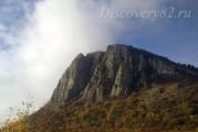
The mountains of the CMS are laccoliths, that is, lava domes squeezed out of the mantle millions of years ago. Beshtau is the largest (8 kilometers across) and the highest of them (1401m). But I did not climb any of its peaks, limiting myself to hiking along the slopes from Pyatigorsk to Zheleznovodsk. And on the way - uranium mines, the Second Athos Monastery, the city of Lermontov, the most beautiful Eagle Rocks and a warm April forest.
The first time I saw Beshtau from afar, I thought that it would be too tough for me, but in fact, climbing the central peak in a day and returning back is not so difficult. Moreover, numerous roads cross the mountain, and there are several convenient climbs to it. The easiest one is from the Lermontovskaya station (see the last part), the surroundings of which reminded me of the scenery for scenes of gang warfare from the cinema of the 1990s. The fact is that here is the largest car market in the North Caucasus, serving primarily the republics, where auto dealers open something very reluctantly. In the background - Mashuk, unmistakably identified by the TV tower:
To the left, behind the car market with its dubious personalities of Russian and Caucasian appearance, already scurrying about in the morning, the road to Beshtau begins. Ahead are the peaks of Two Brothers (1124), Big Beshtau (1401) and Goat rocks (1157), and on the title frame view from the opposite side - Goat rocks, Big Beshtau and Small Beshtau (1254), hiding Shaggy Mountain (1180) behind it. The first kilometers the road goes through an unpleasant area with concrete fences and the ruins of some industry:
On the left hand - Pyatigorsk. Garden partnerships near Lake Ivushka, high-rise buildings of the district with the poetic name Belaya Chamomile (according to the pre-revolutionary tuberculosis sanatorium - in those days this flower was a symbol of the fight against consumption), the long Dubrovka forest on Shaved Mountain (since half of it is bald) and the most distant of the 17 mountains Yutsa (973) and Dzhutsa (1190), behind which you can see the Caucasus.
But the center of Pyatigorsk is not visible from here - it is at the foot of Mashuk:
But now, from the flowering bushes at the foot of the Goat Rocks, an old industrial abandoned building appears. This is "settlement number 1" - nothing more than the remains of a uranium mine enrichment plant, quite unexpected in the resort area.
The local laccoliths consist of rather specific rocks - I already wrote in one of the previous parts about beshtaunit - a hard and corrosion-resistant stone used in engineering. And there are also davidites and lermontovites - uranium-cerium ore. In the onset of the Cold War, the USSR was in dire need of uranium - the raw material for atomic warheads, and mined it where he could - a few months ago I already showed the first Soviet one in (Kyrgyzstan). Beshtaugorsky uranium has been known since the 1930s, "settlement No. 1" was built in 1949-53, and mining on it was carried out until 1976. By analogy with the same Mailuu-Suu, most likely the surviving building was a factory power plant - the enrichment farik itself should have been demolished as "dirty".
They say that Beshtau is full of adits that form the largest system of catacombs in Russia, according to various sources, from 160 to 230 kilometers long. The entrances to the adits are marked on wikimapia, but here are the notes of a person who has been inside them.
Of course, uranium could not help but give rise to traditional horror stories: supposedly, both the background on the mountain in Chernobyl and giant mushrooms grow here, the locals will never buy such ones, but cunning mushroom pickers poison unlucky tourists. And de prisoners worked in these mines and were buried there... In short, I don't presume to judge the authenticity of the rumors. Beshtau is a place confused without any radiation. And you can go to it several times - for example, on the slope of the Big Beshtau there is the so-called Temple of the Sun, which many consider to be a Scythian megalith (which, to be honest, I strongly doubt). But I took a course to the foot of the peak Two Brothers - and I suspect that the name of this mountain was given by those two remnants on its "facade":
Approximately 4 kilometers from the Lermontovskaya station, the ascent ended - I went to the ring road built in 1927, encircling all 5 peaks at a good height. She herself passes approximately at the same level, then rising, then falling, and I turned left, heading clockwise:
Along the road there is a forest, a slope on both sides, an abundance of flowers and stones. On some stones there are biblical quotes: the paved part of the road leads from Pyatigorsk to the Second Athos Monastery, which, however, is still a few kilometers away.
Sometimes the warm forest on the slope parted, revealing the panorama of Pyatigorsk.
In the distance, already familiar Yutsa and Dzhutsa, and right at the foot of the low Pine Hill, also similar to laccolith.
A wide field and a stalinka with a tower are not an abandoned terminal of the old airport, but a hippodrome founded in 1885 near the Skachki station - one of two in Russia of federal significance, along with Moscow.
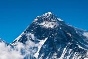
And in the distance, the Caucasian peaks are blazing, which I will not even try to identify, but apparently this is Kabardino-Balkaria, east of Elbrus. The very highest point of Russia that day was not visible behind the clouds lying on its slopes, but on other days it loomed in the background more than once.
Behind the back is Mount Two Brothers:
And in the distance, the outline of Camel Mountain (885m) looms - the westernmost of the 17 laccoliths, it first appears in sight on the road from Stavropol. On the slopes, as you can see, there are a lot of cars - Beshtau is popular with both holidaymakers and locals, and I even saw a jeep with South Ossetian license plates here.
We continue our way to the monastery - in fact, I walked for a long time, an hour and a half, hoping to see temples at every turn. Here on this rock they are going to recreate the icon that adorned the cliff before the revolution:
In the meantime, just such a memorial plaque - probably crashed on this rock in a car:
And finally, the Second Athos Monastery itself appears against the background of Big Beshtau - how strange and at the same time organically the Russian church looks in the mountains! This is the temple of St. George the Victorious (1999), but the cylindrical building is such an original fraternal building:
The monastery was founded in 1904 by two monks from the Greek Athos, and since the New Athos monastery in the Caucasus was already 30 years old, it was called the Second Athos. In those days, it was known for its strict charter and fidelity to traditions, therefore, in the age of modernism and renovationism, it very quickly earned the glory of a stronghold of genuine Orthodoxy. In 1927, the Second Athos was closed, and gradually destroyed - this is what his Assumption Church (1906) looked like:
In the new church, apparently, they want to play with Greek motifs, and in general, I would say that the second Second Athos Monastery, revived in 1997-2001, is architecturally more interesting than the first:
Here is an example of a church open sky- they say they wanted to build a new cathedral here, but abandoned the idea because of the threat of landslides:
On the last frame, do you see a crevice between the "eagle" and a lone pillar a little to the right? That's where I went:
View from the crevice to Sheludivaya Mountain and three cities near it:
View forward - as you can see, I'm not alone here, two whole families enthusiastically climbed the cliff - husbands-wives and boys of 10-12 years old. I think that Beshtau is not so crowded on weekdays, especially since I was here not just on Sunday, but on Easter.
Behind the next turn is an abyss, and Zheleznovodsk is visible between the rocks:
It turned out to be not so difficult to climb the "eagle's head" - the sharp turns on the trail are even equipped with an impromptu handrail:
And the round platform at the top at once reminded me of the place of the duel between Pechorin and Martynov Grushnitsky and the rock where he climbed under the cries of "Give me back the sausage!" Father Fyodor - being neither one nor the other, she serves as an ideal image of Ciscaucasia in the imagination of a Russian writer.
Top of the cliff with a small grotto:
And the view through this grotto:
Closer mountains are Sharp and Dull (767m, also Kabanka), further - Bull and Camel. There are two cities again in the frame - Lermontov on the left, Zheleznovodsk on the right. And below is not a military unit (as I thought), but a huge abandoned pioneer camp "Eagle Rocks":
To the right - another interesting mountain quintet. On the left - Dull and Bull, on the right - Zheleznaya (853, closer) and Razvalka (926, further) hanging over Zheleznovodsk, and in the middle - Honey Mountain (725m), the last of the "satellites" of Beshtau:
It is against the background of the non-resort part of Zheleznovodsk:
Zheleznovodsk is a small city (24 thousand inhabitants), but it has a very interesting structure. Its center and resort part is in a narrow (less than a kilometer) valley between Beshtau and Zheleznaya, and the main part of the residential areas is on the plain to the east, and such isolation of the resort area gives it an intimacy.
The most important sights are Ostrovsky's baths (1893) at the station at the bottom left, at the top left - the palace of the Emir of Bukhara (1912, indeed, in fact, a personal sanatorium that the ruler of vassal Bukhara built for himself here), at the top right - Pushkin Gallery (1901, kursaal), well, at the bottom of the local administration.
To the left is the Church of the Intercession, built in 1996 in the building of the New Van (1912), and the house with a turret below is on the forecourt:
And in general, I decided to go to Zheleznovodsk. But first we had to get down. and here I was very stupid - from the rocks of tears without problems, and then I decided not to go back, but to look for some kind of path. True, there were paths, but they all led up, and I was tired and went along the one that went downhill. She eventually dissolved at a rather steep slope, along which, through the stones, fallen leaves and flowering grasses, I decided to go down. The descent turned out to be not that dangerous, but boring and difficult. In one place I grabbed a thick dry branch, it broke off and right in my hand with a decent speed of inertia flew into my eye. By some miracle, I managed to close my eyes, but the blow turned out to be such that a natural echo resounded in my head. Not so much from pain, but from fright, I howled and realized that I was afraid to open my eyes - what if I'm crooked now ?! But I did open it, and it turned out that I see everything as I saw it before, only the "blind spot" lasted another 20 minutes. Later, I discovered that there was no bruise or even hemorrhage left from the blow, although I ached somewhere inside the eyes for another couple of weeks . In general, I just can’t get rid of the idea that all the dangers come from people ... however, for the first time in the Road to the Eye, I received it not from some gopnik, but from a tree. Soon I again went out to the flourishing crowded Ring Road:
And I turned at the direct descent to Zheleznovodsk, to which there are another 2-3 kilometers downhill:
The Palace of the Emir of Bukhara and the Soviet buildings of the Telman sanatorium. It seems that for the first time I walked from city to city (except for my periodic walks from home to neighboring Lyubertsy):
The road led me to the station behind these trees. By the way, how did you correct me
According to the nature of the relief, the region of the Caucasian Mineral Waters is divided into two parts: the northeastern one, where laccolith mountains rise against the background of the plain, and the southwestern one with characteristic features mountain landscape. In the south-western part lies the rocky ridge, uniform in relief, from which the Bermamyt plateau gently slopes down to Kislovodsk with the flat peaks of the mountains Big (2,643 m) and Small (2,592 m) Bermamyt. From these peaks a majestic panorama of the Main Caucasian Range opens from the very high peak Europe - Mount Elbrus (5,642 m). About 40 thousand years ago, Elbrus was an active volcano. Since then, he has been calm, but scientists have proven that in the deep bowels of this mountain there are formidable volcanic forces that can be used by humans. Mount Shatzhatmaz (2,140 m) is located on the Bermamyt Plateau, where the Mountain Astronomical Station, a weather station, and the scientific base of the Institute of Atmospheric Physics of the Russian Academy of Sciences are located. To the north-east of the Bermamyt plateau is the Pasture Range, divided into two parts by the Podkumok River. One part is called the Dzhinalsky Range, the other - the Darya Heights (1,300-1,500 m above sea level). From the Darya heights to the northeast, the Borgustan Plateau descends gently. In the middle of the steppe zone of the Caucasian Mineral Waters, 17 exceptionally peculiar laccolith mountains (failed volcanoes) rise: Beshtau (1,399.8 m), Dzhutsa (1,198 m), Zmeyka (994 m), Mashuk (993 m), Yutsa (972 m ), Razvalka (930 m), Golden Kurgan (884 m), Camel (885 m), Sharp (881 m), Zheleznaya (859.4 m), Sheludivaya (875 m), Bald (740 m), Honey (721 m), Kokurtly (406 m), Byk (821 m), Kabanka (Dupaya) (772 m), Mount Dagger used to have a sharp summit ridge and rose to 507 m, but when mining the stone, the upper part of the mountain was cut off. Ancient volcanic processes created these mountains. The strength of the magma rushing from the bowels of the Earth was not enough to go outside, and magma, magmatic gases and vapors only lifted some parts of the earth's surface, forming domed peaks. Where the magma found its way out, it solidified in the form of exposed rocks. The low height of these mountains, the presence of gentle slopes and rich vegetation make them accessible and attractive for organizing nearby tourism.
Beshtau (Five mountains). The dominant mountain Beshtau, called by the poet five-headed, really has five peaks, hence its name (from the Turkic "besh" - five and "tau" - mountain). This is the highest of the laccolith mountains, located in the center of the northeastern part of the Caucasian Mineral Waters. From its peaks you can see all the laccolith mountains, the panorama of the resort area and the mountain range of the Caucasus Range. Beshtau consists of five peaks: Beshtau, Small Beshtau, Two brothers, Goat rocks. The slopes of Beshtau are covered mainly with deciduous forest. Up to a height of 1100 m, the slopes are covered with beech-oak-ash-hornbeam forest, which makes up the main part of the Beshtaugor forest, consisting of more than 60 species of trees and shrubs. The oriental beech plantation located in it occupies 177 hectares. In the subalpine zone, broad-leaved forest is replaced by crooked forest with cold-resistant warty birch and Caucasian mountain ash. Above is a zone of steppe subalpine meadows, forming a clearing of 461 hectares on the main peak. Representatives of typical subalpine meadow flora are found on it - lovely primrose, Wilhelm's mytnik, yellow rhododendron. Among the endemics of the mountain, poppy bracts are known, which are distinguished by very large flowers. The forest is rich in mushrooms, mainly lamellar (especially champignons, chanterelles, mushrooms, milk mushrooms, umbrellas). The fauna of the mountain is also diverse: wild boars, birds of prey, pheasants, hares, foxes.
It is best to climb to the top of the mountain from Zheleznovodsk or Lermontov.
Zmeyka (from the Turkic zhlak-tau - “serpentine mountain”) is a remnant igneous (paleovolcanic) mountain. Height 994 m. Natural monument. The second largest mountain in Pyatigorye after Beshtau, occupies an area of about 20 km². Located 4.5 km southwest of railway station Mineralnye Vody. In plan it has an oval shape slightly elongated to the northeast. The upper part is composed of subvolcanic intrusion of beshtaunites, forming a picturesque rock ledge with an area of 2.8 km². The lower part of the slope is dominated by clay shales of the Maikop series, in some places overlain by the remains of a cover of Neogene volcanic rocks - tuffs and tuff lavas. The destruction of the summit body of the Beshtaunites led to the widespread development of scree.
At the southwestern foot of the mountain there is the Zmeykinskoye deposit of carbonic hydrocarbonate-sulfate calcium-sodium waters with a mineralization of 3.2-5.6 g/l. Most of them are extracted using a well from a depth of 1482 m. The water temperature at the wellhead is 70-74 ° C, the flow rate is 9 l / s. The eastern and, partially, southern and northern slopes of the mountain are disturbed by an extensive quarry, in which beshtaunit was mined for construction purposes in the 30-80s of the 20th century. The quarry is a vast artificial outcrop about 2 km long and up to 200 m high. It contains features of the occurrence and internal structure of the subvolcanic intrusion of beshtaunites, their relationship with the host sedimentary rocks, as well as the remains of the cover of Neogene volcanic tuffs, which determines the scientific value of this excavation. After the cessation of stone mining in the quarry, a natural restoration of the vegetation cover occurs.
The mountain is covered with forest and mountain-meadow vegetation, which is part of the northern part of the Beshtaugor forest. Hornbeam-ash-oak and hornbeam-beech forests predominate, numbering about 60 species of trees and shrubs. At the top, the forest is replaced by glades of subalpine meadows, and at the foot - meadow-like grass-grass steppe with high species saturation. Of the rare protected plant species on the mountain, there are oriental beech, dwarf euonymus, Nefedov's cotoneaster, long rosehip, Caucasian ash-tree, monofraternal lily, several species of hawks.
It is a regional complex (landscape) monument of nature
Mount Mashuk. To the north-west of Beshtau, Mashuk rises in the form of a shaggy hat - one of interesting mountains Kavminvod district, which is also the best panoramic point in the immediate vicinity of Pyatigorsk. For centuries, legends about Mashuk lived and live among the people. Here is what one of them says. A long time ago, the Khan of the Golden Horde Kaplan-Girey with a huge army suddenly attacked Kabarda. Uninvited guests they took away valuables and livestock, subjected the population to all sorts of abuse. Among the local residents, Mashuk was distinguished by great courage, who took revenge on the invaders for the desecrated honor and death of the bride. Khan, alarmed by the brave deeds of the national hero, threw his best warriors to capture the horseman Mashuk. On one of the ledges of the mountain, Mashuk with a group of comrades was surrounded. A fierce battle ensued, in which Mashuk's comrades were killed. Exhausted, Mashuk did not want to be captured and jumped from a cliff down onto gray stones. The news of the death of Mashuk filled the hearts of the people with anger. The people have risen. At night, uninvited aliens were killed, and the remnants of the army were defeated. Kabarda got rid of the foreign yoke and for some time achieved independence. In memory of Mashuk, the people named the mountain with hot and cold springs, where the legendary hero of Kabarda fought and died. A stay at the Caucasian Mineralnye Vody would not be complete without an excursion to Mashuk. The easiest way to climb is along the well-maintained health path. The ascent and descent takes 3-4 hours. The lift will take 3-5 minutes by cable car. From the top of Mashuk, in good weather, vast expanses are visible from the Main Caucasian Range to the steppes of Stavropol. The road to Mashuk will lead to a high obelisk - the grave of the outstanding military topographer A.V. Pastukhov. The Perkal dendrological nursery is located on the northern slope of the mountain.
Mount Iron. It has a regular conical shape. From the top of the mountain, a wide panorama of the surrounding mountains and Zheleznovodsk opens up. The main wealth of the mountain is 23 sources of mineral waters, of which 16 are used. In the places of their outpouring along the perimeter of the mountain, nine sinter bodies of travertines were formed. Iron hydroxides precipitated from the waters give them a rusty color, in connection with which the mountain is called Iron. The waters are carbonic, sometimes radon-containing, predominantly sulfate-bicarbonate calcium-sodium with a mineralization of 3-4 g/l. Salt-alkaline waters are less common. According to the water temperature - cold (Nezlobinsky, Zavadovsky, Gaazovsky springs), warm, 23-35 ° C (Vladimirovsky) and hot, 35-61 ° C (Slavyanovsky, Smirnovsky, Lermontovsky springs, named after Semashko). Zheleznovodsk waters differ from other deposits of the Caucasian Mineral Waters in their complex ionic composition. The mountain is covered with a lush broad-leaved forest, which is part of the Beshtaugor forest. The forest stand is dominated by hornbeam, ash, oak, maple, linden. Beech is common in beams with increased moisture. In the undergrowth - hawthorn, hazel, elder, privet. The herbaceous cover is also rich, in which there are many medicinal plants: Caucasian belladonna, fragrant violet, large celandine, male fern, large-cup primrose, medicinal valerian. On the eastern slope, on the basis of a natural forest, in 1825 the Zheleznovodsk resort park was founded. Medical routes are laid along the forest slopes of the mountain.
At the foot of the Zheleznaya, between the Slavyanovsky and Smirnovsky springs, you can see a shapeless stone block, which is a fragment of the Zheleznaya mountain. This fragment weighs 1700 pounds. He fell off Zheleznaya on the night of April 10-11, 1892. and frightened the inhabitants of the city with his roar.
Mount Medovaya
Monument of nature. It is located on the southwestern outskirts of the city of Zheleznovodsk. It is a rock ledge of Beshtaunites 500 × 150 m in size, towering 120 m above the foot. The name is associated with the yellow color of the rocks, dotted with holes resembling honeycombs. Disturbed by a quarry where beshtaunit was mined for construction purposes in the 20th century. The lower part of the slopes is covered with broad-leaved forest, which is part of the Beshtaugor forest. On Medovaya there is a place of ancient human settlements of the Byzantine era. Mount Medovaya is one of the sights of Zheleznovodsk, often visited local residents and vacationers. A route leads to the mountain from the Zheleznovodsk sanatorium "Oak Grove". The best way to climb the mountain is along the path from the south side. The way to the top will be 3-4 km.
Mount Kabanka (Dupaya). Monument of nature. It is a picturesque rocky ridge measuring 150 × 350 m, elongated to the northeast and composed of beshtaunites, resembling a lying boar from the side. It has the appearance of a step with a gentle southern and steep western, northern and eastern slopes, broken clefts and cracks, with a flat top (with which, among other things, one of the names of the mountain, Tupaya, is associated). The slopes are covered with broad-leaved forest, which is part of the Beshtaugor forest. There are remains of ancient settlements of the III-IV centuries on Kabanka. BC e. The path to it lies from the Oak Grove sanatorium in Zheleznovodsk, past Mount Medovaya, along a forest road to the second ravine at the foot of Mount Tupoy. From the ravine - rise to the valley between Tupa and Ostra. From this valley, you can start climbing to the top of Kabanka, covered with a small forest. The length of the route in both directions does not exceed 7 km, the elevation angle is 5-10 *, in some places up to 18 *.
Mount Razvalka (Sleeping Lion). The upper part of the mountain is a steep rocky ridge 1 km long and up to 200 m in relative height, composed of light gray beshtaunites. The southern half of the ridge rises sharply above the northern one and outwardly resembles a lion's head, which is why in the 19th century the mountain was called the "Sleeping Lion". The ridge is broken by cracks into many blocks with sheer walls and deep crevasses, and this is connected modern name mountains - Razvalka. The mountain is composed of solidified magma, which rose three times from the depths. The foot of the rocks and the lower part of the mountain are dotted with large-block ruins of beshtaunites. On the northern slope of Razvalka, a powerful Grafsky spring of cold (1-5 ° C) fresh water beats, which in the past was used to supply Zheleznovodsk.
One of the attractions of Razvalka is a permafrost area, which has no analogues in the south of temperate latitudes. Permafrost occurs on an area of about 1 ha on the northern and eastern slopes in the form of a strip at an altitude of 620-720 m. It is associated with the inflow of cold air from cracks with a temperature of -1 to +4 °C. For this reason, ice crystals remain in deep cracks even in summer. It is possible that relic permafrost, which arose during the era of the Pleistocene glaciation, is still preserved in the bowels of the mountain.
Permafrost has had an impact on vegetation and animal world the mountains. If most of Razvalka is covered with broad-leaved forest with islands of mountain-meadow and rocky vegetation characteristic of the Beshtaugor forest, then an unusual rowan-birch crooked forest has formed on the permafrost site with an association of cold-loving plants such as raspberries, honeysuckle, alder, aspen, bird cherry, bladderwort brittle, fireweed. Of the animals, snow voles and some insect species are found here, which are found in the Caucasus only in the highlands.
Razvalka has several archaeological sites: Saltpeter cave with a cultural layer containing stone tools and arrowheads (IV-III millennium BC); Razvalskoye settlement (VIII-VII centuries BC); remains of a necropolis (VI-V centuries BC); remains of an early medieval wheeled road.
Large and Small saddle. Mount Big saddle is the highest in the vicinity of Kislovodsk and Pyatigorsk. The path to it lies through the Kislovodsk Park, up the path of the third path of the health path past the Temple of the Air, the Red Sun, then the Blue Mountains will stand on the way, which are a group of sheer bare rocks with deep cracks and grottoes. This is part of the Jinal Range. A wide path then goes along a plateau covered with dense grass and flowers. Ahead rises the Small Saddle, its height is 1325 m, it is 500 m higher than the Narzan Gallery. Elbrus and the entire Kabardian plateau are clearly visible from here. Three kilometers from the Small Saddle is the Big Saddle (1409 m), from which not only the Caucasus Range, but the entire region of Mineralnye Vody is clearly visible. Hundreds of fragrant and medicinal herbs bloom in the vicinity of the Great Saddle in warm weather, filling the air with the buzzing of bees and fragrance. In spring, blue and pink snowdrops break through the snow, growing only in the mountains. Warm weather comes to Kislovodsk in spring, trees blossom, however, on the slopes of the Big Saddle you can still find the remains of snow.
The walk is an excellent exercise, its length in both directions is about 20 km. Climbing the Big Saddle is better to start early in the morning, at 5-6 o'clock, in such a way as to return to dinner.
Rim-Gora is the largest monument of the material culture of the Kislovodsk Valley. It reflects the life of the local population at the end of the first and beginning of the second millennium of our era. The mountain is located among a wide valley 18 km west of Kislovodsk, in the valley of the Podkumok River. Its height is 1094 meters above sea level. At the top, clear traces of human life and activity are visible. Carved steps, skillfully carved pools for storing water have been preserved in the rocks, household items and decorations of people, numerous catacomb burials have been found. Climbing to the top of Rim-Mounta is possible only by steps carved into the rocks. Why is the mountain called Rome Mountain? There is a legend: In ancient times, a few, but brave and courageous people lived at the foot of the mountain. They were renowned for their hard work and hospitality. Once they were attacked by merciless enemies. The highlanders defended their land and aul steadfastly and bravely, but the forces were unequal. And the highlanders went to the top of the mountain and began to prepare for defense. “Submit to fate,” the aliens told them, “you fought courageously, but you are few. Lay down your weapons and leave this land. Decide before morning. The highlanders thought all night. “We will fight,” some said. It’s better to leave and save our family,” others said.” But then a young man came forward, wrapped in a white hood.
- The land is great, but there is no land that will become our own. Pitiful is the people who will lose their native land, which fed and watered them. Let us die, but we will not betray the earth, the juices of which we carry within ourselves. In the morning, a fierce battle continued. There were fewer and fewer defenders of the fortress. Enemies already with joyful cries rushed to the last assault. But a young man in a white cap rushed forward.
- Oh, my brothers! he cried. - How much is the life of a highlander? Let our swords speak for it! The horseman tore off the hood from his head and blindfolded the horse's eyes with it. Long hair flowed over his shoulders. It was a young girl. She sent her horse into the thick of the enemies. The highlanders rushed after the young heroine. Foreigners mingled, trembled and left these places forever. The girl Rum saved her people and her native land from enslavement, and the mountain was named after her.
Mount Ring. A through hole in the spurs of the Burgustan Range, 11 m in size, formed by weathering, served as the name for this wonderful creation of nature.
There are many caves in the mountain range of the Burgustan Range, and among them a ring with a diameter of eight meters has formed. The caves and the ring itself are the result of moisture and weathering.
Ring-mountain is not only a monument of nature, but also a place associated with the name of M.Yu. Lermontov. The poet has been to Kislovodsk more than once, he knew its surroundings. On June 12, Pechorin’s diary entry: “... Three versts from Kislovodsk, in the gorge where Podkumok flows, there is a rock called the Ring, this is a gate formed by nature; they rise on a high hill, and through them the setting sun throws its last fiery glance at the world. Princess Mary and her entourage went for a walk to the Ring. An entry was made about this in Pechorin's diary: “A large cavalcade went there to watch the sunset through a stone window ...” - Galleries of niches formed near the Ring Mountain, separated by columns turned by the winds.
Ring-mountain is one of the sights of Kislovodsk. From here opens beautiful view to the city. In one of the caves, next to the ring, V.G. Gnilovskaya discovered the inscription: “M. Lermontov
I visited your sacred grotto
I am by virtue of this vow.
I'm tearing my soul to you, priceless,
But I don't get an answer from you!
1837 ap. 16 A. von Ts...”.
It is believed that the inscription was left by a friend of M.Yu. Lermontova M.I. von Zeidler.
Good Mountain. It is located 20 km west of Kislovodsk. From Gud-Gora there is a beautiful panorama of mountain ranges and picturesque gorges. From Gud-Gora you can go down to the Kanta-Tukele tract. You can travel part of the way by bus, most of the way you need to walk.
In the south of the Stavropol Territory in the foothills of the Bolshoi Caucasian Range there is amazing place- Caucasian Mineralnye Vody. This resort corner is located at the junction of the Mineralnye Vody inclined plain and the northern slopes of the Caucasus Range, exactly in the middle between the Caspian and Black Seas. On the one hand, the region is surrounded by snowy peaks, and on the other hand, by the arid Caspian steppes. All this forms a very valuable healing climate, appreciated by balneologists and vacationers. Interestingly, the French Cote d'Azur and the Spanish Adriatic lie almost on the same latitude as the Caucasus.
Usually, the agglomeration of the cities of Pyatigorsk, Essentuki, Kislovodsk, Zheleznovodsk and Mineralnye Vody is considered to be Kavminvod. Although geographically CMS is much larger. Starting from the foot of Elbrus in the south and ending in the area of the city of Mineralnye Vody, the Caucasian Mineralnye Vody region covers an area of more than five hundred thousand hectares.
Given this, the CMS region can be attributed to the middle mountains, because maximum height above sea level reaches 2592 meters (Bermamyt plateau).
It is conditionally possible to divide the CMS into two climatic zones: south and north. The first will include Kislovodsk - there are more sunny days and there are almost no strong winds. This is a climate with pronounced features of the continental lowlands. Kislovodsk is located in a natural basin, surrounded on all sides by mountains that hold back clouds. Thanks to this, the sun shines in Kislovodsk 300 days a year. It is one of the sunniest cities in the world.
Pyatigorsk, Essentuki, Zheleznovodsk can be attributed to the northern part of the CMS, it is also very sunny and warm here, but the humidity and precipitation are higher. Although, quite often you can observe how it rains in one of the cities of the resort, while in other cities it is clear and sunny. The weather can change several times a day. It happens very quickly. There is even such a saying among the people: "North Caucasus - keep gloves in reserve."

Winters in the Caucasian Mineralnye Vody are warm; snow rarely stays longer than ten days. Snow in winter is less common than rain. In autumn, often, warm weather lasts until the end of November. The proximity of the Greater Caucasus Range and a large number of green spaces soften the summer heat. Spring is usually early: in April-May, many residents and vacationers already begin to swim in rivers and lakes.
History of the resort
The first relatively accurate information about the mineral waters of the Caucasus appeared in 1717, when Peter I gave the task to the life physician, Dr. Schober, to find and study hot waters near the first Russian fortress of Terki, later called Bragunsky. In his report, Schober described the springs in the lands of the Pyatigorsk Circassians, as the Kabardians used to be called in Russia. From that moment, the study of the healing properties of the Kavminvodsky mineral springs begins. Unfortunately, after the death of Peter I, all initiatives for the development of resorts in the CMS were stopped.
In 1780, at the foot of Mount Mashuk, the Constantinogorsk fortress was founded. The soldiers were the first to notice the healing properties of the hot springs of the future Pyatigorsk. For the study of mineral springs, the Academy of Sciences sends the doctor of medicine Peter Simons Pallas. He studied for a year medicinal properties water. In addition to the Pyatigorsk springs, Pallas also explored the Kislovodsk Narzan. He noted that water bursts out of the ground with great force and is able to lift a person bathing in it.
After the report of P. S. Pallas, the CMS region becomes famous. People come here for treatment from the most remote corners of Russia.
In 1803, Alexander I, with his rescript, assigned the resort status to the Caucasian Mineral Waters. Appropriations are allocated for the arrangement and development of the resort. Despite state support, the resort is developing poorly. The hospitals are in disrepair. The aristocracy prefers to travel to foreign resorts. So, according to data for 1860, Russians spent about 160 million rubles in foreign resorts.
In order to remedy the situation, in 1861 the Caucasian Mineralnye Vody were leased to the entrepreneur Novoselsky, and after that to A. M. Baikov. This did not give the desired results, and two years later the resort is again returned to the state.
Resort Development
In the sixties of the XIX century, scientists-researchers Smirnov and Batalin carried out serious work on the study of balneological features Caucasian resorts and mineral springs. A Geological Committee is being created, which conducts a comprehensive study of the subsoil. 1893 was marked by the opening of a railway line that connected all the cities of the resort with the Vladikavkaz branch. As a result, the resort is rapidly gaining popularity. By 1914, the number of tourists increased by more than 45 times. More than 100,000 people visited Caucasian Mineralnye Vody this year.

In 1919, the Caucasian Mineral Waters resorts received a safe-conduct and the status of "publicly important". The decree signed by V. I. Lenin saves the infrastructure from looting.
In 1920, the Balneological Institute was created in Pyatigorsk, which exists to this day. The Institute is engaged in the study of balneological factors in the treatment and prevention of various diseases.
During the Second World War, all the sanatoriums and boarding houses of the resort received the wounded.
Resort today
Today, there are about a hundred sanatoriums in the region, which are visited by more than seven hundred thousand people a year.

You can come to rest at any time of the year, but if you plan to come in the summer, it is better to think about purchasing tickets in advance. They say that in Soviet times in the summer in the cities of the Caucasus Mineral Waters, the number of people in the cities tripled due to vacationers. Of course, such popularity is explained not only by medical factors. One Narzan will not be full. The region has a large number of cafes for every taste and color. Probably, only here you can taste the dishes of a wide variety of peoples: Russian, Kabardian, Jewish, Azerbaijani, Turkish, Ossetian, Karachai, Armenian, Chinese, Japanese and even Vietnamese cuisine - choose, compare, evaluate. I'm sure you'll find something to your liking in each one. And yet, try not to get confused in the various ways of cooking barbecue and remember the main differences. After all, if you forget, you will have to repeat the entire course again, and one ticket may not be enough time.
If you are tired of culinary delights, then you should know that there are places to get spiritual food in the Caucasian Mineral Waters. Every city has a theater. In Pyatigorsk, this is the Stavropol State Regional Operetta (formerly it was called the Theater of Musical Comedy). In Essentuki it is Concert hall named after F.I. Chaliapin. In Kislovodsk, I recommend visiting the Philharmonic. This is one of the oldest concert institutions in Russia. In Pyatigorsk park them. Kirov, in addition to attractions, there are also concert hall"Fork". And there are so many 3D cinemas that it makes no sense to list them here.
In any of the KMV resort cities, numerous bowling alleys and billiards, as well as nightclubs with discos until the morning are at your service.

In addition to the attractions on the CMS, the attention of vacationers is offered more than a hundred various excursions, both one-day and designed for several days. Tour routes the most diverse: here you have Honey Waterfalls, and Arkhyz, ancient city Magas (where the oldest Christian churches in Russia are located), a trout farm and skiing, permafrost cave or Second Athos monastery. Do not count everything. It is very difficult to choose excursions on the go. Therefore, it is best to first read about them in advance, see reviews, photos and make a choice.
Every self-respecting Caucasian Mineral Waters resort town has its own park, at least one lake and picturesque medical health paths.
Terrenkur: from the French terrain - terrain and the German Kur - treatment, a method of sanatorium treatment, involving dosed loads in the form of walking.
These places are saturated not only true story but also literary. The bronze Kisa Vorobyaninov is still begging near Gukasov's coffee house, which is opposite the Lermontov Gallery, and his partner Ostap-Suleiman-Berta-Maria-Bender-bey still sells tickets near that very Proval.
Photos KMV


There are 17 unique laccolith mountains 1 in Cavminvody, each mountain has its own legend and special charm. You should definitely visit at least one of them. If you can’t afford to climb on foot, then to the Temple of the Air (Kislovodsk) and to the top of Mashuk (Pyatigorsk) cable car. Pyatigorsk lift is considered the fastest in Europe. In clear weather, panoramas of the Greater Caucasus Range open from there, which you will never forget. They say that it is worth coming to the Caucasian Mineralnye Vody only for the views that open from there. And you can take off the ground on a paraglider, enjoy the panorama and the feeling of free flight.

You will definitely like it here. Arriving in the summer, you will definitely want to return: admire the mountains in autumn colors or wander through the snow-covered parks. Here at any time of the year you can improve your health and find something to your liking.
1 mountain laccolith- can be considered as a "failed volcano", because the magma could not break out and only lifted the upper layer of sedimentary rocks, freezing under it in the form of a dome or hemisphere, often mushroom-shaped outlines. (Geographic encyclopedia).
Beautiful video about Caucasian Mineral Waters
Located in the south of the European part of the USSR, almost at the same distance from the Black and Caspian Seas, the Kavminvod region is conveniently located relative to the populated areas of the country and has good transport links with them. In administrative terms, it is part of the Stavropol Territory of the RSFSR, occupying almost completely the Predgorny district, part of Mineralovodsky, small sections of the Georgievsky and Malokarachaevsky (Karachay-Cherkess Autonomous Region) regions.
Population. Caucasian Mineralnye Vody is one of the densely populated territories of the North Caucasus (the average population density exceeds 150 people per 1 sq. km).
More than 400 thousand people live in cities and urban-type settlements - mainly Russians, Ukrainians, Armenians, Karachays, Circassians, Abazins, Ossetians, Kabardians and representatives of other peoples and nationalities of our country. The specialization of resorts also determines the specifics of employment.
The resort and tourist industry includes about 100 sanatoriums, boarding houses, camp sites, so every fourth of those working in the cities of the Caucasus Mineral Waters is employed at the enterprises of the industry. In general, more than half of the working population of the district is associated with servicing vacationers.
Mass at the resorts of the Caucasian Mineral Waters became the profession of a doctor. In pre-revolutionary times, a few doctors lived here, most of them arrived here for a period holiday season. Now thousands of doctors and nurses are constantly busy at the resorts of the Caucasian Mineral Waters.
Industry and agricultural production. Traditional industrial production in the area balneological resorts- bottling of mineral waters. The first bottling of mineral water was carried out here in 1847 by order of Count Vorontsov - 300 bottles of Essentuki (No. 4) were poured. In 1873, bottling in Essentuki was resumed at a specially built water bottling plant. In 1896, a plant for the production of liquid carbon dioxide was built in Kislovodsk and narzan was bottled. In addition, they produced bottling of mineral waters from Slavyanovsky and Smirnovsky springs in Zheleznovodsk. In 1913, all enterprises of the Kavminvod produced 9.6 million bottles of mineral water. The production of narzan grew especially fast, which international exhibition in Reims (France) received the highest award. Most of the products of mineral water bottling enterprises were exported to other regions of Russia and exported to countries Western Europe, Turkey and Iran.
Now three local factories and a workshop annually produce more than 200 million bottles of mineral water. The healing waters of Pyatigorsk, Kislovodsk, Essentuki, Zheleznovodsk are known throughout the world. In the future, with the construction of a new plant for bottling mineral water, the output of this product will almost double. The products of the Kislovodsk and Pyatigorsk souvenir factories, the factory, who rested in Kavminvodaz, are taken to all corners of the country and abroad; "Souvenir" in Mineralnye Vody Souvenirs are also made by factories of art products, workshops at industrial plants. The range of products of these enterprises is wide - these are traditional glasses for drinking mineral water, and products made of cupronickel, horn, porcelain, crystal, carved caskets. Since 1896, the largest glass factory in the North Caucasus for the production of bottles for bottling mineral water has been operating in the village of Andzhievsky (near Mineralnye Vody).
Food, clothing, knitwear, shoes, furniture, building materials, agricultural machinery - these are far from complete list products manufactured industrial enterprises Kavminvod.
Agriculture in this area is mainly focused on meeting the needs of vacationers. In its structure, the share of vegetable growing, dairy and meat animal husbandry is high. Resorts are major consumers of dietary meat. Powerful poultry farms operate in the suburbs, including Beshtaugorets, Koltsegorskaya, and Pyatigorskaya. They also provide a third of the eggs produced in the Stavropol Territory.
The district produces one sixth of the region's vegetables, one third of them - in greenhouses. Almost all winter in early spring fresh vegetables are delivered to the table of vacationers from the greenhouses "Teplichny", "Kislovodsky", etc. The largest enterprise of protected ground is the plant "Flowers of Stavropol", which supplies tens of thousands of flowers to the trade network of resorts and beyond. The farms of the Piedmont region annually produce tens of thousands of tons of milk, meat, vegetables, and fruits to provide for vacationers at the resorts.
Transport. An electrified Moscow-Baku highway with branches to Kislovodsk and Zheleznovodsk, an asphalt highway Rostov-Baku pass through the territory of the district. Mineralnye Vody Airport is connected by direct flights to all major centers of the Soviet Union. It took 13 days to get from Moscow to the resorts of the Caucasian Mineral Waters in the last century. Nowadays, an airliner delivers passengers here from the capital in two hours. From the airport to the resort towns less than an hour by bus or taxi.
For a trip from the airport to the resort towns, you can use the services railway. You need to take the city bus to railway station in Mineralnye Vody, from where suburban trains go to Kislovodsk 70 minutes, to Essentuki 45 minutes and to Pyatigorsk half an hour. Those who go on vacation to Zheleznovodsk need to change trains at the Beshtau station.