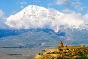
Paragilmen lake Crimea. Mount Paragilmen in Crimea
Monetary, Beautiful, Crimean, High-altitude - this is all Mount Paragilmen, the routes to which have long been well known to tourists who prefer active recreation to sitting in hammocks.
Mount Paragilmen is located near the village of Maly Mayak and is one of the most attractive points for all travelers.
The name is translated from Greek as “to cross the line, to go beyond” and if you dare to climb a high-rise, you will understand exactly what it is about - a breathtaking panorama of views opens up and it seems that a little more, and the edge of being will be violated. There will be complete unity with the birds and it will be possible to literally fly up through this air filled with aromas and wind.
The origin of Mount Paragilmen is attributed to the Upper Jurassic period, which is also confirmed by the composition of the mountain - marbled limestone interspersed with conglomerates. Once upon a time, a piece called Paragilmen broke away from the main mountain range and gradually slides into the Black Sea.
The place is well-known and has already been shown in our films more than once, for example, it was in the vicinity of Paragilmen that the film “Hearts of Three” was filmed. And now, if you have to see a film, pay attention to the gorgeous views of nature that are available for real viewing, you just have to come to the Crimea and visit Paragilmen, choosing routes according to your strength and your own taste.

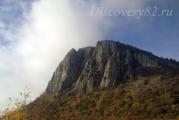
In addition to charming views, Paragilmen will give you a lot of interesting things. For starters, this is an ascent to a point 857 meters high, and the southern slopes are quite steep, reaching up to 60-80 degrees, so only experienced climbers will submit. Travelers who want to make a regular walk go along the northern side, where they can safely climb to the top, stretching to Babugan-yayla.
Attractions are found literally at every step. Two huge yew trees, keeping many secrets in their evergreen crown, have been waiting, meeting and seeing off travelers for many hundreds of years. Judge for yourself: the yew grows in thickness by 1 mm per year, while the width of the trunk of each of the trees is 0.7 meters. It is worth estimating the age and the yews turn into real time travelers who calmly look at everything that happens, perfectly understanding the transience of life. You should not try fruits that attract with their red tint - poisons that are deadly to humans were often prepared from yew. Paragilmen is not as harmless as it seems.
The mountain shines with special beauty in autumn, when all plants literally begin to compete in the richness of decoration. By the way, about plants, there are more than 30 species of trees, many medicinal herbs, mushrooms, and shrubs. Many species are listed in the Red Book and are specially protected by law. Every now and then, when climbing, there are smooth, run-in by wind and sun huge boulders. These are usually left by glaciers, but in the southern part of the Crimea there are no, and there were no glaciers, so the origin of the stones is still a mystery. Travelers will be greeted by a pear grove, the old trees of which still flutter with silver leaves in the mountain wind, flowers, fragrant herbs, and it will be easy to breathe throughout the journey, despite the rise. The air here is healing, calming the nerves, giving pleasant emotions and complete healing from headaches.
Routes to Paragilmen
There are many tourist routes to Paragilmen. One of them originates from the bridge in the village of Maly Mayak, passes by the Talma spring and leads to the Babugan plateau.

There are 4 routes for climbers: along the Left and Right ribs, along the Center, Troika through the fireplace. All routes require mandatory experience and special equipment. The passage time is up to 4-6 hours, depending on the complexity. The routes differ in beauty, varying degrees of difficulty. If you have a great desire to conquer a sheer wall, then you are in the village of Vinogradnoye, where you can take a coach and go through an easy path with him, accessible to a beginner. Climbers with experience prefer to get to Paragilmen on their own, reaching the stop "Sharkhinsky quarry", go up the road for half a kilometer and turn right, where the base camps are located, right under the mountain. Here in the camp there is an opportunity to discuss novelties, be happy for your comrades and, perhaps, find out the news and opening of waypoints.
Well, for ordinary tourists, the road also lies to Vinogradnoye, from where, past a small lake full of mountain waters, a path leads through the Sharkhinsky quarry to the foot of Paragilmen and you can start climbing, carefully moving to the intended point.
The length of routes to Paragilmen is small, from a quarter of a kilometer. Let a person with minimal training be able to pass, especially if this is not a run, but a smooth and measured journey. Rallies and meetings of climbers, local historians and youth gatherings often take place on Mount Paragilmen. The views of the surroundings are truly magnificent, bewitching, and therefore Paragilmen remains one of the popular points on the tourist map of Crimea. At the same time, the height is quite accessible, which means that by choosing the time and suitable routes, you can climb Paragilmen with the whole family. And do not be surprised if you meet freshly dug pits on Paragilmen - this means that the legend of the treasures of Sufakis has not been forgotten and treasure hunters are still full of strength and optimism to find the untold riches buried according to legend, precisely on Paragilmen!
Crimea, Paragilmen
Technical description of routes to Paragilmen. A photo report of the passage of two routes in April 2010 is attached to the description.
Described routes:
"On the left edge" 2A
"On the right edge" 2B
"Three through the fireplace" 3A
"Center of the Wall" 3B (4A)
Route "On the left edge" 2A

Route start
The route starts from the couloir, between the main wall and the ridge along which the "one" passes. From the upper road, go along the path to the couloir, the beginning - from the shelf, 10 meters below the tree growing on the left side of the buttress.
0-1 By simple climbing, up to the right to the tree, from it continue to the right up, go to the buttress, the relief is rich, blocky. Further up the station on the ledge, there are 2 bolts. 40 m III
1-2 Up the crack, then along a steep inner corner, after it through a small wall, and along a simple relief, go to a good ledge, here is a station, there is a bolt. This is the key rope. 30m (III, 10m IV)
2-3 This section can be walked in 2 ways - the 1st (more difficult) option from the station up, under a small cornice, it goes around to the right, further up the inner corner. At the top, exit the corner to the left, and exit onto a ledge. Station on a bolt + own. 30 m (III, 5 m IV).
2nd option: from the station to the left upwards, go to the inner corner, along the corner go to the flattening, here to the right upwards, to the station. 35 m (III+)
3-4
From the station up, along the buttress, climbing is simple, large blocks. Station on the shelf, there is a bolt. 45 m (II-III)
4-5
Up the buttress, get to the top of the "shovel" Station on the tree. 50 m (II+)
5-6
On a horizontal ridge, easy climbing, reach the yayla. 70 m (I-II)
Nice route. To pass, you need a 50m rope, loops, friends, stoppers, large and medium.

Passage of the route.
2 bundles:(Alexander Lavrinenko - Odessa, Tatyana Senchenko - Kiev), (Maxim Kolodyazhny - Nikolaev, Yuri Sobetsky - Poltava)

Paragilmen (panorama)


First rope


Often found on routes, wooden wedges were previously used for insurance.


Access to a simple ridge

End rope. Access to a simple ridge


Route"On the right edge" 2B
The route passes along the right edge of the wall without going to the wall. Unfortunately, it is almost invisible in the photo. You can start the route right along the rib, you can go to the left of the rib, along the system of slots and internal corners, it’s a little more difficult and shorter, about 20 meters, you can go to the right of the rib from the couloir. The description shows the left start of the route.
0-1 Up the simple rocks, towards the inner corner, further along the corner. At the top of the corner, climbing becomes more difficult. Station on a shelf in front of a steep wall. There are bolts and hooks. 43m (III, 5m IV)
1-2 key rope . Go up the crevice into the inner corner. The corner throws out, the climbing is difficult. Bypassing the overhang on the right, up the inner corner. Shelf station. There are bolts and hooks. 30m IV (5m V)
2-3 Up along the inner corner, taking it to the right, go to the shelf from it up, under the base of the fireplace. Station on a bolt and hooks. 45 m (III-IV)
3-4 Up the fireplace 10m, on a ledge. Go around the next fireplace on the right, along the system of cracks, and move in the direction of a semi-dry tree. Go around the tree on the left, and up, along the crevice, then along the corner, go to the top of the "Shovel". The station is on its own, the relief is rich. 50m (III, 10m IV+)
4-5 From the top of "Shovel", go along the horizontal ridge to the yail 70 m (I-II)
A beautiful route, somewhat difficult for a two, but easier than Paragilmen's threes.
(There is no photo of the route)
Route"Three through the fireplace" 3A
A marked path leads downhill from the upper road, which ends in the region of the left deuce. Before reaching the cliff, traverse to the right, about 100 meters, then go along simple rocks to grassy shelves under the wall.
The beginning of the route is the inner corner.
0-1 Start to the right of the corner, along a gentle slab, then to the left, into the corner, and up along the system of internal corners. Shelf station. There is a bolt and a hook. 35m 5v
1-2 From the station up, along the right wall of the corner, before reaching the cornice, go to the left, into the white inner corner. Go up the corner, go under the overhanging wall. It is convenient to make a station here. 25 m 6a
2-3
Then there are 2 options: 1) From the station, traverse to the right, 5-7 m, enter the fireplace, go up the fireplace, go around the cork along the left wall, then again along the fireplace, exit to a ledge with a tree. 45 m 5s/6a
2) From the station straight up, along the overhanging crack, 10m, then enter the fireplace, then as in the previous version. (6a+)
3-4 From the tree up, along the rocks of medium difficulty, reach the top of the "shovel" 60 m 3-4.
4-5 Along the ridge, in some places, sharp, at first it will descend a little, then up, through a small wall, then along the ridge, go out to the yayla. 70m 2-3
Throughout the route there are old hooks and bolts.
Required equipment
- bookmarks, medium friends.
Average travel time
– 3-4 hours.
Route"In the center of the wall" 3B (4A)(blue line in photo)
The route passes along the corners of the center of the wall, turning to the right in the upper third, leading to the top of the "Shovel". The route is much more difficult than the classic troika. It starts in the same place, but after the first corner, it does not go to the left, but goes along the system of internal corners, towards the cornice with a white spot under it.
0-1
Go upwards along the gentle rocks to the left into the inner corner, further along the corner under a narrow fireplace.
Bypass the fireplace with a traverse to the right, then up and return to the left, into the system of corners. (it is also possible directly through the fireplace, but much more difficult.) Further along the corner, the station is on a ledge. There are bolts and hooks. 43m IV (10m V)
1-2
Key rope. Up parallel cracks, under an overhanging boulder, go around it to the left, the cracks are wide, it is desirable to have several friends or hex 6-10 cm (camalots 2, 3). Further up the simpler rocks, under the eaves, there are old bolts. The cornice is pierced with old hooks every meter, but you have to climb behind the cornice. A steep gap leads to a shelf.
There is a station here, there are 2 hooks. 30 m (V+A1)
2-3 From the station to the right upwards, along the crevice, the belay is easy to organize, the climbing is difficult in some places, reach the ledge. Station. There is a bolt and a hook. 35m (IV-V)
3-4
From the station 5m to the right, and, along the crack, then along the inner corner, go to the top of the "shovel"
Tree station. 50 m III-IV
4-5 From the top of "Shovel", go along the horizontal ridge to the yail 70m (I-II)
The route is strenuous, requires hooks, large and medium-sized kamas. Stations need to be strengthened with their hardware.
Passing both routes.
2 bundles in parallel:
(Alexander Lavrinenko - Odessa, Tatyana Senchenko - Kiev) - "Center of the Wall" 3B (4A)
(Maxim Kolodyazhny - Nikolaev, Yuri Sobetsky - Poltava) - "Three through the fireplace" 3A

"Three through the fireplace" 3A along a wide gap (left)
"In the center of the wall" 3B (4A) - to the right

Along the crack, to the right of the blotches - the beginning of the route "Troika through the fireplace" 3A


Route "Troika through the fireplace" 3A - passing on the left;
Route "Along the center of the wall" 3B (4A) - passing on the right


P.S.
Personal impressions of climbers:
Maksim:“The impression of the troika passed is good – a strong route, I would say, even more difficult than many Crimean troikas.”
Yura:“I liked the route, but it was sometimes very tense.”
Tatiana:“My list of ascents includes about ten completed Crimean fives, but this three (3B / 4A) seemed to me more difficult than some of the fives that I had climbed before.”

Reprinting the article on other resources is prohibited!
Last summer, the group "Krymoved" was going to get to the top of Paragilmen, and not from below, as usual, but to go down to it from Babugan. But a strong thunderstorm on the Yayla interfered with these plans. Due to trips around Russia (with overcoming the Kerch crossing by car three times!) We were able to climb this most beautiful rock only in mid-December. Despite the calendar winter, it was possible to sunbathe on it, as in a huge solarium - the weather was wonderful that day on the southern coast of Crimea. Well, the view from Paragilmen was wonderful - from Gurzuf to Sudak. 
So Paragilmen looks now. Four days ago, at Christmas, we were going to climb Paragilmen again, but an unexpected frost confused all plans. 
One more memory (photo of last summer), and we'll hit the road.
The power line tower points to the place where in 2008 my daughter and Alexei and I stormed Paragilmen in the forehead. Until now, goosebumps run from such recklessness. We thought that we were the only ones so crazy, but at the top we met a lady with a dog who made such an ascent twice. And with kids and dogs!  But we urge you, if you are not professional climbers, and Paragilmen in Soviet times was one of the basic rocks for this sport, and now it certainly remains so, in no case risk your life and the lives of your loved ones!
To its top only bypass! 

But memories are not so easy to drive away on the way to Paragilmen. In my youth, almost every weekend I came here on the Java and waited at this very place for Volodya Maslov. He came from Yalta on "Izhak", and we drove motorcycles at the foot of Paragilmen.

So, Paragilmen. Or Damn Rock. This is not a literal translation. That was the name of this gray rock in Alushta. Now I don’t hear something like that, but it doesn’t mean anything. After all, I communicate with ordinary people, and not with climbers. By the way, some believe that "Paragilmen" comes from the concept of "Go beyond something", others - "Go for the money." The second would suit us better, but I am critical of all these translations. 
The height of the rock is 871 m. And not in its pure form, but from sea level. Like a little.

But Paragilmen has almost vertical walls. Thanks to this, its slopes are very beautiful and at the same time deadly.

We pass by the Martian landscape. In September 2005, Andrey Pripisnov and I drove here during a road trip along the route "Nizhny Novgorod - Crimea" (Autorun magazine).

And here is our beautiful Demerdzhi.

Rising a little higher, we see not only Paragilmen, but in the company of Kush-Kaya, from where terrible lightning drove us last summer.

As soon as we climbed up a little, a view of the Eastern coast of Crimea, inaccessible to Alushta residents, opened up.

From here you can see Meganom (the cape on the far right) not as a separate island, but in Alushta you don’t see it every day and you will see it like that, but with a jumper going to the left. Sudak is there.

Directly to those places sixty kilometers!

Handsome! Do not forget that this is a nature reserve - take care of nature. 
In small photos, what Paragilmen is is not very clear. Need a scale. Now, hopefully, more clearly.
 Our goal is to reach the geodetic mark. See the pyramid at the top? But let's take a detour.

We will climb along the gentle southern edge (on the left, if you look at Paragilmen from below).

Previously, they also climbed on the right side, bypassing vertical rocks. The climb is steeper, but shorter. But there is now a dog on a chain sitting at the end of the paved road.

The forest is absolutely not winter and not even autumn, although fallen leaves rustle underfoot, but some kind of timelessness.
The ascent from the south side to Paragilmen was very easy. And why did we do rock climbing before? Wise with age?

Chatting, we did not notice how we came to a bare area near the top. The geodetic sign is within easy reach.

The telephone rang, and the caller was envious of the winter weather and the place where we were.

The Crimean SIM card MTS did not let us down here either (we already tested it in the summer on Kush-Kai, over there on that majestic mountain in the background, when they first appeared on sale). 
And here is the sign itself, which is clearly visible from the Alushta-Yalta highway. Something we slept for a long time today - we, the "owls", were already ahead of the "larks".

At the top we met a black wolf and his owner. It was she who, as it turned out, had stormed Paragilmen twice already.

So, black, smile!

Now, now, we will get the sausage from the backpacks and treat you. Do not worry!

Let's have a bite and start exploring the area. True, the snack dragged on and smoothly turned into a beach sunbathing process. The sun is shining with might and main today, despite the calendar winter.

Sunbathed and that's enough. First, let's examine the spiral of stones. This is the place of power. Unfortunately, we do not have more information, because not local shamans. More precisely - although local, but not shamans.
***
© Alexander Elchishchev
Author's photo
(Crimea, December 14, 2014)
-----
Route continuation.
Now let's see what
44°37′24″N 34°20′18″E