Presentation of Russian reserves and national parks. Reserves and national parks of Russia and the world
Preview:
To use the preview of presentations, create a Google account (account) and sign in: https://accounts.google.com
Slides captions:
Reserves and National parks Russia
Reserves are specially protected territories or water areas where they try to preserve nature in its original form. To do this, in the territory of the reserve, any economic activity and tourism.
National parks are almost the same as a nature reserve, but tourism is allowed in the parks.
In total, there are 101 nature reserves and 35 national parks in Russia. Most nature reserves are located on the territory of the Krasnoyarsk, Primorsky and Khabarovsk Territories.
The first nature reserve in Russia is the Barguzinsky nature reserve in Buryatia. The largest reserves are: Bolshoy Arktichny, Komandorsky and Wrangel Island.
First national park– Sochi National Park and Losiny Ostrov in Moscow. The largest national parks: "Udege legend", "Yudyg Va", "Tunkinsky", "Vodlozersky", Shorsky.
Wrangel Island in the Arctic Ocean between the East Siberian and Chukchi seas. Named after the 19th century Russian navigator and statesman Ferdinand Petrovich Wrangel. The width of the island in the narrowest part is about 140 km.
The reserve "Wrangel Island" became the first Russian Arctic reserve. The total area of the reserve is 795,600 hectares, 5 miles of which surround the reserve from the sea.
The climate here is very severe, strong cold winds blow here. In the period from November 22 to January 22, the sun does not rise here at all! But there is also a polar day, this is the time when the sun does not set for more than a day, it usually lasts from the 20th of May to the 20th of July.
Completely different "northern animals" live on the island, such as: arctic foxes, arctic wolves, lemmings, seals, walruses; here you can meet the owner of the island - polar bear, wolves, foxes, wolverines, ermines are often found
Wrangel Island is popular with both resident and migratory birds. Migratory birds use this skeleton as a resting point during major flights. Approximately 20 species arrive on the island and live here temporarily, and the same number live permanently in the reserve.
The reserve is home to such rare bird species as the white goose. Eiders, Icelandic sandpipers, tules, glaucous gulls, fork-tailed gulls, long-tailed skuas, snowy owls also live here.
On the topic: methodological developments, presentations and notes
Project "Reserves and national parks of Russia"
The relevance of the chosen topic. On the territory of Russia there are many corners of nature that are unique in their beauty. Often we do not think about the riches that nature has given us. Striving for more comfortable...
Topic: “Reserves, wildlife sanctuaries, national parks of the Chelyabinsk region” Lesson type: Lesson-excursion Purpose of the lesson: To acquaint students with reserved places native land, animals and plants that are found ...
Presentation "Reserves and National Parks of Russia"
On this topic, a group of students under my leadership spoke at the scientific-practical conference "The Edge of Creativity", where it turned out to be a winner among the speakers. This project was dedicated to the 100th anniversary of...
"Barguzinsky Reserve" - Total area - 263,000 ha. Birds of prey are not uncommon in the taiga. Cedar cones. There are many bears in the reserve. The average annual temperature is minus 4.4. Pine nuts are the main food for taiga animals and birds. The Barguzinsky Nature Reserve was founded in 1916. Barguzinsky sable. In January, calm sunny and frosty weather sets in.
"Almaty Reserve" - Flora of Altyn-Emel Park. The tongue of the glacier cracks into numerous blocks and quickly moves down. Zaisan was inhabited by kulans. The parent rocks are represented by loess loams, pebbly and gypsum-bearing Tertiary deposits. Reptiles are represented by 25 species. The total area of the park is 459620 ha.
"Alakol Reserve" - In total, 33 species of mammals are found in the reserve. Vegetation. The people of the island are called Stone. On the elevated parts of the Alakol basin, low-calcareous gray soils are developed. The Delta section is south coast lake . The foot of the hills is gravelly-pebbly with loams and small solonchaks.
"Caucasian Reserve" - Nature of the Caucasian Reserve. Climatic conditions. The Caucasian Reserve is located in the Western Caucasus, within the Mostovsky and Maikop regions. The reserve has the largest scientific department in Russia (more than 30 employees at the end of 2001). Undoubtedly, the most vulnerable link in natural ecosystems are large mammals.
"Altai Reserve" - Iogach. Photo: A. Lotov. Yaylu. Presentation of the project before the Public Council, September 13, 2007. The Altai Biosphere Reserve (core) occupies about 10% of the territory of the Altai Republic. Object of the World natural heritage UNESCO "Altai - Golden Mountains" (1998). Pos. Involvement of the local population.
"Reserves of Russia" - Taiga, upland, oak and steppe elements are noted in the flora of the reserve. Reserves. Available, 3 species of reptiles and 5 species of amphibians.. Located on the Central Russian Upland in Lipetsk region. The publication of the study of the tract caused a sensation in the scientific world. Berkut on Olkhon island. A protected zone with a total area of 6,213 hectares has been created around the reserve.
Why do we need nature reserves and national parks? 1. Reserves and national parks preserve wildlife, save species diversity from extinction, preserve the natural heritage of the country and the whole world. 2. Reserves and national parks protect sites that are of great importance for conservation cultural heritage. 3. The protection regime of nature reserves and national parks ensures the purity of water, Fresh air and save other vital resources. 4. The nature of nature reserves and national parks is a repository of natural genetic material (species biological diversity). 5. Preservation of a healthy environment for people's lives. 6. Reserves and national parks make a significant contribution to the development of science, environmental education of the population, and the development of civil society. 7. Biosphere models created on the basis of nature reserves and national parks demonstrate the possibility of human development in harmony with nature. 8. Raising funds for the economy of areas adjacent to reserves and national parks, first of all, the development of ecological tourism, ecological trails and routes, as well as the initiation of programs that combine the interests of society and nature. 9. The territory of reserves and national parks - places where people can join the values of pristine nature, the spiritual values of their nation and all of humanity. 10. Networks of reserves and national parks and the education system - an effective partnership for the formation of an ecological culture of society.
How many national parks and reserves are there? Currently, there are more than a thousand national parks and tens of thousands of protected areas in the world. According to rough estimates, there are about 70,000 of them, and they occupy approximately 10% of the entire land. In Russia, there are 101 nature reserves and 43 national parks, which together cover an area of sq. km (about 2% of the area of the Russian Federation).


The first national parks The first state reserves that protected natural communities appeared in the 16th century. However, the first national park was opened only at the end of the 19th century, in the USA. This really high honor was awarded to the unique Yellowstone Plateau, rich in geysers and hot mineral springs, where Yellowstone National Park was opened in 1872. Translated from in English means yellow stone. In the beginning, national parks were created as a place to enjoy. In them, a person could strengthen his body, refresh his mind and heal his soul. In 1916, the National Park Service was created in the United States. National parks in the United States such as the Grand Canyon, Jasper, Olympic and others are now well known outside North America.

The first national park in the USSR, Lahemaa, was founded in 1971 in the Estonian SSR. In the future, the list of protected areas has expanded. In the following years, the status of national parks was received by: Sochi National Park, Elk Island(1983); "Samarskaya Luka" (1984); "Mary Chodra" (1985); Pribaikalsky National Park, Zabaikalsky National Park, "Prielbrusye", "Bashkiria" (1986). The last to be added to the list were: in January 2008 "Buzuluksky Bor", in June 2009 "Russian Arctic", in January 2013 "Beringia", in March 2013 "Onega Pomorie". According to the laws of the Russian Federation, national parks are one of the types of specially protected natural areas (SPNA).

The first reserve on the territory of Russia Barguzinsky reserve was founded on January 11, 1917 on the territory of Buryatia. In the future, the list of protected areas has expanded. The oldest reserves, in addition to Barguzinsky, are Astrakhansky (1919), Ilmensky (1920) and Caucasian (1924). The Erzi (2000), Kologrivsky Les (2006) and Utrish (2010) reserves were the last to be included in the list. In accordance with the action plan for the implementation of the "Concept for the development of a system of specially protected natural areas of federal significance for the period up to 2020", it is planned to create 11 new reserves in the years, 2 of them (Ingermanlandsky and Shaitan-Tau) in 2012. The total area of nature reserves in Russia is more than 340 thousand km², which is comparable to the territory of Finland. The largest of the Russian reserves are the Great Arctic (over 41 thousand km²), Komandorsky (over 36 thousand km²) and Wrangel Island (over 22 thousand km²). The smallest nature reserves in Russia are Belogorye (more than 21 km²) and Prioksko-Terrasny and Galichya Gora (both less than 50 km²). Most of the reserves are located on the territory of the Krasnoyarsk (7), Primorsky (6) and Khabarovsk (6) regions.

Sochi National Park was established in 1983 and became one of the first national parks in Russia. On a vast territory in the mountains, the size of which reaches 190 thousand hectares, any production activity was stopped. This land was transferred to the citizens of Russia for health and tourism purposes. Sochi National Park is located in the south Krasnodar Territory, north of Sochi, in the foothills Greater Caucasus. Most of the territory of the park is occupied by mountains, dissected by river valleys. The foothill zone occupies a narrow strip along the Black Sea.

About 40 rivers and streams of the Black Sea basin flow through the territory of the Sochi National Park. Their length is small, only such rivers as Mzymta, Psou and Shahe are more than 50 kilometers long. Rivers and streams have a large number of waterfalls and canyons. The waterfalls are mainly located in the upper reaches of the rivers, 103 waterfalls with a threshold height of 2 to 73 meters are available for visiting.

The territory of the park itself is unique, because nowhere in Russia subtropics and highlands coexist so closely. That is why the mountainous Black Sea region is characterized by the most complex range of altitudinal zones in our country - from mountain broad-leaved forests at the foothills through mountain beech and coniferous forests to subalpine landscapes and high mountains with exposed rocks and snow. The territory of the Sochi National Park belongs to the Colchis forest province with a very rich and diverse flora.

In the Sochi National Park there are about 1500 species of native higher plants, of which 164 species are classified as trees, shrubs, semi-shrubs and vines, and all the rest are classified as herbaceous plants. The number of relict breeds and endemics is large. The yew berry is included in the Red Book of the International Union for Conservation of Nature, which is often found in the Sochi National Park. And 51 species of plants are listed in the Red Book of Russia, including yew berry, Pitsunda pine, 2 species of snowdrops, 3 species of fingerheads, 3 species of ophrys, 9 species of thrush, Colchian boxwood, Caucasian lily, Caucasian lyon and others.

Animal world Sochi National Park has about 80 species of mammals, about 120 species of birds, 17 species of reptiles, 9 species of amphibians, 21 species of fish. 15 species of animals are included in the Red Book of the International Union for Conservation of Nature, including leopard, corncrake, quail, Caucasian viper, Colchis snake, Colchis toad and others. Of those species of animals that are listed in the Red Book of Russia, 10 species of mammals, 9 species of birds, 4 species of reptiles, 5 species of amphibians, 3 species of annelids, from fish - trout and Ukrainian lamprey.

On the territory of the Sochi National Park there are 114 monuments of history and culture - these are the sites of ancient people, settlements, dolmen structures, well-shaped tombs, the remains of fortresses, temples, burial mounds, a sacrificial stone, obelisks and military monuments.


The idea of creating a national park appeared in 1909. In 1934, Losiny Ostrov was included in the 50-kilometer "green belt" around Moscow. Most of the forest was cut down during the Great Patriotic War. In 1979, by a joint decision of the Moscow City and Regional Councils of People's Deputies, Losiny Ostrov was transformed into nature Park, and on August 24, 1983, a national park was formed by the decision of the Council of Ministers of the RSFSR.


The Elbrus area today is one of the most significant mountain natural monuments of the Caucasus. This is an area of unique landscape, where the mountains have become a cradle and a haven for many species of plants and animals, and to preserve it is an integral task of the state. For this purpose, on September 22, 1986, the Elbrus National Park was created here.

The park is located in the mid-mountain and high-mountain zones of the Lateral and Main ridges of the Central Caucasus, on the territories of two administrative regions KBR - Elbrus and Zolsky. Its total area is more than one hundred thousand hectares. 62 percent of it falls on hard-to-reach terrain: rocks, glaciers, snow fields.

As for the flora and fauna, it also has its own characteristics. Mount Elbrus, whose peaks are covered with solid firn (dense granular snow) and ice caps, serves as a powerful refrigerator that dries up the surroundings. Therefore, spruce and fir, which love moisture, do not grow in the Elbrus region, but pine, birch, aspen and some other deciduous plant species predominate. The main type of vegetation cover is meadows. And the slopes of the mountains are covered with a dark green carpet of rhododendrons, whose pink and white flowers bloom every summer.

Barguzinsky reserve is a reserve in Buryatia, located on the western slopes of the Barguzinsky ridge at altitudes up to 2840 m above sea level. m., includes the northeastern coast of Lake Baikal and part of the water area of the lake itself. The reserve and the ridge are named after the Barguzin River.

The reserve was established in 1916 to preserve and increase the population of the Barguzin sable (Martes zibellina). At the time of its foundation, there were only about sable individuals on the entire territory of the current reserve, currently 1-2 individuals per 1 km² of cedar forest. The historical center is the village of Davsha, since 1999 the administration has been located in the village of Nizhneangarsk.

All natural complexes are preserved in the reserve. Elk, musk deer, white hare, brown bear, shrew, black-capped marmot live in the Barguzinsky Reserve, in total 41 species of mammals. In the waters of the reserve there are Baikal omul, whitefish, sturgeon, grayling, taimen, lenok and other fish species. Since 1986, it has been a UNESCO Biosphere Reserve.

The Astrakhan Biosphere Reserve consists of three sections - Damchiksky, Trekhizbinsky and Obzhorovsky. Their territory is located within the borders of Kamyzyaksky, Ikryaninsky and Volodarsky districts Astrakhan region. The total area of the reserve ha. Marine area ha. Security zone - ha.

The reserve was founded in 1919. In 1975, it became part of the Volga River Delta wetland, which is of international importance as a habitat for waterfowl under the Ramsar Convention of 1971. In 1984 included in worldwide network biosphere reserves of the UNESCO Man and the Biosphere Program.


The Caucasian State Natural Biosphere Reserve is located on the northern and southern slopes of the Western Caucasus in the coordinates of ° north latitude and ° east longitude. Actually, this territory was declared a reserve on May 12, 1924, but the history of the preservation of a unique natural complex began much earlier, from the moment the Grand Duke's "Kuban hunting" was organized in 1888.

Being the largest protected area of the Caucasus Isthmus and the second largest in Europe, the reserve occupies the lands of the Krasnodar Territory, the Republic of Adygea and the Karachay-Cherkess Republic of the Russian Federation, closely adjacent to the state border with Abkhazia. Separated from the main territory, in the Khostinsky district of Sochi, there is a subtropical Khostinsky department of the reserve - the world-famous yew-boxwood grove, with an area of 302 hectares. The total area of the reserve ha. It is surrounded by a protected zone, numerous reserves and natural monuments, and the Sochi National Park adjoins its southern border.

The Caucasus Reserve is the richest treasury of biodiversity, which has no analogues in Russia. It has an international reference value as a site of untouched nature that has preserved pristine landscapes with unique flora and fauna. It is no coincidence that in 1979 the reserve was awarded a Certificate of inclusion in the World Natural Heritage List. The reserve received the status of a biosphere reserve and was included in the International Network of Biosphere Reserves, and in December 1999 it was included in the list of UNESCO World Natural Heritage Sites.

Reserve SIKHOTE - ALINSKY (Russia) The initial goal of the reserve was to preserve and restore the sable, which was almost exterminated at that time. At the origins of creation stood famous explorer edge V. K. Arseniev. Now more than 1100 species of plants grow on the territory of the reserve, including 38 rare and endangered species (spiky yew, high lure, Fori rhododendron, real slipper). 63 species of terrestrial mammals live here, including Red Book species: Amur tiger (21-29 individuals), goral (about 150 individuals), spotted deer (individuals), Himalayan bear. 342 species of birds, 8 species of reptiles, 5 species of amphibians, 32 species of freshwater fish have been registered. Of great importance is the conservation of fauna and flora in two areas of the marine area.

SIKHOTE-ALIN State Natural Biosphere Reserve (territory area ha, sea area 2.9 thousand ha) is located in the northern part of Primorsky Krai (Terneisky and Krasnoarmeysky districts) and includes the eastern slope of the Sikhote-Alin ridge from its watershed ( highest altitude within the reserve 1598 m above sea level) to the coast (including the coastal strip of the sea 1 km wide), as well as part of the western slope of the ridge. The reserve includes parts of three landscape districts: Terneisky (cedar-broad-leaved forests), Samargino-Dalnegorsky (in the subzone of broad-leaved-coniferous forests) and Sredne-Sikhote-Alinsky (fir-spruce forests) in the taiga subzone.

Slides and text of this presentation
slide 1

Nature reserves and national parks are the pride of Russia.
MKOU "Secondary school No. 10" Kh. Perevalny Mineralovodsky district. 4th grade students. Primary school teacher Asevova Nadia Nasuevna.
slide 2

slide 3

Research objectives: Attracting attention to the problem of the environment. To study the meaning and functions of protected areas. Get acquainted with the protected areas of Russia and the reserves of the Stavropol Territory. Identify environmental issues. To consolidate in practice the skills of working with computer technology and educational electronic resources.
Research objectives: To characterize natural conditions and natural resources protected areas of Russia. Collect and process information and visual material on the topic. Create a travel project through the protected areas of Russia and the reserves of the Stavropol Territory in the form of electronic presentations. The object of the study is the reserves and national parks of Russia, the reserves of the Stavropol Territory. The hypothesis of the study-presentation in the study of protected areas will expand the horizons on this topic and increase interest in the protected areas of Russia and the native land.
slide 4

slide 5

Preserve (the meaning of the word goes back to the word reserved, that is, "forbidden, inviolable"). The very concept of the word "reserve" is exclusively Russian. A reserve is a section of a territory (water area) where all of its natural complex and hunting is prohibited. In addition, any human economic activity is prohibited on the territory of the reserve, and the lands are forever withdrawn from any form of use.
The first reserve in Russia (1874) is Askania-Nova, located in the Kherson region. The oldest in Russia is the Barguzinsky nature reserve, the significance of which is still great today. He saved the amazing taiga of the Eastern Baikal region and the pearl of this taiga - the Barguzin sable
slide 6

National park-territory where human activities are restricted for the purpose of protecting the environment. Unlike nature reserves, where human activity is almost completely prohibited, tourists are allowed into the territory of national parks, economic activities are allowed on a limited scale.
The reserve is a protected natural area in which not a natural complex is protected, but some of its parts: only plants, only animals, or their certain types or separate historical-memorial or geological objects.
Slide 7

As of 2017, there are about 110 nature reserves, 50 national parks, and 61 sanctuaries in Russia.
Slide 8

Losiny Ostrov is one of the first national parks in Russia (established in 1983, simultaneously with Sochi), located on the territory of Moscow and the Moscow region. The fauna includes more than 230 species of vertebrates, including more than 160 species of birds, 38 species of mammals; 15 species are represented by fish, 10 by amphibians and 5 by reptiles.
Sochi National Park is one of the very first parks that were created on the territory of the country. The park is located in the northwest of the Greater Caucasus. It was created in 1983 with the aim of restoring and preserving natural complexes and objects of high scientific, recreational and ecological value. The total area of the park is about 194 thousand hectares.
Slide 9

There is just a temple, There is a temple of science, And there is also a temple of nature, With forests stretching their arms Towards the sun and winds. He is holy at any time of the day, Open for us in the heat and cold. Entering here, Be a sensitive heart, Do not desecrate its shrines. S.V. Smirnov
Slide 10

Sources Ozhegov S.O. Dictionary of the Russian language. " Soviet Encyclopedia» Moscow 1973 Balandin R. K., Markin V. A., “100 great geographical discoveries» Moscow "Veche" 2008 Karpov G. V., "Encyclopedic Dictionary of a Young Geographer-Localist" Moscow "Pedagogy" 1981 War V. Zariy Kh., "In the mountains of Karachay-Cherkessia" Moscow "Planet" 1979 Free encyclopedia. [Electronic resource] Wikipedia https://ru.wikipedia.org/wiki. Megabook (megabook). [Electronic resource] Reserves of Russia http://megabook.ru/article/Reserves%20 of Russia. Reserves and national parks. [Electronic resource] National parks of Russia http://www.zapovedniki-mira.com/nation_parks_russia.


1 of 39
Presentation on the topic:
slide number 1

Description of the slide:
slide number 2

Description of the slide:
National parks are nature protection, environmental education and research institutions, the territories (water areas) of which include natural complexes and objects of special ecological, historical and aesthetic value, and which are intended for use in environmental, educational, scientific and cultural purposes. and for regulated tourism. Land, water, subsoil, flora and fauna located on the territory of national parks are provided for use (possession) to national parks on the rights provided for by laws. "In the classical sense, the national park has a functional zoning of the territory. On the territory of the national park, according to the regime corresponding nature reserve, recreational and buffer zones in which economic activities of varying intensity are allowed (tourism and other forms of recreation, traditional nature management, sparing agricultural and forest management activities).
slide number 3

Description of the slide:
slide number 4

Description of the slide:
slide number 5

Description of the slide:
The area of Yellowstone National Park is about 900,000 hectares. The park is located in Wyoming (USA). In this area are the sources of the largest rivers in North America: Snake, Missouri, Yellowstone, flowing from the alpine lake of the same name. The lake adjoins the Central Plateau from the south. The height of the Yellowstone Plateau ranges from 1710 m (in the north) to 3463 m (in the central part of the park). In the northern part of the park there is the Blacktaildier and Mirror Plateau, in the southeast - the Two Oceans Plateau. Yellowstone is home to over 10,000 geothermal natural wonders. The Continental Divide runs along the high plateau of the Rocky Mountains. From here, rivers flow both to the east and to the west, but part of the water seeps into the depths. This explains the amazing natural phenomena Yellowstone. The plateau once shook powerful eruptions volcanoes. Thousands of years ago, as a result of one of them, a giant crater 75 kilometers long and 45 kilometers wide was formed. Molten rock - still "does not sleep" under the earth's crust, maintaining the heat in the Yellowstone "cauldron".
slide number 6

Description of the slide:
Grand Canyon National Park Colorado Canyon is a giant chasm on the high plateau of Colorado in Arizona in the southwestern United States. The Grand Canyon is not the deepest canyon on Earth. However, it is known for its size and stunning scenery. The park covers an area of 4931 sq. km. in the middle reaches of the Colorado River. Grand Canyon National Park is located within the Colorado Plateau in Arizona in the southwestern United States. Max Depth canyon - 1829 meters. In the area of the famous village of the Grand Canyon at the southern edge, its depth reaches 1524 m. To go down from the edge of the canyon to the river bank, you need to walk 11.3 km. The width of the canyon in this place (at the level of the plateau) reaches 16 km. The maximum width of the canyon in some places reaches 29 km. Although the nature protection status of part of this territory was assigned already in 1883, the national park grand canyon The Colorado River was only declared in 1919.
slide number 7
Description of the slide:
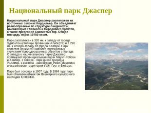
Jasper National Park Jasper National Park is located on the eastern slopes of the Cordillera. It combines the landscapes of the highlands of the Main and Front Ranges, which are diverse in structure, as well as the foothills of the Rocky Mountains. The total area of the park is 10750 sq. km. The park is located 320 km. west of the city of Edmonton (capital of the province of Alberta) and 290 km. northwest of the city of Calgary. The park is one of the most visited conservation sites in Canada by tourists. Mount Robson and Humber Provincial Parks adjoin Jasper National Park from the west, and the park from the north wildlife Willmore, to the east are the Rocky Mountains Preserve and the White Goat and Bighorn Protected Areas. The park was founded in 1907. In 1984, the park was declared a UNESCO World Heritage Site. The park is located 320 km. west of the city of Edmonton (capital of the province of Alberta) and 290 km. northwest of the city of Calgary. The park is one of the most visited conservation sites in Canada by tourists. Jasper National Park is bordered by Mount Robson and the Humber Provincial Parks to the west, Willmore Wildlife Park to the north, and Rocky Mountains Preserve and the White Goat and Bighorn Protected Areas to the east. The park was founded in 1907. In 1984, the park was declared a UNESCO World Heritage Site.
slide number 8

Description of the slide:
Yosemite National Park Yosemite National Park (USA, California) was created in 1890 thanks to the tireless efforts of naturalist John Muir. In 1890, the US Congress declared it a nature reserve, and already in 1864, Congress awarded Yosemite Valley in California the status of a public park. In our time at the top of the season Yosemite park teeming with people. Every year, the beauty of the park attracts four million visitors. The management of the reserve strives to preserve the pristine nature of this region, and not to forget about tourists. Nowadays, at the peak of the season, Yosemite Park is teeming with people. Every year, the beauty of the park attracts four million visitors. The management of the reserve strives to preserve the pristine nature of this region, and not to forget about tourists.
slide number 9
Description of the slide:
slide number 10
Description of the slide:
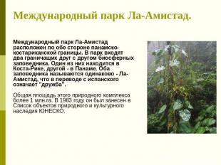
La Amistad International Park. La Amistad International Park is located on both sides of the Panamanian-Costa Rican border. The park includes two biosphere reserves bordering each other. One of them is in Costa Rica, the other is in Panama. Both reserves are called the same - La Amistad, which means "friendship" in Spanish. The total area of this natural complex is more than 1 million hectares. In 1983, it was included in the UNESCO List of Natural and Cultural Heritage Sites.
slide number 11

Description of the slide:
Corcovado National Park (Costa Rica) Corcovado National Park is a beautiful piece of nature in the south of Costa Rica. It is located on the Osa Peninsula, on the Pacific coast. The area of the park is 54,000 hectares. The magnificence of the nature of this remote, almost untouched forest in Central America, the diversity of its flora and fauna attracts the attention of people. There are at least eight ecosystems on the territory of Corcovado. About 500 species of trees grow in the park, the largest of which is the cotton tree. Reaching a diameter of three meters, it rises more than 70 meters. Corcovado can see almost 400 species of feathered inhabitants. The park is home to the largest population of red macaws in the country.
slide number 12

Description of the slide:
Monteverde National Park (Costa Rica) In the 1960s, a group of scientists and local residents founded the Cloud Forest Reserve in Monteverde, which eventually included the watershed zone. Since then, the reserve has been expanded several times, and now it covers approximately 10,500 hectares. This reserve is one of the most attractive places in Costa Rica. Every year, about 50,000 tourists climb the steep, winding dirt road to reach Monteverde. Numerous bird lovers and naturalists come here to observe all kinds of birds, animals and plants that have found refuge in the reserve and nearby areas.
slide number 13

Description of the slide:
slide number 14
Description of the slide:
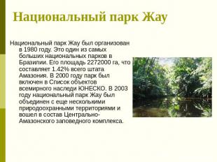
Zhau National Park Zhau National Park was organized in 1980. This is one of the largest national parks in Brazil. Its area is 2272000 hectares, which is 1.42% of the entire Amazon state. In 2000, the park was included in the UNESCO World Heritage List. In 2003, the Jau National Park was merged with several other protected areas and became part of the Central Amazonian Reserve Complex.
slide number 15

Description of the slide:
Chaco National Park Chaco National Park is located in the central part of the South American continent, in the east of the Gran Chaco plain. This name can be translated as "Big hunting field". Chaco Park was founded in 1954. The park was established by the Argentine government to protect the unique landscapes of the most elevated parts of the Eastern Chaco.
slide number 16
Description of the slide:
Los Glaciares National Park Los Glaciares National Park covers an area of almost 446 thousand hectares (according to some sources, 760 thousand hectares). The park is the second largest conservation site in Argentina. It is located along the Chilean border in the province of Santa Cruz south of the 50th parallel. For the first time, the territory between the lakes Viedma and Lago Argentino was taken under protection by the Argentine state in 1937. However, this territory was declared a national park only shortly before the end of World War II in April 1945. Modern borders Los Glaciares National Park were statutorily established only in the autumn of 1971. In 1981, Los Glaciares National Park was inscribed on the List of Natural World Heritage Sites. Over 40 percent of the national park is covered eternal ice constituting the so-called Southern Patagonian Ice Sheet. Powerful valley glaciers diverge from this shield to the west and east. In the east (in Chile), the "ends" of these glaciers descend into Pacific Ocean. In Argentina, most glacial tongues end in large lakes.
slide number 17

Description of the slide:
Manu Manu National Park is one of the oldest major tropical parks in the world. Manu National Park was established on May 29, 1973. 14 years later (in 1987) it was recognized as a UNESCO World and Natural Heritage Site, and also received the status of a biosphere reserve. Manu National Park is located in the southeast of Peru, 1400 km from the capital (Lima). The total area of the reserve is 1.9 million hectares. The park is divided into three zones: the national park itself, the reserve and the cultural zone. The main purpose of the creation of the Manu National Park is the conservation of tropical biodiversity.
slide number 18

Description of the slide:
Paracas National Park Paracas National Park. It is located about 250 kilometers south of Lima, on the path of the Pan American Highway. The Paracas National Park covers 335,000 hectares of coastline and the Paracas Peninsula. It was formed in 1975 by the Peruvian government with the aim of preserving the many animals that live here and migrate annually. He cultivates respect for environment and contributes to the development of tourism. It was here that more than 100 archaeological sites- evidence of the centuries-old culture of Paracas. Coastal waters are home to sea lions, cat otters, dolphins, over 200 bird species and 4 species of sea turtles.
slide number 19

Description of the slide:
slide number 20

Description of the slide:
Virunga Virunga National Park is one of the oldest national parks in Africa. It is located in the northeast of the Democratic Republic of the Congo. For 300 kilometers, the border of the park coincides with the state borders of Rwanda and Uganda. The official birth year of Virunga Park is 1929. Then it was named Albert and Kivu National Park. In 1969, a separate Virunga National Park was separated from the Albert and Kivu single conservation area. Currently, the territory of the park borders on the lands of the Ruwenzori National Park in Uganda and the Volcanoes National Park in Rwanda. The area of the Virunga National Park is 790 thousand hectares. Landscapes in the national park are very diverse. Here you can find grassy and tree savannahs, low-growing permanently wet forests, bamboo thickets, swamps, meadows, glaciers, snowfields and extensive lava plateaus. The territory of the park is stretched from north to south and consists of three different parts. The northern part includes the Rwenzori mountains and the Semliki valley, in the center are Lake Eduard and the plains of Rvindi, Rutshuru and Ishasha. southern part- the lava plateaus of Nyamlagira and Nyaragongo, as well as part of the Virunga volcanic massif.
slide number 21

Description of the slide:
Air and Tenere Reserve The Air and Tenere Nature Reserve is located on the southern border of the Sahara Desert. Its area is 77000 sq. km. The reserve was founded in 1988. Immediately, about 15% of its territory was allocated to a special reserve with a strict protection regime to protect the addax antelope. In 1991, the reserve was included in the list of UNESCO World Natural and Cultural Heritage Sites. There are many interesting geological monuments on the Air Plateau. Both the plateau and mountain ranges are dissected by deep valleys. However, only temporary streams flow here, which come to life only for a short time after the rains. The climate of the reserve is typical for the Central Sahara: very hot and dry. Nowhere in the reserve does more than 100 mm of precipitation fall annually.
slide number 22

Description of the slide:
Serengeti National Park The Serengeti National Park is located on the African Great Rift. It is included in the list of the most famous national parks in the world. The Serengeti National Park is a 30,000 square kilometer low-grass hilly valley in Tanzania and Kenya. They are covered with juicy grass, which grows well on fertile soil of volcanic origin. The Serengeti is an animal paradise that delights everyone who visits it.
slide number 23

Description of the slide:
Nairobi National Park Just seven kilometers from the capital of Kenya, there is a small savannah with tall grass and rare sprawling trees - Nairobi National Park, with a total area of only 117 square meters. km. This park was opened before many similar parks in Kenya, in 1946. This is one of the few parks in the world where you can simultaneously enjoy the beauty of almost untouched wildlife and not lose sight of the silhouette. big city. The fauna and flora of the Nairobi National Park is so diverse that you might think that you are in the heart of wild Africa, and not on the outskirts of a multi-million city. In the park you can see lions, rhinos, cheetahs, antelopes, giraffes, gazelles. The Athi River flows there, in the waters of which there are crocodiles and hippos, and in the coastal forests - birds and monkeys. About 400 different bird species have been recorded in Nairobi National Park. One of the features of the park is a large number of rhinos living in it, about 50 individuals. Here, unlike other parks and reserves, you can almost always see the black rhinoceros in its natural habitat. In the national park there is also a shelter-cure for the wounded and sick animals.
slide number 24

Description of the slide:
Kilimanjaro National Park Kilimanjaro National Park was founded in 1973 and now occupies 756 square meters. km. The foot of the mountain is at 1829 m above sea level and Kibo Peak is at 5895 m. Kilimanjaro National Park was inscribed on the World Heritage List in 1987. Mount Kilimanjaro is the highest single mountain in the world. Mount Kilimanjaro was formed as a result of a series of volcanic movements. As a result of volcanic activity, three peaks were formed - Shira, Kibo and Mawenzi.
slide number 27

Description of the slide:
Fiordland National Park ( New Zealand) New Zealand is one of the most environmentally friendly corners of the Earth. A third of the country's area (more than 5 million hectares) is protected areas. New Zealand has 14 national parks. On the south island is the largest national park in New Zealand - Fiordland. The park is located in the northwestern part of the island. The length of the park is 230 km, the total area is 1200 thousand hectares. Fiordland National Park was founded in 1952. It is currently included in the UNESCO World Heritage List.
slide number 28

Description of the slide:
slide number 29

Description of the slide:
Vanoise National Park The Vanoise National Park is the first national park in France. It was founded in 1963. The reason for the creation of the park was the threat of complete extermination of stone goats in this area. Definitely, Vanoise can be called the main national park of France. Vanoise National Park is located to the south mountain range Mont Blanc and extends along the Alps mountain range in the Savoie region. This is a relatively small park. The park is divided into two zones: the central one has a length of 528 sq. km. and peripheral zone - 1450 sq. km. The peripheral zone is the area that surrounds the central one; it was created to protect wildlife in the central zone in order to preserve it in its original form. The Peripheral Zone makes it possible to further restrict people's access to these beautiful wild lands. For 14 kilometers, the Vanoise National Park borders on the Italian Gran Paradiso National Park. Both parks form the largest protected area Western Europe
Description of the slide:
Coto de Doñana National Park Spain's legendary 50,000-hectare Doñana National Park serves as a spring bird airport that welcomes hundreds of thousands of birds from Africa to Europe, stopping in these swampy woodlands to nest and breed. .
slide number 32

Description of the slide:
Thingvellir National Park Thingvellir National Park was created by decree of the Icelandic Parliament in 1928. This is the very first protected area in Iceland. It is also one of the oldest national parks in Europe. During the 20th century, the territory of the park was expanded several times. The last time the boundaries of the national park were changed in 2004.
slide number 33

Description of the slide:
National Park Belovezhskaya Pushcha The National Park "Belovezhskaya Pushcha" is located on the territory of the Kamenets and Pruzhany districts of the Brest region and the Svisloch district of the Grodno region. The administrative center of the national park is located in the village of Kamenyuki, Kamenetsky district. The State National Park "Belovezhskaya Pushcha", located on the territory of the Republic of Belarus, is a single natural complex with the Belovezhskaya Pushcha National Park of the Republic of Poland. The area of the national park is 87,363 ha on the Belarusian side; from the Polish - 10,501 ha. Belovezhskaya Pushcha is the only one in Europe preserved in its natural state large array old-age forests of the Western European type with elements of the western, northern and southern flora. The fauna of the National Park "Belovezhskaya Pushcha" is rich and diverse. Its territory is inhabited by 59 species of mammals (including 6 protected ones), 253 species of birds, 11 species of amphibians, 7 species of reptiles, 24 species of fish and more than 11,000 species of invertebrates.
slide number 34
Description of the slide:
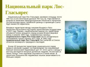
Paanajärvi National Park Paanajärvi National Park is located in the north-west of the Republic of Karelia, in its most elevated part. The Paanajärvi National Park was established on May 20, 1992 by Decree of the Government of the Russian Federation No. 331. The area of the national park is 104,473 hectares. Vegetable world- the main attraction of the park. Its originality is determined by three factors - the low-mountain nature of the relief, the presence of carbonate rocks (dolomites) favorable for the growth of many calciphilous plants, and, finally, the presence of large natural massifs untouched by man. 217 species of vertebrates are registered in the area of the national park: 36 species of mammals, 160 species of birds, 3 species of amphibians and reptiles, 17 species of fish and 1 species of cyclostomes. The pearl of the park is Lake Paanajärvi, characterized by its small size (1.5 by 24 km) and exceptional depth (128 m). There are many rapids on the rivers, there are significant waterfalls. Reservoirs abound with valuable species of fish.
slide number 35

Description of the slide:
slide number 36
Description of the slide:
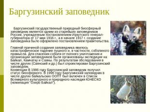
Barguzinsky Reserve The Barguzinsky State Natural Biosphere Reserve is one of the oldest reserves in Russia, established by a decree of the Irkutsk Governor-General dated May 17, 1916, and in early 1917 the creation of the reserve was formalized by a government decree. The main reason for the creation of the reserve was the catastrophic decline of fur and, in particular, sable trade. Expeditions to Lake Baikal, Kamchatka and the Sayan mountains were organized to save the sable from complete destruction and organize reserves. According to the results of the survey, among others (Sayansky and others), the Barguzinsky Reserve was designed. Conventions In 1986, the Barguzinsky Reserve received the status of a biosphere reserve. In 1996, the Barguzinsky Reserve, along with other Baikal protected areas, was included in the UNESCO World Cultural and Natural Heritage List (nomination "Lake Baikal").
Description of the slide:
Sagarmatha Sagarmatha is an outstanding natural landscape comprising highlands, glaciers and deep gorges dominated by highest peak world - Mount Everest (8848 m). The park is home to several rare animal species, including the snow leopard and red panda. The unique culture of the local population - the Sherpas - also draws attention to this area.
slide number 39

Description of the slide:
Komodo National Park Komodo National Park is located in the center of the Indonesian archipelago, between the islands of Sumbawa and Flores. The territory of the national park contains 603 square kilometers of land and 1,214 square kilometers of turquoise sea waters. The park includes three main islands: Komodo, Rinka and Padar, as well as many small islands with a total area of 1817 kilometers, which are also part of the Lesser Sunda Islands. This national park has several beautiful exotic islands coupled with rich coastal and wild marine nature. Its unique wide biodiversity has made it the most popular park in Indonesia.


