The problem of the Kuril Islands in relations between Russia and Japan. Natural resources of the Kuril Islands
Kurile Islands
If you look at the map of Russia, then in fact Far East, between Kamchatka and Japan, you can see a chain of islands, which are the Kuril Islands. The archipelago forms two ridges: the Greater Kuril and the Lesser Kuril. The Great Kuril Ridge includes about 30 islands, as well as a large number of small islands and rocks. The Small Kuril Ridge stretches parallel to the Big one. It includes 6 small islands and many rocks. At the moment, all the Kuril Islands are controlled by Russia and are included in its Sakhalin region, some of the islands are the subject of a territorial dispute between Russia and Japan. The Kuril Islands are administratively part of Sakhalin region. They are divided into three districts: Severokurilsky, Kurilsky and Yuzhno-Kurilsky.
The Kuril Islands, which are an area of active volcanic activity. A significant role in the formation of the relief of the islands is played by sea terraces of different heights. Coastline abounds in bays and capes, the coasts are often rocky and steep, with narrow boulder-pebble, less often sandy beaches. Volcanoes are located almost exclusively on the islands of the Greater Kuril Ridge. Most of these islands are active or extinct volcanoes, and only the northernmost and southernmost islands are composed of sedimentary formations. Most of the volcanoes Kuril Islands originated directly on the seabed. The Kuril Islands themselves are the peaks and ridges of a solid still hidden under water. mountain range. The Great Kuril Ridge is a remarkable and vivid example of the formation of a ridge on the earth's surface. There are 21 known active volcanoes on the Kuril Islands. The most active volcanoes of the Kuril ridge include Alaid, Sarychev Peak, Fuss, Snow and Milna. Attenuated volcanoes, which are in the solfataric stage of activity, are located mainly in the southern half of the Kuril chain. There are many on the Kuril Islands extinct volcanoes Atsonupuri Aka Roko and others.
The climate of the Kuril Islands is moderately cold, monsoonal. It is determined by their location between two huge bodies of water - the Sea of Okhotsk and the Pacific Ocean. The average temperature in February is from -5 to -7 degrees C. The average temperature in August is from 10 degrees C. The features of the monsoon climate are more pronounced in the southern part of the Kuril Islands, which is more influenced by the Asian continent cooling in winter, from which cold and dry western winds. Only the climate of the southernmost islands is somewhat mitigated by the warm Soya current fading here.
Significant amounts of precipitation and a high runoff coefficient favor the development of a dense network of small streams on the islands. In total, there are more than 900 rivers here. The mountainousness of the islands also determines the steep slope of the rivers and the high speed of their flow; rapids and waterfalls are frequent in the riverbeds. Rivers of the flat type are a rare exception. The main food of the river is received from rains, snow nutrition also plays a significant role, especially from snowfields occurring in the mountains. Only slowly flowing streams within the flat areas are covered with ice every year. The water of many rivers is undrinkable due to high salinity and high sulfur content. There are several dozen lakes of various origins on the islands. Some of them are related to volcanic activity.
On the Kuril Islands there are 1171 species of only vascular plants belonging to 450 genera and 104 families. There are 49 species of trees, including 6 conifers, 94 species of shrubs, including 3 conifers, 11 species of woody lianas, 9 species of shrubs, 5 species of bamboo, 30 species of evergreens, including 7 coniferous and 23 deciduous species. In respect of the richest is Kunashir, where 883 species grow. There are somewhat fewer species on Iturup (741) and Shikotan (701). The terrestrial invertebrate fauna of the South Kuril Islands is unique and far from being fully explored. Here passes the northern border of the distribution of a huge number of species found in addition to the South Kuriles in Japan, Korea and China. In addition, the Kuril species are represented by populations adapted to the peculiar insular conditions of existence. The insect fauna of the southern part of the Kuril archipelago is closer to the fauna of Hokkaido.
The permanent population of the islands lives mainly on southern islands- Iturup, Kunashir, Shikotan and northern - Paramushir, Shumshu. The basis of the economy is the fishing industry, because. the main natural wealth is the biological resources of the sea. Agriculture due to unfavorable natural conditions, has not developed significantly. The population today is about 8,000 people. The number of employees has steadily increased in recent years and reached 3,000 in 2000. The bulk of the population is employed in industry. In recent years, the birth rate has slightly exceeded the death rate. Natural population decline has been replaced by natural population growth. The migration balance is also negative.
The problem of ownership of the southern Kuril Islands is a territorial dispute between Japan and Russia, which Japan considers unresolved since the end of World War II. After the war, all the Kuril Islands came under the administrative control of the USSR, but a number of the southern islands are disputed by Japan. The Kuril Islands are of great geopolitical and military-strategic importance for Russia and affect the national security of Russia. On the way to solving the problem of the Kuril Islands, our country still has to go through a lot of discussions and disputes, but the only key to mutual understanding between the two countries is the creation of a climate of trust.
Geographical position
On the border Sea of Okhotsk and the Pacific Ocean, between the island of Hokkaido and the Kamchatka Peninsula, lies the Kuril archipelago.1 The archipelago forms two ridges: the Greater Kuril and the Lesser Kuril. The Great Kuril Ridge stretches for almost 1,200 km between 43 degrees 39 minutes (Cape Veslo on the island of Kunashir) and 50 degrees 52 minutes north (Cape Kurbatov on the island of Shumshu). The ridge includes about 30 islands (the largest of them are Kunashir, Iturup, Urup, Simushir, Onekotan, Paramushir and Shumshu), as well as a large number of small islands and rocks. The Lesser Kuril Ridge stretches parallel to the Greater Ridge for 105 km between 43 degrees 21 minutes and 43 degrees 52 minutes north latitude. It includes 6 small islands (the largest of them is Shikotan) and many rocks. The total area of the Kuril Islands is 15.6 thousand square meters. km. The length is 1175 km. The area is 15.6 thousand km². Coordinates: 46°30? with. sh. 151°30? in. d.? / ?46.5° N sh. 151.5° E e. They are of great military-strategic and economic importance. Includes 20 large and more than 30 small islands. List of islands from north to south:
northern group:
Shumshu Atlasov Island (Alaid)
Paramushir
Antsiferov Island
Middle group:
Macanrushi
Avos Rocks
· Onekotan
Harimkotan
· Chirinkotan
Shiashkotan
· Trap Rocks
Raikoke
· Medieval rocks
Ushishir Islands
Ryponkicha
Simushir
Broughton Island
The Black Brothers
Brother Chirpoev
Southern group:
Kunashir
Small Kuril Ridge
Shikotan
Islands of the South Kuril chain
Polonsky Island
· Shard Islands
Green Island
Tanfiliev Island
Yuri Island
Demin Islands
Anuchin Island
Signal Island
At the moment, all the Kuril Islands are controlled by Russia and are included in its Sakhalin region, some of the islands are the subject of a territorial dispute between Russia and Japan.
Administrative division
The Kuril Islands are administratively part of the Sakhalin Oblast. They are divided into three districts: North Kuril, Kuril and South Kuril. The centers of these regions have the corresponding names: Severo-Kurilsk, Kurilsk and Yuzhno-Kurilsk. And there is another village - Malo-Kurilsk (the center of the Lesser Kuril Ridge). There are four Kurils in total. At present, the Sakhalin Region includes 25 municipalities: 17 urban districts and 2 municipal districts, on the territory of which there are 3 urban settlements and 3 rural settlements.
History of the islands
Before the arrival of the Russians and the Japanese, the islands were inhabited by the Ainu. In their language, “kuru” meant “a person who came from nowhere,” from which their second name “smokers” came, and then the name of the archipelago. In Russia, the first mention of the Kuril Islands dates back to 1646. The first Russian settlements of that time are evidenced by Dutch, German and Scandinavian medieval chronicles and maps. In 1644, a map was drawn up, on which the islands were designated under the collective name "thousand islands". Then, in 1643, the islands were explored by the Dutch, led by Marten Fiers. This expedition was over detailed maps and described the land.
18th century
In 1738-1739, Martyn Spanberg walked along the entire ridge, putting the islands he met on the map. In the future, the Russians, avoiding dangerous voyages to the southern islands, mastered the northern ones. Great success was achieved by the Siberian nobleman Antipov with the Irkutsk translator Shabalin. They managed to win the favor of the Kuril people, and in 1778-1779 they managed to bring into citizenship more than 1500 people from Iturup, Kunashir and even Matsumaya (now Japanese Hokkaido). In the same 1779, Catherine II by decree freed those who accepted Russian citizenship from all taxes. But relations were not built with the Japanese: they forbade the Russians to go to these three islands. In the "Extensive land description of the Russian state ..." of 1787, a list of the 21st island belonging to Russia was given. It included the islands up to Matsumai, whose status was not clearly defined, since Japan had a city in its southern part. At the same time, the Russians had no real control even over the islands south of Urup. There, the Japanese considered the Kuriles to be their subjects.
19th century
In 1805, a representative of the Russian-American Company, Nikolai Rezanov, who arrived in Nagasaki as the first Russian envoy, tried to resume negotiations on trade with Japan. But he also failed. However, the Japanese nobles, who were not satisfied with the despotic policy of the supreme power, hinted to him that it would be nice to carry out a forceful action in these lands, which could push the situation off the ground. This was carried out on behalf of Rezanov in 1806-1807 by an expedition of two ships. Ships were plundered, a number of trading posts were destroyed, and a Japanese village was burned on Iturup. Later they were tried, but the attack for a while led to a serious deterioration Russo-Japanese relations.
20th century
February 2, 1946. Decree of the Presidium of the Supreme Soviet of the USSR on the inclusion of South Sakhalin and the Kuril Islands in the RSFSR.
1947. Deportation of Japanese and Ainu from the islands to Japan. Displaced 17,000 Japanese and an unknown number of Ainu.
November 5, 1952. A powerful tsunami hit the entire coast of the Kuriles, Paramushir suffered the most. giant wave washed away the city of Severo-Kurilsk.
Where did such unusual, exotic names come from? The term "Kuril Islands" is of Russian-Ainu origin. It is related to the word "kur", which means "man". At the very end of the 17th century, Kamchatka Cossacks for the first time called the inhabitants of the south of Kamchatka (Ainu) and the then unknown southern islands "Kurils". Peter I became aware in 1701-1707. about the existence of the "Kuril Islands", and in 1719 "Kuril Land" was for the first time clearly marked on the map by Semyon Remizov. Any suggestions that the name of the archipelago was given by "smoking" volcanoes belong to the realm of legends.
These are the words of the Ainu language: Paramushir - wide island, Onekotan - old settlement, Ushishir - land of bays, Chiripoy - birds, Urup - salmon, Iturup - big salmon, Kunashir - black island, Shikotan - the best place. Beginning in the 18th century, the Russians and the Japanese tried to rename the islands in their own way. Most often used serial numbers - the first island, the second, etc.; only the Russians counted from the north, and the Japanese from the south.
Relief
The Kuril Islands, which are an area of active volcanic activity, are two parallel underwater ridges, which above the ocean level are expressed by a chain of islands of the Greater and Lesser Kuril ridges.
The relief of the first is predominantly volcanic. There are more than a hundred volcanoes here, of which more than 40 are active. Volcanic structures often merge at their bases and form narrow, ridge-like, with steep (usually 30-40°) ridges, elongated mainly along the strike of the islands. Often volcanoes rise in the form of isolated mountains: Alaid - 2339m, Fussa - 1772m, Milna - 1539m, Bogdan Khmelnitsky - 1589m, Tyatya - 1819m. The heights of other volcanoes, as a rule, do not exceed 1500m. Volcanic massifs are usually separated by low isthmuses, which are composed of Quaternary marine deposits or volcanic-sedimentary rocks of the Neogene age. The forms of volcanoes are different. There are volcanic structures in the form of regular and truncated cones; often in the crater of an older truncated cone rises a young one (Krenitsyn volcano on Onekotan Island, Tyatya volcano on Kunashir). Calderas are widely developed - giant cauldron-shaped failures. They are often flooded by lakes or the sea and form huge deep-water (up to 500 m) bays (Broughton on Simushir Island, Lion's Mouth on Iturup).
A significant role in the formation of the relief of the islands is played by sea terraces of different heights: 25-30 m, 80-120 m and 200-250 m. .
The Small Kuril Ridge, slightly protruding on the day surface, in northeast direction continues in the form of an underwater ridge Vityaz. It is separated from the bed of the Pacific Ocean by the narrow Kuril-Kamchatka deep-water (10542 m) trench, which is one of the deepest-water trenches in the world. There are no young volcanoes on the Lesser Kuril Ridge. The islands of the ridge are flat, sea-lined land areas, rising above ocean level by only 20-40 m. The exception is the most big Island ridges - Shikotan, which is characterized by low-mountain (up to 214 m) relief, formed as a result of the destruction of ancient volcanoes.
Geological structure
On the territory of the Kuril Islands, formations of the Cretaceous, Paleogene, Neogene and Quaternary periods come to the surface within two garlands of islands: Bolshekurilskaya and Malokurilskaya. tuff sandstones, tuff siltstones, tuff gravelstones, sandstones, siltstones, mudstones are noted on the islands of the Lesser Kuril Ridge. Volcanic, volcanogenic-sedimentary, sedimentary deposits of the Neogene and Quaternary age, intruded by numerous relatively small extrusive and subvolcanic bodies and dikes of a wide petrographic range, from basalts and dolerites to rhyolites and granites, take part in the geological structure of the Greater Kuril ridge. The territory of Sakhalin and the Kuril Islands and the adjacent water area of the Sea of Japan and the Sea of Okhotsk is part of the transition zone from the continent to the ocean, entering the northwestern segment of the Pacific mobile belt. The western part of this region belongs to the Khokkaido-Sakhalin geosynclinal-folded system, and the eastern part belongs to the Kuril-Kamchatka geosynclinal-island-arc system of the folded-block structure. The main difference between these systems lies in the Cenozoic history of development: in the Khokkaido-Sakhalin system, sedimentation processes prevailed in the Cenozoic, and volcanism occurred sporadically in local structures: the Kuril-Kamchatka system at that time developed in the mode of an active volcanic arc, which left an imprint on the composition of the formed here structural-material complexes. Cenozoic deposits were the first to fold into folds; formations of this age in the Kurile-Kamchatka system underwent block dislocations, and folded structures are not typical for them. Significant differences are also noted in the pre-Cenozoic formations of the two tectonic systems. The structures of the first order for both systems are troughs and uplifts that developed throughout the Cenozoic. The formation of the structural plan of the region was largely determined by faults.
Minerals
On the islands and in the coastal zone, industrial reserves of non-ferrous metal ores, mercury, natural gas, oil.2On the island of Iturup, in the area of the Kudryavy volcano, there is the only known deposit of rhenium in the world. Here, at the beginning of the 20th century, the Japanese mined native sulfur. The total resources of gold in the Kuril Islands are estimated at 1,867 tons, silver - 9,284 tons, titanium - 39.7 million tons, iron - 273 million tons. Currently, the development of minerals is not numerous.
Volcanism
Volcanoes are located almost exclusively on the islands of the Greater Kuril Ridge. Most of these islands are active or extinct volcanoes, and only the northernmost and southernmost islands are composed of sedimentary formations. These layers of sedimentary rocks on the mentioned islands were the foundation on which volcanoes arose and grew. Most of the volcanoes of the Kuril Islands arose directly on the seabed. The relief of the seabed between the Kamchatka Peninsula and the island of Hokkaido is a steep ridge with bottom depths of about 2,000 m towards the Sea of Okhotsk, and near the island of Hokkaido even more than 3,300 m and with depths of more than 8,500 m towards the Pacific Ocean. As you know, directly southeast of the Kuril Islands is one of the deepest oceanic depressions, the so-called Tuscarora depression. The Kuril Islands themselves are the peaks and ridges of a solid mountain range hidden still under water. The Great Kuril Ridge is a remarkable and vivid example of the formation of a ridge on the earth's surface. Here one can observe a bend in the earth's crust, the crest of which rises 2–3 km above the bottom of the Sea of Okhotsk and 8–8.5 km above the Tuskarora depression. Faults formed at this bend along its entire length, along which fiery-liquid lava broke through in many places. It was in these places that volcanic islands Kuril ridge. Volcanoes poured out lava, threw out mass volcanic sand and debris that settled nearby in the sea, and it became and becomes smaller and smaller. In addition, the bottom itself, due to various geological reasons, can rise, and if such a geological process continues in the same direction, then after millions of years, and maybe after hundreds of thousands, a continuous ridge will form here, which, on the one hand, will connect Kamchatka with Hokkaido, and on the other hand, it will completely separate the Sea of Okhotsk from the Pacific Ocean. The volcanoes of the Kuril ridge are located on arcuate faults, which are a continuation of the faults of Kamchatka. Thus, they form one volcanic and tectonic Kamchatka-Kuril arc, convex towards the Pacific Ocean and directed from the southwest to the northeast. The activity of volcanoes on the Kuril Islands in the past and at present is very intense. There are about 100 volcanoes here, of which 40 are active and are in the solfataric stage of activity. Initially, volcanoes arose in the Upper Tertiary on the extreme southwestern and northeastern islands of the Kuril chain, and then they moved to its central part. Thus, volcanic life on them began quite recently, only one or a few million years, and continues to this day.
active volcanoes
21 active volcanoes are known on the Kuril Islands, of which five stand out for their more active activity, among the most active volcanoes of the Kuril ridge, these include Alaid, Sarychev Peak, Fuss, Snow and Milna. Among the active volcanoes of the Kuril Islands, the most active volcano is Alaid. It is also the highest among all the volcanoes of this ridge. As a beautiful cone-shaped mountain, it rises directly from the sea surface to a height of 2,339 m. At the top of the volcano there is a small depression, in the middle of which the central cone rises. It erupted in 1770, 1789, 1790, 1793, 1828, 1829, 1843 and 1858, that is, eight eruptions in the last 180 years. As a result of the last eruption, a volcanic island with a wide crater was formed, called Taketomi. It is a side cone of the Alaid volcano.
Sarychev Peak is in second place in terms of the intensity of volcanic activity and is a stratovolcano located on Matua island. It has the form of a two-headed cone. On the high (1497 m) peak there is a crater with a diameter of about 250 m and a depth of about 100 - 150 m. There are many cracks near the crater on the outer side of the cone, from which white vapors and gases were emitted (August and September 1946). To the southeast of the volcano are, apparently, small secondary cones. Starting from the 60s of the XVIII century to the present, its eruptions occurred in 1767, around 1770, around 1780, in 1878-1879, 1928, 1930 and 1946. In addition, there are numerous data on its fumarolic activity. So in 1805, 1811, 1850, 1860. he "smoked". In 1924, an underwater eruption occurred near it. Thus, over the past 180 years, there have been at least seven eruptions. They were accompanied by both explosive activity and outpourings of basaltic lava.
The Fussa Peak Volcano is located on the island of Paramushir and is a free-standing beautiful cone, the western slopes of which steeply break into the Sea of Okhotsk. Fuss Peak erupted in 1737, 1742, 1793, 1854 and 1859, and the last eruption, i.e., 1859, was accompanied by the release of asphyxiating gases.
Snow Volcano is a small low domed volcano, about 400 m high, located on Chirpoi Island. At its top there is a crater about 300 m in diameter. Apparently, it belongs to the shield volcanoes. An indication without an exact date is known about the eruption of this volcano in the 18th century. In addition, Snow volcano erupted in 1854, 1857, 1859 and 1879.
Volcano Miln is located on the island of Simushir, is a two-headed volcano with an inner cone 1526m high. Lava flows are visible on the slopes, which in places protrude into the sea in the form of huge lava fields. There are several side cones on the slopes. There is information about the volcanic activity of the Milna volcano dating back to the 18th century. According to more accurate information, it erupted in 1849, 1881 and 1914. Less active volcanoes include Severgin, Sinarka, Raikoke and Medvezhiy volcanoes.
fading volcanoes
Attenuated volcanoes, which are in the solfataric stage of activity, are located mainly in the southern half of the Kuril chain. Only the intensely smoking Chikurachki volcano, 1817 m high, located on the island of Paramushir, and the Ushishir volcano, located on island of the same name, are located in the northern half of the ridge. Ushishir volcano (400 m) the edges of its crater form a ring-shaped ridge, destroyed only on the south side, due to which the bottom of the crater is filled with sea. Black Volcano (625 m) is located on the Black Brothers Island. It has two craters: one at the top, with a diameter of about 800 m, and the other is a fissured shape on the southwestern slope.
Extinct volcanoes
There are many extinct volcanoes of various shapes on the Kuril Islands - cone-shaped, dome-shaped, volcanic massifs, the “volcano in a volcano” type. Among the cone-shaped volcanoes, Atsonupuri, 1206 m high, stands out for its beauty. It is located on the island of Iturup and is a regular cone; on its top there is an oval-shaped crater, about 150 m deep. The following volcanoes also belong to the cone-shaped volcanoes: Aka (598 m) on the island of Shiashkotan; Roko (153m), located on the island of the same name near Brat Chirpoev Island (Black Brothers Islands); Rudakov (543m) with a lake in the crater, located on the island of Urup, and Bogdan Khmelnitsky volcano (1587m), located on the island of Iturup. Dome-shaped volcanoes are Shestakov (708 m), located on the island of Onekotan, and Broughton - 801 m high, located on the island of the same name. Volcanic massifs include Ketoi volcano - 1172 m high, located on the island of the same name, and Kamuy volcano - 1322 m high, located in the northern part of Iturup Island. The “volcano within a volcano” type includes: Krenitsyn Peak on Onekotan Island.
Climate
The climate of the Kuril Islands is determined by their location between two huge bodies of water - the Sea of Okhotsk and the Pacific Ocean. The climate of the Kuril Islands is moderately cold, monsoonal. The average temperature in February (the coldest month on the islands) is from -5 to -7 degrees C. The average temperature in August is from 10 degrees C in the north to 16 degrees C in the south. Precipitation for the year falls 1000-1400 mm. The features of the monsoon climate are more pronounced in the southern part of the Kuril Islands, which is more influenced by the Asian continent, which cools in winter, from which cold and dry westerly winds blow. Winter in the south is cold, with frosts down to -25°. In the north, winters are milder: frosts reach only -16 °. The northern part of the ridge is in winter under the influence of the Aleutian baric minimum; cyclonic activity develops along its western periphery, with which storm winds and significant precipitation are associated. Sometimes up to 1.5 m of snow falls per day. The action of the Aleutian minimum weakens towards June and fades in July-August. The sea waters surrounding the islands heat up more slowly in summer than land, and the winds blow through the Kuril chain from the ocean to the mainland. They carry a lot of water vapor, the weather becomes cloudy, foggy (due to the temperature difference between cold sea masses and warming land). Dense fogs persist for weeks; cloudiness prevents the heating of the sea and islands by the sun's rays. However, in summer there is not such a noticeable increase in precipitation as in the continental monsoon region of the Far East, since a lot of precipitation also falls in winter. For three summer months, they fall only 30-40% of the annual amount, equal to 1000-1400 mm. The average temperature of the warmest month - August - from 10 ° in the north to 17 ° in the south. In September, the action of the Aleutian low again intensifies, in connection with which prolonged drizzling rains begin in the northern half of the Kuril arc. In the south, monsoon rains are replaced by good weather, occasionally disturbed by typhoons. The general severity of the climate of the Kuril Islands is due not only to the low temperatures of the waters of the neighboring Sea of Okhotsk, but also to the influence of the cold Kuril Current, which washes the island ridge from the east. Only the climate of the southernmost islands is somewhat mitigated by the warm Soya current fading here.
Water resources
Significant amounts of precipitation and a high runoff coefficient favor the development of a dense network of small streams on the islands. In total, there are more than 900 rivers here. Due to the mountainous surface of the islands, the surface runoff is divided into numerous small drainage basins, forming a system of streams spreading from the central heights. The mountainousness of the islands also determines the steep slope of the rivers and the high speed of their flow; rapids and waterfalls are frequent in the riverbeds. Rivers of the flat type are a rare exception. Approaching the sea, some rivers rush down waterfalls from high cliffs, others go out onto a flat, sandy or swampy coast; at the mouths of these rivers there are often shallow bars, pebble spits and embankments that block the entry of boats into the rivers even at high tide. The main food of the river is received from rains, snow nutrition also plays a significant role, especially from snowfields occurring in the mountains. Rivers flood in spring and after heavy rains in summer. Mountain rivers are covered with ice not every year, and waterfalls freeze only in exceptionally harsh winters. Only slowly flowing streams within the flat areas are covered with ice every year; the longest freeze-up period is 4-5 months. The water of many rivers is undrinkable due to high salinity and, in particular, high sulfur content. There are several dozen lakes of various origins on the islands. Some of them are associated with volcanic activity. These are small and deep mountain lakes lying in the Craters of extinct volcanoes; sometimes volcanic dam lakes are found. The waters of these lakes have a yellowish color from the release of sulfur sources. On the coast there are larger, usually lagoon-type lakes up to 10 km long, often containing fresh water; they are separated from the sea by dunes and are often connected to it through small channels.
Flora and fauna
In the Kuril Islands, according to D.P. Vorobyov, 1171 species of only vascular plants grow, belonging to 450 genera and 104 families. There is no more accurate information, since no one was engaged in generalization and analysis of the flora of the region after him. Of these, 47 species (4%) are adventitious plants. There are 49 species of trees, including 6 conifers, 94 species of shrubs, of which 3 are conifers, 11 species of woody lianas, 9 species of shrubs, 5 species of bamboo, 30 species of evergreens, including 7 coniferous and 23 deciduous. Among the latter heather and lingonberry predominate - 16 species. In floristic terms, the richest is Kunashir, where 883 species grow. There are somewhat fewer species on Iturup (741) and Shikotan (701). All types of trees, 10 types of vines and 4 types of bamboo are found on these islands. Flora of vascular plants of the Kuril Islands shows significant similarity with the flora neighboring countries and regions. Species common with Kamchatka - 44%, with Sakhalin - 67%, with Japan - 78%, with Primorye and Amur Region - - 54%, with North America - 28%. Common species for the Kuriles and Sakhalin make up 56.7% of the entire flora of Sakhalin. In the Kuril Islands, only 2 families of the Sakhalin flora are absent - water-colored and boxwood, they are absent in Kamchatka and Primorye. The flora of the Kuriles is much poorer in comparison with the flora of Primorye and the Amur Region: representatives of 240 genera of the flora of this part of the mainland, including apricot, microbiota, ephedra, hazel, hornbeam, barberry, deutsia, mistletoe, etc., are absent on the islands. The flora of the Japanese island of Hokkaido, closest to the Kuriles, has 1629 species. The Japanese flora has the greatest similarity with the flora of the southern Kuriles (37.7%) and less with the flora of the northern islands (17.86%). In the 60s of the last century, Kuril Vorobyov counted 34 endemics among the species of vascular flora. But this number, in his opinion, should be reduced due to the description of some of them in Kamchatka, Sakhalin, and Japan. Among the endemics there are 4 species of grasses, sedges - 2 species, willows - 5, dandelions - 8, wrestler - 1, St. Significant differences in the ecological situation on the islands led to the spread certain types, and quantitative representation of some taxa. The number of species on the islands given below is not definitively established. Research is constantly making adjustments. Literature data indicate that 883 species grow in Kunashir, Iturup 741, Shikotan 701, Urup 399, Simushin 393, Ketoi 241, Paramushir 139, Alaida 169. Extensive thickets of algae are common off the coast of the Kuriles. The vegetation of fresh water bodies is not very rich.
Fauna and wildlife
The terrestrial invertebrate fauna of the South Kuril Islands is unique and far from being fully explored. Here passes the northern border of the distribution of a huge number of species found in addition to the South Kuriles in Japan, Korea and China. In addition, the Kuril species are represented by populations adapted to the peculiar insular conditions of existence. The insect fauna of the southern part of the Kuril archipelago is closer to the fauna of Hokkaido. However, the insect fauna of the islands is given a certain originality by the Kuril endemics, the presence of which has been established only in recent years. Currently, 37 species and subspecies of endemic insect species are known, found on the territory of Kunashir and Shikotan. The fauna of the orders of Hemiptera (230 species), Coleoptera (only weevils make up 90 species), Orthoptera (27 species), mayflies (24 species) and other representatives of this vast class is diverse. 4 species of South Kuril insects are currently listed in the Red Book of Russia. These are: wrinkled-winged ground beetle, Maksimovich's beauty, similar mimevemia, owl asteropetes. In addition, two types of sailboats common in the reserve: the tail-bearer Maaka and the tail-bearer blue are included in the regional Red Book of the Sakhalin Region. On the island of Kunashir and the islands of the Lesser Kuril Ridge (including Shikotan), there are currently 110 species of non-marine molluscs. The species composition of fish in inland waters is the richest in Kunashir and includes 22 species. Salmonids (pink salmon, chum salmon, Dolly Varden) are the most widespread. Sakhalin taimen, spawning in the lakes of the island, is listed in the Red Book of Russia. In the Kurilsky Reserve on the island of Kunashir, there are 3 species of amphibians - the Far Eastern frog, the Far Eastern tree frog and the Siberian salamander. The total number of birds found in the territory of the Kuril Reserve and the Small Kurils reserve is 278 species. There are 113 species of rare birds, of which 40 species are listed in the Red Data Books of the IUCN and the Russian Federation. About 125 species of birds nest on the islands. The Kuril Islands are inhabited by a unique population of the island subspecies of the fish owl. This area has the highest density of this species in the world. At least 26 pairs of these birds nest in Kunashir, and there are only a little more than 100 pairs left in the world. The South Kuril Islands are inhabited by 28 species of mammals. Of these, 3 species of marine mammals are listed in the Red Books of the IUCN and the Russian Federation - the Kuril sea otter, the island seal Antur and the sea lion. An endemic species, the Shikotan vole, lives on the island of Shikotan. The largest representative of the terrestrial fauna is the brown bear, found only in Kunashir (more than 200 animals). Chipmunk, sable, weasel and acclimatized European mink are also found in the thickets on Kunashir Island. On the territory of the islands of Kunashir and Shikotan, the fox and hare are widespread. The most numerous representatives of the fauna are small mammals: shrews (the most common species is the clawed shrew) and rodents (red-gray vole, Japanese mouse). On the territory of the small islands of the Lesser Kuril Ridge, only the fox, the gray-backed vole, the rat, the house mouse and the clawed shrew are found. Of the cetaceans in the waters of the islands, families of killer whales, minke whales, flocks of the Pacific white-sided dolphin, white-winged and common porpoise can often be found.
Population
76.6% of the population are Russians, 12.8% Ukrainians, 2.6% Belarusians, 8% other nationalities. The permanent population of the islands lives mainly on the southern islands - Iturup, Kunashir, Shikotan and the northern ones - Paramushir, Shumshu. The basis of the economy is the fishing industry, because. the main natural wealth is the biological resources of the sea. Agriculture has not received significant development due to unfavorable natural conditions. There are certain features in the formation of the population of the Kuril Islands. After the deportation of Japanese citizens in the post-war years, the influx of labor was mainly carried out by immigrants from the mainland. In national terms, the population was mainly represented by Slavic peoples. Representatives of the peoples of the North and Koreans were practically absent in the Kuriles. This trend continues to the present. Over the past decades, the process of forming a permanent population has continued on the islands, primarily at the expense of local natives and people of retirement age, who, due to the current difficult socio-economic situation, are not able to move to the mainland. The number of both the actual population and the permanent one, after the collapse of the 90th year, continues to decline and today is about 8,000 people. The reasons for this situation are the low natural population growth and the migration outflow of the Kuril people. More of them drop out than they come in. An analysis of the age and sex structure of the population leads to the conclusion that the process of its formation has not yet ended. The main indicator of this is the predominance of men over women, an increased proportion of people of working age and a small number of elderly people, which is not typical for most regions of the country. Consider those who are employed in the field of labor activity. The number of employees has steadily increased in recent years and reached 3,000 in 2000. At the same time, the number of unemployed has been declining in recent years. The labor resources of the region were distributed as follows - the bulk of the able-bodied population is employed in industry, the rest are evenly distributed among other sectors of the national economy. In recent years, the birth rate has slightly exceeded the death rate. Thus, we can say that the natural decline in the population was replaced by a natural increase in the population. The migration balance is also negative. Although the outflow of the population that took place in the 90s has decreased. Most of the youth receive higher education(60-70%). In general, the population of the Kuril Islands is decreasing. This is primarily due to the remoteness of the islands, undeveloped transport infrastructure, unfavorable weather conditions difficult socio-economic situation. Added to this is the uncertainty about the future political status of a number of the South Kuril Islands, the territory of which Japan claims. The inhabitants of the disputed islands, and even the regional authorities, are practically removed from the ongoing negotiations between Moscow and Tokyo.
Weekly tour, one-day hiking trips and excursions combined with comfort (trekking) in the mountain resort of Khadzhokh (Adygea, Krasnodar Territory). Tourists live at the camp site and visit numerous natural monuments. Rufabgo Waterfalls, Lago-Naki Plateau, Meshoko Gorge, Big Azish Cave, Belaya River Canyon, Guam Gorge.
The Kuril Islands are a chain of islands between the Kamchatka Peninsula and the island of Hokkaido, separating the Sea of Okhotsk from the Pacific Ocean in a slightly convex arc. The length is about 1200 km. The total area is 15.6 thousand km². To the south of them is state border Russian Federation with Japan. The islands form two parallel ridges: the Greater Kuril and the Lesser Kuril. Includes 30 large and many small islands. They are of great military-strategic and economic importance. The Kuril Islands are part of the Sakhalin region of Russia.
The climate on the islands is marine, rather severe, with cold and long winters, cool summers, and high humidity. The mainland monsoon climate undergoes significant changes here. In the southern part of the Kuril Islands, frosts in winter can reach -25 ° C, the average temperature in February is -8 ° C. In the northern part, the winter is milder, with frosts down to -16 ° C and -7 ° C in February.
The Kuril Islands are a typical ensimatic island arc at the edge of the Okhotsk plate. It sits above a subduction zone where the Pacific Plate is being swallowed up. Most of the islands are mountainous. highest height 2339 m - Atlasov Island, Alaid volcano. The Kuril Islands are located in the Pacific volcanic ring of fire in a zone of high seismic activity: out of 68 volcanoes, 36 are active, there are hot mineral springs. Large tsunamis are not uncommon. The most famous are the tsunami of November 5, 1952 in Paramushir and the Shikotan tsunami of October 5, 1994. The last major tsunami occurred on November 15, 2006 in Simushir.
On the islands and in the coastal zone, industrial reserves of non-ferrous metal ores, mercury, natural gas, and oil have been explored. On the island of Iturup, in the area of the Kudryavy volcano, there is the richest mineral deposit of rhenium known in the world. Here, at the beginning of the 20th century, the Japanese mined native sulfur. The total resources of gold in the Kuril Islands are estimated at 1867 tons, silver - 9284 tons, titanium - 39.7 million tons, iron - 273 million tons. Currently, the development of minerals is not numerous.
Of all the Kuril Straits, only the Frieze Strait and the Ekaterina Strait are non-freezing navigable.
Settlement history
In 1805, a representative of the Russian-American Company, Nikolai Rezanov, who arrived in Nagasaki as the first Russian envoy, tried to resume negotiations on trade with Japan. But he also failed. However, the Japanese officials, who were not satisfied with the despotic policy of the supreme power, hinted to him that it would be nice to carry out a forceful action in these lands, which could push the situation off the ground. This was carried out on behalf of Rezanov in 1806-1807 by an expedition of two ships led by Lieutenant Khvostov and midshipman Davydov. Ships were plundered, a number of trading posts were destroyed, and a Japanese village was burned on Iturup. Later they were tried, but the attack for some time led to a serious deterioration in Russian-Japanese relations. In particular, this was the reason for the arrest of Vasily Golovnin's expedition.
In exchange for the right to own southern Sakhalin, Russia transferred to Japan in 1875 all the Kuril Islands.
After the defeat in 1905 in the Russo-Japanese War, Russia handed over to Japan southern part Sakhalin.
In February 1945, the Soviet Union promised the United States and Great Britain to start a war with Japan on the condition that Sakhalin and the Kuril Islands be returned to it.
February 2, 1946. Decree of the Presidium of the Supreme Soviet of the USSR on the formation on the territory of South Sakhalin and the Kuril Islands of the South Sakhalin Region as part of the Khabarovsk Territory of the RSFSR.
1947. Deportation of Japanese and Ainu from the islands to Japan. Displaced 17,000 Japanese and an unknown number of Ainu.
November 5, 1952. A powerful tsunami hit the entire coast of the Kuriles, Paramushir suffered the most. A giant wave washed away the city of Severo-Kurilsk (formerly Kasivabara). The press was forbidden to mention this catastrophe.
In 1956, the Soviet Union and Japan agreed to a Joint Treaty formally ending the war between the two states and ceding Habomai and Shikotan to Japan. Signing the agreement, however, did not work out, because it came out that Japan was waiving the rights to Iturup and Kunashir, because of which the United States threatened not to give Japan the island of Okinawa.
At the end of World War II in February 1945, at the Yalta Conference of the Heads of Power, the countries participating in the anti-Hitler coalition, an agreement was reached on the unconditional return of the southern part of Sakhalin and the transfer of the Kuril Islands Soviet Union after the victory over Japan.
On July 26, 1945, within the framework of the Potsdam Conference, the Potsdam Declaration was adopted, which limited the sovereignty of Japan to the islands of Honshu, Hokkaido, Kyushu, and Shikoku. On August 8, the USSR joined the Potsdam Declaration. On August 14, Japan accepted the terms of the Declaration and on September 2, 1945, signed the Instrument of Surrender confirming these terms. But these documents did not speak directly about the transfer of the Kuril Islands to the USSR.
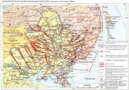
August 18 - September 1, 1945 Soviet troops carried out the Kuril landing operation and occupied, among other things, the southern Kuril Islands - Urup, Iturup, Kunashir and the Lesser Kuril ridge.
In accordance with the Decree of the Presidium of the USSR Armed Forces of February 2, 1946, in these territories, after their exclusion from Japan by Memorandum No. In 1947, it became part of the newly formed Sakhalin Oblast as part of the RSFSR.
On September 8, 1951, Japan signed the San Francisco Peace Treaty under which Japan renounced "all rights, titles and claims to the Kuril Islands and to that part of Sakhalin Island and the islands adjacent to it, sovereignty over which Japan acquired under the Portsmouth Treaty of September 5, 1905 ." When discussing the San Francisco Treaty in the US Senate, a resolution was adopted containing the following clause: It is provided that the terms of the Treaty will not mean recognition for the USSR of any rights or claims in the territories belonging to Japan on no damage to the rights and legal grounds of Japan in these territories, nor will any provisions in favor of the USSR in relation to Japan, contained in the Yalta agreement, be recognized. In view of the serious claims to the draft treaty, the representatives of the USSR, Poland and Czechoslovakia refused to sign it. The treaty was also not signed by Burma, the DRV, India, the DPRK, the PRC, and the MPR, which were not represented at the conference.
Japan makes territorial claims to the southern Kuril Islands Iturup, Kunashir, Shikotan and Khabomai with total area 5175 km². These islands are called the "Northern Territories" in Japan. Japan substantiates its claims with the following arguments:
- According to Article 2 of the Shimoda Treaty of 1855, these islands were included in Japan and they are the original possession of Japan.
- This group of islands, according to the official position of Japan, is not included in the Kuril chain (Chishima Islands) and, having signed the act of surrender and the San Francisco Treaty, Japan did not renounce them.
The USSR did not sign the San Francisco Treaty.
In 1956, the Moscow Declaration was signed, which ended the state of war and established diplomatic and consular relations between the USSR and Japan.
The peace treaty has not yet been signed in connection with the remaining claims of Japan to the islands of Kunashir and Iturup.
On November 14, 2004, Russian Foreign Minister Sergei Lavrov, on the eve of the visit of Russian President Vladimir Putin to Japan, stated that Russia, as the successor state of the USSR, recognizes the 1956 Declaration as existing and is ready to conduct territorial negotiations with Japan on its basis.
It is noteworthy that on November 1, 2010, Russian President Dmitry Medvedev became the first Russian leader to visit the Kuril Islands. President Dmitry Medvedev then stressed that “all the islands of the Kuril chain are the territory of the Russian Federation. This is our land, and we must equip the Kuriles.” The Japanese side remained implacable and called this visit regrettable, which in turn caused a response from the Russian Foreign Ministry, according to which there could be no changes in the status of the Kuril Islands.
Demography
The Kuril Islands are extremely unevenly populated. The population lives permanently only in Paramushir, Iturup, Kunashir and Shikotan. There is no permanent population on the other islands. At the beginning of 2010 there were 19 settlements: two cities (Severo-Kurilsk, Kurilsk), an urban-type settlement (Yuzhno-Kurilsk) and 16 villages.
The maximum value of the population was noted in 1989 and amounted to 29.5 thousand people. In Soviet times, the population of the islands was significantly higher due to high subsidies and a large number military personnel. Thanks to the military, the islands of Shumshu, Onekotan, Simushir and others were populated.
As of 2010, the population of the islands is 18.7 thousand people, including in the Kuril urban district - 6.1 thousand people (on the only inhabited island of Iturup, also includes Urup, Simushir, etc.); in the South Kuril urban district - 10.3 thousand people. (Kunashir, Shikotan and other islands of the Lesser Kuril Ridge (Khabomai)); in the North Kuril urban district - 2.4 thousand people (on the only inhabited island of Paramushir, also includes Shumshu, Onekotan, etc.)
History of the Kuril Islands
Background
Briefly, the history of the "belonging" of the Kuril Islands and Sakhalin Island is as follows.
1.In period 1639-1649. Russian Cossack detachments led by Moskovitinov, Kolobov, Popov explored and began to explore Sakhalin and the Kuril Islands. At the same time, Russian pioneers repeatedly swim to the island of Hokkaido, where they are peacefully met by local natives of the Ainu people. The Japanese appeared on this island a century later, after which they exterminated and partially assimilated the Ainu.
2.B 1701 Cossack constable Vladimir Atlasov reported to Peter I about the "subordination" of Sakhalin and the Kuril Islands to the Russian crown, leading to the "wonderful Nipon kingdom."
3.B 1786. by order of Catherine II, a register of Russian possessions was made on pacific ocean bringing the register to the attention of all European states as a declaration of Russia's rights to these possessions, including Sakhalin and the Kuriles.
4.B 1792. By decree of Catherine II, the entire ridge of the Kuril Islands (both Northern and Southern), as well as Sakhalin Island officially incorporated into the Russian Empire.
5. As a result of the defeat of Russia in the Crimean War 1854-1855 gg. under pressure England and France Russia forced was concluded with Japan on February 7, 1855. Treaty of Shimoda, through which four southern islands of the Kuril chain were transferred to Japan: Habomai, Shikotan, Kunashir and Iturup. Sakhalin remained undivided between Russia and Japan. At the same time, however, the right of Russian ships to enter Japanese ports was recognized, and "permanent peace and sincere friendship between Japan and Russia" was proclaimed.
6.May 7, 1875 under the Petersburg Treaty, the tsarist government as a very strange act " good will» makes incomprehensible further territorial concessions to Japan and transfers to it 18 more small islands of the archipelago. In return, Japan finally recognized Russia's right to the whole of Sakhalin. It is for this agreement referred most of all by the Japanese today, slyly silent that the first article of this treaty reads: "... and henceforth eternal peace and friendship will be established between Russia and Japan" ( the Japanese themselves violated this treaty in the 20th century repeatedly). Many Russian statesmen of those years sharply condemned this “exchange” treaty as short-sighted and harmful to the future of Russia, comparing it with the same short-sightedness as the sale of Alaska to the United States of America in 1867 for next to nothing (7 billion 200 million dollars). ), saying "now we're biting our own elbows".
7. After the Russo-Japanese War 1904-1905 gg. followed another stage of humiliation of Russia. By Portsmouth peace treaty concluded on September 5, 1905, Japan received the southern part of Sakhalin, all the Kuril Islands, and also took away from Russia the right to lease on naval bases Port Arthur and Far. When Russian diplomats reminded the Japanese that all these provisions are contrary to the 1875 treaty g., those arrogantly and arrogantly answered : « War cancels all treaties. You have failed and let's proceed from the current situation ". Reader, remember this boastful declaration of the invader!
8. Next comes the time of punishment of the aggressor for his eternal greed and territorial expansion. Signed by Stalin and Roosevelt at the Yalta Conference February 10, 1945 G. " Agreement on the Far East"It was envisaged:" ... 2-3 months after the surrender of Germany, the Soviet Union will enter the war against Japan subject to the return to the Soviet Union of the southern part of Sakhalin, all the Kuril Islands, as well as the restoration of the lease of Port Arthur and Dalny(these built and equipped hands of Russian workers, soldiers and sailors in the late XIX-early XX centuries. geographically very convenient naval bases were donated to "fraternal" China. But these bases were so necessary for our fleet in the 60-80s of revelry " cold war"and intense combat service of the fleet in remote areas of the Pacific and Indian Oceans. I had to equip the forward base Cam Ranh in Vietnam for the fleet from scratch).
9.B July 1945 g. in accordance with Potsdam Declaration heads of the victorious countries the following verdict was passed regarding the future of Japan: "The sovereignty of Japan shall be limited to four islands: Hokkaido, Kyushu, Shikoku, Honshu, and such as WE SPECIFY". August 14, 1945 the Japanese government has publicly confirmed the acceptance of the terms of the Potsdam Declaration, and on September 2 Japan unconditionally surrendered. Article 6 of the Instrument of Surrender reads: "... the Japanese government and its successors will faithfully fulfill the terms of the Potsdam Declaration to give such orders and take such actions as the Commander-in-Chief of the Allied Powers shall require in order to carry out this declaration...”. January 29, 1946 Commander-in-Chief General MacArthur DEMANDED by Directive No. 677: "The Kuril Islands, including Habomai and Shikotan, are excluded from the jurisdiction of Japan." And only after that of legal action, a Decree of the Presidium of the Supreme Soviet of the USSR of February 2, 1946 was issued, which stated: "All lands, bowels and waters of Sakhalin and the Kul Islands are the property of the Union of Soviet Socialist Republics". Thus, the Kuril Islands (both Northern and Southern), as well as about. Sakhalin, legally and were returned to Russia in accordance with international law . This could put an end to the "problem" of the Southern Kuriles and stop all further verbiage. But the story of the Kuriles continues.
10. After the end of World War II US occupied Japan and turned it into their military foothold in the Far East. In September 1951 USA, UK and a number of other states (total 49) signed San Francisco Peace Treaty with Japan, prepared in violation of the Potsdam agreements without the participation of the Soviet Union . Therefore, our government did not join the treaty. However, Art. 2, chapter II of this treaty, it is fixed in black and white: “ Japan renounces all legal grounds and claims ... to the Kuril Islands and that part of Sakhalin and the islands adjacent to it over which Japan acquired sovereignty under the Treaty of Portsmouth of September 5, 1905. However, even after this, the story with the Kuriles does not end.
October 11.19 1956 d. the government of the Soviet Union, following the principles of friendship with neighboring states, signed with the Japanese government joint declaration, according to which the state of war between the USSR and Japan ended and peace, good neighborliness and friendly relations were restored between them. When signing the Declaration as a gesture of good will and no more promised to give Japan the two southernmost islands of Shikotan and Habomai, but only after the conclusion of a peace treaty between the countries.
12. However The United States after 1956 imposed a number of military agreements on Japan, replaced in 1960 by a single "Treaty of Mutual Cooperation and Security", according to which US troops remained on its territory, and thereby the Japanese islands turned into a base of aggression against the Soviet Union. In connection with this situation, the Soviet government announced to Japan that it was impossible to transfer the promised two islands to it.. And in the same statement it was emphasized that according to the declaration of October 19, 1956, "peace, good neighborliness and friendly relations" between the countries were established. Therefore, an additional peace treaty may not be required.
Thus, the problem of the Southern Kuriles does not exist. It's been decided a long time ago. And de jure and de facto the islands belong to Russia
. In this regard, it might be to remind the Japanese of their arrogant statement in 1905 g., and also indicate that Japan was defeated in World War II and therefore has no rights to any territory, even to her ancestral lands, except for those granted to her by the victors.
And our foreign ministry
just as harshly, or in a milder diplomatic form it would be necessary to declare this to the Japanese and put an end to this, FOREVER stopping all negotiations and even conversations on this non-existent and humiliating problem of the dignity and authority of Russia.
And again the "territorial question"
However, starting from 1991
, repeatedly held meetings of the President Yeltsin and members of the Russian government, diplomats with government circles in Japan, during which the Japanese side every time importunately raises the question of the "Northern Japanese Territories".
Thus, in the Tokyo Declaration 1993
signed by the President of Russia and the Prime Minister of Japan, was again acknowledged the "existence of the territorial issue", and both sides promised to "make efforts" to resolve it. The question arises - could it be that our diplomats could not have been unaware that such declarations should not be signed, because the recognition of the existence of a “territorial issue” is contrary to the national interests of Russia (Article 275 of the Criminal Code of the Russian Federation “Treason”) ??
As for the peace treaty with Japan, it is de facto and de jure in accordance with the Soviet-Japanese Declaration of October 19, 1956. not really needed. The Japanese do not want to conclude an additional official peace treaty, and there is no need. He Japan needs more, as the side that was defeated in the Second World War, rather than Russia.
BUT citizens of Russia should know the “problem” of the South Kuriles, sucked from the finger , her exaggeration, periodic media hype around her and the litigation of the Japanese - there is consequence illegal Japan's claims in violation of the obligations it has assumed, to strictly comply with the international obligations recognized and signed by it. And such a constant desire of Japan to reconsider the ownership of many territories in the Asia-Pacific region pervades Japanese politics throughout the 20th century.
Why the Japanese, one might say, have seized the South Kuriles with their teeth and are trying to seize them again illegally? But because the economic and military-strategic importance of this region is extremely great for Japan, and even more so for Russia. This is an area of colossal seafood riches(fish, living creatures, marine animals, vegetation, etc.), deposits of minerals, and rare earth minerals, energy sources, mineral raw materials.
For example, January 29 of this year. short information slipped through the Vesti (RTR) program: a a large deposit of the rare earth metal Rhenium(75th element in the periodic table, and the only one in the world
).
Scientists allegedly calculated that it would be enough to invest only 35 thousand dollars, but the profit from the extraction of this metal will allow to bring the whole of Russia out of the crisis in 3-4 years. Apparently, the Japanese know about this and that is why they are so persistently attacking the Russian government with a demand to give them the islands.
It must be said that for 50 years of ownership of the islands, the Japanese have not built or created anything capital on them, except for light temporary buildings. Our border guards had to rebuild barracks and other buildings at the outposts. The entire economic "development" of the islands, which the Japanese are shouting to the whole world today, consisted in the predatory robbery of the riches of the islands . During the Japanese "development" from the islands rookeries of fur seals, habitats of sea otters disappeared . Part of the population of these animals our Kuril residents have already restored .
Today economic situation this whole island zone, like the whole of Russia, is heavy. Of course, significant measures are needed to support this region and take care of the Kuril people. According to the calculations of a group of deputies of the State Duma, it is possible to extract on the islands, as reported in the program "Parliamentary Hour" (RTR) on January 31 of this year, only fish products up to 2000 tons per year, with a net profit of about 3 billion dollars.
In military terms, the ridge of the Northern and Southern Kuriles with Sakhalin constitutes a complete closed infrastructure of the strategic defense of the Far East and the Pacific Fleet. They enclose the Sea of Okhotsk and turn it into an inland one. This is the area deployment and combat positions of our strategic submarines.
Without the South Kuriles, we will get a "hole" in this defense. Control over the Kuriles ensures free access of the fleet to the ocean - after all, until 1945, our Pacific Fleet, starting from 1905, was practically locked in its bases in Primorye. The means of detection on the islands provide long-range detection of air and surface enemy, the organization of anti-submarine defense of the approaches to the passages between the islands.
In conclusion, one should note such a feature in the relationship of the Russia-Japan-US triangle. It is the United States that confirms the "legitimacy" of the ownership of the islands of Japan in spite of all international treaties they have signed
.
If so, then our Foreign Ministry has every right, in response to the claims of the Japanese, to offer them to demand the return of Japan of its "southern territories" - the Caroline, Marshall and Mariana Islands.
These archipelagos former colonies of Germany, captured by Japan in 1914. Japan's dominion over these islands was sanctioned by the 1919 Treaty of Versailles. After the defeat of Japan, all these archipelagos came under US control.. So Why shouldn't Japan demand that the United States return the islands to her? Or lack of spirit?
As you can see, there is explicit double standard in Japanese foreign policy.
And one more fact that clarifies the general picture of the return of our Far Eastern territories in September 1945 and the military significance of this region. The Kuril operation of the 2nd Far Eastern Front and the Pacific Fleet (August 18 - September 1, 1945) provided for the liberation of all the Kuril Islands and the capture of the island of Hokkaido.
The accession of this island to Russia would be of great operational and strategic importance, since it would ensure the complete isolation of the "fencing" of the Sea of Okhotsk by our island territories: the Kuriles - Hokkaido - Sakhalin. But Stalin canceled this part of the operation, saying that with the liberation of the Kuriles and Sakhalin, we had resolved all our territorial issues in the Far East. BUT we don't need foreign land . In addition, the capture of Hokkaido will cost us a lot of blood, unnecessary losses of sailors and paratroopers in the most last days war.
Stalin here showed himself to be a real statesman, taking care of the country, its soldiers, and not an invader, who coveted foreign territories that were very accessible in that situation for the capture.
Source
Who owns the Kuril Islands?

Hello dear friends! Andrey Puchkov is on the line.
Today I decided to highlight a new interesting cross-cutting topic: who owns the Kuril Islands. This topic will help you understand some aspects of the history of Russia, and the most advanced boys and girls will help you choose arguments in social science when doing the USE test. Also the theme will allow .
So, who owns the Kuril Islands? Russia or Japan? And why hasn't a peace treaty been signed between Japan and Russia yet?
A brief historical digression is needed here, which, by the way, will help you broaden your horizons a little. Japan since the 17th century has been an isolated state ruled by warlike samurai. And this eastern country occupied only 4 big islands: Hokkaido, Honshu, Shikoku and Kyushu. Plus, she owned the Okinawan Islands and several hundred islands in the Pacific Ocean. Sakhalin and the islands of the Kuril ridge (Iturup, Habomai, Kunashir and Shikotan) were not officially divided between Russia and Japan, which is reflected in the Shimoda Treaty, concluded between the countries in 1855. Meanwhile, these islands were actively colonized by Russians.
If Japan had not been isolated, then, perhaps, today's Russia was limited in the East only to Siberia. However, it happened the way it did.
Here's what happened next. On September 5, 1905, following the results of the Russo-Japanese War, the Treaty of Portsmouth was concluded with Japan. The Japanese people, on which the war was a heavy burden, like the Russians, thought that Chponiya would chop off Kaschatka and Siberia from Russia.
However, Japan received only the Liaodong Peninsula with Port Arthur, half of Sakhalin Island and just those same islands of the Kuril ridge.
Plus, Russia was deprived of the South Caucasus Railway, which she herself built. The second part of Sakhalin (north of the 50th parallel) remained with Russia. Thus, the disputed territories went to Japan, and it is to this precedent that Japan is appealing today.
The next stage in the question of who owns the Kuril Islands today concerns the Second World War. You should know about military clashes on the lake. Khasan and the Khalkin Gol River.
But this was only a test of strength on the part of Japan. She was the aggressor, and the Soviet soldiers fought for their native land, not giving the enemy even her span in the literal sense of the word.
Throughout the war with Hitler, Japan did not attack, since a truce was concluded between the USSR and Japan. By the way, about the war itself, I have a cool one. However, throughout the war with Nazi Germany, the Soviet Union kept several divisions ready in the Far East.
And so, according to the conference of the Great Powers in Yalta in February 1945, the USSR undertook to enter the war with Japan no later than 3 months after the defeat of Hitler.
As a result, in August 1945, the Manchurian operation began. With it, you yourself can figure it out on the map. Let me just say that in two weeks the Soviet army completely defeated the millionth Kwantung Army of Japan, and about 100 people died from the USSR! Learned to fight!
It was during these military operations that the USSR occupied the territories that belonged to Japan under the Treaty of Portsmouth: Sakhalin Island, the Kuril Islands.
But the USSR never concluded a peace treaty with Japan. He was not present at the San Francisco Conference, at which all countries that wanted to conclude such agreements with Japan concluded them. There was also the Moscow Conference of 1956, according to which diplomatic relations were established between the countries, and the USSR announced that it would meet Japan halfway about the islands, but only after the conclusion of a peace treaty. And he is not.
Thus, the USSR took advantage of the unspoken international rule: "What is taken from the battle is holy." There were no documents. And then the USSR collapsed. By the way, there is a separate post. And Russia recognized itself as the rightful successor of the USSR.
As a result, we got not only disputed territories with Japan, but also the problem of resolving this dispute. Formally, the Japanese are right, their right to own the islands was not legally contested by the Soviet Union, but the USSR was also right, since economic and, most importantly, human resources were used to pacify the Japanese militarists, the costs of which no one paid off.
I foresee that now those who believe that the Japanese have nowhere to live and they need territories will rebel. In fact, the question, even if we theoretically raise the question of giving the Japanese disputed territories, then he will create a precedent to which everyone who is not lazy will appeal. As a result, Russia will narrow down to Moscow and the Moscow region.
And the Japanese can be offered a civilized choice: let them move to Russia, we are a multinational country - we will also accept them. Let them form the Republic of Japan, learn the Russian language, learn Russian culture, along with their own. P mouth master us Siberia and the Far East.
Only they will not agree - the descendants of the samurai. And to the question: whose Kuriles there is only one answer - they are Russian, Russian! If you have your own authoritative opinion on this issue: write about it in the comments! And also subscribe to the news of the site!
Sincerely, Andrey (Dreammanhist) Puchkov
The mysterious Kuriles are a paradise for any romantic traveler. Inaccessibility, uninhabited, geographical isolation, active volcanoes, far from a "beach climate", avaricious information - not only do not scare away, but also increase the desire to get to the foggy, fire-breathing islands - the former military fortresses of the Japanese army, still hiding deep underground many secrets.
The Kuril arc with a narrow chain of islands, like an openwork bridge, connects two worlds - Kamchatka and Japan. The Kuriles are part of the Pacific volcanic ring. The islands are the tops of the highest structures of the volcanic ridge, protruding from the water only 1-2 km, and extending into the depths of the ocean for many kilometers.

In total, there are over 150 volcanoes on the islands, of which 39 are active. The highest of them is the Alaid volcano - 2339 m, located on the island of Atlasov. The presence of numerous thermal springs on the islands is associated with volcanic activity, some of them are curative.
Experts compare the Kuril Islands with a huge botanical garden, where representatives of various floras coexist: Japanese-Korean, Manchurian and Okhotsk-Kamchatka. Here they grow together - polar birch and thousand-year-old yew, larch with spruce and wild grapes, elfin cedar and velvet tree, interweaving of woody vines and carpet thickets of lingonberries. Traveling around the islands, you can visit various natural areas, get from the pristine taiga to subtropical thickets, from the moss tundra to the jungle of giant grasses.
The seabed around the islands is covered with dense vegetation, in the thickets of which numerous fish, mollusks, marine animals find refuge, and crystal clear water allows lovers of underwater travel to navigate well in the seaweed jungle, where unique finds also occur - sunken ships and Japanese military equipment- reminders of military events in the history of the Kuril archipelago.
Yuzhno-Kurilsk, Kunashir 
GEOGRAPHY, WHERE THEY ARE, HOW TO GET TO
The Kuril Islands are a chain of islands between the Kamchatka Peninsula and the island of Hokkaido, separating the Sea of Okhotsk from the Pacific Ocean in a slightly convex arc.
The length is about 1200 km. The total area is 10.5 thousand km². To the south of them is the state border of the Russian Federation with Japan.
The islands form two parallel ridges: the Greater Kuril and the Lesser Kuril. Includes 56 islands. They are of great military-strategic and economic importance. The Kuril Islands are part of the Sakhalin region of Russia. The southern islands of the archipelago - Iturup, Kunashir, Shikotan and the Habomai group - are disputed by Japan, which includes them in the Hokkaido prefecture.
The Kuril Islands belong to the regions of the Far North
The climate on the islands is marine, rather severe, with cold and long winters, cool summers, and high humidity. The mainland monsoon climate undergoes significant changes here. In the southern part of the Kuril Islands, frosts in winter can reach -25 ° C, the average temperature in February is -8 ° C. In the northern part, the winter is milder, with frosts down to -16 ° C and -7 ° C in February.
In winter, the islands are affected by the Aleutian baric minimum, the effect of which weakens by June.
The average temperature in August in the southern part of the Kuril Islands is +17 °C, in the north - +10 °C.
Iturup Island, White Rocks Kuril Islands 
List of KURIL ISLANDS
List of islands with an area of more than 1 km² in the direction from north to south.
Name, Area, km², height, Latitude, Longitude
Great Kuril Ridge
northern group
Atlasova 150 2339 50°52" 155°34"
Shumshu 388 189 50°45" 156°21"
Paramushir 2053 1816 50°23" 155°41"
Antsiferova 7 747 50°12" 154°59"
Macanrushi 49 1169 49°46" 154°26"
Onecotan 425 1324 49°27" 154°46"
Harimkotan 68 1157 49°07" 154°32"
Chirinkotan 6 724 48°59" 153°29"
Ekarma 30 1170 48°57" 153°57"
Shiashkotan 122 934 48°49" 154°06"
middle group
Raikoke 4.6 551 48°17" 153°15"
Matua 52 1446 48°05" 153°13"
Russhua 67 948 47°45" 153°01"
Ushishir Islands 5 388 — —
Ryponkicha 1.3 121 47°32" 152°50"
Yankich 3.7 388 47°31" 152°49"
Ketoi 73 1166 47°20" 152°31"
Simushir 353 1539 46°58" 152°00"
Broughton 7 800 46°43" 150°44"
Black Brothers Islands 37,749 — —
Chirpoy 21 691 46°30" 150°55"
Brat-Chirpoev 16,749 46°28" 150°50" Kuril Islands 
Southern group
Urup 1450 1426 45°54" 149°59"
Iturup 3318.8 1634 45°00" 147°53"
Kunashir 1495.24 1819 44°05" 145°59"
Small Kuril Ridge
Shikotan 264.13 412 43°48" 146°45"
Polonsky 11.57 16 43°38" 146°19"
Green 58.72 24 43°30" 146°08"
Tanfilyev 12.92 15 43°26" 145°55"
Yuri 10.32 44 43°25" 146°04"
Anuchina 2.35 33 43°22" 146°00"
volcano Atsonapuri Kuril Islands 
Geological structure
The Kuril Islands are a typical ensimatic island arc at the edge of the Okhotsk plate. It sits above a subduction zone where the Pacific Plate is being swallowed up. Most of the islands are mountainous. The highest height is 2339 m - Atlasov Island, Alaid volcano. The Kuril Islands are located in the Pacific volcanic ring of fire in a zone of high seismic activity: out of 68 volcanoes, 36 are active, there are hot mineral springs. Large tsunamis are not uncommon. The most famous are the tsunami of November 5, 1952 in Paramushir and the Shikotan tsunami of October 5, 1994. The last major tsunami occurred on November 15, 2006 in Simushir.
South Kuril Bay, Kunashir Island 
earthquakes
In Japan, an average of 1,500 earthquakes per year is recorded, i.e. 4 earthquakes per day. Most of them are associated with movement in the earth's crust (tectonics). Over 15 centuries, 223 destructive earthquakes and 2000 of medium strength were noted and described: These, however, are far from complete numbers, since earthquakes began to be recorded in Japan with special instruments only since 1888. A significant proportion of earthquakes occur in the Kuril Islands region, where they are often appear as seaquakes. Captain Snow, who hunted sea animals here for many years, at the end of the last century, repeatedly observed such phenomena. So, for example, on July 12, 1884, 4 miles west of the Srednov stones, the gusty noise and shuddering of the ship lasted about two hours with intervals of 15 minutes and a duration of 30 seconds. The waves of the sea were not noticed at that time. The water temperature was normal, about 2.25°C.
Between 1737 and 1888 16 devastating earthquakes were noted in the region of the islands, for 1915-1916. - 3 catastrophic earthquakes in the middle part of the ridge, in 1929 - 2 similar earthquakes in the north.
Sometimes these phenomena are associated with underwater lava eruptions. The destructive impacts of earthquakes sometimes raise a huge wave (tsunami) on the sea, which is repeated several times. With colossal force, it falls on the shores, complementing the destruction from the shaking of the soil. The height of the wave can be judged, for example, from the case of the vessel “Natalia”, sent by Lebedev-Lastochkin and Shelekhov under the command of the navigator Petushkov to the 18th island: “On January 8, 1780, there was a severe earthquake; the sea rose so high that the gukor (A. S.’s ship), which was in the harbor, was carried to the middle of the island ... ”(Berkh, 1823, pp. 140-141; Pozdneev, p. 11). The wave caused by the earthquake of 1737 reached a height of 50 m and hit the shore with terrible force, breaking the rocks. Several new rocks and cliffs have risen in the Second Channel. During an earthquake on Simushir in 1849, all sources of groundwater dried up, and its population was forced to move to other places.
Paramushir island, Ebeko volcano 
Mendeleev volcano, Kunashir island 
Mineral springs
The presence of numerous hot and highly mineralized springs on the islands is associated with volcanic activity. They are found on almost all islands, especially on Kunashir, Iturup, Ushishir, Raikok, Shikotan, Ekarma. On the first of them there are quite a few boiling springs. On others, hot keys have a temperature of 35-70 ° C. They go out to different places and have different debits.
On about. A Raikoke spring with a temperature of 44°C gushes at the foot of high cliffs and forms bath-like pools in the cracks of the hardened lava.
On about. Ushishir, a powerful boiling spring, comes out in the crater of a volcano, etc. The water of many springs is colorless, transparent, and most often contains sulfur, sometimes deposited along the edges with yellow grains. For drinking purposes, the water of most sources is unsuitable.
Some springs are considered healing and on the inhabited islands are used for healing. The gases emitted by volcanoes along fissures are often also rich in sulfurous fumes.
Devil's finger Kuril Islands 
Natural resources
On the islands and in the coastal zone, industrial reserves of non-ferrous metal ores, mercury, natural gas, and oil have been explored. On the island of Iturup, in the area of the Kudryavy volcano, there is the richest mineral deposit of rhenium known in the world. Here, at the beginning of the 20th century, the Japanese mined native sulfur. The total resources of gold on the Kuril Islands are estimated at 1867 tons, silver - 9284 tons, titanium - 39.7 million tons, iron - 273 million tons. Currently, the development of minerals is not numerous.
Of all the Kuril Straits, only the Frieze Strait and the Ekaterina Strait are non-freezing navigable.
Bird's waterfall, Kunashir 
Flora and fauna
Flora
Due to the large length of the islands from north to south, the flora of the Kurils is extremely different. On the northern islands(Paramushir, Shumshu and others), due to the harsh climate, woody vegetation is rather scarce and is represented mainly by shrub forms (dwarf trees): alder (alder), birch, willow, mountain ash, cedar elfin (cedar). On the southern islands (Iturup, Kunashir) coniferous forests grow from Sakhalin fir, Ayan spruce and Kuril larch with a large participation of broad-leaved species: curly oak, maples, elms, seven-blade calopanax with a large number of woody vines: petiolate hydrangea, actinidia, Chinese magnolia vine, wild grapes, poisonous oriental toxicodendron, etc. In the south of Kunashir, there is the only wild-growing species of magnolia in Russia - obovate magnolia. One of the main landscape plants of the Kuriles, starting from the middle islands (Ketoi and south) is the Kuril bamboo, which forms impenetrable thickets on the slopes of mountains and forest edges. Tall grasses are common on all islands due to the humid climate. Various berries are widely represented: crowberry, lingonberry, blueberry, honeysuckle and others.
There are more than 40 species of endemic plants. For example, Kavakam astragalus, island wormwood, Kuril edelweiss, found on Iturup Island; Ito and Saussurea Kuril, growing on the island of Urup.
The following plants are protected on the island of Iturup: endangered Asiatic half-flower, flowering plants mainland aralia, heart-shaped aralia, seven-lobed calopanax, Japanese kandyk, Wright's viburnum, Glen's cardiocrinum, obovate peony, Fori rhododendron, Sugeroki holly, Gray's two-leaf, pearl marsh, wolfwort low, mountain peony, lichens glossodium japanese and stereocaulon naked, gymnosperms juniper Sargent and yew spiky, bryophyte bryoxiphium savatier and atractylocarpus alpine, growing near the volcano Baransky. On the island of Urup protected viburnum Wright, Aralia heart-shaped and plagiotium obtuse.
Alaid volcano, Atlasov Island 
Fauna
A brown bear lives on Kunashir, Iturup and Paramushir, the bear was also found on Shumshu, but during a long stay on the island military base, due to its relatively small size, the bears on Shumshu were mostly knocked out. Shumshu is a connecting island between Paramushir and Kamchatka, and individual bears are now found there. Foxes and small rodents live on the islands. A large number of birds: plovers, gulls, ducks, cormorants, petrels, albatrosses, passerines, owls, falconiformes and others. Lots of bird colonies.
coastal undersea world, unlike the islands, is not only numerous, but also very diverse. Seals, sea otters, killer whales, sea lions live in coastal waters. Of great commercial importance are: fish, crabs, molluscs, squids, crustaceans, trepangs, sea cucumbers, sea urchins, seaweed, whales. The seas washing the shores of Sakhalin and the Kuriles are among the most productive areas of the World Ocean.
Endemic animals (mollusks) are also present on Iturup Island: Iturup lacustrine, Iturup sharovka (Lake Reidovo), Kuril pearl mussel, Sinanodont-like kunashiriya and Iturup zatvorka are found on Dobroye Lake.
On February 10, 1984, the State nature reserve"Kuril". 84 species included in the Red Book of Russia live on its territory.
Kunashir Island, Pervukhin Bay 
History of the islands
17th-18th century
The honor of discovery, exploration and initial development of the Kuril Islands belongs to Russian expeditions and colonists.
The first visit to the islands is attributed to the Dutchman Gerrits Fries, who visited Fr. Uruppu. Calling this land "Company Land" - Companys lant (Reclus, 1885, p. 565), Friese, however, did not assume that it was part of the Kuril ridge.
The remaining islands north of Uruppu to Kamchatka were discovered and described by Russian "explorers" and navigators. And the Russians discovered Uruppa for the second time at the beginning of the 18th century. Japan at that time were known only o. Kunashiri and the Malaya Kuril ridge, but they were not part of the Japanese Empire. The northernmost colony of Japan was about. Hokkaido.
The server islands of the Kuril ridge were first reported by the clerk of the Anadyr prison, the Pentecostal Vl. Atlasov, who discovered Kamchatka. In 1697, he walked along the western coast of Kamchatka to the south to the mouth of the river. Golygina and from here "I saw how there are islands at sea."
Not knowing that trade with foreigners had been prohibited in Japan since 1639, Peter I in 1702 gave the task of establishing good-neighbourly trade relations with Japan. From that time on, Russian expeditions persistently made their way south from Kamchatka in search of a trade route to Japan. In 1706, the Cossack M. Nasedkin clearly saw land in the south from Cape Lopatka. According to the order of the Yakut voivode to “provide” this land, the Cossack ataman D. Antsiferov and Yesaul Ivan Kozyrevsky in 1711 went to about. Shumushu (Shumshu) and Paramusir (Paramushir), and upon their return they made a “drawing” of all the islands. To draw the southern islands, they used the stories of Japanese fishermen who were thrown out by a storm to Kamchatka and saw the southern islands.
In the campaign of 1713, Yesaul Ivan Kozyrevsky again "visited" the islands beyond the "transitions" (straits) and made a new "drawing". The surveyors Evreinov and Luzhin were surveying on the map in 1720 from Kamchatka to the Sixth Island (Simushiru). After 10 years, the brave leader of the "explorers" V. Shestakov with 25 service people visited the five northern islands. Following him, thorough work "for the sake of observation and finding a way to Japan" was carried out by Captain Spanberg, Bering's assistant on his second expedition.
During 1738-1739. Spanberg mapped and described almost all the islands. Based on his materials, 40 islands under Russian names were shown on the “General Map of the Russian Empire” in the Academic Atlas of 1745, for example, the islands of Anfinogen, Krasnogorsk, Stolbovoy, Krivoy, Osypnoy, Goat, Brother, Sister, Alder, Zeleny, etc. As a result of Spanberg's work, the composition of the entire island ridge was first clarified and mapped. The previously known extreme southern islands (“Company Land”, the island of “States”) were defined as components of the Kuril ridge.
For a long time before that, there was an idea of some large "Land of Gama" to the east of Asia. The legend of Gama's hypothetical Land was forever dispelled.
In the same years, the Russians got acquainted with the small indigenous population of the islands - the Ainu. According to the largest Russian geographer of that time, S. Krasheninnikov, on about. Shumushu by the 40s of the 18th century. there were only 44 souls.
In 1750 he sailed to about. Shimushiru is the foreman of the First Nick Island. Storozhev. After 16 years (in 1766), foremen Nikita Chikin, Chuprov and centurion Iv. Black again tried to find out the number of all the islands and the population on them.
After the death of Chikina on about. Simushiru I. Cherny spent the winter on this island. In 1767 he reached Fr. Etorofu, and then settled on about. Uruppu. Returning to Kamchatka in the autumn of 1769, Cherny reported that on 19 islands (including Etorofu) 83 "shaggy" (Ainu) had accepted Russian citizenship.
In their actions, Chikin and Cherny were obliged to be guided by the instructions of the Bolsheretsk office: “When traveling to distant islands and back ... describe .... their size, the width of the straits, which are on the islands, animals, also rivers, lakes and fish in them. .. To visit about gold and silver ores and pearls ... offenses, taxes, robbery ... and other acts contrary to the decrees and rudeness and fornication violence, not to show, expecting the highest mercy and reward for jealousy. After some time, the Tyumen merchant Yak. Nikonov, as well as the sailors of the Protodyakonov trading company and other "explorers" delivered more accurate news about the islands.
In order to firmly and finally consolidate the islands and develop them, the chief commander of Kamchatka, Bem, proposed to build on about. Uruppu fortification, create a Russian settlement there and develop the economy. To implement this proposal and develop trade with Japan, the Yakut merchant Lebedev-Lastochkin equipped an expedition in 1775 under the command of the Siberian nobleman Antipin. The expedition ship "Nikolai" crashed near about. Uruppu. Two years later, to Antipin on about. Uruppa was sent from Okhotsk the ship "Natalia" under the command of navigator M. Petushkov.
After wintering on Uruppu, "Natalia" went to Akkesi Bay on about. Hokkaido and met a Japanese ship here. By agreement with the Japanese, Antipin and the translator, the Irkutsk townsman Shabalin, appeared in 1779 with the goods of Lebedev-Lastochkin on about. Hokkaido to Akkeshi Bay. Strictly mindful of the instructions received by Antipin that “... having met with the Japanese, act courteously, affectionately, decently ... find out what Russian goods they need“ things and what kind of things you can get from them in return, set prices and whether they would like to for mutual bargaining, to make an agreement on some island that would guide the future ... to establish peaceful relations with the Japanese, ”the merchants counted on trade that would be beneficial for both sides. But their hopes were not justified. In Akkesi, they were given the prohibition of the Japanese not only to trade on about. Hokkaido (Matsmai), but also sail to Etorofu and Kunashiri.
Since that time, the Japanese government began to oppose the Russians in the southern islands in every possible way. In 1786, it commissioned an official, Mogami Tokunai, to inspect the islands. Finding three Russians on Etorofu and interrogating them, Tokunai handed them an order: “Foreign nationals are strictly prohibited from entering Japanese territory. Therefore, I order you to return to your state as soon as possible. The movement of Russian merchants to the south for peaceful purposes was interpreted by the Japanese in a completely different way.
city of Severo-Kurilsk 
19th century
In 1805, a representative of the Russian-American Company, Nikolai Rezanov, who arrived in Nagasaki as the first Russian envoy, tried to resume negotiations on trade with Japan. But he also failed. However, the Japanese officials, who were not satisfied with the despotic policy of the supreme power, hinted to him that it would be nice to carry out a forceful action in these lands, which could push the situation off the ground. This was carried out on behalf of Rezanov in 1806-1807 by an expedition of two ships led by Lieutenant Khvostov and midshipman Davydov. Ships were plundered, a number of trading posts were destroyed, and a Japanese village was burned on Iturup. Later they were tried, but the attack for some time led to a serious deterioration in Russian-Japanese relations. In particular, this was the reason for the arrest of Vasily Golovnin's expedition.
The first distinction between the possessions of Russia and Japan in the Kuril Islands was made in the Shimoda Treaty of 1855.
In exchange for the right to own southern Sakhalin, Russia transferred to Japan in 1875 all the Kuril Islands.
20th century
After the defeat in 1905 in the Russo-Japanese War, Russia transferred the southern part of Sakhalin to Japan.
In February 1945, the Soviet Union promised the United States and Great Britain to start a war with Japan on the condition that Sakhalin and the Kuril Islands be returned to it.
February 2, 1946. Decree of the Presidium of the Supreme Soviet of the USSR on the formation on the territory of South Sakhalin and the Kuril Islands of the South Sakhalin Region as part of the Khabarovsk Territory of the RSFSR.
November 5, 1952. A powerful tsunami hit the entire coast of the Kuriles, Paramushir suffered the most. A giant wave washed away the city of Severo-Kurilsk (formerly Kasivabara). The press was forbidden to mention this catastrophe.
In 1956, the Soviet Union and Japan adopted a Joint Treaty officially ending the war between the two states and transferring Habomai and Shikotan to Japan. Signing the agreement, however, did not work out, because it came out that Japan was waiving the rights to Iturup and Kunashir, because of which the United States threatened not to give Japan the island of Okinawa.
Church of the Holy Trinity, Yuzhno-Kurilsk 
The Problem of Ownership
At the end of World War II in February 1945, at the Yalta Conference of the Heads of Powers, the countries participating in the anti-Hitler coalition, an agreement was reached on the unconditional return of the southern part of Sakhalin and the transfer of the Kuril Islands to the Soviet Union after the victory over Japan.
On July 26, 1945, within the framework of the Potsdam Conference, the Potsdam Declaration was adopted, which limited the sovereignty of Japan to the islands of Honshu, Hokkaido, Kyushu, and Shikoku. On August 8, the USSR joined the Potsdam Declaration. On August 14, Japan accepted the terms of the Declaration and on September 2, 1945, signed the Instrument of Surrender confirming these terms. But these documents did not speak directly about the transfer of the Kuril Islands to the USSR.
On August 18 - September 1, 1945, Soviet troops carried out the Kuril landing operation and occupied, among other things, the southern Kuril Islands - Urup, Iturup, Kunashir and the Lesser Kuril ridge.
In accordance with the Decree of the Presidium of the USSR Armed Forces of February 2, 1946, in these territories, after their exclusion from Japan by Memorandum No. In 1947, it became part of the newly formed Sakhalin Oblast as part of the RSFSR.
On September 8, 1951, Japan signed the San Francisco Peace Treaty, according to which it renounced "all rights, titles and claims to the Kuril Islands and to that part of Sakhalin Island and the islands adjacent to it, sovereignty over which Japan acquired under the Portsmouth Treaty of September 5, 1905 G." When discussing the San Francisco Treaty in the US Senate, a resolution was adopted containing the following clause: It is provided that the terms of the Treaty will not mean recognition for the USSR of any rights or claims in the territories belonging to Japan on no damage to the rights and legal grounds of Japan in these territories, nor will any provisions in favor of the USSR in relation to Japan, contained in the Yalta agreement, be recognized. In view of the serious claims to the draft treaty, the representatives of the USSR, Poland and Czechoslovakia refused to sign it. The treaty was also not signed by Burma, the DRV, India, the DPRK, the PRC, and the MPR, which were not represented at the conference.
Japan makes territorial claims to the southern Kuril Islands Iturup, Kunashir, Shikotan and Khabomai with a total area of 5175 km². These islands are called the "Northern Territories" in Japan. Japan substantiates its claims with the following arguments:
According to Article 2 of the Shimoda Treaty of 1855, these islands were included in Japan and they are the original possession of Japan.
This group of islands, according to the official position of Japan, is not included in the Kuril chain (Chishima Islands) and, having signed the act of surrender and the San Francisco Treaty, Japan did not renounce them.
The USSR did not sign the San Francisco Treaty.
However, the Shimodsky treatise is considered annulled due to the Russo-Japanese War (1905).
In 1956, the Moscow Declaration was signed, which ended the state of war and established diplomatic and consular relations between the USSR and Japan. Article 9 of the Declaration states, in part:
The USSR, meeting the wishes of Japan and taking into account the interests of the Japanese state, agrees to the transfer of the Habomai Islands and the Shikotan Islands to Japan, however, that the actual transfer of these islands to Japan will be made after the conclusion of the Peace Treaty.
On November 14, 2004, Russian Foreign Minister Sergei Lavrov, on the eve of the visit of Russian President Vladimir Putin to Japan, stated that Russia, as the successor state of the USSR, recognizes the 1956 Declaration as existing and is ready to conduct territorial negotiations with Japan on its basis.
It is noteworthy that on November 1, 2010, Russian President Dmitry Medvedev became the first Russian leader to visit the Kuril Islands. President Dmitry Medvedev then stressed that “all the islands of the Kuril chain are the territory of the Russian Federation. This is our land, and we must equip the Kuriles.” The Japanese side remained implacable and called this visit regrettable, which in turn caused a response from the Russian Foreign Ministry, according to which there could be no changes in the status of the Kuril Islands.
Some Russian official experts, in search of a solution that could satisfy both Japan and Russia, offer very peculiar options. So, Academician K.E. Chervenko in April 2012, in an article on the possibility of a final settlement of the territorial dispute between the Russian Federation and Japan, voiced an approach in which the countries participating in the San Francisco Treaty (states that have the right to determine the international legal status of South Sakhalin with the adjacent islands and all the Kuril Islands) recognize the Kuriles de facto the territory of the Russian Federation, leaving behind Japan the right to consider them de jure (under the terms of the aforementioned agreement) not included in Russia.
Cape Stolbchaty, Kunashir Island 
Population
The Kuril Islands are extremely unevenly populated. The population lives permanently only in Paramushir, Iturup, Kunashir and Shikotan. There is no permanent population on the other islands. At the beginning of 2010, there are 19 settlements: two cities (Severo-Kurilsk, Kurilsk), an urban-type settlement (Yuzhno-Kurilsk) and 16 villages.
The maximum value of the population was noted in 1989 and amounted to 29.5 thousand people. In Soviet times, the population of the islands was significantly higher due to high subsidies and a large number of military personnel. Thanks to the military, the islands of Shumshu, Onekotan, Simushir and others were populated.
As of 2010, the population of the islands is 18.7 thousand people, including in the Kuril urban district - 6.1 thousand people (on the only inhabited island of Iturup, also includes Urup, Simushir, etc.); in the South Kuril urban district - 10.3 thousand people. (Kunashir, Shikotan and other islands of the Lesser Kuril Ridge (Khabomai)); in the North Kuril urban district - 2.4 thousand people (on the only inhabited island of Paramushir, also includes Shumshu, Onekotan, etc.).
Onekotan Island
Economy and development
On August 3, 2006, at a meeting of the Government of the Russian Federation, the Federal Program for the Development of the Islands from 2007 to 2015 was approved, including 4 blocks: transport infrastructure, fish processing industry, social infrastructure and energy solutions. The program provides:
The allocation of funds for this program is almost 18 billion rubles, that is, 2 billion rubles a year, which is equivalent to about 300 thousand rubles for each inhabitant of the islands, which will increase the population from 19 to 30 thousand people.
The development of the fishing industry - at present, there are only two fish factories on the islands, and both are state-owned. The Ministry of Economic Development and Trade of the Russian Federation proposes to create another 20 new fish hatcheries to replenish biological resources. The federal program provides for the creation of the same number of private fish breeding plants and the reconstruction of one fish processing plant.
On the islands, it is planned to build new kindergartens, schools, hospitals, develop a transport network, including the construction of a modern all-weather airport.
The problem of electricity shortage, which is four times more expensive in the Kuril Islands than in Sakhalin, is planned to be solved through the construction of power plants operating on geothermal sources, using the experience of Kamchatka and Japan.
In addition, in May 2011, the Russian authorities announced their intention to allocate an additional 16 billion rubles, thereby doubling the funding for the Kuril Islands development program.
In February 2011, it became known about plans to strengthen the defense of the Kuriles with an air defense brigade, as well as a mobile coastal missile system with Yakhont anti-ship missiles.
__________________________________________________________________________________________
SOURCE OF INFORMATION AND PHOTO:
Team Nomads.
Photo: Tatyana Selena, Viktor Morozov, Andrey Kapustin, Artem Demin
The Russian Academy of Sciences. Institute of Geography RAS. Pacific Institute of Geography FEB RAS; Editors: V. M. Kotlyakov (chairman), P. Ya. Baklanov, N. N. Komedchikov (chief editor) and others; Rep. editor-cartographer Fedorova E. Ya. Atlas of the Kuril Islands. — M.; Vladivostok: IPTs "DIK", 2009. - 516 p.
Department of Natural Resources and Environmental Protection of the Ministry of Natural Resources of Russia for the Sakhalin Region. Report "On the state and protection of the environment of the Sakhalin region in 2002" (2003). Retrieved June 21, 2010. Archived from the original on August 23, 2011.
Sakhalin region. Official site of the governor and government of the Sakhalin region. Retrieved June 21, 2010. Archived from the original on October 7, 2006.
Makeev B. « Kuril problem: military aspect". World Economy and International Relations, 1993, No. 1, p. 54.
Wikipedia site.
Solovyov A.I. Kuril Islands / Glavsevmorput. - Ed. 2nd. - M .: Publishing House of the Glavsevmorput, 1947. - 308 p.
Atlas of the Kuril Islands / Russian Academy of Sciences. Institute of Geography RAS. Pacific Institute of Geography FEB RAS; Editors: V. M. Kotlyakov (chairman), P. Ya. Baklanov, N. N. Komedchikov (chief editor) and others; Rep. editor-cartographer Fedorova E. Ya .. - M .; Vladivostok: IPTs "DIK", 2009. - 516 p. - 300 copies. - ISBN 978-5-89658-034-8.
http://www.kurilstour.ru/islands.shtml


