In what part of Eurasia is the Caspian lake. Interesting facts about the Caspian Sea: depth, relief, coastline, resources
Caspandmaboutre(Caspian) - the largest enclosed body of water on Earth. In size, the Caspian Sea is much larger than such lakes as the Upper, Victoria, Huron, Michigan, Baikal. According to formal features, the Caspian Sea is an endorheic lake. However, given its large size, brackish waters and sea-like regime, this body of water is called the sea.
According to one of the hypotheses, the Caspian Sea (among the ancient Slavs - the Khvalyn Sea) got its name in honor of the Caspian tribes who lived before our era on its southwestern coast.
The Caspian Sea washes the shores of five states: Russia, Azerbaijan, Iran, Turkmenistan and Kazakhstan.
The Caspian Sea is elongated in the meridional direction and is located between 36°33' and 47°07' N latitude. and 45°43΄ and 54°03΄ E (without Kara-Bogaz-Gol Bay). The length of the sea along the meridian is about 1200 km; the average width is 310 km. north coast Caspian Sea bordered by the Caspian lowland, the eastern one by the deserts of Central Asia; in the west, the mountains of the Caucasus approach the sea, in the south, near the coast, the Elburz ridge stretches.
The surface of the Caspian Sea is much lower than the level of the World Ocean. Its current level fluctuates around -27 ... -28 m. These levels correspond to the sea surface area of 390 and 380 thousand km 2 (without the Kara-Bogaz-Gol Bay), the volume of water is 74.15 and 73.75 thousand km 3, average depth is about 190 m.
The Caspian Sea is traditionally divided into three large parts: the North (24% of the sea area), the Middle (36%) and the South Caspian (40%), which differ significantly in morphology and regime, as well as the large and isolated Kara-Bogaz-Gol Bay. The northern, shelf part of the sea is shallow: its average depth is 5–6 m, maximum depths are 15–25 m, and the volume is less than 1% of the total water mass of the sea. The Middle Caspian is a separate basin with the area of maximum depths in the Derbent depression (788 m); its average depth is about 190 m. In the South Caspian, the average and maximum depths are 345 and 1025 m (in the South Caspian depression); 65% of the water mass of the sea is concentrated here.
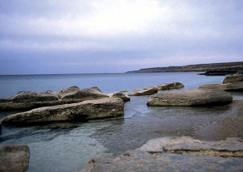
There are about 50 islands in the Caspian Sea with total area approximately 400 km 2 ; the main ones are Tyuleniy, Chechen, Zyudev, Konevsky, Dzhambaysky, Durneva, Ogurchinsky, Apsheronsky. The length of the coastline is approximately 6.8 thousand km, with islands - up to 7.5 thousand km. The shores of the Caspian Sea are diverse. In the northern and eastern parts, they are quite strongly indented. There are large bays Kizlyarsky, Komsomolets, Mangyshlaksky, Kazakhsky, Kara-Bogaz-Gol, Krasnovodsky and Turkmensky, many bays; at west coast- Kyzylagach. The largest peninsulas are Agrakhansky, Buzachi, Tyub-Karagan, Mangyshlak, Krasnovodsky, Cheleken and Apsheronsky. The most common banks are accumulative; areas with abrasion shores are found along the contour of the Middle and South Caspian.
More than 130 rivers flow into the Caspian Sea, the largest of which is the Volga. , Ural, Terek, Sulak, Samur, Kura, Sefidrud, Atrek, Emba (its runoff enters the sea only in high-water years). Nine rivers have deltas; the largest are located at the mouths of the Volga and Terek.
The main feature of the Caspian Sea, as a drainless reservoir, is instability and a wide range of long-term fluctuations in its level. This most important hydrological feature of the Caspian Sea has a significant impact on all its other hydrological characteristics, as well as on the structure and regime of river mouths, on coastal zones. In the Caspian Sea level varied in the range of ~200 m: from -140 to +50 m BS; in from -34 to -20 m BS. From the first third of the 19th century and until 1977, sea level dropped by about 3.8 m - to the lowest point in the last 400 years (-29.01 m BS). In 1978–1995 The level of the Caspian Sea rose by 2.35 m and reached -26.66 m BS. Since 1995, a certain downward trend has dominated - to -27.69 m BS in 2013.
During major periods, the northern shore of the Caspian Sea shifted to Samarskaya Luka on the Volga, and perhaps even further. At maximum transgressions, the Caspian turned into a sewage lake: excess water flowed through the Kuma-Manych depression into the Sea of Azov and further into the Black Sea. In extreme regressions, the southern coast of the Caspian Sea was shifted to the Apsheron threshold.
Long-term fluctuations in the level of the Caspian are explained by changes in the structure of the water balance of the Caspian Sea. The sea level rises when the incoming part of the water balance (primarily river runoff) increases and exceeds the outgoing part, and decreases if the inflow of river waters decreases. The total water flow of all rivers averages 300 km 3 /year; while the five largest rivers account for almost 95% (the Volga provides 83%). During the period of the lowest sea level, in 1942–1977, the river flow was 275.3 km 3 / year (of which 234.6 km 3 / year is the flow of the Volga), precipitation - 70.9, underground flow - 4 km 3 /year, and evaporation and outflow to the Kara-Bogaz-Gol Bay - 354.79 and 9.8 km 3 /year. During the period of intensive sea level rise, in 1978-1995, respectively, 315 (Volga - 274.1), 86.1, 4, 348.79 and 8.7 km 3 / year; in the modern period - 287.4 (Volga - 248.2), 75.3, 4, 378.3 and 16.3 km 3 / year.
The intra-annual changes in the level of the Caspian Sea are characterized by a maximum in June–July and a minimum in February; the range of intra-annual level fluctuations is 30–40 cm. Surge-surge level fluctuations are manifested throughout the sea, but they are most significant in the northern part, where, with maximum surges, the level can rise by 2–4.5 m and the edge “retreat” by several tens of kilometers inland, and in case of surges - to drop by 1–2.5 m. Seiche and tidal level fluctuations do not exceed 0.1–0.2 m.
Despite the relatively small size of the reservoir in the Caspian Sea, there is strong excitement. highest heights waves in the South Caspian can reach 10–11 m. Wave heights decrease in the direction from south to north. Storm waves can develop at any time of the year, but more often and more dangerously in the cold half of the year.
The Caspian Sea is generally dominated by wind currents; nevertheless, runoff currents play an appreciable role on the estuarine coasts of large rivers. Cyclonic water circulation prevails in the Middle Caspian, and anticyclonic circulation in the South Caspian. In the northern part of the sea, the patterns of wind currents are more irregular and depend on the characteristics and variability of the wind, bottom topography and coastlines, river runoff and aquatic vegetation.
The water temperature is subject to significant latitudinal and seasonal changes. In winter, it varies from 0–0.5 o C at the ice edge in the north of the sea to 10–11 o C in the south. In summer, the water temperature in the sea averages 23–28 o C, and in shallow coastal waters in the Northern Caspian it can reach 35–40 o C. At depths, a constant temperature is maintained: deeper than 100 m it is 4–7 o C.
In winter, only the northern part of the Caspian Sea freezes; in harsh winter- the entire Northern Caspian and coastal zones of the Middle Caspian. Freezing in the Northern Caspian lasts from November to March.
The salinity of water changes especially sharply in the northern part of the sea: from 0.1‰ on the estuarine coasts of the Volga and Urals to 10–12‰ on the border with the Middle Caspian. In the Northern Caspian, the temporal variability of water salinity is also great. In the middle and southern parts In the sea, salinity fluctuations are small: basically it is 12.5–13.5‰, increasing from north to south and from west to east. The highest water salinity is in the Kara-Bogaz-Gol Bay (up to 300‰). With depth, the salinity of water increases slightly (by 0.1–0.3‰). The average salinity of the sea is about 12.5‰.
More than a hundred species of fish live in the Caspian Sea and the mouths of the rivers flowing into it. There are Mediterranean and Arctic invaders. Gobies, herring, salmon, carp, mullet and sturgeon fish serve as the object of fishing. The latter number five species: sturgeon, beluga, stellate sturgeon, spike and sterlet. The sea is capable of producing up to 500-550 thousand tons of fish annually if overfishing is not allowed. Of the marine mammals, the endemic Caspian seal lives in the Caspian Sea. Every year 5-6 million waterfowl migrate through the Caspian region.
The economy of the Caspian Sea is connected with oil and gas production, shipping, fishing, extraction of seafood, various salts and minerals (Kara-Bogaz-Gol Bay), with the use of recreational resources. The explored oil resources in the Caspian Sea are about 10 billion tons, the total resources of oil and gas condensate are estimated at 18–20 billion tons. Oil and gas are being produced on an ever-increasing scale. Used by the Caspian Sea and water transport, including along the river-sea and sea-river routes. The main ports of the Caspian Sea: Astrakhan, Olya, Makhachkala (Russia), Aktau, Atyrau (Kazakhstan), Baku (Azerbaijan), Nowshahr, Bender-Enzeli, Bender-Torkemen (Iran) and Turkmenbashi (Turkmenistan).
The economic activity and hydrological features of the Caspian Sea create a number of serious environmental and water management problems. Among them: anthropogenic pollution of river and sea waters (mainly with oil products, phenols and synthetic surfactants), poaching and reduction of fish stock, especially sturgeons; damage to the population and coastal economic activity due to large-scale and rapid changes in the level of the reservoir, the impact of numerous hazardous hydrological phenomena and hydrological and morphological processes.
The total economic damage for all the Caspian countries associated with the rapid and significant recent rise in the level of the Caspian Sea, the flooding of part of the coastal land, the destruction of coasts and coastal structures, was estimated at 15 to 30 billion US dollars. It took urgent engineering measures to protect the coast.
A sharp drop in the level of the Caspian Sea in the 1930s–1970s. led to less damage, but they were significant. The navigable approach channels became shallow, the shallow seashore at the mouths of the Volga and the Urals became heavily overgrown, which became an obstacle to the passage of fish into the rivers for spawning. It was necessary to build fish passages through the seasides mentioned above.
Among the unresolved problems is the lack of an international agreement on the international legal status of the Caspian Sea, the division of its water area, bottom and subsoil.
The Caspian Sea is the object of many years of research by specialists from all the Caspian states. Such domestic organizations as the State Oceanographic Institute, the Institute of Oceanology of the Russian Academy of Sciences, the Hydrometeorological Center of Russia, the Caspian Research Institute of Fisheries, the Faculty of Geography of Moscow State University, etc. took an active part in the study of the Caspian Sea.
The Caspian Lake is one of the most unique places on the ground. It keeps many secrets connected with the history of the development of our planet.
Position on the physical map
The Caspian is an internal drainless salt lake. The geographical position of the Caspian Lake is the continent of Eurasia at the junction of parts of the world (Europe and Asia).
The length of the lakeshore line is from 6500 km to 6700 km. Taking into account the islands, the length increases to 7000 km.
The coastal areas of the Caspian Lake are mostly low-lying. Their northern part is indented by the channels of the Volga and the Urals. The river delta is rich in islands. The surface of the water in these areas is covered with thickets. Swampiness of large areas of land is noted.
The eastern coast of the Caspian adjoins to the lake. There are significant limestone deposits on the shores of the lake. The western and part of the eastern coast is characterized by a winding coastline.
The Caspian lake on the map is represented by a significant size. The entire territory adjacent to it was called the Caspian Sea.
Some characteristics
The Caspian Lake in terms of its area and the volume of water in it has no equal on Earth. It stretches from north to south for 1049 kilometers, and its longest length from west to east is 435 kilometers.

If we take into account the depth of reservoirs, their area and volume of water, then the lake is commensurate with the Yellow, Baltic and Black Seas. By the same parameters, the Caspian surpasses the Tyrrhenian, Aegean, Adriatic and other seas.
The volume of water available in the Caspian Lake is 44% of the reserve of all lake waters of the planet.
Lake or sea?
Why is the Caspian lake called the sea? Is it really the impressive size of the reservoir that caused the assignment of such a “status”? More precisely, this was one of those reasons.
Others include a huge mass of water in the lake, the presence of a large wave during storm winds. All this is typical for real seas. It becomes clear why the Caspian Lake is called the sea.
But here one of the main conditions is not named, which must necessarily exist so that geographers can classify a reservoir as a sea. We are talking about the direct connection of the lake with the oceans. Exactly this condition The Caspian does not match.
Where the Caspian Lake is located, a deepening in the earth's crust was formed several tens of thousands of years ago. Today it is filled with the waters of the Caspian Sea. According to scientists, at the end of the 20th century, the water level in the Caspian Sea was 28 meters below the level of the World Ocean. The direct connection of the waters of the lake and the ocean ceased to exist approximately 6 millennia ago. The conclusion from the above is that the Caspian Sea is a lake.
There is another feature that distinguishes the Caspian Sea from the sea - the salinity of the water in it is almost 3 times lower than the salinity of the World Ocean. The explanation for this is that about 130 large and small rivers carry fresh water to the Caspian Sea. The Volga makes the most significant contribution to this work - it is she who “gives” up to 80% of all water to the lake.
The river played another important role in the life of the Caspian Sea. It is she who will help find the answer to the question of why the Caspian Lake is called the sea. Now that many channels have been built by man, it has become a fact that the Volga connects the lake with the oceans.
The history of the lake
The modern appearance and geographical position of the Caspian Lake are due to continuous processes occurring on the surface of the Earth and in its depths. There were times when the Caspian was connected with the Sea of Azov, and through it with the Mediterranean and Black. That is, tens of thousands of years ago, the Caspian Lake was part of the World Ocean.

As a result of the processes associated with the uplift and lowering of the earth's crust, mountains appeared on the site of the modern Caucasus. They isolated a body of water that was part of a vast ancient ocean. More than one tens of thousands of years passed before the basins of the Black and Caspian Seas separated. But for a long time, the connection between their waters was carried out through the strait, which was on the site of the Kumo-Manych depression.
Periodically, the narrow strait was either drained or refilled with water. This was due to fluctuations in the level of the oceans and changes in the appearance of the land.
In a word, the origin of the Caspian Lake is closely connected with the general history of the formation of the Earth's surface.
The lake got its modern name because of the tribes of the Caspians, who inhabited the eastern parts of the Caucasus and the steppe zones of the Caspian territories. Over the entire history of its existence, the lake had 70 different names.
Territorial division of the lake-sea
The depth of the Caspian Lake in its different places is very different. Based on this, the entire water area of the lake-sea was conditionally divided into three parts: the Northern Caspian, the Middle and the Southern.

Shallow - this is the northern part of the lake. The average depth of these places is 4.4 meters. The highest indicator is a mark of 27 meters. And on 20% of the entire area of the Northern Caspian, the depth is only about a meter. It is clear that this part of the lake is of little use for navigation.
The Middle Caspian has the greatest depth of 788 meters. The deep part occupies lakes. The average depth here is 345 meters, and the greatest is 1026 meters.
Seasonal changes at sea
Due to the large length of the reservoir from north to south, the climatic conditions on the coast of the lake are not the same. Seasonal changes in the territories adjacent to the reservoir also depend on this.

In winter south coast lakes in Iran, the water temperature does not fall below 13 degrees. During the same period, in the northern part of the lake off the coast of Russia, the water temperature does not exceed 0 degrees. The Northern Caspian is covered with ice during 2-3 months of the year.
In summer, almost everywhere the Caspian Lake warms up to 25-30 degrees. warm water, excellent sandy beaches, sunny weather create excellent conditions for people to relax.
Caspian on the political map of the world
Five states are located on the shores of the Caspian Lake - Russia, Iran, Azerbaijan, Kazakhstan and Turkmenistan.
The territory of Russia includes the western regions of the Northern and Middle Caspian. Iran is located on the southern shores of the sea, it owns 15% of the entire length of the coastline. The eastern coastline is shared by Kazakhstan and Turkmenistan. Azerbaijan is located in the southwestern territories of the Caspian Sea.
The issue of dividing the water area of the lake between the Caspian states has been the most acute for many years. The heads of the five states are trying to find a solution that would satisfy the needs and requirements of everyone.
The natural wealth of the lake
Caspian from ancient times for local residents served as a waterway.

The lake is famous for its valuable species of fish, in particular sturgeon. Their reserves account for up to 80% of the world's resources. The issue of preserving the sturgeon population is of international importance, it is solved at the level of the government of the Caspian states.
The Caspian seal is another mystery of the unique sea-lake. Scientists have not yet fully unraveled the mystery of the appearance of this animal in the waters of the Caspian Sea, as well as other species of animals of northern latitudes.
In total, 1809 species of various groups of animals live in the Caspian Sea. There are 728 species of plants. Most of them are the "indigenous inhabitants" of the lake. But there is a small group of plants that were deliberately brought here by man.
Of the minerals, the main wealth of the Caspian is oil and gas. Some information sources compare the oil reserves of the Caspian Lake fields with Kuwait. Industrial marine mining of black gold has been carried out on the lake since the end of the 19th century. The first well appeared on the Apsheron shelf in 1820.
Today, governments unanimously believe that the region should not be considered only as a source of oil and gas, while leaving the Caspian ecology unattended.
In addition to oil fields, there are deposits of salt, stone, limestone, clay and sand on the territory of the Caspian Sea. Their production also could not but affect ecological situation region.
Sea level fluctuations
The water level in the Caspian Lake is not constant. This is evidenced by evidence relating to the IV century BC. The ancient Greeks who explored the sea discovered big bay at the confluence of the Volga. The existence of a shallow strait between the Caspian and the Sea of Azov was also discovered by them.
There are other data on the water level in the Caspian Lake. The facts show that the level was much lower than it is now. Ancient evidence is architectural structures found on the seabed. The buildings date back to the 7th-13th centuries. Now the depth of their flooding is from 2 to 7 meters.
In 1930, the water level in the lake began to decline catastrophically. The process went on for almost fifty years. This caused great concern among people, since all the economic activities of the Caspian region are adapted to the previously established water level.
Since 1978 the level has started to rise again. Today it has become more than 2 meters taller. This is also an undesirable phenomenon for people living on the coast of the lake-sea.
Climate change is said to be the main reason for fluctuations in the lake. This entails an increase in the volume of river water entering the Caspian, the amount of precipitation, and a decrease in the intensity of water evaporation.
However, it cannot be said that this is the only opinion that explains the fluctuations in the water level in the Caspian Lake. There are others, no less plausible.
Human activities and environmental issues
The area of the catchment basin of the Caspian Lake is 10 times larger than the surface of the water area of the reservoir itself. Therefore, all the changes taking place in such a vast territory in one way or another affect the ecology of the Caspian Sea.
Human activity plays an important role in changing the ecological situation in the area of the Caspian Lake. For example, pollution of a reservoir with harmful and hazardous substances occurs along with the influx of fresh water. It is directly related to industrial production, mining and other economic activity people in the watershed.
State environment The Caspian Sea and the territories adjacent to it are of general concern to the governments of the countries located here. Therefore, the discussion of measures aimed at preserving unique lake, its flora and fauna, has become traditional.
Each state has an understanding that only through joint efforts can the ecology of the Caspian Sea be improved.
Caspian Sea is a unique ecological system. It is the largest lake on planet Earth. Diverse biosphere, beautiful nature and wealth natural resources make it attractive in every aspect.

Caspian Sea: description, photo and video
Many people wonder what is the area of the Caspian Sea. It is quite difficult to answer this question, since this parameter varies depending on seasonality. For example, when the level of the water surface is at around 27 meters, the reservoir covers an area of 370 thousand square kilometers. This is almost 45 percent of the volume of freshwater lakes on Earth.
The Caspian also has a non-uniform depth. In the north, maximum depth of the Caspian Sea only about 25 meters, and the average is within 4 meters. The southern region, on the contrary, is very deep - 1025 kilometers. This is the third indicator in the world among lakes, after Tanganyika and. Scientists cannot yet name the exact reasons for such fluctuations in the Caspian Sea. Among the most likely versions is climate change and the earth's crust in the region.

Caspian Sea - Azerbaijan (Baku)
Since the lake is not only an industrial reservoir, but also a recreational one, the water temperature in the Caspian Sea is also of great interest. In winter, the lake experiences significant temperature fluctuations. On the south side, it is kept at around 11 degrees, and in the north it can drop to 0.5 and below. Sometimes glaciation can be observed in this region.
AT summer period, which lasts here from early June to mid-September, the temperature is approximately the same throughout the reservoir. In the upper layers, the average values are kept within 26-27 degrees, and in shallow water the reservoir can heat up to 32. The water is slightly salty, but the saturation depends on the regional factor and may change. The largest concentration is in the west and south, and in the northern part, thanks to freshwater rivers, it is the smallest. The local climate is also changeable.
The lake is located in three climatic zones at once:
- continental;
- moderate;
- subtropical.
Summer in the region is quite hot. The thermometer can reach up to 44 degrees Celsius. In winter, in the south, these figures fluctuate up to +10, and in the north - up to -10. The Caspian Sea on the map has quite even shores, but in fact, its borders are very indented with river mouths, peninsulas and straits. The length of the coast, taking into account the islands, is 7 thousand kilometers. In the north, the coast is low-lying, and marshland caused by channels is common on it. In the east, limestones are common, flowing into semi-deserts.
There are about 50 islands on the territory of the lake. The largest of them:
- Seals;
- Boyuk-Zira;
- Chechen;
- Ogurchinsky;
- Ashur-Ada.
Among the numerous bays, Kara-Bogaz-Gol can be noted. Until the end of the century before last, it was a kind of lagoon, but in 1980 the construction of a dam began here, because of this, the amount of water entering the lake decreased. To date, the strait has been restored.

What rivers flow into the Caspian Sea? The lake feeds a large number of rivers, the largest of which are:
- Volga;
- Sulak (Pro);
- Terek;
- Ural (Pro).
Every year they bring hundreds of cubic meters of fresh water into the lake.
The region has been actively developed for many centuries. Today, large ports operate on the Caspian Sea, linking trade routes. Of the Russian ones, the most important are Astrakhan and Makhachkala. Oil production is also carried out in the Caspian Sea. According to experts, the oil resources of the region are about 10 billion tons. There are also gas reserves here.
The Caspian lake is great place for relax. local beaches amaze everyone who comes here. The quality of recreation on the Caspian Sea is in no way inferior. Pleasant climate, comfortable beaches and Fresh air- the Caspian is ready to give all this to tourists. For those who decide to visit the Caspian Sea, the prices for holidays can pleasantly surprise you. For a low cost, you can get high-quality service.
Popular cities include: resorts of the Caspian Sea:
- Makhachkala;
- Kaspiysk;
- Astrakhan;
- Lagan;
- Derbent;
- Dagestan lights.
Derbent is very attractive from a historical point of view. Astrakhan allows you to enjoy outdoor activities and fishing, and Makhachkala attracts with comfortable and equipped beaches. Rest on the Caspian Sea in Russia allows you to restore your health and relax from the bustle of the city. Among foreign resorts, the most popular are Baku (Azerbaijan), Avaza (Turkmenistan) and Aktau.
Caspian Sea on the map
Where is Caspian Sea? It is located on the continent of Eurasia. It is interesting that its eastern coast is located in Asia, and the western coast is in Europe. Conventionally, the sea is divided into several parts:
- Northern Caspian;
- South Caspian;
- Middle Caspian.
Of these, only the North Caspian is a sea shelf. It contains only 1 percent of the total volume of water and ends at Chechen Island, located near the Kizlyar Bay.
Which countries are washed by the Caspian Sea? There are 5 states on the shore of the lake:
- Azerbaijan;
- Iran;
- Turkmenistan;
- Kazakhstan;
- Russia.
The largest coastline runs through the territory of Kazakhstan, in second place, according to this indicator, is Russia. The coast of Azerbaijan has the smallest length, but it is he who owns the most big port- Baku.
There are also other large settlements on the coast of the salt reservoir:
- Anzali (Iran) - 111 thousand people;
- Aktau (Kazakhstan) - 178 thousand people;
- Atyrau (Russia) - 183 thousand people
Astrakhan also belongs to the coastal cities of the Caspian Sea, although the city is located 69 kilometers from the coast. Other Russian cities on the coast include Makhachkala, Derbent and Kaspiysk.
Caspian Sea or lake?
The Caspian Sea is geographical feature, the essence of which is not entirely correlated with its name.
Why is the Caspian Sea considered a lake? Caspian Sea It is an endorheic and closed reservoir. It receives water from rivers and has no connection with oceans and other seas. Although the water here is salty, this figure is much lower than that of other seas. International maritime laws do not apply to the Caspian Sea.
On the other hand, the Caspian is quite large in size, which differs from traditional ideas about lakes. Even Baikal, and even more so, is inferior to it in terms of area. There are no other lakes in the world whose coast belongs to five states at the same time. The bottom structure is also very similar to the ocean type. With a high degree of probability, the waters of the Caspian Sea flowed into the Mediterranean Sea many centuries ago, but due to drying and tectonic processes, they were separated.
The water area of the Caspian Sea is rich in islands, the size of which, even by international standards, is quite large.
Nature of the Caspian Sea
One of the most interesting mysteries of the Caspian Sea is the population of seals living on the territory of the lake, which are a small variety of those that live in the cold northern waters. However, their appearance on the coast, at least suggests that these places are beginning to recover ecologically after the negative consequences of oil production.
vegetable and animal world The Caspian Sea is very diverse. The underwater ecosystem boasts a large number of crustaceans, mollusks, gobies, herring and sprat. Many species are endemic, meaning they only live in this region and nowhere else.
Freshwater species also live in the waters of the lake. They were able to adapt to salt water. These are primarily carp and perch fish. At the end of the ice age, arctic fish and invertebrates penetrated here. In the 40s of the last century, the waters of the Caspian Sea were deliberately populated with mullet, nereis and abra, which are the food base for sturgeons.


Fish processing plants operate in the vicinity of the Caspian Sea, as well as purification stations designed to ensure water cycles. Systematic work is also underway to breed many varieties of underwater abodes that have industrial value. The region is of great interest for fishing tourism. Particularly popular this holiday in Astrakhan region on the Caspian Sea.
The flora of the lake is represented by more than 700 plant species. Some of them grow on land, others in water. Phytoplankton of the Caspian Sea consists of both marine and freshwater algae. According to rough estimates, about 440 species of algae live in the reservoir.
Historical facts
The Caspian coast was once home to ancient civilization, which subsequently disappeared. There is an opinion that in the vicinity of Dagestan, the waters hide Itil from human eyes - the capital city of the Khazar Khaganate, which completely disappeared in the 12th century. In Derbent, there is still a wall from an ancient settlement, going to a depth of 300 meters. For what purpose it was built and who built it is a mystery.
Another one interesting feature Caspian Sea - Sabail citadel, located under water in the Baku Bay. The building was flooded during an earthquake that occurred in 1306. In 1723 the upper part of the high tower became visible above the water surface - this was the result of a decrease in the water level. Today, the fortress is again hidden in the depths of the Caspian Sea, although in sunny weather it can be seen in the water column.
The territory of the Caspian Sea was an "apple of discord" between the adjacent countries. Disputes over the distribution of the possessions and resources of the lake have been going on for 22 years. In 2018, the countries finally came to a common denominator. On August 12, the Convention on the Legal Status of the Caspian Sea was signed. Prior to this, in the legal field, regulation was carried out on the basis of the Soviet-Iranian agreements that define the Caspian as a closed body of water, and each border state had an independent right to a 10-mile zone. The rest of the lake was divided equally.
How the Caspian Sea was divided? The new agreement assigns 15 miles of territorial waters to each state. Also, the bottom of the Caspian Sea is divided into sectors, as happens with the seas, and the sovereignty of the water column is established on the principle of a lake.
For the current day Caspian Sea is economically important region. Without it, it is impossible to imagine Eurasia, including Russia. Everyone should visit the Caspian Sea, and the protection of the reservoir should be carried out at the state level. Only by joint efforts can this natural pearl be preserved.
The Caspian Sea is the world's largest endorheic body of water at a level of 28.5 m below the level of the World Ocean. The Caspian Sea stretches from north to south for almost 1200 km, the average width is 320 km, the length of the coastline is about 7 thousand km. The area of the Caspian Sea as a result of lowering the level decreased from 422 thousand km2 (1929) to 371 thousand km2 (1957). The volume of water is about 76 thousand km3, average depth 180 m. Coastal indentation coefficient - 3.36. The largest bays: Kizlyar, Komsomolets, Kara-Bogaz-Gol, Krasnovodsk, Mangyshlak.
There are about 50 islands with a total area of 350 km2. The most significant of them: Kulaly, Tyuleniy, Chechen, Zhiloy. More than 130 rivers flow into the Caspian Sea. The rivers Volga, Ural, Emba, Terek (total annual flow of 88% of the total river flow into the sea) flow into the northern part of the sea. On its western coast, the Sulak, Samur, Kura and other smaller rivers provide 7% of the total runoff. The remaining 5% of the flow is supplied by the rivers of the Iranian coast.
The relief of the bottom of the Caspian Sea
According to the nature of the underwater relief and the features of the hydrological regime in the Caspian Sea, the North, Middle and South Caspian are distinguished. The Northern Caspian (about 80,000 km2) is a shallow, slightly undulating, accumulative plain with prevailing depths of 4–8 capes. Within the Middle Caspian (138 thousand km2) shelf, continental slope and Derbent depression (maximum depth 788 m). The Apsheron threshold - a chain of banks and islands with depths of 170 m between them - limits the Middle Caspian from the south. The Southern Caspian (1/3 of the area of the sea) is distinguished by a very narrow shelf near the western and southern coasts and a much more extensive shelf near the eastern coast. In the basin of the South Caspian, the most great depth sea 1025 m. The bottom of the depression is a flat abyssal plain.Climate in the Caspian Sea
The main oaric centers that determine the atmospheric circulation over the Caspian Sea: in winter - the spur of the Asian maximum, and in summer - the crest of the Azores maximum and the trough of the South Asian depression. Characteristic features of the climate are the predominance of anticyclonic weather conditions, dry winds, and sharp changes in air temperature.In the northern and middle parts of the Caspian Sea, from October to April, the winds of the eastern quarter prevail, and from May to September, the winds of the northwestern rhumbs prevail. In the southern part of the Caspian Sea, the monsoon character of the winds is clearly expressed.
The average long-term air temperature of the warm months (July-August) over the entire sea is 24-26°C. The absolute maximum (up to 44°C) is noted on east coast. On average, 200 mm of precipitation falls over the sea per year, with 90-100 mm on the arid eastern coast and 1700 mm in the subtropical southwestern part of the coast. Evaporation in most of the water area is about 1000 mm/year, and in the eastern part of the South Caspian and in the area of the Apsheron Peninsula up to 1400 mm/year.
Hydrological regime
The currents of the Caspian Sea are formed as a result of the combined effect of the wind regime, river runoff and density differences in individual areas. In the northern part of the Caspian Sea, the waters of the Volga River are divided into two branches. The smaller of them goes along the northern coast to the east, merges with the waters of the Ural River and forms a closed circulation. The main part of the waters of the Volga runoff goes along the western coast to the south. Somewhat to the north of the Absheron Peninsula, part of the waters of this current separates and, crossing the sea, goes to its eastern shores and flows into the waters moving to the north. Thus, in the Middle Caspian, a water cycle is formed, moving counterclockwise. The bulk of the waters spreading to the south. along the western coast, enters the South Caspian and, having reached south coast, turns east and then along eastern shores goes north.The speed of the currents is on average about 10–15 cm/s. The frequent recurrence of moderate and strong winds causes a large number of days with significant waves.
The maximum wave height (11 m) is observed in the area of the Apsheron threshold. The water temperature of the surface layer of the sea in August is about 24-26 ° C in the North and Middle Caspian, up to 29 ° C in the South, 32 ° C in the Krasnovodsk Bay and over 35 ° C in the Kara-Bogaz-Gol Bay. In July-August, upwelling and associated temperature drops to 8-10°C are observed off the eastern shores.
Ice formation in the northern part of the Caspian Sea begins in December, and the ice remains for 2–3 months. In cold winters, drifting ice is carried south to the Absheron Peninsula.
Isolation from the World Ocean, the influx of river waters and the precipitation of salts as a result of intense evaporation in the Kara-Bogaz-Gol Bay determine the peculiarity of the salt composition of the Caspian Sea water - a reduced content of chlorides and an increased concentration of carbonates in comparison with the waters of the World Ocean. The Caspian Sea is a brackish water basin, the salinity of which is three times less than the normal ocean.
The average salinity of the waters of the northwestern part of the Caspian Sea is 1-2 ppm, in the region of the northern border of the Middle Caspian 12.7-12.8 ppm, and in the South Caspian 13 ppm, the maximum salinity (13.3 ppm) is observed near the eastern shores. In the Gulf of Kara-Bogaz-Gol, the salinity is 300 ppm; In the Northern and Southern Caspian, due to the reduction in inflow and salinization during ice formation, salinity increases in winter. In the South Caspian at this time, salinity decreases due to a decrease in evaporation. In summer, an increase in river flow causes a decrease in the salinity of waters in the North and Middle Caspian, and increasing evaporation leads to an increase in the salinity of the waters of the South Caspian. Changes in salinity from the surface to the bottom are small. Therefore, seasonal fluctuations in temperature and salinity of water, causing an increase in density, determine the winter vertical circulation of water, which in the Northern Caspian extends to the bottom, and in the Middle Caspian to a depth of 300 m. in winter, the waters of the Middle Caspian through the Apsheron threshold and the sliding of cooled waters of high salinity from the eastern shallow water. Studies have shown that due to the increase in water salinity over the past 25 years, the depth of mixing has increased significantly, the oxygen content has correspondingly increased, and hydrogen sulfide contamination of deep waters has disappeared.
Tidal fluctuations in the level of the Caspian Sea do not exceed 3 cm. about 0.7 m. The range of seasonal level fluctuations is about 30 cm. characteristic feature hydrological regime of the Caspian Sea are sharp interannual fluctuations in the average annual level. The average level from zero of the Baku footstock for a century (1830-1930) was 326 cm. The highest level (363 cm) was observed in 1896. cm. In the last decade, the level of the Caspian has stabilized at low levels with interannual fluctuations of the order of ±20 cm. Fluctuations in the level of the Caspian Sea are associated with climate changes over the entire basin of this sea.
To prevent a further drop in sea level, a system of measures is being developed. There is a project to transfer the waters of the northern rivers Vychegda and Pechora to the Volga river basin, which will increase the flow by about 32 km3. A project was developed (1972) to regulate the flow of Caspian waters into the Kara-Bogaz-Gol Bay.
It is known that the sea is part of the oceans. From this geographically correct point of view, the Caspian cannot be considered a sea, because it is separated from the ocean by huge land masses. The shortest distance from the Caspian to the Black Sea, the closest of the seas included in the system of the World Ocean, is 500 kilometers. Therefore, it would be more correct to speak of the Caspian as a lake. This is the world's largest lake, often referred to simply as the Caspian or lake-sea.
The Caspian Sea has a number of features of the sea: its water is salty (however, there are other salt lakes), the area is not much inferior to the area of such seas as the Black, Baltic, Red, North, and even exceeds the area of Azov and some others (however, the Canadian Lake Superior also has a huge area like three Seas of Azov). In the Caspian, fierce storm winds and huge waves are frequent (and this is not uncommon in Baikal).
So, after all, the Caspian Sea is a lake? That's Wikipedia says it Yes and big Soviet Encyclopedia replies that no one has yet been able to give a precise definition of this issue - "A generally accepted classification does not exist."
Do you know why this is very important and fundamental? And here's why...
The lake belongs to internal waters - the sovereign territories of coastal states, to which the international regime does not apply (the principle of non-intervention of the UN in the internal affairs of states). But the water area of the sea is divided differently, and the rights of coastal states are completely different here.
In my own way geographic location The Caspian itself, in contrast to the land territories surrounding it, has not been the object of any targeted attention from the coastal states for many centuries. Only at the beginning of the XIX century. between Russia and Persia, the first treaties were concluded: Gulistan (1813) 4 and Turkmanchaisky (1828), summing up the results of the Russian-Persian war, as a result of which Russia annexed a number of Transcaucasian territories and received the exclusive right to maintain a navy in the Caspian Sea. Russian and Persian merchants were allowed to freely trade on the territory of both states and use the Caspian Sea to transport goods. The Turkmanchay Treaty confirmed all these provisions and became the basis for maintaining international relations between the parties until 1917.
After the October Revolution of 1917, in a note dated January 14, 1918, by the new Russian government that came to power, it renounced its exclusive military presence in the Caspian Sea. The agreement between the RSFSR and Persia of February 26, 1921 declared invalid all agreements concluded before it by the tsarist government. The Caspian Sea became a body of water for common use by the parties: both states were granted equal rights of free navigation, except in cases where the crews of Iranian ships could include citizens of third countries using the service for unfriendly purposes (Article 7). The 1921 agreement did not provide for a maritime border between the parties.
In August 1935, the following treaty was signed, the parties to which were new subjects of international law - the Soviet Union and Iran, which acted under the new name. The parties reaffirmed the provisions of the 1921 agreement, but introduced into the agreement a new concept for the Caspian - a 10-mile fishing zone, which limited the spatial limits of this fishery for its participants. This was done in order to control and conserve the living resources of the reservoir.
In the context of the outbreak of World War II, unleashed by Germany, an urgent need arose to conclude a new treaty between the USSR and Iran on trade and navigation in the Caspian. The reason for this was the concern of the Soviet side, caused by Germany's interest in intensifying its trade relations with Iran and the danger of using the Caspian Sea as one of the stages of the transit route. The treaty signed between the USSR and Iran in 1940 10 protected the Caspian Sea from such a prospect: it repeated the main provisions of the previous agreements, which provided for the presence in its waters of ships of only these two Caspian states. It also included a provision for its indefinite validity.
collapse Soviet Union radically changed the regional situation in the former Soviet space, in particular in the Caspian region. Among a large number new problems arose and the problem of the Caspian Sea. Instead of two states - the USSR and Iran, which previously bilaterally resolved all emerging issues of maritime navigation, fishing and the use of its other living and non-living resources, now there are five of them. Of the former, only Iran remained, Russia took the place of the USSR on the rights of succession, the remaining three are new states: Azerbaijan, Kazakhstan, Turkmenistan. They used to have access to the Caspian, but only as republics of the USSR, and not as independent states. Now, having become independent and sovereign, they have the opportunity to participate on an equal footing with Russia and Iran in the discussion and decision-making in the consideration of all the above issues. This was also reflected in the attitude of these states to the Caspian, since all five states that had access to it showed equal interest in the use of its living and non-living resources. And this is logical, and most importantly, justified: the Caspian Sea is rich in natural resources, both fish stocks and black gold - oil and blue fuel - gas. Exploration and production of the last two resources have long been the subject of the most heated and protracted negotiations. But not only them.
In addition to the presence of rich mineral resources, about 120 species and subspecies of fish live in the waters of the Caspian Sea, here is the world gene pool of sturgeons, the production of which, until recently, accounted for 90% of their total world catch.
Due to its location, the Caspian Sea has traditionally and long been widely used for navigation, acting as a kind of transport artery between the peoples of the coastal states. Along its banks are such large seaports, as the Russian Astrakhan, the capital of Azerbaijan Baku, the Turkmen Turkmenbashi, the Iranian Anzeli and the Kazakh Aktau, between which trade, cargo and passenger sea transport routes have long been laid.
And yet, the main object of attention of the Caspian states is its mineral resources - oil and natural gas, to which each of them can claim within the limits that should be determined by them collectively on the basis of international law. And for this, they will have to divide between themselves both the Caspian Sea and its bottom, in the depths of which its oil and gas are hidden, and develop rules for their extraction with minimal damage to a very fragile environment, primarily the marine environment and its living inhabitants.
The main obstacle in resolving the issue of the beginning of a wide extraction of the mineral resources of the Caspian Sea for the Caspian states continues to be its international legal status: should it be considered a sea or a lake? The complexity of the issue lies in the fact that these states themselves must solve it, and so far no agreement has been observed in their ranks. But at the same time, each of them seeks to start production of Caspian oil as soon as possible and natural gas and make their sale abroad a permanent source of funds for the formation of their budget.
Therefore, the oil companies of Azerbaijan, Kazakhstan and Turkmenistan, without waiting for the end of the settlement of existing disagreements on the territorial division of the Caspian Sea, have already begun active production of its oil, in the hope of ceasing to be dependent on Russia, turning their countries into oil-producing countries and already in this capacity begin build their own long-term trade relations with neighbors.
However, the issue of the status of the Caspian Sea remains unresolved. Regardless of whether the Caspian states agree to consider it a “sea” or a “lake”, they will have to apply the principles corresponding to the choice made or develop their own in this case to the territorial division of its water area and bottom.
Kazakhstan was in favor of recognizing the Caspian as a sea. Such recognition will make it possible to apply to the division of the Caspian the provisions of the 1982 UN Convention on the Law of the Sea on Internal Waters, the Territorial Sea, the Exclusive Economic Zone, and the Continental Shelf. This would allow the coastal states to gain sovereignty over the subsoil of the territorial sea (Article 2) and exclusive rights to explore and develop the resources of the continental shelf (Article 77). But the Caspian cannot be called a sea from the standpoint of the UN Convention on the Law of the Sea of 1982, since this body of water is closed and has no natural connection with the oceans.
In this case, the option of joint use of its water area and bottom resources is also excluded.
In the treaties between the USSR and Iran, the Caspian Sea was considered as a border lake. With the legal status of a "lake" given to the Caspian Sea, it is supposed to be divided into sectors, as is done with respect to border lakes. But there is no norm in international law obliging states to do just that: division into sectors is an established practice.
The Russian Foreign Ministry has repeatedly made statements that the Caspian is a lake, and its waters and subsoil are the common property of the coastal states. Iran also considers the Caspian Sea as a lake from the position fixed in the treaties with the USSR. The country's government believes that this status implies the creation of a consortium for the unified management of the production and use of its resources by the Caspian states. Some authors also express this opinion, for example, R. Mammadov believes that with such a status, the extraction of hydrocarbon resources in the Caspian Sea by these states should be carried out jointly.
In the literature, there has been a proposal to give the Caspian Sea the status of a “sui generis” lake, and in this case we are talking about a special international legal status of such a lake and its special regime. Under the regime, it is assumed that the states jointly develop their own rules for the use of its resources.
Thus, the recognition of the Caspian as a lake does not require its mandatory division into sectors - each coastal state has its own part. In addition, in international law there are no norms on the division of lakes between states at all: these are their good will behind which certain internal interests may be hidden.
At present, all the Caspian states recognize that the modern legal regime was established by the established practice of its use, but now the Caspian is in actual common use not by two, but by five states. Even at the meeting of foreign ministers held in Ashgabat on November 12, 1996, the Caspian states confirmed that the status of the Caspian Sea could be changed only with the consent of all five coastal states. Later, this was also confirmed by Russia and Azerbaijan in a joint statement dated January 9, 2001 on the principles of cooperation, as well as in the Declaration on cooperation in the Caspian Sea signed between Kazakhstan and Russia dated October 9, 2000.
But in the course of numerous Caspian negotiations, conferences and four summits of the Caspian states (Ash-Khabad summit on April 23-24, 2002, Tehran summit on October 16, 2007, Baku summit on November 18, 2010 and Astrakhan summit on September 29, 2014 d.) the Caspian countries failed to reach agreement.
More productive so far is cooperation at the bilateral and trilateral levels. Back in May 2003, Russia, Azerbaijan and Kazakhstan signed an agreement on the junction of the lines of delimitation of adjacent sections of the bottom of the Caspian Sea, which was based on previous bilateral agreements. In the current situation, Russia, by its participation in these agreements, seemed to confirm that the agreements between the USSR and Iran are outdated and do not correspond to the existing realities.
In the Agreement of July 6, 1998 between the Russian Federation and the Republic of Kazakhstan on the delimitation of the bottom of the northern part of the Caspian Sea in order to exercise sovereign rights to subsoil use, the delimitation of the seabed between adjacent and opposite sides along a modified median line based on the principle of fairness was announced. - Livosti and agreements of the parties. At the bottom of the section, the states have sovereign rights, but their common use of the water surface is preserved.
Iran perceived this agreement as separate and violating the previous Treaties with the USSR of 1921 and 1940. However, it should be noted that in the preamble of the 1998 agreement, to which Russia and Kazakhstan were parties, the agreement was considered as a temporary measure pending the signing of the convention by all the Caspian states.
Later, on July 19 of the same year, Iran and Russia made a joint statement in which they proposed three possible scenarios for the delimitation of the Caspian Sea. First: the sea should be shared on the basis of the condominium principle. The second scenario boils down to dividing the water area, waters, bottom and subsoil into national sectors. The third scenario, which is a compromise between the first and second options, suggests dividing only the bottom between the coastal states, and considers the water surface to be common and open to all coastal countries.
The existing options for the delimitation of the Caspian Sea, including those mentioned above, are possible only if there is good political will on the part of the parties. Azerbaijan and Kazakhstan have clearly expressed their position from the very beginning of the process of multilateral consultations. Azerbaijan considers the Caspian Sea to be a lake and, therefore, it should be divided. Kazakhstan proposes to consider the Caspian as a closed sea, referring to the 1982 UN Convention (Articles 122, 123), and, accordingly, stands for its division in the spirit of the Convention. Turkmenistan has long supported the idea of joint management and use of the Caspian, but foreign companies already developing resources off the coast of Turkmenistan influenced the policy of its president, who began to object to the establishment of a condominium regime, supporting the position of dividing the sea.
Azerbaijan was the first of the Caspian states to start using the hydrocarbon resources of the Caspian under the new conditions. After the signing of the "Deal of the Century" in September 1994, Baku expressed a desire to declare the sector adjacent to it an integral part of its territory. This provision was enshrined in the Constitution of Azerbaijan, adopted in order to exercise sovereign rights to subsoil use, Moscow, July 6, 1998 at a referendum on November 12, 1995 (Article 11). But such a radical position from the very beginning did not correspond to the interests of all other coastal states, especially Russia, which expresses fears that this will open access to the Caspian Sea to countries in other regions. Azerbaijan agreed to a compromise. In the Agreement between the Russian Federation and Azerbaijan on the delimitation of adjacent sections of the Caspian Sea in 2002, a provision was fixed in which the division of the bottom was carried out using the median line, and the water area of the reservoir remained in joint use.
Unlike Azerbaijan, which expressed a desire to completely divide the Caspian, Iran proposes to leave its subsoil and water for joint use, but does not object to the option of dividing the Caspian into 5 equal parts. Accordingly, each member of the Caspian five would be allocated 20 percent of the total territory of the reservoir.
Russia's point of view was changing. For a long time Moscow insisted on the establishment of a condominium, but wishing to build a long-term policy with its neighbors, which did not benefit from considering the Caspian as the property of five coastal states, it changed its position. This then prompted the states to start a new stage of negotiations, after which, in 1998, the above Agreement was signed, where Russia declared that it was “ripe” for the division of the Caspian Sea. Its main principle was the position "the water is common - we divide the bottom."
Taking into account the fact that agreements have been reached between some of the Caspian states, namely Azerbaijan, Kazakhstan and Russia, on the conditional delimitation of spaces in the Caspian, we can conclude that they are actually satisfied with the already established regime with the division of its bottom along a modified median line and sharing the surface of the reservoir for navigation and fishing.
However, the lack of complete clarity and unity in the position of all countries of the coast prevents the Caspian states themselves from developing oil production. And oil is of key importance to them. There are no unequivocal data regarding their reserves in the Caspian Sea. According to the US Energy Information Agency in 2003, the Caspian was ranked second in oil reserves and third in gas reserves. The data of the Russian side is different: they speak of an artificial overestimation by Western experts of the energy resources of the Caspian Sea. Differences in assessments are due to the political and economic interests of regional and external players. The data distortion factor was the geopolitical significance of the region, with which the foreign policy plans of the US and the EU are connected. Zbigniew Brzezinski back in 1997 expressed the opinion that this region is the "Eurasian Balkans".


