Incredible traces of pracivilization. Baray Reservoir
West Barai is a man-made reservoir in Angkor (Cambodia). The dimensions of the reservoir are 8 km by 2.1 km, and the depth is 5 meters. It was created in ancient times. The accuracy of the boundaries of the reservoir and the grandeur of the work performed are striking - it is believed that the ancient Khmers built it ..


Nearby are no less amazing temple complexes- Angkor Wat and Angkor Thom. Pay attention to the accuracy of the planning of these complexes.


The temples of Angkor are amazing, for example, the temple of Bafuon.

But these are not the only mysteries of Angkor. Here is what Y. Iwasaki, director of the Osaka Geological Research Institute, Japan, writes:
"Starting in 1906, a group of French restorers worked in Angkor, which during the work in Borobudur (Indonesia) had the opportunity to develop a new method of conservation. This method, called anastolosis, consisted in an attempt to use historical building materials in the reconstruction using original technologies. This method was successfully used in the 1930s.
The same principle was to be applied in the restoration of Bafuon. In the 50s. French experts tried to lift the stones back onto the steep embankment. But since the angle of the steep embankment is 40º, after the first step 5 m high was built, the embankment collapsed. A second attempt was made, but with the same result. In the end, the French abandoned the idea of following historical technologies and installed a concrete wall inside the pyramid to preserve the earthen structures. Today we do not know how the ancient Khmers could build such high and steep mounds."
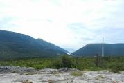
Sra Srang, the most big body of water Angkor makes a strong impression not only at dawn, when the sun paints its waters and stones in crimson tones. In the light of day, the artificial lake, which seems huge, forces the inquisitive mind to look for answers to many questions regarding the art of the elite brought to the highest degree of perfection. Such an ode to irrigation may seem too pompous, but the efforts of numerous research groups, working for many years to study the phenomenon of the irrigation system of the Khmer Empire, have not yet led to the solution of the main mystery. Today, no one can confidently answer how and why this system worked without pumps and lifting devices, sensors and actuators, computer software and local networks. Just a few minutes drive along excellent new road in the direction of the Siem Reap airport will be taken to where, despite the centuries, destruction and disasters, its part continues to serve the descendants of brilliant builders a thousand years after its creation.
Even at the very end of the dry season, when the water leaves the dam for several tens of meters, the view of this man-made sea is amazing. Its shafts are up to 100 meters wide at the base, and their height rises to 20 meters in the west. Now the reservoir is barely two-thirds full, but even this volume of water can hardly be seen. Surrounded by green forests, West Baray stretches from horizon to horizon. In its center, slightly to the right observation deck the main gateway, West Mebon sways in the waves, Bakheng Hill rises to the right, and further, to the east, one can see through the haze of Phnom Bok and a dark strip of forest on the slopes of the Kulen Mountains.
Today's depth of the reservoir allows to accumulate up to 80 million cubic meters of moisture. At the beginning of the 11th century, this figure, apparently, could have been almost twice as much. For many years it was filled only with rains, but after the construction of a dam in the area of the temple of Ta Nei, part of the water from the Siem Reap River began to flow here again. Some researchers believe that barai was navigable. Up the Siem Reap River, which was incomparably more full-flowing at that time, ships and barges from Tonle Sap came here through the canal system and even sea vessels from the Mekong Delta. Just eight hundred meters from the western gate of Angkor Wat was the sea gate of the empire. These assumptions are still awaiting researchers, but the use of the Western Baray as naval base hydroplanes is an indisputable fact, since it was from here that Viktor Viktorovich Golubev flew over the Angkor region. For several months in 1932, he made aerial photography of the territory of the archaeological park, which made it possible to confirm a number of brilliant hypotheses of the Russian scientist.
Judging by the ruins of the Western Mebon temple, which marks the exact geometric center of the reservoir, its construction should have been completed no later than the first quarter of the 11th century. baray entered the existing irrigation system and replaced the ditches that surrounded Yashodharapura on the eastern border. The traces of canals and land roads, the remains of buildings found near the Western Barai dam, structural elements, fragments of tiles, ceramics and copper products, studied on the basis of Golubev’s photographic materials, led to the conclusion that this region was densely populated even before the construction of the reservoir. This is confirmed by the texts of an accidentally discovered stele dating back to 713. According to the epigraphic inscription, Queen Jayadevi, the widow of King Jayavarman I, establishes the boundaries of the rice plots here, which she bestowed on her subjects.
The ruins of Ak Yom temple suggest that at least one of the important shrines was submerged or buried under the outer ramparts of the Western Barai. A stele from Sdok Kak Thoma, which tells the story of a family of priests in the service of the Khmer kings from 802 to 1052, reports that Jayavarman II in the period between the construction of Hariharalaya and Mahendraparvata:
"... founded the city of Amarendrapura and its priest settled there to serve the king."
Georges Koedes suggested that Ak Yem, during the study of which the remains of a fence and a building in the pre-Angkor style were found, was central temple Amarendrapura. For its speedy construction, materials from even more ancient buildings were reused.
Today, the Western Baray, in addition to its enduring role as a major hydraulic structure and historical monument, is also a favorite vacation spot for the local population. Magnificent sandy bottom, gently sloping coast, clear water attract hundreds of Khmer families here. It is noisy and fun here most of the year.
It makes sense to combine an excursion here with a visit to the Ak Yom temple, a water or land trip to the West Mebon temple, as well as an amazingly interesting trip to a silkworm farm.
Skeptics say that in the past there were no civilizations with advanced technologies and incredible structures. Everyone strange artifact or they try to explain the trace of the past from their point of view - they say, this is done by hand, and this is a natural formation.
However, there is such convincing evidence of the presence of advanced civilizations in ancient times that even the most convinced skeptics and rational scientists cannot refute them.
This archaeological complex called Sahasralinga is located on the Shalmala River in the Indian state of Karnataka. When summer comes, and the water level in the river drops, hundreds of pilgrims come here.

It got its name thanks to the numerous (sahasra = thousands) "Lingas" - stone dressings, of the most diverse shapes and sizes, carved on stones.
When the river level drops, a variety of mysterious stone figures, carved in ancient times, are exposed from under the water. For example, this amazing education. Are you saying it's handmade?

2. Caves of Barabar
Barabar is the generalized name of a group of caves located in the Indian state of Bihar, near the city of Gaya. Officially, they were created in the III century BC, again, from the point of view of historians, manually. Is this so, judge for yourself.
In our opinion, to make such a structure of hard stone - with high ceilings, with walls so smooth, with seams that a razor blade cannot penetrate - is very difficult today.


3. South stone Baalbek
Baalbek - ancient city located in Lebanon. It has many different attractions. But most of all, the temple of Jupiter with multi-ton marble columns and the South Stone are surprising - an evenly hewn block weighing 1500 tons.
Who and how could make such a monolith in time immemorial and for what purposes - science does not know the answers to this question.

4. Baray Reservoir
West Baray is a man-made reservoir in Angkor (Cambodia). The size of the reservoir is 8 km by 2.1 km, and the depth is 5 meters. It was created in ancient times. The accuracy of the boundaries of the reservoir and the grandeur of the work performed are striking - it is believed that it was built by the ancient Khmers.

Nearby are no less amazing temple complexes - Angkor Wat and Angkor Thom, the layout of which is striking in its accuracy. Modern scientists cannot explain what technologies the builders of the past used.
Here is what Y. Iwasaki, director of the Osaka Geological Research Institute, Japan, writes:
“Starting from 1906, a group of French restorers worked in Angkor. In the 50s. French experts tried to lift the stones back onto the steep embankment. But since the angle of the steep embankment is 40º, after the first step 5 m high was built, the embankment collapsed. In the end, the French abandoned the idea of following historical technologies and installed a concrete wall inside the pyramid to preserve the earthen structures. Today we do not know how the ancient Khmers could build such high and steep mounds.
5. Cumbe Mayo Aqueduct
Cumbe Mayo is located near the Peruvian city of Cajamarca at an altitude of about 3.3 km above sea level. There are leftovers here ancient aqueduct, which was clearly not made by hand. It is known that it was built before the advent of the Inca Empire.

Curiously, the name Kumbe Mayo comes from the Quechua expression kumpi mayu, which means "well-made water channel." It is not known what civilization created it, but it is believed to have been around 1500 AD.
The Cumbe Mayo aqueduct is considered one of the oldest structures in South America.
Its length is about 10 kilometers. At the same time, if rocks were encountered on the path of the ancient path for water, then unknown builders cut a tunnel right through them. Check out the incredible photos and videos of this structure below.


6. The Peruvian cities of Sacsayhuaman and Ollantaytambo
Sacsayhuaman and Ollantaytambo are the remains of ancient structures in the Cusco region (Peru), on the territory of a huge archaeological park. The area of this park is 5000 square meters, but most of it was buried under an avalanche many years ago.

It is believed that these cities were built by the Incas using the most primitive tools. However, the huge stones of the fortress, tightly fitted to each other, as well as even traces of stone cuts in both ancient cities, are surprising. The Incas themselves were amazed at the grandeur of these buildings.
The Peruvian Inca historian Garcilaso de la Vega wrote about the Sacsayhuaman fortress: “It strikes with the size of the stone blocks of which it consists; one who has not seen this himself will not believe that something can be built from such stones; they inspire horror to those who examine them carefully.
Take a look at its remains and the blocks from Ollantaytambo and see for yourself that it is simply impossible to create this manually, without the help of high technology.


7. Moonstone in Peru
Here, in the Cusco region, in the same archaeological park there is a curious attraction - a stone called Killarumiyoc. This is a Quechua Indian word, which literally means "Moonstone". It is believed that this is a sacred place.
People come here for rituals, meditations and purification of the soul. Pay attention to its unusual perfectly symmetrical shape and incredible quality of finish.


8. Al Naslaa Stone in Saudi Arabia
This famous cut stone called Al Naslaa is located in the province of Tabuk in Saudi Arabia. The ideally even cutting line surprises all researchers - the surfaces on both sides are perfectly smooth.
Who exactly cut this stone and how remains a mystery. Scientists are sure that nature has tried here - they say, this is a perfectly flat line - this is a consequence of weathering. But this version seems untenable - there are no similar formations in nature.

9. Stone Ishi-no-Hoden
Near the Japanese city of Takasago is the famous huge megalith Ishi-no-Hoden. Its weight is about 600 tons. It is known that it was created BC. The stone is a local landmark - and looking at its photographs and old drawings, you understand why it is so popular.


10. Pyramid of Menkaure
The Pyramid of Menkaure (or Menkaure) is located in Giza and is one of the Great Pyramids. At the same time, it is the lowest among them - only 66 m in height (half the size of the pyramid of Cheops). But she strikes the imagination no less than her famous neighbors.
For the construction of the pyramid, huge monolithic blocks were used, the weight of one of them is about 200 tons. It still remains a mystery how it was delivered to the place of construction. The quality of the finishing of the blocks outside and inside the pyramid, as well as carefully crafted tunnels and internal chambers, is also surprising.


In this pyramid in the 19th century, a mysterious basalt sarcophagus was discovered, which was decided to be sent to England. But along the way, the ship got into a storm and sank off the coast of Spain.
However, this is still far from complete list amazing sights, looking at which you want to rewrite the history books. And we will definitely tell about them in other publications on this topic.