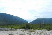
Alps: where are these beautiful mountains located? Map of ski resorts in France.
The Alps are mature mountains, although not as old as the Urals (which are about 350 million years old). The Alps were formed "only" some 40 million years ago, when two giant lithospheric plates - the Adriatic (present-day Africa) and Central European (Eurasia) collided. As a result of the enormous pressure, the rocks of the slabs crumpled like plasticine, and a significant part was squeezed upwards. Thus, the sky-high peaks of a young mountainous country were formed, the glaciation of which occurred only 1.5-1.8 million years ago. Today these mountains are known as the Alps. Together with them, neighboring mountain ranges were formed - the Carpathians, the Pyrenees and the Apennines. With the further "departure" of Africa, the single mountain system was torn, losing its integrity, and the Eurasian plate acquired modern look. The name "Alps", according to some sources, comes from the Celtic word, which means " high mountains".
On the territory of the Alpine mountainous country, Austria and Switzerland are entirely located, and such small states as Liechtenstein and Monaco. The northern parts of the Alps are within the boundaries of Germany, the western - within the limits of France, the southern - Italy. The southeastern ridges enter the territory of Slovenia. Seen from a bird's eye view, the mountain strip of the Alps extends in a semicircle from the Ligurian Sea and breaks off before reaching the Danube. The length of the semicircle along the outer edge is about 1200 km, along the inner edge - about 750 km, the width is from 50 km to 260 km. total area mountain system reaches more than 200 thousand kilometers. The geological history of the Alps is somewhat confused. It looks unusual, and even fabulous, when among the green hills with smooth outlines and cozy little houses huge Mountain peaks. Hills, this type of relief is called the Pre-Alps, composed of limestone, dolomite and flysch. In the mountains, in particular in the Glarn Alps, the remains of older rocks were found, lying on top of younger ones. When the plates collided, the ancient rocks were driven up by flysch, which led to such consequences. Geographically, the mountains are divided into two parts: Western Alps and Eastern Alps, the border between them runs along the valley of the river Rhine.

diagram of the Western and Eastern Alps
The highest mountain ranges are located in the Western Alps, the highest point of which is Mont Blanc. In French, "Mont Blanc" means " white mountain". The peaks of the Alps have always attracted climbers. Many tried to conquer Mont Blanc, but only in 1786 mountain guide Jacques Balm and physician Michel-Gabriel Packard were the first to reach the summit, and a year later Saussure (a Swiss geologist, botanist and climber) organized a large expedition , thanks to which the height of Mont Blanc is measured - 4807 meters.

Following them, scientists, aristocrats, and women rushed to conquer the peaks. It is said that by the end of the 1860s there was not a single peak left in the Alps, where no human foot had set foot. Today, the Alps are considered the most traveled among the mountain systems of our planet. The very word "alpinism" - climbing mountain peaks, clearly indicates the birthplace of this sport, which originated in the Alps at the end of the 18th century. The border of the Eastern Alps with the Western starts from lake constance in the north, runs along the valleys of the rivers Rhine, Liro and Mera to Lake Como in the south. The Eastern Alps differ from the Western Alps in their wider and less high mountain valley. The highest point is Mount Bernina 4049 meters.
mount bernina
It is interesting that the Eastern Alps are homogeneous in origin with the Carpathians and represent a continuation of the Western Carpathians. This is the same mountain fold of the earth's crust, but having met the Bohemian massif, consisting of ancient hard rocks (granite, syenite), the Alps deviated from their original direction, and bypassing this massif, turned sharply to the northeast again and took the direction of the Western Carpathians. The main European rivers begin in the Alps: the Rhine, Rhone, Bar, Po, Ech, tributaries of the Danube. mountain range forms the main watershed of Central Europe, and falling with precipitation, the water is carried by rivers in all directions. Most of the Alpine rivers originate in glaciers (glaciers), there are about 1100 of them, of which the largest are 100. Of these, Aletsch stands out - the most majestic glacier in the Alps.

The waters that flow from glaciers look like muddy streams, they are also called "glacial milk". They quickly descend, forming waterfalls and whirlpools on their way, streams of water rush into the valleys and, passing through the lakes, leave their sediment there and come out clean and transparent. One of the main decorations of the Alps are numerous lakes, which are located on the southern and northern slopes. The largest: Geneva, Como, Baden, there are also small lakes that are surrounded by rocks and are frozen for most of the year.
![]()
small lake formed by a glacier
In addition to high mountains, the Alps also have deep caves. Caves are located in the massifs of the Eastern Alps and there are not so many of them, since the mountain system is still young, mainly karst caves formed by rivers, but there are also ice caves. The largest in the world ice cave is the Eisriesenwelt with a length of 42 kilometers.

Eisriesenwelt cave
It is located in the Salzburg Alps in Austria on the very edge of the Tennen massif. Although the cave is called "ice", but it is formed of limestone, and partially covered with ice, only one kilometer from the entrance. The cave was once formed by a river, and the ice was formed by melting snow that flowed into the cave and froze. The temperature in the cave is kept constant, below zero.
On the slopes of the Alps, altitudinal climatic zonation is clearly expressed, which manifests itself, moving from the warm temperate southern foothills to the harsh high-altitude climate of the upper parts of the mountains with frequent frosts, snowstorms and snowfalls. So, up to about 1000 meters there are many orchards, vineyards and fields. In the belt of 1000-1800 meters the vegetation gradually changes to coniferous forests: spruce and fir forests predominate in more humid areas, pine and cedar forests predominate in drier areas. At altitudes of 1800-2300 meters there are many summer pastures, mostly shrubs grow, meadows prevail. In the highlands, glaciers and snowfields, rocks and stone placers dominate. The Alps, due to their location in the very center of Europe, are one of the most densely populated and accordingly visited mountainous countries on the planet.
Alps- highest mountains Western Europe- occupy part of France, Italy, Switzerland, Germany, Austria, Liechtenstein and Slovenia.
A complex system of ridges and massifs, stretching in a convex arc to the northwest from mediterranean sea to the Middle Danube Plain. The length is approximately 1200 kilometers (about 750 kilometers along the inner edge of the arc). Width up to 260 kilometers. The transverse valley between Lake Constance and Lake Como is divided into the higher Western Alps (height up to 4807 meters, Mount Mont Blanc) and the lower and wider Eastern Alps (up to 4049 meters, Mount Berdina).
In the Alps - the sources of the Rhine, Rhone, Po, Adige, right tributaries of the Danube. Numerous lakes of glacial and tectonic-glacial origin (Bodenskoye, Geneva, Como, Lago Maggiore and others).
The altitudinal zonality of landscapes is well expressed. Up to a height of 800 meters, the climate is moderately warm, on the southern slopes - Mediterranean, there are many vineyards, orchards, fields, Mediterranean shrubs and broad-leaved forests. At an altitude of 800-1800 meters the climate is temperate, humid; broad-leaved forests of oak and beech are gradually replaced by coniferous ones upwards. Up to a height of 2200-2300 meters, the climate is subalpine, cold, with long-term snow. Shrubs and tall grass meadows predominate; summer pastures. Above, to the border of eternal snows, there is an alpine belt with a cold climate, with a predominance of low-grass sparse alpine meadows, covered with snow for most of the year. Even higher - nival belt with glaciers, snowfields, rocky slopes.
The Alps are an area of international mountaineering, tourism, and skiing.
Main ski resorts: Megeve (France), Chamonix (France), Courchevel (France), Zermatt (Switzerland), Grindelwald (Switzerland), St. Moritz (Switzerland), Davos (Switzerland), Lech (Austria), St. Anton ( Austria), Kitzbühel (Austria), Seefeld (Austria), Cortina d'Ampezzo (Italy), Garmisch-Partenkirchen (Germany).
Photos of the mountains of the Alps:
Where are they located on the map:
Our service will help you find out geographical coordinates(latitude and longitude) and height above
sea level of any place in the Alps or any other point on geographical map peace.
Search for geographic coordinates (latitude and longitude) for an address.
If you want to know GPS coordinates s of any building in the alps
you need to enter in the search field (Enter the address) the address of this place and click on the button
search (Find on GPS map coordinates), a marker will appear on the geographical map that will indicate
you the location according to your search query and you will get the geographic coordinates of the point
on the world map (latitude and longitude) in decimal degrees and altitude in meters.
DD stands for (decimal degrees).
You will be able to find a place on the geographical map of the world by DD (decimal degrees) if you already have
geographic GPS coordinates in DD decimal degrees, then enter them in the appropriate
fields (latitude and longitude) and click on the search button (Search for a place), on the geographical map of the world
you will see the marker and its position will correspond to your GPS coordinates in DD decimal degrees.
DMS stands for (degrees, minutes, seconds).
You will be able to find a place on the geographic map of the world by DMS (degrees, minutes, seconds) if you already have
have geographic GPS coordinates in DMS degrees, minutes, seconds, then enter them into the appropriate
fields (latitude and longitude) indicate the cardinal directions you need for (latitude N or S) and for (longitude E or W)
and click on the search button (Search for a place), on the geographical map of the world you will see a marker and its position
will match your GPS coordinates in DMS degrees, minutes, seconds.
If you need to find out the geographic GPS coordinates of any point on the world map, click the left button
computer mouse to the right place on the geographical map of the world and you will get
geographic GPS coordinates (latitude and longitude) of this place, altitude
above sea level in meters, as well as the detailed address of this point on the world map.
If you like our GPS location service and find it useful
for people, please share the link with your friends to our service!
- home
- mountain systems
- Alps
Alps
Description of the Alps
Location of the Alps mountain system on the world map
(the limits of the mountain system are approximate) The Alps are the highest and longest mountain range among systems entirely in Europe. Wherein Caucasian mountains higher, and the Ural ones are longer, but they also lie on the territory of Asia.
The Alps are a complex system of ridges and massifs, stretching in a convex arc to the northwest from the Ligurian Sea to the Middle Danube Lowland.
Where are the Alps located? Coordinates, map and photo.
The Alps are located on the territory of 8 countries: France, Monaco, Italy, Switzerland, Germany, Austria, Liechtenstein and Slovenia. The total length of the Alpine arc is about 1200 km (about 750 km along the inner edge of the arc), and the width is up to 260 km. The highest peak of the Alps is Mont Blanc, at 4,810 meters above sea level, located on the border between France and Italy. In total, about 100 four-thousander peaks are concentrated in the Alps.
The Alpine mountains are one of the main European cities.
Where are the Alps: interesting facts about the mountains
Not only fans come here skiing, but also those who want to enjoy clean air and healing waters from local thermal springs. Eight European countries, in which alpine reefs and arches are located, are participating for the first time in creating attractive conditions for tourists.
How to make an itinerary for visiting the Alps so that you can see all the interesting things for a short vacation?

Iitoria in the mountains
Covered in snow and surrounded by mist peaks of the alpine mountains gave the name to the mountainous area.
It is assumed that it comes from the Latin word "albus" ("white").
Age of the Alpine mountains feature cannot be determined.
Between 34 and 23 million years ago, a tectonic collision occurred that caused the longest European mountain region to emerge. Length of the Alps is 1200 kilometers.
For many years the Alps have been an inevitable natural barrier.
They restricted the movement of trade and military expeditions. locals avoided climbing more high altitude, as they could meet avalanches, storms and frosts.

The study of the Alpine mountains began only in the second half of the 18th century.
Enthusiast scientists studied the flora, fauna, glaciers and geology of the range. At the same time, the term "alpinism" was born, which at that time meant walking on the slopes without special equipment. In 1786 he was first conquered highest alpine mountain— Mont Blanc.
The history of the Alps as a tourist center dates back to the 19th century.
Then rich people came to mountain hotels to enjoy unusual views and swim from the waters of thermal springs. End of XIX. Over the centuries, winter sports have been gaining popularity. In the Alpine mountains there ice rink and ski championships.

The Alpine Mountains were the site of the first Winter Olympics and remain the most popular.
Developed infrastructure suitable weather and the availability of modern sports facilities have always offered locations in the Alps for the Winter Olympics.
Today the highlands are one of the largest in the world. tourist centers. More than 100 million people visit these places every year. Nature of the Alps not only attracts lovers extreme species sports.
Fresh air, healing properties of springs and unique local culture provide a constant flow of tourists at any time of the year.

Attractions in the Alps
Most tourists go to the Alpine mountains to enjoy unique views, try their hand at the mountainside and swim in the local resources.
But the Alpine region is a place where several European cultures meet at the same time. There are interesting objects with architectural, historical and religious value.

Prices for flights and tickets
In the immediate vicinity of the Alpine mountains there is no major airports.
Airlines sometimes organize flights to Bolzano (Italy) and Innsbruck (Austria), but these connections are seasonal. Most tourists prefer to book a ticket to one of the nearest major airports, and the rest of the route is taken by bus or train.
The Alpine Mountains are easier to reach from international airports located in the following locations:
- Munich;
- Milan;
- Verona;
- Innsbruck;
- Salzburg;
- Venice;
- Vein;
- Bolzano;
- Bologna;
- Klagenfurt;
- Friedrichshafen;
- Bergamo;
- Brescia.

The most suitable routes for Russian tourists are the airports of Munich and Milan.
They are associated with regular flights with major cities Russia. Depending on the distance from the selected Alpine settlement, the route from the airport can take from 1 to 2 hours.
The journey from Munich to the popular ski region can be overtaken by road: the city is connected to the Alps with three modern buses.
From Munich Airport to the mountains, it is advisable to get to the S-Banh suburban line. In this case you will be in 40 minutes.

If you decide to visit the western part of the Alps, your trip will take place at the airports of Milan or Verona.
Milan has good communication with Russian cities, but you still need to get to the Alps through Verona. If you don't find a direct flight to Romeo and Juliet, don't give up: the Milan route will be comfortable. In both international airports Milan direct Milan buses are at Milan station where you can buy a ticket to Verona.
The trip from Verona to the Alps can be beaten by car, traveling on a two hour trip or by train.
Trains run from 5.00 to 22.00, every half an hour they are cured from the platform. Tickets cost from 10 euros, and they will have to spend 1.5-2 hours on the road.
![]()
Alps
Alps(French les Alpes, German die Alpen, t. le Alpi, Slovenian Alpe, from lat.  montes albes - white mountains, the name of Celtic origin is also possible alb - high, or alpa - hill) - the highest mountain system in Western Europe, extends in an arc from the shores of the Mediterranean Sea to the Middle Danube Lowland on the territory of European countries Austria, Italy, Liechtenstein, Germany, Slovenia, France, Switzerland.
The length of the mountain system is 1200 km, width - 130-260 km, height up to 4807 m (Mount Blanc). The arc is convex to the northwest with a transverse depression, within which lie Lakes Constance and Como. There are Western and Eastern Alps.
Division of the Alps
The Western Alps consist of the Maritime, Kotsky, Savoy, Bernese Alps. Their average height is 3.000-4.000 m. Individual peaks reach more than 4000 m:
Mont Blanc (the highest peak of the Alps and Europe) 4.809 m,
Monte Rosa 4.638 m,
Weisgorn 4.512 m and others.
The Western Alps are characterized by a well-discovered arched shape of the ridges, a sharp asymmetry of slopes - inner steep, outer gentle, a large development of glaciers.
In the Eastern Alps, the Bernese, Rhaetian, Dolomitic and Carnic ridges, which extend in width, stand out especially.
The average height of the Eastern Alps is 2.500-3.500 m, there are also fewer glaciers.
In addition to the division into Western and Eastern, the Alps are also divided in the latitudinal direction: into the Northern Prealps - (limestone and shale mountains), the Central Alps - (crystalline ridges) and the Southern Prealps - (limestone and sandstone mountains).
The Alps were formed during the day of the Alpine folding.
The axial zone of the Alps is composed of crystalline and metamorphic rocks, along the periphery - flysch and molas formations. Deposits of iron, manganese, magnesite and polymetallic ores, rock salt (in the Eastern Alps).
Also insignificant deposits of brown and hard coal. The Alps have numerous spring outlets mineral water including warm, on the basis of which resorts were built (Baden-Baden, Bad Weslau, Badgastein, Ischl, Reichengal, Ex-Lebena and others).
About 1.200 glaciers ( with total area over 4000 km2). There are many lakes of tectonic-glacial origin.
Where are the Alps located?
The Alps have many convenient passes - Mont Cenis, St. Bernard, Simplon, St. Gotthard, Bernina, Brenner, Tauern. Tunnels were laid through the Alps: Simplonsky, St. Gotthard and others.
The climate and soil and vegetation cover of the Alps have a clearly pronounced vertical zonality: up to 1200 m the climate is moderately warm, broad-leaved forests grow; from 1300 to 1700 m the climate is temperate, the vegetation is coniferous forests; 1700-2300 m - subalpine zone; 2300-3200 m - alpine zone with a temperate cold climate, above - the zone of eternal snow.
highest peaks
4.809 m: Mont Blanc
4.478 m: Matterhorn, Apennine Alps
3.970 m: Eiger, Bernese Alps
4.166 m: Jungfrau, Bernese Alps
Rivers
Rhine
Rhone
Po, a tributary of the upper Danube;
lakes
Geneva
garda
Lago Maggiore
Constance
Glaciers (glaciers)
The line of eternal snow lies in the north at an altitude of 2.500 m, and in the south - 3.000-3.200 m.
The total area of modern glaciation is 4140 km2. Glaciers in the Alps approx. 1200, the largest is Aletsch in the Bernese Alps with an area of 169 km2. Rivers originate from glaciers: Rhone, Rhine, Adi-je, Inn, Drava, etc.
About 1200 glaciers (the largest is Aletsch);
Main rail and road routes
Mont Cenis, Simplon, Saint Gotthard, Arlberg, Brenner, Semmering;
tourism, winter sports, mountaineering.
Geography of Italy
 Italy map Topographic map Italy Italian cities and shtetl Photo from space.
Southern Italy and Sicily on the map 1849 p. Italy (Italia) is a state in the south of Europe, in the Mediterranean. DETAILS
Western Alps
Western Alps, part of the Alps mountain system.
Located west of a line running from Lake Constance north to Lake Como south, within Italy, France and Switzerland. Western Alps - the most DETAILS
Kotian Alps
 Monte visa Cotes Alps (fr. Alpes Cottiennes t. Cozie) - mountains, part of the Western Alps in France and Italy. The Kotian Alps are separated from the Alpes-Maritimes (in the south) by the Larcher Pass (Maddalena), DETAILS
Graian Alps
Graian Alps Graian Alps
Alpes Grees (Graies), t. Alpi Graie mountains, part of the Western Alps in France (Savoie), Italy (Piedmont and Valle-Daosta) and Switzerland (west of the Valais canton).
Lepontine Alps
Lepontinsky Alps (Italian: Alpi Lepontine mountains, part of the Western Alps in Switzerland (cantons of Valais, Ticino and Grisons) and Italy (Piedmont).
The Lepontinsky Alps are separated from the Bernese Alps (more
Eastern Alps
 Eastern Alps, part of the Alps mountain system. To the east of the line passing through the Alps from Lake Constance in the north along the valleys of the rivers Rhine and Posterior Rhine to the Splügen Pass, the year of Liro and Peace to the lake MORE DETAILS Our site was created for those who want to gain knowledge.
There are so many more interesting things, places, thoughts, bright ideas in our world that you need to know about!

Where are the Alps located? ALPINE MOUNTAINS
Coordinates, map and photo.

The Alps are located in Central Europe
and are located in the territories of southern Austria, northern Italy, the southern half of Switzerland and the eastern outskirts of France.
On the map below, the Alps are highlighted in a darker color than the adjacent plains. To see the snow-covered ridges of the Alps, switch the map to satellite mode in its upper corner.
Coordinates:
46.5082512
northern latitude
10.8489056
east longitude
Alps on the interactive map which can be controlled:
Alps are on the list: mountains
And do not forget to subscribe to the most interesting public VKontakte!
correct/add
© 2013-2018 Site interesting places where-is.rf
The Alps are one of the largest mountain ranges in Europe, extending from Austria and Slovenia to the east
The most high peak Alpe Mont Blanc 4807 m high, the Alps are on the Franco-Italian border.
The Alps are usually divided into Western and Eastern, the division runs along the line between Lake Como and Lake Constance, along the river Rhine. The western Alps are located in Italy and France, while the eastern Alps are located in Austria, Germany, Italy, Liechtenstein and Slovenia. In Switzerland, both parts.
The highest point of the western part is Mont Blanc in France (4807 m), followed by Monte Rosa (4634 m) and Matterhorn in Switzerland (4478 m) and Bernina Italo-Swiss border (4052 m). The Alps are 1000 km long and up to 250 km wide. 28.5% of the Alps are located in Austria, followed by Italy (27.2%) and France (20.7%).
View of the Alps
The Matterhorn in Switzerland is one of the most famous Alpine peaks.
The Alps have a total of 82 peaks over 4000 m, 55 of them entirely in Italy, France and Switzerland, and 27 are frontier.
Rivers and lakes
Most long rivers that flow through the Alps yin and Drava. The lakes in the Alps were formed by ancient glaciers, there are more glaciers, but they are only the tops. The most beautiful lakes in the Alps are Lago di Maggiore, which comes from the course of the Po River and Lake Garda, located on the banks of the Adige River.
Climate
The climate is mountainous. The average annual rainfall in the Alps is 1450 mm.
The Alps are divided into five climatic zones, each with a different type of medium. Climate, plants and animals are different in different parts or areas of the mountain.
The area that is over 3,000 m is called the "glacial snow zone". This area, which is the coldest climate, is constantly covered with compressed snow.
Alpine tundra is located at an altitude between 2000 and 000 m 3. This zone is warmer than the Neva area. Here you can find wild flowers and herbs.
A little lower is the subalpine belt - from 1500 to 2000 m above sea level. Here the temperature slowly rises up, began to meet with fir and spruce forests.
At an altitude of approximately 1000 to 1500 m, arable land is occupied. Oak forests are common in this area, but also a place for agricultural production.
Below 1000 m lowland. There is a much greater variety of plants. Human settlements are also in the lowlands, because the temperature is more tolerable - both for people and animals.
Nature
The vegetation zones in the Alps gradually changed with the ascent of the mountain. The natural height limit of vegetation is determined by the main types of deciduous trees - oak, beech, ash and plane tree. They do not reach the same level, or even often come together, but their upper limit matches exactly enough to make the transition from temperate to cold climates, which is also evidence of a change in herbaceous vegetation. This limit is usually located at about 1200 m above sea level - on the northern side of the Alps, while the southern slopes often rise to 1500 m, sometimes even up to 1700 m.
This area is not always marked by the presence of characteristic trees. Human intervention has almost wiped them out in many areas, with the exception of beech forests on the Austrian Alps, deciduous forests are rare. In many areas where it once existed such forests have now been replaced by pines and spruces, which are less vulnerable to the destruction of goats, which are the worst enemies of such trees.
The forests are often small, squat, which in turn has been replaced by shrubs - usually rhododendron ferrugineum (on more acidic soils), or rhododendron Hirsutum (on more alkaline soils). Above them are alpine meadows, and even higher the vegetation becomes more and more sparse. In the Alps recorded some plants over 4,000 m, including Ranunculus glacialis (buttercup type), Androsace Alpina and Saxifraga biflora.
The most common animals in the Alps are the alpine marmots. In addition, eagles, Alpine goat, chamois, Cory crow, Alpine zavirushka, bearded vulture, brown bear, lynx, deer, wolf and tundra partridge. There are 14 national parks in the Alps, which comprise about 30,000 animal species.
Story
In 1991, a preserved mummy of a man who lived around 3300 BC was found in the Alps. In 218 BC The Carthaginian commander Hannibal launched a campaign into Gaul and the Alps with an army and war elephants to invade the Roman Empire from the north. About half of the soldiers who die during the transition period. However, Hannibal won the battle of Ticino.
In 46 / 47, the Romans built the first Roman road in the Alps - Via Claudia Augusta - Connecting Augsburg (then Augusta Castra) to Venice through the Alps, through the passage is settled. The road was wide enough for quads to pass. Many roads were built in the Alps. For the XI century, many of them were destroyed.
In the 18th century, many new roads were built to allow traders to quickly transport goods and quickly carry weapons during the Napoleonic Wars.
On May 16, 1854, the first railway line in the Alps opened - between Vienna and Graz. In 1882, the 15-mile Gotthard Tunnel was opened, through which trains from Lucerne to Milan were opened. Thus, the transit time is reduced by several days from eight to ten hours. Today, it's less than four hours by train and less than three hours by car.
On September 23, 1910, the Peruvian-French aviator Geo Chávez became the first to fly over the Alps, but crashed shortly before landing. In 1913, the Swiss Oskar Bider duplicated the field and landed successfully.
On December 24, 1934, the first modern ski lift opens in Davos. The first season has been used since October by 70,000 tourists. In 1908, the first cable car was put into operation in Bolzano. In 1974 the first motorway through the Alps was completed connecting Innsbruck and Modena.
Where are the Alps located?
The majestic mountain range in Europe will give amazing moments on fresh air and breathtaking panoramic views. Imagine emerald alpine lakes, idyllic villages and valleys that provide Swiss quality service and amenities. We will show you the most Beautiful places in the Alps. And each of these idyllic alpine places is a must-see.
Thermal Spa Bad Gastein, Austria
Excellent treatment centers are based in resort town Gastein, which is located in the Austrian Alps. It is also a popular ski area. Baths and pools use fresh water from hot springs located in the mountains. Great service here beautiful nature and relaxing spa treatments.

Photo: Yisong Yue

Photo: Robert Dohler

Photo: Thomas Wenger (https://creativecommons.org/licenses/by-sa/2.0/)
Stelvio Pass, Italy
Second of the highest passes in the Alps - exceptionally beautiful place. The road connects the Stelvio in South Tyrol with Bormio. The pass was built during the time of the Austrian Empire, in the 1820s, and has hardly changed since then. Stelvio is a traditional Tyrolean region. Here you can visit quiet, picturesque alpine villages. There are also ski resorts.
The historic road is one of the most famous not only in the Alps, but also in the world. The view from here is magnificent, and the classic winding route is very popular with extreme drivers. The British show "Top Gear" called it the greatest road in the world.

Photo: jockrutherford (https://creativecommons.org/licenses/by-sa/2.0/)

Photo: jockrutherford (https://creativecommons.org/licenses/by-sa/2.0/)

Photo: Iain Cameron (https://creativecommons.org/licenses/by/2.0/)
Gran Paradiso National Park, Italy
The stunning park is named after the Gran Paradiso mountain in the Alps, in northwestern Italy. The park impresses with its landscape, valleys, glaciers and alpine meadows. Endangered species of animals and birds live here. This is an alpine mountain goat, chamois, eagle owl and many others. Small villages are scattered in the park.
Many come here to climb the mountains and enjoy the magnificent views. In addition, you can watch wild animals and birds here. wild nature so rich, it doesn't take much effort to find the "locals".

Photo: Fulvio Spada (https://creativecommons.org/licenses/by-sa/2.0/)

Photo: Fulvio Spada (https://creativecommons.org/licenses/by-sa/2.0/)

Photo: Soumei Baba (https://creativecommons.org/licenses/by/2.0/)
Aiguille du Midi, Chamonix, France
Another stunning place to visit is the Mont Blanc region. The height of the peak of the Aiguille du Midi is 3842 meters. When viewed from Chamonix, at noon the sun is directly above this peak. The Aiguille du Midi cable cars will take you to a height of 3800 meters. From here with viewing platforms offers unforgettable views of the surroundings. A glass platform was installed here last year. And although the glass panels are of solid thickness, only the brave ones visit it.
A wonderful place to visit in Chamonix. This is the highest attraction in Europe. Chamonix is a truly classic city with an alpine landscape that tourists love so much.


Dam on Lake Sylvenstein, Upper Bavaria, Germany
The artificial lake fits into the Alpine landscape and is one of the most interesting places in the Isar valley. Located at an altitude of 750 meters in the Karwendel Alps, the lake is replenished by the waters of the Isar River. It is surrounded by hiking trails, which are very fond of tourists. And the dam is a picturesque feature. Driving along it, you can admire the fabulous surroundings.
Tourists come here to go hiking, climbing or swimming in the lake. Popular cycle track Bavaria Tirolensis on the south coast links Bavaria and the Tyrolean Alps. This idyllic place is very popular with photographers.

Photo: Polybert49 (https://creativecommons.org/licenses/by-sa/2.0/)

Photo: Sascha Sormann

Photo: FHgitarre (https://creativecommons.org/licenses/by/2.0/)
Paragliding school in France
The paragliding school accepts beginners and young people. In winter it is a ski resort, but in summer it is a paradise for paragliders. Flying in the Alps - the largest mountain range in Europe - is really something incredible.

Photo: Ludovic Lubeigt (https://creativecommons.org/licenses/by-sa/2.0/)

Photo: SNappa2006 (https://creativecommons.org/licenses/by/2.0/)

Photo: Stefan Schmitz (https://creativecommons.org/licenses/by-nd/2.0/)
Brienz-Rothorn Rack Railway, Switzerland
The scenic area opens up from a train making a slow ascent to the Brienz-Rothorn mountain in the Emmental Alps. Highest point railway located at an impressive height - 2244 meters. The drive passes through a tunnel carved into the rock and makes spectacular loops. Those who are nervous about heights - challenge yourself, you will be delighted!
The journey to the top takes about an hour. There you will be met by restaurants and guest houses where everyone is warmly welcomed. During the walk you can admire the surroundings. There is a road between stations.

Photo: Martin Abeglen (https://creativecommons.org/licenses/by-sa/2.0/)
Stanserhorn, Switzerland
The height of the "most friendly mountain" is 1898 meters. It is accessible to everyone, therefore it is a popular place among tourists. You can get to the top by cable car or along hiking trails. Both methods provide breathtaking panoramic views of the mountains and valleys.
The peak is the best point from which breathtaking views of the surroundings open up. Hiking trails provide great opportunity nice to spend the day outdoors.

Photo: Konrad Summers (https://creativecommons.org/licenses/by-sa/2.0/)
Source: placestoseeinyourlifetime.com
Here is a detailed map of the Alps with street names in Russian and house numbers. You can easily get directions by moving the map in all directions with the mouse or by clicking on the arrows in the upper left corner. You can change the scale using the scale with the "+" and "-" icons located on the right side of the map. The easiest way to adjust the image size is by rotating the mouse wheel.
What country is Alps in?
Alps is located in Spain. It's wonderful beautiful city with its own history and traditions. Alps coordinates: northern latitude and eastern longitude (show on a large map).
virtual walk
interactive map Alps with sights and other tourist sites - an indispensable assistant in independent travel. For example, in the "Map" mode, whose icon is located in the upper left corner, you can see the city plan, as well as detailed map highways with track numbers. You can also see the railway stations and airports of the city marked on the map. Nearby you see the "Satellite" button. By turning on the satellite mode, you will see the terrain, and by zooming in, you can explore the city in great detail (thanks to satellite maps from Google Maps).
Move the "little man" from the lower right corner of the map to any street in the city, and you can make virtual walk over the Alps. Adjust the direction of movement using the arrows that appear in the center of the screen. By turning the mouse wheel, you can zoom in or out on the image.