Between which seas is the Caucasus Mountains. The Caucasus Mountains are one of the most beautiful mountains in the world.
In Russia, there are regions with stunning mountain landscapes. The highest and most impressive peaks are located on the Main Caucasian Range. Throughout the mountain range, the peaks are distinguished by their height and massiveness. The direction of the ranges of the Caucasus Mountains is from northwest to southeast.
Caucasian region
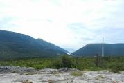
Where do you think the Caucasus is located? This amazing mountainous area is located between the Black and Caspian Seas. It includes the mountains of the Greater and Lesser Caucasus. The Caucasus Range includes the Riono-Kura depression (depression), the coast of the two seas mentioned above, the Stavropol Upland, a small part of Dagestan, that is, the Caspian lowland, as well as part of the Kuban-Azov slopes.
The main peak of the ridge is the snow-white Mount Elbrus. The whole system of the main Caucasian ridge occupies approximately 2600 km². The northern slope covers about 1450 km², and the southern one - about 1150 km². Now let's take a closer look at the description of the mountain range.
Description of the Greater Caucasus Range
lovers extreme sports, be it climbers or mountain skiers, have chosen this place for a long time. Those who traveled through the mountains of the Caucasus return to these places again. Thrill-seekers come here from all over the world for thrills.
The main Caucasian ridge, the photo of which is presented in the article, divides the Caucasus into two historical and cultural regions: Northern and Southern. You can find the ridge on the map between the Black and Caspian Seas. For convenient viewing, the mountain range is usually divided into 7 parts:
- Black Sea Caucasus (from Anapa to Oshten - 265 km).
- Kuban Caucasus (from Oshten to the source of the Kuban - 160 km).
- Elbrus Caucasus (from the source of the Kuban to the peak of Adai-hokh - 170 km).
- Terek Caucasus (from Adai-khokh to the city of Barbalo - 125 km).
- Dagestan Caucasus (from Barbalo to the top of Sari-Dag - 130 km).
- Samur Caucasus (from Sari-dag to the city of Baba-dag - 130 km).
- Caspian Caucasus (from Baba-dag to the top of Ilkhi-dag - 170 km).

As you can see, 7 regions of the Greater Caucasus Range are divided into approximately equal sections in length.
The height of the mountains is varied: it ranges from 260 to 3360 meters. The climate in these places is light and mild, and in combination with beautiful landscapes, this corner of the planet becomes perfect place for outdoor activities in winter and summer.
The Caucasian Range is mainly composed of limestone. In ancient times, this place was located on the ocean floor. Today, if you look at the mountain range from a bird's eye view, you can see the folds of mountains, a huge number of glaciers, active rivers and deep lakes. High basins can be observed along the entire length of the mountain range.
A few words about the northern slope
This side of the Main Caucasian Range is well developed. It is formed from a large number of spurs that adjoin at an angle of 90̊ to the main ridge. The Elbrus fault zone separates the waters of the Caspian Sea and the Kuban. Further, this section decreases in ledges and gently passes into the mountains of Pyatigorsk, as well as the Stavropol Upland.

More developed mountains are located on the northern slope of the Caucasus mountain range on the eastern side, where Dagestan is located. Heading north, they descend, from there they begin mountain ranges called the Black Mountains. They are gentle and long slopes. Why do you think they were called Black? The thing is that their slopes are covered with dense and impenetrable forests. The height of the Black Mountains is insignificant. However, there are peaks in this area, the height of which reaches 3500 meters. Such peaks include Kargu-Khokh, Vaza-Khokh and others.
Information about the southern slope
Compared to the northern slope, the southern one is much less developed, especially the eastern and western parts of the Caucasus Range. Looking at the map, you can read that this section of the mountain range is adjoined by hills that form the longitudinal valleys of the Enguri, Rioni, and Tskhenis-Tskhali. To the south of the mountain range there are very long spurs that separate the basins of the Alazani, Kura and Iori rivers.

The steepest section of the southern side of the ridge is Mount Zagatala. Its height reaches 3 km above sea level.
Otherwise, the Main Caucasian Range from the south side is passable, with the exception of two passes: Cross and Mamison. Roads across the range are accessible almost all year round. In some places they resemble pack trails.
The Cross Pass is of great importance in this area, as the Georgian military road passes through it.
About glaciers
Few people suspect, but the size, number and area of the glaciers of the Caucasus Range, the photo of which is given in the article, are practically not inferior to the glaciers of the Alpine Mountains. Their largest number is concentrated in the region of the Elbrus and Terek ridges.

There are about 183 glaciers of the first order in the basins of the Kuban, Rioni, Terek and Inguri rivers. And there are several times more glaciers of the 2nd category - about 680. In the Soviet years, extensive research was carried out in the Caucasus, as a result of which geologists compiled the Catalog of Glaciers of the USSR. Soviet scientists in the early 80s counted 2050 glaciers. Them total area was almost 1500 km2.
As for the glacial dimensions of the Caucasus Range, there is no unequivocal answer. Their area is varied. For example, the Bezengi glacier is almost as large as the Alechsky glacier, which is located in the Alps. The Caucasian masses of ice, unlike the Alpine ones, never descended low. The most famous are the Bezengi, Chatyntau, Tsey, Big Azau and Tsaneri glaciers. Bezengi is the largest glacier in the Caucasus Range. Its length is 17 km.
During the Ice Age, the ice masses of the range were larger and more numerous than they are today. In our time, they are in the stage of retreat, which has been going on for more than a dozen years.

Bezengi
This is a mountainous region located in Kabardino-Balkaria. It is considered the central range, as well as one of the highest parts of the Caucasian chain. It includes the Bezengi wall. It is a 42-kilometer array of mountains. This is a high section of the ridge. The borders of the Bezengi Wall are considered from the west - the peak of Lyalver, and from the east - Mount Shkhara.
From the north, the Bezengi wall abruptly breaks up to 3 thousand meters in the direction of the Bezengi glacier. In Kabardino-Balkaria it is also called Ullu-Chiran. On the Georgian side, the relief is complex, there is even a glacial plateau. The most significant peaks of the region are the Bezengi Wall, Yesenin Peak, Shota Rustaveli Peak, Lyalver, Dzhangitau and others.

The main peak of Georgia
The highest point in Georgia is Shkhara Peak. Its height above sea level is 5193 meters, but some researchers claim that it is higher - 5203 m. The mountain peak is located about 90 km north of the city of Kutaisi. Shkhara is the third highest peak in the Caucasus and Russia.
The mountain is composed of schist and granite. Its slopes are covered with snow-white glaciers: on the north side - the Bezengi glacier, and on the south - Shkhara. This place is popular among climbers. The first ascent of this mountain was made in 1933. The hill is also notable for the fact that on the side of the southern slope at an altitude of 2000 meters there is a village that is included in the UNESCO list.
Tsey glacier
And now let's talk about the glacier, which is located in the North Caucasus. The Tsey glacier is one of the largest and lowest descending glaciers in the Caucasus. You can find it in North Ossetia. It feeds on snow from the top of Adai-Khokh. The height of the glacier is about 4500 meters. It descends to a height of 2200 m above sea level. Firn fields, consisting of grain snow, reach about 9 km. Below the glacier is narrow, and the higher it is located, the more it expands. It is constrained by rocks, so it is dotted with cracks, and there are also icefalls.
The Tsey glacier consists of large and small branches. There are four in total. There is also a river that flows out of a beautiful ice arch. Its channel passes through scenic spots, rich in centuries-old pines. Nearby there is a camp site "Ossetia", climbing camps, hotels, a weather station and the Caucasian Mining and Metallurgical Institute. Two cable cars are laid to the glacier. About it great place Yuri Vizbor wrote poetry. The local peoples composed legends, songs and tales a lot about the glacier.
Mount Achishkho
This mountain range is located on the side of the western Caucasus. Refers to Krasnodar Territory. The height of the mountain reaches 2400 meters and is located 10 kilometers from Krasnaya Polyana. This ridge differs from all others in its rock composition. It consists of shale and volcanic rocks. The landscapes have ancient glacial landforms, karst lakes and even waterfalls. The mountains are surrounded by a humid climate, with up to 3 meters of precipitation per year. It is considered the largest value in Russia. The snow cover is about 10 meters. As you may have guessed, there are very few sunny days a year in this mountainous corner - no more than 70 days.
The slopes of Mount Achishkho on the north side are covered with fir forests. Mountain meadows are located on the peaks, broad-leaved and beech forests grow on the other sides. This place is popular among hikers. Here you can find dolmens - stone buildings of ancient peoples.

biosphere reserve
On the territory of the Western Caucasus there is a reserve, its total area reaches about 300 thousand hectares. In February 1979, the UNESCO organization decided to assign biosphere status to the reserve.
In 2008, he was named after Kh. G. Shaposhnikov, the founder of the Caucasian Reserve. But he became famous not only for this, but also for his perfect discoveries in the field of biology. At the beginning of the 20th century, the scientist noticed that the Caucasian bison was disappearing in this area, so in 1909 he wrote a letter to the Russian Academy of Sciences with a request to equip the reserve. But since the land belonged to the Kuban Cossacks, things did not move forward for a very long time. The scientist made several attempts, and 10 years later, namely in 1919, things got off the ground. In 1924, the bison reserve began to function.
Conclusion
We have traveled from the foot of the Black Sea Mountains to the Caspian peaks. Thus, the length of the Caucasus Range is 1150 km. Now you know that it is divided into Northern and Southern historical and cultural regions. The total length of the ridge is divided into 7 parts, each of which has almost the same length. Each mountain region is characterized in its own way.
Those who are planning to make a trip should definitely visit the Caucasus Mountains. You will remember these fabulous landscapes for a lifetime. Terrenkur, rock climbing, river rafting, skiing and many other outdoor activities offer tourists the Caucasus.
Caucasian mountains
The Caucasus Mountains are located on the isthmus between the Caspian and Black Seas. The Kuma-Manych depression separates the Caucasus from the East European Plain. The territory of the Caucasus can be divided into several parts: Ciscaucasia, Greater Caucasus and Transcaucasia. In the territory Russian Federation only Ciscaucasia and the northern part of the Greater Caucasus are located. The last two parts together are called the North Caucasus. However, for Russia, this part of the territory is the southernmost. Here, along the crest of the Main Range, passes state border Russian Federation, followed by Georgia and Azerbaijan. The entire system of the Caucasus Range occupies an area of approximately 2600 m2, with its northern slope occupying about 1450 m2, while the southern one is only about 1150 m2.
North- Caucasian mountains comparatively young. Their relief was created by different tectonic structures. In the southern part there are folded-block mountains and foothills of the Greater Caucasus. They were formed when deep trough zones were filled with sedimentary and volcanic rocks, which were later subjected to folding. Tectonic processes here were accompanied by significant bends, extensions, ruptures and faults of earth layers. As a result, a large amount of magma poured onto the surface (this led to the formation of significant ore deposits). The uplifts that took place here in the Neogene and Quaternary periods led to the elevation of the surface and the type of relief that exists today. The rise of the central part of the Greater Caucasus was accompanied by the lowering of the layers along the edges of the ridge being formed. Thus, the Terek-Caspian trough was formed in the east, and the Indal-Kuban trough in the west.

Often the Greater Caucasus is presented as the only ridge. In fact, this is a whole system of various ridges, which can be divided into several parts. The Western Caucasus is located from Black Sea coast to Mount Elbrus, then (from Elbrus to Kazbek) follows the Central Caucasus, and to the east from Kazbek to the Caspian Sea - the Eastern Caucasus. In addition, two ridges can be distinguished in the longitudinal direction: Vodorazdelny (sometimes called the main one) and Lateral. On the northern slope of the Caucasus, the Rocky and Pasture Ranges, as well as the Black Mountains, are distinguished. They were formed as a result of the interbedding of layers composed of sedimentary rocks of different hardness. One slope of the ridge here is gentle, and the other breaks off rather abruptly. As you move away from the axial zone, the height of the mountain ranges decreases.
The chain of the Western Caucasus begins at the Taman Peninsula. At the very beginning, it is rather not even mountains, but hills. They begin to rise towards the east. The highest parts of the North Caucasus are covered with snow caps and glaciers. The highest peaks of the Western Caucasus are the Fisht (2870 meters) and Oshten (2810 meters) mountains. The highest part mountain system The Greater Caucasus is the Central Caucasus. Even some passes at this point reach a height of 3 thousand meters, and the lowest of them (Cross) lies at an altitude of 2380 meters. Here are the highest peaks of the Caucasus. So, for example, the height of Mount Kazbek is 5033 meters, and the two-headed extinct volcano Elbrus is the most high peak Russia.

The relief here is strongly dissected: sharp ridges, steep slopes and rocky peaks prevail. Eastern part The Greater Caucasus is mainly made up of the numerous ranges of Dagestan (in translation, the name of this region means "mountainous country"). There are complex branching ridges with steep slopes and deep canyon-like river valleys. However, the height of the peaks here is less than in the central part of the mountain system, but still they exceed the height of 4 thousand meters. The uplift of the Caucasus Mountains continues in our time. Quite frequent earthquakes in this region of Russia are connected with this. To the north of the Central Caucasus, where the magma rising along the cracks did not spill onto the surface, low, so-called island mountains formed. The largest of them are Beshtau (1400 meters) and Mashuk (993 meters). At their base there are numerous sources of mineral waters.
The so-called Ciscaucasia is occupied by the Kuban and Tersko-Kuma lowlands. They are separated from each other by the Stavropol Upland, the height of which is 700-800 meters. The Stavropol Upland is dissected by wide and deeply incised valleys, gullies and ravines. At the base of this area lies a young slab. Its structure is made up of Neogene formations covered with limestone deposits - loess and loess-like loams, and in the eastern part there are also marine deposits of the Quaternary period. The climate in this area is quite favorable. Quite high mountains serve as a good obstacle to the cold air penetrating here. The proximity of the long cooling sea also has an effect. The Greater Caucasus is the border between two climatic zones - subtropical and temperate. On the Russian territory, the climate is still moderate, but the above factors contribute to rather high temperatures.
Mountains of the Caucasus As a result, winters in Ciscaucasia are quite warm ( average temperature in January is about -5°С). This is facilitated by those coming from outside Atlantic Ocean warm air masses. On the Black Sea coast, the temperature rarely drops below zero (the average January temperature is 3°C). AT mountainous areas the temperature is naturally lower. Thus, the average temperature in the plains in summer is about 25°C, and in the upper reaches of the mountains - 0°C. Precipitation in this area falls mainly due to cyclones coming from the west, as a result of which their amount gradually decreases towards the east.
Most precipitation falls on the southwestern slopes of the Greater Caucasus. Their number on the Kuban Plain is about 7 times lower. In the mountains of the North Caucasus, glaciation is developed, in terms of the area of \u200b\u200bwhich this region ranks first among all regions of Russia. The rivers flowing here are fed by water formed during the melting of glaciers. The largest Caucasian rivers are the Kuban and Terek, as well as their numerous tributaries. Mountain rivers, as usual, are fast-flowing, and in their lower reaches there are swampy areas overgrown with reeds and reeds.
State budgetary educational institution secondary general education high school No. 509 of the Moscow region
city of St. Petersburg
ESSAY
in the discipline "Geography"
on the topic: « Caucasian mountains».
Completed: students of grade 8 "A"
Gaisyonok Julia
Ahmedova Rukiyat
Leader: geography teacher
Kovaleva Natalya Nikolaevna
St. Petersburg 2012
1. Introduction. …………………………………………………………...........3
2.Main part
2.1 Legend about the origin of the Caucasus Mountains………………………...4
2.2 Physical and geographical location………………………………..5
2.3 Climate……………………………………………………………………7
2.4 Rivers and lakes…………………………………………………………...8
2.5Animal world ………………………………………………………..9
2.6 Plant world…………………………………………………....11
3.Conclusion……………………………………………………………..12
4. References…………..…………………………………….…..13
5..Appendix 1……………………………………………………………14
6.Appendix 2…………………………………………………………….16
1. Introduction
Since ancient times our Russian Parnassus
Drawn to unfamiliar countries,
And most of all, only you, the Caucasus,
It rang with a mysterious mist.
S.A. Yesenin
This is amazing land, one of the most interesting regions the globe. Combining unique landscapes, becoming the homeland for hundreds of nationalities, it is truly a unique region of the world. The North Caucasus is my homeland which I love.
The pride of the Caucasus is its mountains! The Caucasus is not the Caucasus without mountains. The mountains are unique, majestic and impregnable. The Caucasus is amazingly beautiful. He is so different. You can look at the mountains for hours.
The Caucasus Mountains are the great divide between Europe and Asia. The Caucasus is a narrow strip of land between the Black and Caspian Seas. It strikes with an incredible variety of climate, flora and fauna.
Green hills and alpine meadows of the Caucasus, salt deserts, miniature sand dunes replaced by high mountains. The beauty of Caucasian landscapes is not inferior to any region of the planet.
The mountain range of the Greater Caucasus is a lot of pastures, forests, as well as amazing natural wonders. More than 2 thousand glaciers descend through narrow gorges. The chain of large mountains stretched for almost one and a half thousand kilometers from the northwest to the southeast. The main peaks exceed 5 thousand meters and significantly affect the weather in the regions.
The clouds that form over the Black Sea are pouring rain, running into the mountain peaks of the Caucasus. On one side of the ridge there is a harsh landscape, and on the other - rough vegetation. Here you can find more than 6 and a half thousand plant species, a quarter of which cannot be found anywhere else in the world.
The purpose of our essay is to study natural features mountains of the Caucasus.
The material can be used in geography lessons when studying the topic "North Caucasus".
2. Base part
2.1 Legend of the origin of the Caucasus Mountains
Long ago, when the earth was still very young, in place modern territory Caucasus stretched a vast plain. Huge sled heroes lived here in peace and love. They were kind and prudent, they met with joy both day and night, they knew neither evil, nor envy, nor deceit. The ruler of this people was the gray-haired giant Elbrus, and he had a beautiful son, Beshtau, and his son had a charming bride, the beautiful Mashuki. But they had an evil envious - Kite. And he decided to harm the Narts. He prepared a terrible potion in which he mixed the teeth of a wolf, the tongue of a boar and the eyes of a snake. At a big feast, he poured a potion into all the drinks of the Narts. And, having drunk it, they acquired the greed of a boar, the anger of a wolf, and the deceit of a snake. And from that time on, the happy and carefree life of the Narts ended. The father decided to take the young bride away from his son and, sending him on a hunt, wanted to forcefully marry Mashuki. But Mashuki resisted Elbrus. And in an evil battle she lost her wedding ring. I saw the Beshtau ring and hurried to help the bride. And a terrible battle began not for life, but for death, and half of the Narts fought on the side of Elbrus, and the other half on the side of Beshtau. And the battle lasted for several days and nights, and all the sledges perished. Elbrus chopped his son into five parts, and the son, inflicting the last blow, dismembered the gray head of his father into two halves. Mashuki came out after the battle on the battlefield and did not see a single living soul. She approached her lover and plunged the dagger into her heart. So the life of a great and old people stopped.
And now the Caucasian mountains rise in this place: the helmet from the head of Beshtau is Mount Zheleznaya, the ring of Mashuk is Mount Ring, five peaks are Mount Beshtau, nearby is Mount Mashuk and far, far from others - gray-haired or simply snow-covered handsome Elbrus. [ 2 ]
2.2Physical location
The Caucasus Mountains form a natural border between Europe and Asia, located on the isthmus between the Caspian and Black Seas. The Kuma-Manych depression separates the Caucasus from the East European Plain. The territory of the Caucasus can be divided into several parts: Ciscaucasia, Greater Caucasus and Transcaucasia. On the territory of the Russian Federation, only Ciscaucasia and the northern part of the Greater Caucasus are located. The last two parts together are called the North Caucasus. However, for Russia, this part of the territory is the southernmost. Here, along the crest of the Main Range, the state border of the Russian Federation passes, behind which lie Georgia and Azerbaijan.
The North Caucasian mountains are relatively young. Their relief was created by different tectonic structures. These mountains were formed when deep trough zones were filled with sedimentary and volcanic rocks, which were later subjected to folding. Tectonic processes here were accompanied by significant bends, extensions, ruptures and faults of earth layers. As a result, a large amount of magma poured onto the surface (this led to the formation of significant ore deposits).
Often the Greater Caucasus is presented as the only ridge. In fact, this is a whole system of various ridges, which can be divided into several parts. The Western Caucasus is located from the Black Sea coast to Mount Elbrus, then (from Elbrus to Kazbek) follows the Central Caucasus, and to the east from Kazbek to the Caspian Sea - the Eastern Caucasus. In addition, two ridges can be distinguished in the longitudinal direction: Vodorazdelny (sometimes called the main one) and Lateral. On the northern slope of the Caucasus, the Rocky and Pasture Ranges, as well as the Black Mountains, are distinguished. They were formed as a result of interlayering layers composed of sedimentary rocks of different hardness. One slope of the ridge here is gentle, and the other breaks off rather abruptly. As you move away from the axial zone, the height of the mountain ranges decreases.
The chain of the Western Caucasus begins at Taman Peninsula. At the very beginning, it is rather not even mountains, but hills. They begin to rise towards the east. The highest parts of the North Caucasus are covered with snow caps and glaciers. The highest peaks of the Western Caucasus are the Fisht (2870 meters) and Oshten (2810 meters) mountains. The highest part of the Greater Caucasus is the Central Caucasus. Even some passes at this point reach a height of 3000 meters, and the lowest of them (Krestovy) lies at an altitude of 2380 meters. Here are the highest peaks of the Caucasus. So, for example, the height of Mount Kazbek is 5033 meters, and the two-headed extinct volcano Elbrus is the highest peak in Russia. The relief here is strongly dissected: sharp ridges, steep slopes and rocky peaks prevail.
The eastern part of the Greater Caucasus is mainly made up of the numerous ridges of Dagestan (in the translation of the name of this region means "mountainous country"). There are complex branching ridges with steep slopes and deep canyon-like river valleys. However, the height of the peaks here is less than in the central part of the mountain system, but still they exceed the height of 4 thousand meters. meters. The uplift of the Caucasus Mountains continues in our time. This is associated with fairly frequent earthquakes in this region of Russia. To the north of the Central Caucasus, where the magma rising along the cracks did not spill onto the surface, low, so-called island mountains formed. The largest of them are Beshtau (1400 meters) and Mashuk (993 meters). At their base there are numerous sources of mineral waters.
The so-called Ciscaucasia is occupied by the Kuban and Tersko-Kuma lowlands. They are separated from each other by the Stavropol Upland, the height of which is 700-800 meters.
Fig.1 Dagestan. Red Mountain.
2.3Climate
The climate in this area is quite favorable. Quite high mountains serve as a good obstacle to the cold air penetrating here. The proximity of the long cooling sea also has an effect. The Greater Caucasus is the border between two climatic poles - subtropical and temperate. On the Russian territory the climate is still temperate, but the above factors contribute to high temperatures.
As a result, winters in Ciscaucasia are quite warm (the average temperature in January is about -5 ° C) .This is facilitated by warm air masses coming from the Atlantic Ocean. On the Black Sea coast, the temperature rarely drops below zero (the average temperature is January 3 ° C). Temperatures are naturally lower in mountainous regions. So, the average temperature on the plain in summer is about 25 ° C, and in the upper reaches of the mountains - 0 ° C.
Precipitation in this area mainly falls due to cyclones coming from the west, as a result of which their amount gradually decreases towards the east. Most precipitation falls on the southwestern slopes of the Greater Caucasus. Their number on the Kuban Plain is about 7 times lower.
In the mountains of the North Caucasus, glaciation is developed, in terms of the area of \u200b\u200bwhich this region ranks first among all regions of Russia. The rivers flowing here are fed by water formed during the melting of glaciers. The largest Caucasian rivers are the Kuban and Terek, as well as their numerous tributaries. Mountain rivers, as usual, are fast-flowing, and in their lower reaches there are swampy areas overgrown with reeds and reeds.
most dangerous natural phenomena that occur in these places are landslides, mountain falls and earthquakes.
2.4 Rivers and lakes
The rivers of the Caucasus belong to the basin of the Caspian (Kura with Araks, Sulak, Terek, Kuma), Black (Rioni, Inguri, etc.) and Azov (Kuban) seas. The distribution of runoff and the regime of rivers depend mainly on climatic conditions and relief. The Greater Caucasus is characterized by rivers with a long (about 6 months) high water in the warm part of the year; Eternal snow and ice and seasonal snow that melts late in the highlands participate in their nutrition. Close to this type is the regime of rivers starting in the highest ridges and massifs of the Transcaucasian highlands (Aragats, Zangezur ridge, Murovdag) and in those parts of the southern slope of the Greater Caucasus where there are no glaciers. The rest of the rivers of the Transcaucasian Highlands are characterized by spring floods. On the rivers of the southern slope of the Greater Caucasus, along with spring floods, summer floods are characteristic. The rivers of Ciscaucasia, with the exception of those flowing from the Greater Caucasus, have spring floods and winter freeze-up, become very shallow in summer, and partly dry up. Stavropol artificially watered from the river. Kuban. The rivers of the Caucasus, which originate in areas without stable snow cover, are characterized by floods from heavy rains and rapid snowmelt. Groundwater serves as an additional source of their nutrition. Floods occur throughout the year (the Black Sea coast south of Sochi, the Colchis lowland, etc.), during the warm season (in the front ranges of the northern slope of the Greater Caucasus, in the Terek basin) and in the cold half-year (the western tip of the Greater Caucasus and the northern part of the Black Sea coast) . Mudflows are characteristic of many rivers in the Eastern and part of the Central Caucasus. The advanced limestone ridges of the Greater Caucasus have karst rivers, which in places disappear underground and reappear on the surface. Their regime, as well as the rivers of the volcanic region of the Armenian Highlands, is regulated due to the large participation in the supply of groundwater. Large rivers that receive tributaries from different areas have a combined regime. Most of the large rivers of the Caucasus in the upper reaches are mountainous and flow in trough valleys and gorges, while in the lower reaches they flow more calmly in wide valleys.
The lower reaches of the Kura, Kuban and Rioni are navigable. The waters of many rivers are used to irrigate the arid regions of Ciscaucasia, the Kura depression and the Middle Araks basin. Many hydroelectric power plants have been built on the rivers of the Caucasus (Mingachevirskaya and Zemo-Avchalskaya on the Kura, Khramskaya, Rionskaya, a number of hydroelectric power plants on the rivers of the Greater Caucasus).
Of the lakes of the Caucasus, the largest is Sevan. In the highland region of the Greater Caucasus, there are many car lakes; there are also dammed, karst and other lakes. On the coasts of the seas - firth lakes. Most of the lakes are fresh, but in the arid regions of the eastern part of the Caucasus they are salty.
2.5Animal world
Animal world The Caucasus is very diverse, which is due to significant spatial variability within its boundaries of environmental conditions and the history of the formation of the faunal complex. There is a significant group of endemics here: Caucasian and Dagestan turs (stone goats), Caucasian hamster, Promethean mouse, Caucasian black grouse, Caucasian snowcock, etc. The degree of endemism is especially high in the upper parts of the mountains. Ancient representatives of broad-leaved forests live in the forests: bison, red deer, wild boar, pine marten. The fauna of Ciscaucasia developed mainly in the pre-Quaternary period.
The steppes of the Western and Middle Ciscaucasia are inhabited by the same animals as the steppes of the Russian Plain. Lesser ground squirrel, large jerboa, hamster, mole voles, hare, steppe polecat are common here, in some places the banded ferret has been preserved, the number of foxes and wolves is large. Animals of semi-deserts and deserts live on the Tersko-Kuma lowland Central Asia and Kazakhstan: corsac fox, earthen hare, upland jerboa, long-eared hedgehog, combed gerbil and midday gerbil, etc. There is a steppe antelope - saiga. There are also endemics here: the Nogai jerboa, Ciscaucasian gerbil, small vole.
Reptiles are abundant in the Ciscaucasia (steppe viper, boa constrictor, snakes, green and steppe lizards, etc.). Of the birds, the steppe lark, quail, eagles, harrier, kite, kestrel are characteristic, there are bustards, demoiselle cranes, and little bustards.
The jungle cat (Fig. 2), jackals, and wild boars live in the reed beds of the Terek and Sulak deltas. In the deltas of these rivers and the Kuban, there are many waterfowl and marsh birds.
 Fig. 2 Reed cat
The Greater Caucasus is inhabited mainly by forest and alpine animals. Deer, Siberian roe deer, wild boars, badger, Caucasian squirrel, dormouse, and many forest mice are found in broad-leaved forests. Stone marten and forest cat live in many areas.
The species composition of birds is very rich. The most numerous are jays, finches, nuthatches, owls, etc. In winter, squirrels migrate to dark coniferous forests. The pine marten is associated with coniferous forests. Birds, rodents and shrews feed on fir and spruce seeds. In the Colchis forests of the southwestern slope, there are Persian squirrels, European roe deer, small badgers, and jackals.
Dark coniferous forests and alpine meadows are characterized by seasonal migrations of many animals. Deer and wild boars live in subalpine meadows in summer, but in winter, when the snow thickness in the forest is half that in the meadows, they migrate to coniferous forests. Tours and chamois graze in the alpine meadows in summer, while they spend the winter on the rocky slopes of the forest belt. The leopard lives in the mountain forests (Fig. 3), arranging a den in the crevices of the rocks, but it hunts for chamois and tours in high mountain meadows. The Caucasian black grouse spends a significant part of the time in the thickets of rhododendron.
 Fig.3 Leopard
Alpine meadows are the habitats of the Caucasian snowcock, Promethean mouse, common, gray and shrub voles. Of the birds living here: chough, horned lark, snow finch (Fig. 3).

Fig.3 Reel
2.6
 Vegetable world
Vegetation cover The Caucasus is also very diverse. Floristic elements of European forests and vegetation of the Eurasian highlands, East European steppes and West Asian deserts, as well as complex plant communities of the Mediterranean, took part in its formation. Significant regional endemism is associated with the Greater Caucasus and distinctive character plant groups. Within its limits there are about 550 endemic species. The percentage of endemics is highest among plants of high mountains and rocky habitats. Among the plant groups, the most peculiar are the vegetation of the upland xerophytes of Dagestan and the relict Colchis broad-leaved forests that enter Russia with their northwestern outskirts.
Western and Central Ciscaucasia in the recent past was covered with steppe vegetation. Now it has survived only in fragments, mainly on slopes that are inconvenient for plowing.
The steppes of the plains and foothills are a direct continuation of the steppes of the south of the Russian Plain. Forb-fescue-feather grass steppes prevailed. On the eastern slope of the Stavropol Upland, they were replaced by turf-cereal (fescue-feather grass and fescue) steppes. Closer to the foothills, on the Kuban, Kabardian, Ossetian and other sloping plains, in the elevated southwestern part of the Stavropol Upland and in the Mineralovodsky region, forb meadow steppes with patches of forests of oak, ash, hornbeam (forest steppe) were common. The upland steppes are confined to the dry slopes of the mountains, more diverse in species composition than the steppes of the plains. In the Eastern Ciscaucasia, cereal-wormwood semi-deserts are common. Saltwort vegetation is common on saline soils. The western and southern outskirts of the Terek-Kuma Plain are occupied by dry wormwood-cereal steppes. In the dry mountainous regions of the Greater Caucasus, upland xerophytic vegetation is widespread, represented by groups such as frigana and shilyak.
In the mountains of the Greater Caucasus, forests occupy the largest areas. The lower part of the forest belt is represented by forests dominated by oak or beech. Dark coniferous forests are common in the upper part. In the southern regions of the Black Sea coast of the Caucasus, there are depleted relict Colchis broad-leaved forests. Above the forests in the mountains, subalpine and alpine meadows are common.
3. Conclusion.
So leave unnecessary disputes -
I have already proved everything to myself:
Only mountains can be better than mountains,
Where no one has been!
The nature of the Caucasus is rich and diverse, the beauty of its landscapes is unique. Bare rocks, eternal snows and glaciers. Highlands, dense coniferous and lush broad-leaved forests, covering mountains, open steppe and semi-desert plains with dry, cracked soil, abundantly watered subtropical forests and plantations - all this is located next to each other, making up striking contrasts.
The Caucasus Mountains are one of the parts of the southern borders of our country. There is a great variety of natural zones here due to the altitudinal zonality, special microclimates are formed, which is why interesting species of flora and fauna are found in nature.
Historically, this territory has housed a large number of peoples and their national flavor is of interest to many tourists.
List of used literature:
1.Caucasus. http://sir35.narod.ru/Caucas/1_080817.htm
2.Legend about the origin of the Caucasus Mountains www. http://sasw.chat.ru/rasskazi2.htm
3. Regional reviews of the nature of Russia http://www.ecosystema.ru/08nature/world/geoussr/3-5-4.htm#68jiv
4. North Caucasus http://geography.kz/slovar/severnyj-kavkaz/
Appendix 1
Rivers of the Caucasus

Rice. 1 River Kuma

Rice. 2 River Rioni

Rice. 3 Terek River

Fig.4 Kura River
Annex 2


In the ridge of the Caucasus Mountains is Elbrus. It is also considered the whole of Europe. Its location is such that several peoples live around it, who call it differently. Therefore, if you hear such names as Alberis, Oshkhomakho, Mingitau or Yalbuz, know that they mean the same thing.
In this article, we will introduce you closer to the most high mountain in the Caucasus - Elbrus, which was once active volcano, and occupying the fifth place on the planet, among the mountains formed in the same way.
The height of the Elbrus peaks in the Caucasus
As already mentioned, the highest mountain in Russia is an extinct volcano. This is precisely the reason why its top does not have a pointed shape, but looks like a two-peak cone, between which there is a saddle at an altitude of 5 km 200 m. Two peaks located at a distance of 3 km from each other are different: the eastern one is 5621 m, and the western one is 5642 m. The reference always indicates a great value.
Like all former volcanoes, Elbrus consists of two parts: a rock pedestal, in this case it is 700 m, and an artificial cone formed after eruptions (1942 m).
Starting from a height of 3500 m, the surface of the mountain is covered with snow. First, mixed with scatterings of stones, and then turning into a uniform white cover. by the most famous glaciers Elbrus are Terskop, Big and Small Azau.
The temperature at the top of Elbrus practically does not change and is -1.4°C. A large amount of precipitation falls here, but due to such a temperature regime, it is almost always snow, so the glaciers do not melt. Since the snow cap of Elbrus is visible all year round for many kilometers, the mountain is also called "Small Antakrtida".

The glaciers located at the top of the mountain feed the most big rivers these places - Kuban and Terek.
Climbing ElbrusTo see beautiful view, opening from the top of Elbrus, you need to climb it. It is quite simple to do this, since you can get to a height of 3750 m along the southern slope on a pendulum or chairlift. cable car. Here is a shelter for travelers "Barrels". It consists of 12 insulated trailers for 6 people and a stationary kitchen. They are equipped so that they can wait out any bad weather, even for a long time.
The next stop is usually made at an altitude of 4100 m in the Shelter of Eleven Hotel. The parking lot here was established in the 20th century, but was destroyed by fire. Then a new building was built in its place.
For the first time, the peaks of Elbrus were conquered in 1829 on the east and in 1874 on the west.

Now the Donguzorun and Ushba massifs, as well as the Adylsu, Adyrsu and Shkheldy gorges are popular with climbers. Increasingly, mass ascents to the peaks are organized. Located on the south side ski resort Elbrus Azau. It consists of 7 tracks, with a total length of 11 km. They are suitable for both beginners and advanced skiers. A distinctive black of this resort is freedom of movement. On all routes there is a minimum number of fences and dividers. It is recommended to visit it from October to May during this period there is the strongest snow.

Elbrus is at the same time very beautiful and dangerous mountain. Indeed, according to scientists, there is a possibility that in the next 100 years the volcano will wake up, and then all nearby regions (Kabardino-Balkaria and Karachay-Cherkessia) will suffer.
The mountains of the Greater Caucasus are located between the Black and Caspian Seas, from the Taman to the Absheron Peninsula. The Caucasus is separated from the Russian Plain by the Kumo - Manych depression, on the site of which in the distant past there was a strait connecting the Black Sea and Caspian sea basins. The Caucasus includes Ciscaucasia, the Greater Caucasus and Transcaucasia. Only Ciscaucasia and the northern slopes of the Greater Caucasus belong to Russia. These parts are collectively called the North Caucasus.

Orographic map of the Caucasus. The orography of the Greater Caucasus is quite complex, but individual elements can be clearly distinguished here. From northwest to southeast The Greater Caucasus can be subdivided into three parts: Western, Central and Eastern Caucasus. The borders between them are Elbrus and Kazbek.

The Central Caucasus has highest altitude exceeding m. About 15 of its peaks are covered with eternal snow and glaciers. This is the most mountainous and inaccessible region of Europe and Asia Minor. In the Greater Caucasus, four parallel ridges are clearly expressed, having a northwestern orientation. The axial ridge of the Greater Caucasus is the Main or Dividing Range.

Elbrus is the highest mountain in the Caucasus. The height of the Western peak is m, Eastern m ... And in their circle a two-headed colossus, In a crown of shining ice, Elbrus is huge, majestic Belel in the blue sky. A.S. Pushkin

Mount Elbrus with two peak craters was formed about a million years ago. She is also called double-headed mountain. First, after the eruptions, a peak appeared in the West, and after that in the East. The distance between the peaks is 1.5 km. Elbrus is covered with snow and ice, which determines the weather and climate of a significant area. There are only 77 glaciers, their area is 144.5 km2.

For the first time, a man climbed to the top of Elbrus in 1829, the pioneer was a Kabardian named Kilar Khashirov, who was the guide of the expedition of the Russian Academy of Sciences. And the first person who conquered two peaks at once was the Balkan hunter and shepherd Ahiya Sottaev. A man in his long life visited great grief nine times. He first climbed it at the age of forty, the last ascent he made in 1909, when he was one hundred and twenty-one years old.


The beauty of the Caucasus Mountains was sung by poets. Caucasus below me. Alone in the heights I stand above the snows at the edge of the rapids; An eagle, having risen from a distant peak, Soars motionless with me on a par. From here I see the birth of streams And the first movement of menacing avalanches. Here the clouds humbly walk under me; Through them, falling, waterfalls rustle; Beneath them cliffs naked masses; Down there, the moss is lean, the bush is dry; And there are already groves, green canopies, Where birds chirp, where deer jump. And there already people nest in the mountains, And sheep crawl along the green rapids, And the shepherd descends to the cheerful valleys ... A.S. Pushkin Terek howls, wild and vicious, Between the rocky masses, His cry is like a storm, Tears fly in sprays. But, running across the steppe, He took a sly look And, affably caressing, He murmurs to the Caspian Sea: “Part aside, O old sea, Give shelter to my wave! I walked in the open, It would be time for me to rest. I was always ready to argue with the alien power of man. For your sons' fun, I ruined the native Darial And boulders for them, for glory, I drove a whole herd. M.Yu.Lermontov


The climate of the Caucasus is warm and mild, except for the highlands. In the mountains and foothills observed: A large number of rainfall in the mountains. A decrease in the duration of the warm season due to a decrease in air temperature with height, at an altitude of 3800 m, the border of "eternal ice" passes. The formation of avalanches due to heavy rainfall in winter. Climate diversity due to slope exposure, mountain heights, proximity or distance from the sea. The peculiarity of atmospheric circulation, the formation of local foehn winds (a dry, warm strong wind blowing gustyly from high mountains into the valleys) and bora (a cold gusty wind that occurs when a stream of cold air meets a hill on its way, overcoming which it falls into the valley).

The rivers of the Caucasus are divided into flat and mountainous. Stormy mountain rivers are especially numerous, the main source of their food is the melt water of glaciers and snowfields in the mountains, so the rivers are always cold. Only in the lower reaches such large rivers as the Kuban and Terek have a calm flow. There are vast swampy areas covered with reeds and reeds.

TEREK originates on mountain top Zilgakhokh in Georgia, flows into Caspian Sea. The length of the river is 623 km, the basin area is km 2. The main tributaries are Ardon, Malka, Urukh and Sunzha. Upper Terek.


In the mountains of the Caucasus, the lower belt is occupied by broad-leaved forests, above are beech forests, which turn into mixed, then into spruce-fir forests. The upper border of the forest is at a height of m. Behind it are subalpine meadows, alpine meadows (pictured), then a high mountain belt, glaciers.

The vegetation of the Caucasus is rich in species composition and diversity. The number of plant species in the Caucasus is more widespread. Various types of meadows and forests are widespread. Oriental beech, Caucasian hornbeam, Caucasian linden, noble chestnut grow here, there are also small evergreen trees and large shrubs - boxwood, cherry laurel, Pontic rhododendron, some species of oak and maple, wild persimmon, etc. The most important cultivated plants of the Caucasian subtropics are the tea bush and tangerines.

Fauna Fauna of the Caucasus, as well as its vegetation, is very diverse. In the Caucasus, there are brown Caucasian bears, lynxes, forest cats (found up to a height of 2000 meters), foxes, badgers, martens, deer, roe deer, wild boars, bison, chamois, mountain goats (tours), small rodents (forest dormouse, vole). Magpies chirp, thrushes whistle, cuckoos call, jays call to each other, wagtails fuss along streams, woodpeckers tap on the bark of tree trunks. Owls, eagle owls, starlings, crows, goldfinches, kingfishers, tits and other birds fly, and high in the mountains - Caucasian black grouse and mountain turkeys. You can also see large predators - golden eagle and lamb.

Interesting Facts The Caucasian and Teberdinsky reserves are located in the North Caucasus. Unique flora (yew, boxwood, walnut, noble chestnut) and fauna (tour, chamois, Caucasian deer, etc.) are protected here. Modern glaciation is widespread in the Greater Caucasus. The number of glaciers exceeds 2000, the glaciation area is 1424 km 2. Mount Fisht Glacier (2857 m) is the westernmost and lowest located in the Caucasus extinct volcano. The 2014 Winter Olympics will be held in the city of Sochi, located in the Krasnodar Territory. The construction of Olympic facilities and infrastructure is already underway. It is accompanied by protests from environmentalists who fear for the safety of the unique biosphere of the North Caucasus.