Landscape monuments of the Crimea. Crimean mountains Steppe Crimea on the administrative map of the peninsula
Landscape complexes are territories of different sizes, similar in their natural conditions, formed as a result of the impact of zonal and azonal factors on the earth's surface (12, p. 18).
On the the globe there are few territories where so many different types of landscapes would be concentrated in such a small area. This is explained by the position of Crimea on the border of geographical zones, at the contact of various floras and faunas, the influence of the seas washing it, and a complex history of development.
Landscapes are classified according to different criteria:
1. By the nature of the contact of the geospheres (earth shells);
2. By climatic differences;
3. By the nature of the relief;
4. By the nature of the vegetation.
The territory of Crimea is located in the southern part of the temperate zone, therefore, its landscapes are subboreal, in the extreme south there are elements of subtropical landscapes. Boreal (from Latin - northern) landscapes are formed in an area with a boreal (temperate) climate characterized by well-defined seasons of the year - snowy winters and relatively short summers.
Landscape classification
(compiled according to the textbook by L.A. Bagrov, V.A. Bokov, N.V. Bagrov. Geography of Crimea, p.107)
|
Departments (the nature contact geospheres) |
Terrestrial Amphibians Aquatic
|
|||||||||||||||||
|
Systems (according to climatic differences) |
Subboreal |
Subtropical |
||||||||||||||||
|
Classes (the nature relief) |
flat |
foothill |
mountain |
flat |
foothill |
mountain |
||||||||||||
|
(the nature vegetation) |
forest |
forest-steppe |
steppe |
forest |
forest-steppe |
steppe |
forest |
forest-steppe |
steppe |
forest |
forest-steppe |
steppe |
forest |
forest-steppe |
steppe |
forest |
forest-steppe |
steppe |


Therefore, in the Crimea, the main landscapes are distinguished:
Semi-desert steppes and solonchaks;
Real steppes;
Foothill forest-steppes;
Forests of the northern macroslope;
Mountain meadows and steppes yail;
Forests of the southern macroslope;
Sparse forests of the south coast.
Features of the main Crimean landscapes (compiled according to literary sources No. 5, No. 6)
4.1. Steppe landscapes.
Plain-steppe landscapes occupy most of the flat Crimea, these are real steppes. Most of the natural vegetation has been destroyed and replaced by agricultural fields, orchards, and vineyards (70-80%). Steppe vegetation (depleted) has been preserved mainly on Tarkhankut, the Kerch Peninsula and in the Sivash region (semi-desert steppes). These areas are characterized by hot dry summers and relatively warm winters. The amount of precipitation ranges from 450-550mm. in year. The soils are southern chernozems, in the Sivash region they are desert and chestnut. The vast majority of the territory of the Crimean plains has been turned into agricultural landscapes - alternation of agricultural fields (40-50%), pastures (20-30%), orchards and vineyards (10-12%), settlements (4-5%), transport routes. Carried out in the early 70s. 20th century The North Crimean Canal made it possible to create 400,000 ha of irrigated land. Grain crops predominate among agricultural crops.
4.2. Seaside landscapes.
4.2.1.. Plain coastal steppe landscapes
These include a narrow strip (5-10 km) at the junction of the sea and flat steppe landscapes. These landscapes are characterized by relatively dissected topography. The breezes are clearly visible here. The soils are thin and not suitable for economic use, but this also contributed to the preservation of many species of plants and animals here. There is a very high recreational load on the territory.
4.2.2. Low dry steppe landscapes.
They occupy a strip along the Sivash and Karkinitsky Bay, small areas near the lakes Sasyk and Donuzlav, as well as on the Kerch Peninsula. They are characterized by an exceptional lowland, a close occurrence of mineralized groundwater (often they come to the surface, forming a salt crust on it). In such conditions, only salt-growing plants, as well as sagebrush-fescue steppes, halophyte meadows, can grow on salt marshes.
4.3. Foothill landscapes.
Piedmont forest-steppe landscapes are located to the north of the mountains at an altitude of 250-300 m to 500-600 m at the transition of the Main Ridge to the flat part of the peninsula. Their main feature is the alternation of areas of forests, shrubs and steppe communities. Each of these types of vegetation occupies the most favorable habitat for it: forests are located on the slopes of northern exposures and low river valleys, steppes - on drier southern slopes and on surfaces with thin soils. Good water supply, favorable transport and geographical position determined the development in the foothills major cities, road networks, railways. Agriculture has a diversified specialization: around the cities - suburban farming; in the river valleys - gardens; on the slopes of the mountains - vineyards, essential oil crops. Modern look The foothills are characterized by alternation of natural and anthropogenically transformed landscapes.
4.4. Forest landscapes.
Mountain (mid-mountain) forest landscapes are located at an altitude of 350-600m and higher (up to 1545m). They are represented by beech, oak, pine forests and occupy most of the Crimean mountains. The most humid areas are covered with beech forests. In drier conditions - usually at an altitude of 400-700m - oak forests grow. These areas have long been mastered by people, so the forests were cut down and now almost all oak forests are coppice, characterized by short stature, often dry tops and sparseness. Within these landscapes are the main reserves. These landscapes constitute the main ecological resource of the Crimea. The most beneficial use of these landscapes is their conservation with moderate use for recreation.
4.5. Landscapes of the Crimean yayla.
Mountain meadow-forest-steppe landscapes - landscapes of flat-topped surfaces of the Crimean mountains - yayl - are characterized by high atmospheric moisture (600-1500 mm per year) with evaporation - 600-700 mm per year. Cold winters (-5-70C) and warm summers (+16+170C) are observed here. This combination of meteorological elements usually corresponds to coniferous and beech forests. However, mountain steppes, forest-steppes and meadows dominate the yayla.
The azonal character of the Yaila landscapes is associated not with climatic zonal conditions, but with the rocks that compose them. Falling atmospheric precipitation falls through the cracks - due to the karsting of the yayl, their infiltration (leakage) occurs in the thickness of the limestones. At the tops of mountains, the amount of moisture available for plants decreases, and drier habitats suitable for steppes and forest-steppes are formed. Isolation contributes to the development of endemism. A significant part of the river runoff is formed on the yayla. Their great water protection importance requires the prohibition of intensive economic activity here - cattle grazing, intensive recreation, military exercises, etc.
4.6. Karst landscapes.
Karst landscapes are located on the Main Ridge of the Crimean Mountains. The most typical karst landscapes are on the easternmost yayla - Karabi-yayla. Here, on an area of 113 km 2, there are more than 1.5 thousand sinkholes, 254 karst cavities. But the landscapes of Chatyrdag (Marble Cave, Emine-Bair-Khosar Cave) and the Dolgorukovsky massif (Red Cave) are the most famous.
4.7. South coast landscapes.
Mountain-seaside sub-Mediterranean landscapes are confined to the southern coast - from the sea to a height of 350-400m. They are characterized by warm, humid winters (the climate is reminiscent of the Mediterranean), dissected relief, a general slope of the surface to the south, strong sea influence (breezes, warm winters), low moisture, thin soils, and an abundance of local climates. Natural vegetation (it has been preserved on 20-30% of the territory) is juniper-oak forests, shibliaks, groves of pistachio blunt, small areas with Mediterranean species: small-fruited strawberry, Pontic needle, etc. The vegetation of the South Coast includes several hundred plants imported to the Crimea, among which cypress, trachycarpus palm, magnolia. The South Coast has all the conditions for the development of recreation, viticulture and winemaking. Over the past two centuries, many palaces have been built here, resort complexes parks have been created. Resort towns and villages (Alushta, Gurzuf, Yalta, Alupka, Simeiz, etc.) form an almost continuous strip along the coast. A special landscape has been formed here, which combines small cozy cities, parks, sanatorium buildings, vineyards, surrounded by sparse oak, pistachio and juniper forests, which are replaced by pine and oak forests above.
Modern landscapes of the peninsula are largely the result of human activity. On the South Coast it is difficult to imagine the appearance of the coast without parks, palaces, resort complexes and resort towns. The vast majority of the territory of the Crimean plains has been turned into agricultural landscapes. Residential landscapes have formed in cities, towns and villages. These landscapes do not form a background, but are interspersed with the background landscapes listed above. In Crimea, they occupy 2-3% of the territory. A significant part of urban areas is occupied by asphalt concrete pavements and stone structures. There is almost no natural vegetation in the cities; it has been replaced by park vegetation. There is practically no natural soil cover left in the cities; a special local climate is formed here with a large amount of fog and precipitation, less solar radiation, higher temperatures, lower wind speeds. Urban landscapes are characterized by high transport pollution (especially cars), littering of the territory (garbage dumps), landscape pollution (primitive architecture).
The relationship of components in the landscape (rocks, relief, climate, soil, water, vegetation, wildlife) makes it necessary to handle any of them very carefully. It should be remembered the principle formed by B. Commoner: "Everything is connected with everything." Even the processes that we call unfavorable: water and wind erosion, abrasion, talus, floods, etc., are necessary to a certain extent for the functioning of the landscape, maintaining its dynamic balance. The cessation of all processes means the death of landscapes.
Topic №5 Nature reserves
The problem of protecting the natural environment acquired particular relevance in the second half of the 20th century due to the catastrophic consequences of the development of production and population growth on the planet. World scientists reasonably claim that two-thirds of the existing plant species and a huge number of animal species are under threat of extinction, which can occur in the next 100 years. In order to preserve landscapes, genetic funds of plants and animals of various geographical zones, populations of rare and endangered representatives of flora and fauna, nature reserves, wildlife sanctuaries and other specially protected areas are being created, completely or partially withdrawn from direct economic use. This fully applies to the nature of the Crimea, which is distinguished by especially valuable qualities and a very high vulnerability. The first state-protected territory in Crimea appeared in 1923, when a decision was made to create the Crimean State Reserve. Now in the Crimea there are over 150 territories and objects of the natural reserve fund with a total area of 1415.3 square meters. km., including 47 territories of national importance and 105 objects of local importance. In general, the reserve fund in Crimea accounts for 5.4% of the territory of the peninsula. This is 2.5 times higher than the similar average for Ukraine, but 2 times lower than the optimal level of conservation saturation recommended by the UN for the regions of the world.
There are several categories of protected areas:
1. reserve- a specially protected area where all types of economic activity are excluded;
2. national park- a vast area with preserved natural landscapes, where some types of activities are allowed within limited limits;
3. reserve- area where prohibited certain types economic activity (hunting, construction, etc.).
4.reserved tract- a small section of a protected area with a remarkable object (a waterfall, a pistachio grove, a habitat for rare representatives of the fauna, etc.).
Reserves of Crimea
The basis of the reserve fund of the Crimea are 6 state nature reserves (5, pp. 135-137):
Crimean with a branch of the Lebyazhy Islands, Yalta, Cape Martyan, Karadagsky, Kazantipsky, Opuksky.
Reserves of Crimea
|
Name |
Year of foundation |
Total area, ha |
Including |
Number of plant species, pcs. |
Number of fauna species, pcs. |
|||||
|
Area covered with forest, ha |
Meadows, ha |
The area occupied by water ha |
Total |
Including rare |
Beasts |
Birds |
Fish |
|||
|
1. Crimean |
1923 |
44 175 |
28 373 |
2 451 |
9 629 |
1 165 |
58 |
37 |
250 |
7 |
|
2. Yalta |
1973 |
14 523 |
10 976 |
--- |
1 |
1 363 |
138 |
33 |
91 |
8 |
|
3. Cape Martyan |
1979 |
240 |
120 |
--- |
120 |
50 |
27 |
28 |
146 |
66 |
|
4. Karadag |
1949 |
2 874 |
1 232 |
--- |
1 |
1 103 |
37 |
42 |
204 |
48 |
|
5.Kazantipsky |
1998 |
450,1 |
--- |
--- |
--- |
--- |
--- |
--- |
--- |
--- |
|
6.Opuksky |
1998 |
1592,3 |
--- |
801,7 |
534,4 |
325 |
45 |
5 |
53 |
15 |
Compiled according to the book Beydik O.O., Padun M.M. "Geography. Directory
for applicants to higher educational institutions." - Kyiv: Lybid, 1996.
5.1. Crimean nature reserve
Located in the center of the mountainous Crimea, it is considered the oldest on the peninsula. The beginning of the reserve was laid in 1917, when 3000 hectares of the forest of the former royal hunting were declared the National Reserve. In 1923, a decree “On the establishment of the Crimean State Reserve and Forest Biological Station” was issued. Forests on an area of 16,350 hectares were transferred to the reserve. Now the area of the reserve has been expanded to 44175 hectares (with the Lebyazhy Islands branch).
On the territory of the reserve in the middle is the Central Basin, which is sandwiched between the mountains Babugan, Big Chuchel, Black. The territory of the reserve comes close to the Chatyrdag plateau, the peak of which Eklizi-Burun (1525m) dominates the entire eastern part reserve. To the west of the Chuchelsky pass dense beech forests are spread. They climb the slopes of the highest peak of Crimea - Roman-Kosh (1545m). Here are the second and third highest peaks of Crimea - Demir-Kapu (1540m) and Kemal-Egerek (1529m).
1165 species of higher plants grow in the reserve (and 84 on the Lebyazhye Islands), 39 species of mammals, 120 species of birds (on the Lebyazhye Islands - 20 and 230, respectively). Relic beech, hornbeam, oak and pine forests are of particular value (6, p. 172).
The forests of the reserve are represented by a wide variety of trees and shrubs. The most widely distributed here are pedunculate oak, sessile oak, downy oak, beech, Crimean pine, hook pine, hornbeam, common ash, Steven maple, field maple, Crimean linden, Caucasian linden, black alder, juniper, as well as shrubs: hornbeam, dogwood , hazel, hawthorn, blackthorn, euonymus, etc.
All trees are characterized by a belt distribution depending on the height above sea level. Thus, the pedunculate oak grows in the valleys of the Alma and Kacha rivers and rises to a height of 450 m above sea level. On the northern slopes, sessile oak prevails at an altitude of 450-700m. The oak forests are 150-250 years old. The height of the trunks of individual trees is 28-30m, the diameter is 30-40cm.
The belt of beech forests starts from a height of 450-500m and reaches 1300-1400m above sea level. In the zone of beech forests, in the Uzen-Bash gorge, where the clear waters of the Golovkinsky waterfall are constantly falling, a section of birch forest has been preserved as a witness of the harsh nature of the distant past. Nowhere else in Crimea does birch naturally grow. One of the most valuable representatives of relict vegetation, the berry yew, has also been preserved here.
The protected forest is valuable for its water protection role. There are about three hundred springs that have arisen in rocky faults. The most important rivers of Crimea originate from them - Alma, Kacha, Ulu-Uzen.
The animal world of forests is an integral part of the protected natural complex. The original inhabitants of the Crimean mountains are deer and roe deer. Deer were the object of hunting 5000 years ago and at the beginning of the 20th century they were almost exterminated. Currently, there are more than 1,000 deer in the reserve. They are swift, easily overcome forest blockages, thick jungles, rocky placers and steep slopes. During the day they can be seen in the meadows and in the forest. By evening, deer usually go out to high mountain pastures. In the reserve, work is being carried out to study the physiology of the deer, its impact on the environment.
Roe deer is the smallest representative of wild ungulates of the reserve. The animal is surprisingly graceful, slender and graceful. Roe deer live everywhere in the forests of Crimea, but their numbers are small. About 300 animals live in the reserve.
Mouflon is an animal acclimatized in the Crimea. The European mouflon is a wild relative of the domestic sheep. His homeland is the island of Corsica. It was brought to the Crimea in 1913 and released in the amount of 13 individuals on the slope of Mount Bolshaya Chuchel. Currently, mouflons are found on the peaks and slopes of the Chernaya and Bolshaya Chuchel mountains, on the slopes of Babugan-Yaila. Their food is herbaceous and shrubby vegetation.
In addition to them, wild boar, fox, stone marten, badger, squirrel, etc. live in the reserve.
5.2. Yalta mountain forest reserve
Located east of Cape Sarych, up to Mount Ayudag, it covers mainly the wooded slopes of the western South Coast and partly the forest-meadow-steppe landscapes of the western yayla of the Crimean Mountains. It was created in 1973 with the aim of preserving the forests of the Southern slope of the Main Ridge and the Yaylin natural complexes. In terms of area, the reserve is relatively small - 14523 ha, which is 0.5% of the territory of the peninsula (6, p. 172) But the flora of this reserve has 1363 species of higher plants, (more than 55%), which is more than 55 of all species living in the Crimea . Plants are quite widely represented here - immigrants from the Caucasus, the Balkan Peninsula, from Asia Minor; more than half of the flora of the Yalta Reserve (55%) is of Mediterranean origin (18, p54). Tall, mainly pine forests are widespread here (they make up 56% of all forests of the reserve), as well as beech and oak, in places with evergreen sub-Mediterranean undergrowth. Populations of the only aboriginal evergreen tree of the Crimea, the small-fruited strawberry, are of exceptional value. 37 species of mammals, 113 species of birds also live here.
Within the reserve there are many independent natural monuments of great scientific and educational interest. This is a small-fruited strawberry shelter on the slopes of the Baidar-Kastropol wall (at an altitude of 500-700 meters above sea level); Ifiginea rock, Pilyaki mountain; Kuchuk-Koysky landslide and stone stream in the area with. Landslide, Mount Nishan-Kaya; Mount Koshka, Cape Ai-Todor and others (18 p54-59).
5.3. Cape Martyan Nature Reserve
The State Reserve is located in the center of the Southern Coast of Crimea, on the southern slope of the Main Ridge of the Crimean Mountains. As an independent State Reserve, Cape Martyan was organized on February 20, 1973. Its total area is 240 hectares, of which 120 hectares are in the Black Sea, 120 hectares are occupied by the Martyan tract, and partly by the Ai-Danil tract. Geomorphologically, Cape Martyan is a continuation of the Nikitsky spur of the Main Ridge of the Crimean Mountains.
The main purpose of the reserve is to preserve the southern coastal landscape of the sub-Mediterranean type - a relict pine-juniper-strawberry forest with more than 600 plant species, and a quarter of the entire flora of the mountainous Crimea grows in this small relict forest. Among them are 14 endemic species, which are not found anywhere except the Crimea in natural conditions. Three species are listed in the international Red Book as in need of protection; this is a high juniper, a small-fruited strawberry, a goat's belt.
Juniper almost everywhere accompanies the fluffy oak and the evergreen tree small-fruited strawberry. Shrubs develop under the light canopy of these trees: Crimean cistus, shrub jasmine, Pontic needle, emer elm.
As a root type of vegetation of the seaside belt of the southern macroslope of the Crimean Mountains, juniper forests successfully perform a runoff-regulating and anti-erosion role, and it also plays the role of a kind of filter in the resort area: one hectare of juniper forest is able to purify the air big city. Essential oils contained in juniper needles and cones are used in medicine and light industry. Despite the insignificant territory, the typical Crimean fauna is concentrated in the reserve, which is depleted in species that are widespread in neighboring mountain-forest regions and in the continental part of the mainland.
Of the Mediterranean species, scorpions, large poisonous scolopendra centipedes, large cicadas, polyxena butterflies and numerous lizards are also found here. There are spiders and ticks in the reserve. Rare reptiles are of considerable value. In Crimea, 2 ethnic species are distinguished: the Crimean rock lizard and the Crimean bare-toed gecko. The Leopard snake was also found in the reserve.
Endemic species are found here: Crimean jay, Crimean grosbeak, Crimean crossbill, Crimean mountain bunting, Crimean long-tailed tit. Few birds nest. Among them is the black-headed gull from the gull family.
There are no large mammals in the reserve, however, very valuable species live: Crimean stone marten, Crimean mountain fox, Crimean forest mouse. In the reserve there are hedgehogs, squirrels, hares, the Crimean lesser shrew, etc.
Cape Martyan is not only a unique corner of the Mediterranean landscape, a monument of the ancient nature of the Crimea, but also a kind of open-air laboratory where you can study the complex processes of land and sea.
5.4. Karadag nature reserve
The Kradag nature reserve is located in the east of the Crimean sub-Mediterranean. Since 1947 - a natural monument, since 1979 - a reserve. Created to protect the ancient volcanic landscape and the rarest botanical and zoological objects. This is the only Jurassic volcano in the entire European part of the CIS that has retained the external features of its origin. The lava here poured out at the bottom of the sea. For thousands of years, volcanic rocks have been subjected to displacements, faults, which is reflected in the modern relief. Karadag is essentially a mountain group that includes several ridges and independent peaks.
100 mineral species and varieties were found on Karadag, semi-precious stones are found: carnelian, opal, agate, rock crystal, amethyst.
On this mountain, you can observe all the attributes of a volcano: lava flows and breccias, dikes, mineral veins, volcanic bombs, and even a channel that once served as a conductor of lava to the surface.
From the side of the sea, Karadag is interrupted by a fault, its slopes go almost vertically into the depths of the sea. You can clearly see one of the vents of the volcano, cluttered with pieces of hardened lava - Devil's fireplace.
Opposite the Khoba-Tepe ridge, 85 m from the coast, a basalt arch crowned with a spire rises directly from the deep sea; this is the famous Golden Gate of Karadag.
The writer S. Elpatyevsky noted that “Karadag is the end, the last word of that wonderful mountain tale that stretches from Sevastopol ... And, as it happens, it is at the end that the tale flares up with the most bizarre images, the most unbridled fantasy.” (18 s73)
The vegetation of Karadag is peculiar. Sparse forests and thickets of bushes prevail here. Of the tree species, fluffy oak, sessile oak, hornbeam, high juniper are common; from shrubs - dogwood, sumac, bladderwort, derzhiderevo, etc. An unusual combination of forest, forest-steppe and Mediterranean flora is observed on Karadag. About 60 endemics are found here.
The diverse flora of the reserve during the year greatly changes its appearance. Already at the end of January, Colchicum Bieberstein and Suznan saffron are in bloom. Then the folded snowdrop blooms, in March - two-leaved blueberries and goose onions - Calle, as well as tulips. In April, common primrose blooms, in May, peonies bloom in the forests and Crimean asphodelina. In June, the reserve resembles a multi-colored lilac-yellow-blue carpet, which is formed by species of thyme, sunflowers, buttercups, flax, etc.
Diverse animal world reserve. There are 30 species of mammals (steppe ferret, fox, squirrel, bats, etc.), 80 species of birds (including peregrine falcon, crested cormorant), 15 species of reptiles (leopard snake, yellowbell, rock lizard), many rare insects (mantis, Crimean ground beetle). (18 s74)
In the dense oak forests of the Holy Mountain you can meet roe deer, wild blue, tiny shrews, bats. The richness of the forest fauna is especially emphasized by the abundance of bird species. These are the imperial eagle, the short-toed eagle, the griffon vulture, the blackbird, and others. The Karadag nature reserve is a complex museum of land and sea that is unique in its kind. The protection and restoration of the natural resources of Karadag is the most important task of the reserve.
5.5. Kazantip Nature Reserve
Located in the north of the Kerch hills, on the shores of the Sea of Azov. Created in 1998, the area, including the adjacent water area, is 450.1 ha. The Kazantip Peninsula is an interesting geological and geomorphological object - it is an ancient reef formed by colonies of bryozoans, bryozoan limestone. Light gray, with a yellow tint, the stone consists of firmly cemented tiny tubes - the skeletons of bryozoans. Colonies of these marine animals lived at the bottom in the Sarmatian and Meotian ages of the Neogene period (11-12 million years ago). With the slow rise of the seabed, a sandbank appeared, well warmed by the sun, where colonies of bryozoans developed in abundance, outwardly similar to moss or shrubs. After the death of bryozoans, skeletal calcareous tubules remained, new colonies settled on dead bryozoans, then they died off, and so on. As a result of this process, a ring ridge of bryozoan limestones - a reef - encircled the shallows. Then the reef began to rise, and then lateral limestone ridges stretched from it to the receding sea. The space between the side ridges is occupied by clays and marls. The uplift ended with the transformation of the reef into an island. Later, a sand bar made it a peninsula.
In relief, the Kazantip Peninsula outwardly resembles an annular reef - an atoll. As a result of weathering, numerous coves and rocky capes of bizarre shapes have formed here. The peninsula is characterized by landslides: huge blocks of bryozoan limestones in grandiose cracks, similar to ditches, break away from the ring ridge and slide down the underlying clays. (37, p. 176)
Parts of virgin feather grass and forb steppes, fragments of rock vegetation, typical Crimean shrubs have been preserved. The flora of vascular plants includes more than 628 species.
5.6. Opuk Nature Reserve
It is located in the southern part of the Kerch Peninsula on the Black Sea coast. Was created in 1998. Its area is 1592.3 hectares, including the sea area and small islands of rock-ships. The reserve was created in order to preserve the unique steppe natural complex "Urochishe Opuk" and the complex of marine coastal biogeocenoses.
Mount Opuk is one of the highest on the Kerch Peninsula. Its height is 185m. It is made up of limestone. The mountain looks like a typical remnant massif, with a flat summit plateau, bounded by large ledges and broken into separate blocks separated from each other by tectonic cracks.
Mount Opuk was formed for a long time in difficult geological conditions. Mud volcanoes were active in the neighborhood. Then, on the site of the mountain, Lake Koyashskoe, rocks Ship-stone, troughs and depressed synclines formed (Gubanov, 1961; Shlyukov et al., 1986). Later, the sag was replaced by an uplift in the form of a horst. The tectonic block of Mount Opuk is small. It is stretched from north to southwest for 3.5 km. It is limited from 4 sides by the shores of the Black Sea and Lake Kayash. Mount Opuk is located at the junction of several large structures. Here the meganticlinorium of the Crimean Mountains ends and the young transverse Kerch-Taman trough begins, separating the uplifts of the Crimean Mountains and the Greater Caucasus. Nearby are living and deep faults.
Landslides are developed on steep slopes. On the territory of the reserve, small deposits of native sulfur and gypsum were explored. The territory is famous for mineral salts and therapeutic mud of the Kerch salt lake. Opuk is also famous for building materials - white shell rock. The climate of this part of the peninsula is very arid, moderately hot, with very mild winters (8). The amount of precipitation is 300-400 mm per year. The aridity of the climate determines the poverty of the territory in fresh surface and underground waters. The largest water bodies are salt lakes: Uzunlar, Koyash. Typical representatives of the Crimean steppe and shrubs - hawthorn, buckthorn, privet - are well preserved on the territory of the reserve. The vegetation of Mount Opuk gravitates more to the Crimean mountains than to the steppe flora. It is home to 325 species of higher plants, 45 species of rare and endangered Crimean, Crimean-Novorossiysk, mountainous Crimean and Kerch endems. Of these woodruff is an endemic species of Mount Opuk. On the slopes of the mountain there are shrub communities unique for the steppe zone of wild rose, hawthorn, dogwood, blackthorn, elderberry. They come across wild figs, grapes, hops, preserved, probably from antiquity.
The fauna of the reserve is represented by various species. There are few amphibians and reptiles. Typical representatives are: green toad, lake frog, agile lizard, water snake, yellow-bellied and four-striped snake. Of the birds found here: crested cormorant, gray heron, mute swan, gray goose, mallard, imperial eagle, gray partridge, bustard, herring gull, rock dove, blackbird, chaffinch, crested lark and others. Of all the birds, 13 species nest directly in the reserve, 10 species nest in the adjacent territory, and the rest are migratory. Of the rare species listed in the Red Book of Ukraine, 11 species have been identified in the reserve and adjacent territories: crested cormorant, shelduck, saker falcon, bustard, little bustard, pink starling, black-headed bunting, imperial eagle, gray crane and demoiselle crane. Of the mammals in the reserve, there are: a hare, a ground squirrel, a steppe mouse, an ordinary fox, a white-breasted hedgehog. Of the rare and protected species, there is a bottlenose dolphin.
5.7. Nikitsky Botanical Garden
In 1811, at the request of the military governor A.E. Reshelye, a decree was signed on the establishment of the Nikitsky Botanical Garden. The most suitable place for planting a garden turned out to be an area located 6 km from Yalta in the vicinity of the villages of Magarach and Nikita. Subsequently, the garden became known as Nikitsky. This scientific institution of the Crimea was founded in 1812 by the outstanding botanist H.H. Steven. It was H.H. Steven who planted the famous groves of cork oak, strawberry, blue cedar, cypress, and pine in the garden. For 12 years, he collected a unique collection of ornamental plants, created a valuable herbarium, founded a scientific library, a museum and a school of gardeners.
Since 1826, N.A. Gartvis became the director of the garden. He contributed to the rapid development of horticulture and viticulture in the South Coast. Under him were brought to the Crimea: evergreen magnolias, fan palms, wisteria. Gartvis N.A. collected a magnificent collection of conifers. These were giants - sequoiadendron and sequoia from California, Atlas cedar, Himalayan and Lusitanian cypresses, Montezuma and Gerard pines. Their three expeditions to the Caucasus were brought: Caucasian fir, oriental spruce, Caucasian linden, rhododendrons.
In 1912, in commemoration of the 100th anniversary, the Seaside Park was founded. The most heat-loving subtropical plants settled in it from 1914 to 1940. Scientific research was carried out, collection plantings of plants were replenished. So in 1940, over 2,000 varieties of peaches, apricots, cherries, sweet cherries, plums, cherry plums, almonds, apple trees, pears, and other crops were collected in the garden. During the Second World War, a large number of plants were destroyed, valuable scientific equipment and a rich herbarium were taken out. And only in 1944. after the liberation of Yalta, work began on the restoration of the garden. The exported herbarium was found in Germany and delivered to the Crimea.
Now the Nikitsky Botanical Garden, together with its branch, occupies about 100 hectares of land. Its territory consists of four sections - Upper, Lower, Primorsky parks and Montedor park.
The collections of the Nikitsky Garden include 15 thousand species, varieties and hybrids of plants. The garden maintains scientific relations with institutions from 80 countries of the world. Departments of flora and vegetation work here; nature conservation; dendrology and ornamental horticulture; floriculture; fruit crops; subtropical and nut crops; new technical plants; plant biochemistry; plant physiology; agroecology and plant nutrition; plant protection. Scientists of the garden assist in the protection of the environment of the Crimea, in the preservation and decoration of its green attire. (41, p197)
5.8. Reserves
1. Ayudag mountain range landscape reserve, established in 1974. on the territory of the Zaprudnensky forestry, with an area of 527 hectares. Ayudag or Bear Mountain is one of the largest "failed" volcanoes in the Crimea. In the distant geological past, in medieval times, igneous rocks were intruded into the thickness of clay shales. Unable to break through to the surface, they cooled down, which is why such formations - magmatic diapirs - are called "failed volcanoes." Over many millions of years, the cloak of sedimentary deposits turned out to be eroded, and igneous rocks were exposed, forming a domed mountain more than half a kilometer (572 m) high on the seashore. On the rocky slopes one can see numerous outcrops of greyish-green gabbro-diabase. In places, veins of rare minerals are visible. Ayudag is called one of the natural mineral museums of the South Coast.
The peaks and slopes of Ayudag are covered with seaside southern coastal forest. Here you can find fluffy oak, hornbeam, high juniper, and derzhiderevo. Occasionally, small-fruited strawberry comes across alone or in small groups. Everywhere under the trees you can see typical representatives of the Mediterranean tropics: cistus, needle, jasmine. The closer to the top, the higher and shady the forest. Hornbeam, oak, ash, mountain ash, maple grow there. Of interest is a small grove of a kev tree on the isthmus between the "trunk" and the "head" of Bear Mountain. There are many rare herbaceous plants on Ayudag. (18, p. 65)
2. Grand Canyon Crimea(landscape reserve, established in 1974 on the territory of the Bakhchisaray district, with an area of 300 hectares.) The canyon is located on the eastern side of the Kokkoz valley. This wild, majestic gorge, located in the depths of the northern slope of the Ai-Petri Yayla, 4 km southeast of the village is called a miracle of nature. Falcon. The depth of the gorge is 250-320 m, in the narrowest places the width does not exceed 2-3 meters. The main creator of this miracle is water. A stormy river Auzen-Uzen flows along the bottom of the canyon. Using the most ancient fault, fissuring and karsting of limestones, water for thousands of years soaked the rock mass and separated the table-like Boyku massif from the northern outskirts of the Ai-Petri Yayla with a deep gorge. For centuries, blocks and boulders moved by water bore out original boilers and baths at the bottom of the gorge. There are more than 150 of them in the canyon. The water in the river and in the baths in winter and summer has almost the same temperature of about 11 degrees. River trout lives in running water.
Crimean pine grows on the slopes of the canyon. In the lower part of the gorge, trees form continuous thickets. Hornbeam, beech, ash, maple, mountain ash, linden grow here. The undergrowth is formed by shrubs: hazel, dogwood, barberry, buckthorn, skumpia, hornbeam. More than one and a half thousand specimens in the canyon of yew berry. Old trees of this relic species here reach 1.5 meters in trunk diameter and 10-12 meters in height. Of great interest are rare ferns, relic sublingual needle, endemic saxifrage, orchid lady's slipper (18, p. 29-31)
3 Crimean mountain karst(a geological reserve, created in 1989 on the territory of the Belogorsky district, Karabi-yayla, Novoklenovsky and Privetnensky forestries, with an area of 4316 hectares). It covers most of the 254 karst cavities and thousands of funnels located on the largest Crimean yaila (the so-called "lunar landscape") (6, p174).
The main ridge is the edge of the classical karst, the karst of the Mediterranean type. The Yaylin massifs of the ridge consist of a thick layer of Upper Jurassic limestones, on the basis of which peculiar karst landforms are formed. There is a special complex of forms of surface and underground karst, which arose as a result of the dissolution of limestones with water. These are small furrows in limestone, car fields, funnels, basins, wells, mines, grottoes and huge caves with wall forms of calcite - stalactites hanging like icicles from above, and stalagmites, the same in appearance, but directed upwards. A classic area where you can see the richness of karst forms is the Karabi area. The following are known on Karabi: the mine of Gvozdetsky (191m), Molodezhnaya (261m), Soldierskaya (470m), Krubera (280m); as well as Tuakskaya cave.
The karst waters of the Karabi mountain range give life to the entire Belogorsk, most of the Soviet and Nizhnegorsk regions. Rivers originate on Karabi - Karasu, Kuchuk-Uzen, Orta-Uzen, Alachuk, Suat, etc. At the same time, there is practically no water on the plateau.
Karst cavities are not only original forms of underground relief formed over millennia, but also important sources of formation of the peninsula's water resources (40, p. 26-27).
4. Tract Karabi-yayla(a botanical reserve, established in 1978 on the territory of the Belogorsky district, Novoklenovsky forestry, with an area of 491 hectares), a reference site with medicinal plants is protected.
The reserve is located on the eastern outskirts of Karabi-yayla, in one of the vast basins where thickets of Bieberstein's weed were found. In total, there are over 500 species of plants in the tract, including more than 50 medicinal species. Among all the floristic wealth of great interest is the Bieberstein's (Crimean "edelweiss"). Its silver-white leaves, like felt from the thick hairs covering them, really resemble the leaves of the Alpine edelweiss. However, the similarity is purely external. This plant belongs to the clove family, it is an endemic relic of the Upper Tertiary time for the Crimea. It blooms in May-August with delicate white flowers. In the Karabi protected basin, the Crimean "edelweiss" forms cushion thickets (18, p. 44-45).
5.New World(a botanical reserve, created on the territory of the Sudak City Council, Sudak forestry, with an area of 470 hectares), a relict forest of endemic Stankevich pine and juniper high on the rocks of the coast is protected. The main value of the Novy Svet coast is the endemic Stankevich pine, which here, as well as on Cape Aya in the west of the South Coast, has been preserved in the form of natural relict thickets. In the area of the New World, there are 5,000 specimens of this species of pine, reaching a height of 10-12 m. This pine has dark green needles and large, mostly vertically sitting, single cones. It was first described in 1906 by the botanist V.N. Sukachev, and named after its discoverer, the forester V.I. Stankevich. In the past, this pine, which has been preserved since ancient times, was much more widespread in the Crimea; in the pre-revolutionary period, large areas of forests formed by it were cut down, because. its wood was highly valued. Here there is a high juniper, centuries-old trees, which reach 80 cm in diameter. In sunny places, there are capers (spiny caper) - low-growing creeping shrubs. They bloom beautifully, give fruits resembling cucumbers.
In addition to the Stankevich pine and high juniper, the Novy Svet coast is famous for its massive Sokol Mountain and the domed Koba-Kaya (Cave Rock). These rocky cliffs are reef massifs of marble-like limestones.
Mount Falcon(472m) from a distance really resembles the figure of a huge bird with folded wings. Under it there are two cliffs - Sokolyata. On the way from the mountain to the Koba-Kaya rock there is a high grotto, worked out by the sea surf. The cove penetrating deep into the grotto is called the Robber Cove. Its other name is Blue Bay. From the grotto to the west, past Cape Kapchik, there is a path to the Golubaya Bay. Behind the Golubaya Bay, the original, with a jagged peak, the Karaul-Oba massif (Sentinel Mountain) emerges into the sea. This extreme western part of the New World is called Paradise (Paradise), - the kingdom of wild stone chaos and juniper thickets (18, p72-73).
5.9. Monuments of nature
1. Tract and cave Kizil-Koba(a geological monument, created in 1963 on the territory of the Simferopol region, Dolgorukovskaya yayla, Perevalnensky forestry, with an area of 33 hectares) - the longest (more than 21 km), six-story system of karst cavities of Crimea with an underground river and a lake.
On the western slope of the Dolgorukovsky massif, 3.5 km from the village. Perevalny, there is a tract and a cave Kizil-Koba (Red). A gorge cut into the thickness of the Upper Jurassic limestone leads to the cave. It was created by the waters of a small mountain river Kizilkobinka, which, taking out dissolved lime from the bowels of the Dolgorukov massif, deposited it in the form of calcareous tuffs. Gradually, not far from the entrance to the cave, a vast tuff area was formed, the high ledge of which, like a dam, blocks the gorge.
The upper parts of the slopes are almost sheer. They are composed of pinkish-red limestone (hence the name of the gorge and the Red Cave located in it). The total length of all known passages of Kizil-Koba reaches 13,100 m. This is the largest limestone cave in the country. In total, there are six floors in the Kizil-Koba system. The upper floors are dry, where the water has almost stopped its work. The lower ones are flooded and are experiencing an era of active karst development. There are several especially beautiful halls in the cave. These are Indian and Chinese. Separate stalactites here reach 5-8 m in length. And in the Griboedovsky corridor, an underground lake and a river have long been known. Kizil-Koba is also known as an archeological monument: bones of cave bears and material traces of people of the so-called Kizil-Koba culture were found here (18, p. 39-40).
2. Karst mine Soldatskaya(landscape-geological monument, protected since 1972). The mine is located on Karabi-Yail. This is the deepest karst mine in the Crimea - 1800/500 m. It was discovered by Feodosian speleologists and named after the victorious Soviet warrior. At the bottom of this mine there is a permanent watercourse. This mine is also the deepest cave in Ukraine (517 m).
3. Tract Demerdzhi(a geological monument, created in 1981 on the territory of Bolshaya Alushta, Alushta forestry, with an area of 20 hectares) - original forms of weathering of conglomerates that make up the city of Demerdzhi: the Valley of Ghosts, Big Demerdzhinsky stone chaos. The slopes of Mount Demerdzhi (from the Crimean Tatar “demerdzhi” - a blacksmith) are dotted with bizarre stone statues, reminiscent of either people or animals, but more often towers, mushrooms, columns. These statues are the result of centuries of weathering. Demerdzhi is composed not of limestones, like other massifs of the main ridge, but of Upper Jurassic conglomerates. Under the influence of weathering, they form bizarre, semi-fantastic figures. Tourists call one of the rocks “Catherine's profile”. However, close up, this 20-meter rock has a completely different shape. There are especially many bizarre pyramids, pillars, mushrooms, towers on the southwestern slope of Mount Demerdzhi, in the Valley of Ghosts. One of the pillars - the Giant - a stone mass with a diameter of 5m, rising up to 25m. Pillars and columns of smaller sizes, up to 10-20m high, are piled up on its sides. There are more than a hundred such stone “ghosts” here.
From time to time, as a result of earthquakes, grandiose landslides occur on the weathered slopes of the mountains, forming huge stone chaos. Such is the chaos that arose in the neighborhood of the Valley of Ghosts as a result of the collapses of 1894, 1965, 1966. A vast territory along the steep slope of Demerdzhi turned out to be cluttered with a chaotic heap of pointed conglomerate blocks; some of them are the size of a three-story house. The total volume of blocky chaos exceeds 4 million m3. The pebbles and boulders of the local conglomerates are of great scientific interest. These are the oldest rocks, whose age is determined at 800 million - 1.1 billion years (18, pp. 68-69).
4. Mountain-remnant Mangup-Kale(a complex monument, created in 1975 on the territory of the Bakhchisarai district near the village of Zalesnoye; an area of 90 hectares), the natural complex of the original dining room of the city of Mangup-Kale (581 m) is protected on the inner Crimean ridge with broad-leaved forest on the slopes.
Mangup is a large remnant composed of bryozoan limestones, rising almost 600m above sea level. It rises like an island among three adjacent valleys - Karalezskaya, Dzhandere, Aytodorskaya. On three sides, the vast Mangup plateau ends with rocky cliffs, in the western part reaching 70m vertically.
Mangup was one of the largest fortresses of the medieval Crimea, which, if necessary, took significant masses of the population under the protection of its walls (11, pp. 75-76).
It is clear that it was not an easy task to take possession of such a natural fortress, which was also protected by high walls and battle towers. In the 40-meter cliffs of Mangup there are many artificial crypt caves that have economic or religious purposes. In the XIII - XV centuries. here was a large city at that time, the capital of the Principality of Theodoro.
The plateau-like peak of Mangup is pushed to the sides by original capes. From the foot of the mountain, a forest climbs along its slopes: fluffy oak, hornbeam, hazel dominate here, ivy is plentiful, Crimean pine is found. On the flat top of the mountain there are sparse thickets of trees and shrubs (18, p. 80).
5.10. Parks-monuments of landscape gardening art
1. Alupka (Vorontsovsky) park(founded in the first half of the 19th century, the reserve regime was established in 1960, the area is 40 hectares) is part of an exquisite palace and park complex, a masterpiece of architecture and landscape art, located in the city of Alupka.
Alupka Park stretches from east to west for about a kilometer. The creation of the park began in 1824. Count M.S. Vorontsov even before the construction of residential premises. The author of the compositional plan of the park was the German gardener Karl Kebach. The volumetric and spatial composition of the park was created taking into account the natural terrain. In the Alupka region, it is an amphitheater, bounded by hills from the west and east, mountain spurs from the north, and the sea from the south.
The palace part of the park with white marble sculptures and fountains looks especially solemn and festive. The rest of the park is conditionally divided by the road connecting Yalta and Simeiz into Upper and Lower parks.
The upper park was laid simultaneously with the construction of the palace. The terrain here is hilly, with descents and ascents. This is the area - Small Chaos, starting directly from the palace and extending north to the grandiose Great Chaos - free-standing rocks, small placers of stones and their heaps. All plantings here mostly serve only as a green background for natural heaps of stones and grottoes. A cascade has been created in a boxwood grove, falling from a height of three meters. Waterfalls, cascades, streams are shaded by tall trees, the rocks around are entwined with ivy and moss. Everything here resembles a wild mountainous area. Maple, ash, almonds, evergreen bushes of boxwood, holm oak groves, small-fruited strawberry, juniper, and downy oak grow here.
The lower park was created according to the principle of regular parks with a clear layout, curly cutting of plants. There are flat terraces, calmly descending to the sea. A wide staircase made of diabase, decorated with sculptures of lions, approaches the entrance to the palace. On the second terrace, near the library building, there is a “Fountain of Tears”. This park has many waterfalls, an abundance of various flowers blooming at different times of the year.
Now there are about 200 different plant species in the park. Many of them were imported from America, Italy, China, Japan, Russia and other countries.
2. Livadia park founded in the first half of the 19th century, now located on the territory of the Yalta City Council in the settlement. Livadia. The park is part of an outstanding monument - the Livadia Palace and Park Complex. Its area is 15 hectares.
Livadia Park was founded in the 30-40s of the last century by the famous gardener Delinger. By the nature of the layout, the park belongs to the type of landscape or landscape. This style was especially common in Russian park construction in the late 18th and early 19th centuries. Landscape parks are usually based on natural nature, ennobled, according to the gardener's plan, by the inclusion of picturesquely arranged groups of various plants. An essential addition to such parks are reservoirs, ponds, lakes or cascades.
Near the palaces, it is laid out in a regular style. Retaining walls, decorated with climbing plants, parterre with low trimmed bushes of laurel, laurel cherry and arborvitae are successfully combined with the architecture. There are many roses on the terraces below the walls. At the southeastern corner of the palace begins a magnificent pergola, 80 meters long. Its metal frame is completely twined with roses, wisteria and vineyard. Skillfully arranged viewpoints and pavilions give a special charm to the park - original viewpoints of palaces, mountains and the sea. Good and such corners as the Pink gazebo, Turkish gazebo with a silver dome.
There are 200 species of shrubs in Livadia Park. In the center of the park is a shady grove of mighty oaks. It serves as a backdrop for the blue Atlas cedar. Nearby grows a giant sequoia with a superbly developed crown. The height of the giant is 35 meters. The powerful curved branches of the sequoia resemble mammoth tusks, which is why it is called the mammoth tree. Also of interest is a yew specimen that grows near the eastern facade of the palace. There are many plane trees, Lebanese and Himalayan cedars in the park, several varieties of pine, fir, magnolia.
3. Gurzuf park(founded at the beginning of the 14th century; the reserve regime was established in 1960; an area of 12 hectares.) is now located on the territory of the Yalta City Council in the settlement. Gurzuf. The park was created in 1803 on a seaside cliff. Olives, palm trees, laurels and other exotic plants grow here. There are 140 types and forms in total. There are many monuments and sculptures in the park. Not far from the southern gate you can see a whole sculptural gallery: busts of Adam Mickiewicz, Lesya Ukrainka, Fyodor Chaliapin, Anton Chekhov, Maxim Gorky, Vladimir Mayakovsky. These people visited Gurzuf at different times, leaving a bright mark on the history of Crimean culture. The original old sculptures and fountains have been preserved in the park. Among them, the Fountain "Night" stands out with its fabulous beauty. His sculptural group was made by famous Russian masters and is a copy of the German sculptor Professor Berger, presented at the international exhibition of fountains in Vienna at the end of the 19th century. Motives of ancient mythology are felt here: the goddess of the night Nyukta is depicted as a naked woman with a torch over her head; she is accompanied by the god of sleep, Hypnos, and the god of love, Eros. In the center of the sculptural group is a ball girded with the signs of the Zodiac and symbolizing the Universe. Below the fountain "Night" is the fountain "Bather"; in the western part of the park - the fountain "Rachel" or the Girl with a jug "(based on the ancient biblical legend about the beautiful Rachel).
Not far from the entrance gate, a group of olive trees grows - this is one of the places Gurzufassociated with the name of A. S. Pushkin. Now in the park, in the "house of Richelieu" there is a museum of A. S. Pushkin. Near the museum there is a “Pushkin cypress”, about which the poet wrote in a letter to Anton Delvich; the tree is over 170 years old (41, p. 190-193).
In the park you can see Lebanese cedars, Sudak pine, magnolia, noble laurel, cypresses, chestnuts, evergreen viburnum, Japanese sophora, sequoia, spruce. On the outskirts of the park is a grove of olive trees.
4. Massandra Park(founded in the first half of the 19th century, the reserve regime was established in 1960 with an area of 44.1 hectares; now it is located on the territory of the Yalta City Council in the settlement of Massandra).
The park was founded back in the 40s of the last century at the direction of M.S. Vorontsov. Several gardeners took part in the work, including Karl Kebach, the creator of Alupka Park. There are more than 250 species of trees and shrubs here. These are shady spreading beeches, Himalayan and Lebanese cedars, evergreen laurel, mighty oak and tall resinous pine. Here are Italian pines, and thickets of bamboo, and yew berry, and a mammoth tree. Bushes of walnut, dogwood, evergreen magnolias hide under their shade. Steep cliffs are entwined with creeping juniper bushes. Wild jasmine grows in rock crevices. On the mountain slopes you can see peonies, wild rose, belladonna. Crimean edelweiss grows on mountain lawns (34, p. 77).
5. Foros Park(founded in the first half of the 19th century; the reserve regime was established in 1960, with an area of 70 hectares) - an old landscape park in the urban settlement. Foros with the famous "paradise" among the picturesque reservoirs, 200 species and forms of plants grow here.
Foros is located 40 km from Yalta. There was a Greek colony here, and later, in the Middle Ages, the Genoese fortress of Fori.
Now in Foros is one of the best on the South coast - Foros Park. It is divided into three parts. The lower, seaside, part is separated from the middle by a garden road. In the middle part of the park there is a "Paradise Corner" with six miniature lakes built at different levels and connected into a single cascade with miniature waterfalls. Above the "Paradise Corner", a forest park rises along the slope to the highway.
The Tesseli (silence) dacha, associated with the name of A. M. Gorky, adjoins the Forossky Park. Behind the dacha is a juniper forest, a forest of Crimean pine. Behind them is a remarkable geographical point - Cape Sarych (the southern tip of the Crimean peninsula and Ukraine). From Cape Sarych (44o 23' N) to Cape Kerempe on the Anatolian coast of Turkey - the narrowest point of the Black Sea - 142 miles (41, p. 259).
6. Miskhor Park(founded at the end of the 18th century, the reserve regime was established in 1960, with an area of 23 hectares) - a monument of landscape art on the territory of the Yalta City Council, in the urban settlement. Koreiz.
Miskhor, stretching along the coast for 7 km, is the warmest place on the South Coast: the average temperature of the coldest month in winter is + 4.4 ° C. The fact is that Miskhor is located under the shadow of the Aipetrinsky Yaylinsky massif. Mountains cover Miskhor from cold northern winds.
Miskhor Park was founded at the end of the 18th century. in landscape style, it was created by the serfs of princes Naryshkin, Dolgorukov and Count Shuvalov. On a small area of 23 hectares, 100 species and garden forms of exotic trees and shrubs are concentrated.
At the beginning of the park on the coast there is a sculptural group - the fountain "Arza's Girl and the Robber Ali Baba", and a little further into the sea on a rock there is a sculpture of a mermaid with a child in her arms; it is a single composition. Its author is the Estonian sculptor Amandus Adamson. The composition is based on the legend about the kidnapping of a girl for the Sultan's harem by a robber (9, p. 82).
The history of the park is rich. Many writers, poets, composers and artists have been here. In 1984, a monument to A. M. Gorky was erected in the park, depicting the writer during his stay in Miskhor in 1901-1902, when he worked on the play “At the Bottom”.
7. Utes Park(founded in the middle of the 19th century; the reserve regime was established in 1960, with an area of 5 hectares) - located on the territory of the Alushta City Council, urban settlement. Utes, sanatorium "Utes".
"Cliff" is located at the bare tip of Cape Plaka, which in Greek means "flat stone". In 1907 Here the palace was built by the princes Gagarins. There is a park around the palace. 100 species and garden forms of trees and shrubs are concentrated here.
Section II. Economic development of the Crimea
Crimea is not only the sea coast, mountains and ancient parks with exotic plants. Few people know that about two-thirds of the peninsula is occupied by the steppe. And this part of Crimea is also beautiful, unique and charming in its own way. In this article we will focus on the Steppe Crimea. What is this region? Where are its boundaries? And what is its nature?
Features of the geography of Crimea
From the point of view of geomorphology and landscape zoning, the territory of the Crimean Peninsula is divided into several zones:
- Plain or steppe (number I on the map).
- Mountain (number II).
- South Coast or abbreviated - South Coast (III).
- Kerch ridge-hilly (IV).
If you look at the physical map of the peninsula, you can see that about 70% of its territory is occupied by the flat (or steppe) Crimea. In the south it is directly adjacent to the Outer Ridge of the Crimean Mountains, in the north and east it is limited by the shallow Sivash Bay, the shores of which are distinguished by the richest avifauna. We will tell you more about this natural region below.
Steppe Crimea on the administrative map of the peninsula
Square this region is about 17 thousand square kilometers. However, only a quarter of the entire population of Crimea lives in this territory - no more than 650 thousand people.
12 districts are wholly or partly located within the Steppe Crimea:
- Pervomaisky.
- Razdolnensky.
- Krasnoperekopsky.
- Dzhankoysky.
- Krasnogvardeisky.
- Nizhnegorsky.
- Black Sea.
- Saksky.
- Soviet.
- Kirovsky (partially).
- Belogorsky (partially).
- Simferopol (partially).
The unspoken "capital" of the Crimean steppes can be called the city of Dzhankoy. Other large settlements in the region are Armyansk, Krasnoperekopsk, Evpatoria, Saki, Nikolaevka, Nizhnegorsky, Sovetsky, Oktyabrskoye. Practically in each of them there are enterprises that process one or another type of local agricultural raw materials. The cities of Armyansk and Krasnoperekopsk are the most important centers of the chemical industry. Soda and sulfuric acid are produced here.
Geology and relief
The region is based on the epihercynian Scythian plate, composed of deposits of the Neogene and Quaternary periods. The relief of the Steppe Crimea is quite diverse. In the northern and northeastern parts, it is represented by several lowlands (Prisivash, North Crimean, Indol and others) with absolute heights not exceeding 30 meters above sea level.
In the west of the peninsula, the Tarkhankut upland stands out sharply in the relief. However, its elevation can only be called a stretch. After all, the maximum point of Tarkankut is only 178 meters. Nevertheless, due to the coastal position, the elevation changes here are quite impressive. Some coastal cliffs rise 40-50 meters above sea waters.

The relief of the region contributes to residential construction, the laying of roads and railways, and active agricultural land development.
Climate and inland waters
The climate of the region is temperate continental, quite arid. Winters here are mild and snowy, with frequent thaws. Summer is hot, with minimal precipitation. The average air temperature in July is +24…27 degrees. The weather of the Steppe Crimea is changeable, especially during the transitional seasons of the year.

Back in the 19th century, academician G.P. Gelmersen suggested that it was the climate of the northern part of the Crimean peninsula that would become the main cause of poverty in this region in the future. During the year, no more than 400 mm of precipitation falls here, which approximately corresponds to the level of moisture in the semi-desert zone. The North Crimean Canal plays an important role in supplying the peninsula with fresh water. The only relatively large river of the Steppe Crimea is the Salgir. In summer, many of its tributaries dry up completely or partially.
Flora and fauna
In summer, the steppes resemble a lifeless desert with grass burnt out from the hot sun. But in spring, the region comes alive with a colorful carpet of flowering plants. The main representatives of the flora of the Crimean steppes are feather grass, fescue, bluegrass, wormwood, wheatgrass and other cereals. In spring, irises, tulips, poppies and various ephemeroids are actively blooming here.
The fauna of the Steppe Crimea is rather poor. It is dominated by small mammals living in burrows - ground squirrels, jerboas, ferrets, hamsters, voles. Hares and various birds are quite common - larks, partridges, cranes, quails, eagles and harriers.

Unfortunately, significant areas of the Steppe Crimea are now plowed up. Virgin, untouched areas of natural landscapes can be found today only in reserves and on the slopes of the beams.
Main attractions
A sophisticated tourist, along and across the outgoing mountain paths of the Crimean Mountains, can be advised to go to the north of the peninsula. After all, there are also many interesting and beautiful objects. We have chosen ten sights of the Steppe Crimea, which are worth visiting in the first place. This is:
- Landscape park "Kalinovskiy".
- Peninsula Tyup-Tarkhan ("bird paradise" of the Crimea).
- National Park "Magic Harbor" on Tarkhankut.
- Manor "Nizhnegorye" with a park.
- Juma-Jami Mosque and Karaite kenas in Evpatoria.
- Ancient Perekop rampart.
- Neo-Gothic church "Heart of Jesus" in Aleksandrovka.
- Tulip fields in the village of Yantarnoye.
- Abuzlar tract with mysterious petroglyphs.

Rest in the Crimean steppes can be no less interesting and meaningful than in the mountains or on the South Coast. In the eastern part of the Steppe Crimea there are a number of excellent sea resorts. Among them are Evpatoria, Saki, Chernomorskoe, Nikolaevka, Olenevka, Mezhvodnoe and others.
Ai-petriCrimea is a place where there are many miraculous objects that have an unusual shape or content and are of value to the ecosystem and, in general, to all mankind.
These non-man-made objects are called landscape monuments. Landscape monuments include mountains, nature reserves, forests, rocks, caves, trails, etc. feature of the Crimean landscapes is also unusual that ordinary European plants grow next to typical Mediterranean and Asian ones.
Our peninsula is a territory where plants that grow here in the pre-glacial period are still found - this is a small-fruited strawberry, a high juniper, an orchid Comperia Compera. Scientists have identified 142 species of plants that are not found anywhere except the Crimea.
Landscape The peninsulas can be divided into the northern part, which is occupied by a plain in size, which is about three-quarters of the entire area of Crimea, and into the southern part, which accounts for ¼, where the main ridge of the Crimean Mountains (external) passes.
The Crimean ridge can be divided into internal (northern) and external (southern). The inner ridge, 125 kilometers long, starts from the Meckenzian Mountains, near Sevastopol, and runs in the Belogorsk region, to Mount Agarmysh, in Stary Krym.
The inner and outer parts of the Crimean Mountains are separated by flat areas, natural basins - these are the Baidar valley, the Kyzyl-Koba valley and others. These valleys surrounded by mountains create a unique natural landscape. The Crimean mountains are rich in vegetation and form beautiful mountain forest landscapes with their slopes.
2. Landscapes of the southern coast of Crimea
 Waterfall and cave in the valley near the Red Cave
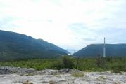
 Perhaps the most famous and one of the most beautiful landscape monuments is Big Yalta, which represents 80 kilometers of the Black Sea coast. The winding shore, approaching close to the sea, as well as the unique main ridge of the Crimean Mountains, plus a dry warm climate, attract many connoisseurs of natural earthly beauty with their landscape.
There are many unique and unusual extreme places Crimea and even Ukraine. Cape Sarych is located on this territory - this is the southernmost point of the country, Alupka is the warmest place in Ukraine, here, according to scientists, there is the largest number of sunny days a year, and Mount Ai-Petri is considered the most windy mountain, there are the most winds. The highest mountain of Crimea is also located here - this is Mount Roman-Kosh.
And not only big Yalta, for long millions of years the entire coast of the Black Sea took on such bizarre shapes, stunning in their beauty in the form of rocky cliffs, pebble and sandy beaches, cozy bays.
The fabulous landscape changes along the entire coast of Crimea, washed first by the Black Sea, then by the Sea of Azov, and then by Lake Sivash. Palm trees, laurels and cypresses, brought to the Crimea much later and giving harmony and beauty Crimean landscape.
The main ridge of the Crimean mountains stretches along the Crimean coast from the southwest to the east, and has a length of about 160 km and a width of 40 - 50 km. The mountains descend like an amphitheater to the sea, forming beautiful "yayla" - this is the Yalta yayla reaching a height of 1406m, where the city of Yalta is located.
Ai-Petri Yayla reaches a height of 1320 m, Alupka and Simeiz are picturesquely spread here. Gurzuf Yayla has a height of 1540 m - Gurzuf is located, Nikitskaya Yayla has a height of 1470 m, here is located, famous far beyond the Crimea, Nikitsky Botanical garden.
Babugan-yayla has the most highest point Crimea 1545m, located on the mountain Roman-kosh. The amphitheaters of these yayls have been inhabited by people since ancient times; ancient human sites have been discovered here.
 Crimean pine
 On the southern side of the Main Ridge of the Crimean Mountains, two belts of vegetation are distinguished: at the top, Scotch pine is more common, and below - at an altitude of 300-400 m above the sea, there are forests of Crimean pine. Then, going down towards the sea, there is the so-called shilyak belt.
Here the vegetation is of the Mediterranean type - high juniper, downy oak, needle, strawberry wood, wild pistachio, etc.
In the forests of the southern coast of Crimea, relic coniferous plants have been preserved - yew berry and high juniper, Juniperus excelsa, individual specimens reach 3-5 meters in volume.
Some copies of these relics reach 1000 years. They can be found in the Laspi tract, on Cape Sarych, Ai-Todor, Martyan, Montedor, in the Kanak gully. Thanks to the relief, in the Crimea you can see a wide variety of landscapes and various vegetation.
3. Landscape of the inner ridge of the Crimean mountains
The northern part, the inner, main ridge of the Crimean mountains descends to Bakhchisarai, and is called the Crimean foothills. Her landscape cut by amazing canyons, mountain ranges and table-like mountain plateaus, as if by nature intended for human settlements. This is evidenced by the ancient cave cities.
The Crimean Mountains were formed over millions of years, rising from the bottom of the ancient sea, where such sedimentary rocks as limestones, sandstones, marls, clays and clay shales accumulated. Rising from the day of the sea, the mountains were exposed to wind, water and different temperatures.
In places of geological faults, under the influence of water, river valleys, canyons and mountain ranges appeared. A characteristic feature of the inner part of the Crimean Mountains is gentle slopes called cuesta (slope). From the dense limestones of the upper layers of the cuesta, ledges-cornices were obtained. In the process of erosion of rocks, the most bizarre figures appeared on the inner ridge: "sphinxes", "mushrooms", "ribs", grottoes, mountains - remnants.
4.Landscapes of the steppe part of Crimea
Landscape The plain part of the Crimea is relatively monotonous, a steppe plain stretches to the north, sometimes there are small hills. In the west is the Tarkankhut peninsula, it is also treeless, and in spring and early summer it is covered with green vegetation and beautiful flowers that fade under the hot Crimean sun by the middle of summer.
The seashore is steep, high, there are caves, grottoes. Moving inland from the Crimean mountains and the sea, you find yourself in the steppe zone, where unusual and fast rivers become calm, large arrays of orchards and vineyards appear, there are large meadows with bright poppies and other vegetation.
The plains gradually decrease from south to north, occupying the northern and central parts. The nature of Crimea is unique in its combination of flat landscapes and mountain ranges. In this part of Crimea, there are many garden and park complexes built after the annexation of Crimea to Russia, natural landscapes are, as it were, decorated and exalted by the landscapes of parks created by human hands. I wrote about one such park complex here.
5. Seas washing Crimea
From the south, Crimea is washed by the Black Sea, and from the east, the Sea of \u200b\u200bAzov is located. Between these two seas is the Kerch Strait, with a width of 5 to 15 km. The depth of the Black Sea in some places reaches 2200 meters and has no noticeable tides or low tides. The depth of the Sea of Azov is about 13.5 meters.
6. Rivers of the Crimean Peninsula
Crimean rivers, as a rule, are not large and full-flowing, they are winding and fast. Most of the rivers, under the scorching rays of the summer sun, almost dry up, or go underground, into karst cavities. The largest Crimean river is Salgir, and the most full-flowing is Belbek.
Crimean rivers, passing through constantly changing mountainous reliefs, canyons and gorges, either falling, or rising, or spreading across the plain, often form whole cascades of waterfalls, attracting numerous groups of tourists.
Crimean rivers are small mountain streams resembling streams. In summer, most often, drying up rivers expose their channel, which is littered with boulders, stones of various sizes and shapes. Sometimes a thin trickle of a stream breaks through these boulders, then hides under the ground and suddenly reappears on the surface of the earth.
But if heavy rain falls in the mountains, the rivers instantly fill with water, overflow their banks, breaking into numerous streams, rapidly rushing down, then uniting into one stream, they capture both large stones and uprooted ones. trees.
Tourists need to know this when choosing a place to stay and place their tourist equipment away from seemingly harmless streams. Crimea is also rich in salt lakes.
7. Caves of the peninsula
 Caves of the Crimean Peninsula
 In Crimea many karst caves have been discovered, which, in their beauty, are attractive to speleologists from all over the world. On Mount Chatyr-Dag, a cave called "Marble" is open and equipped for tourists to visit. This name is given to her because of her unique beauty, reminiscent of the complex pattern of marble.
The cave has several, equipped for visitors, halls and galleries, with a length of about one and a half kilometers. The depth of the cave is 60 meters, and the explored length is more than two kilometers. The unique Marble Cave ranks fifth in the world among the most beautiful caves on the planet.
Well, the longest karst cave Crimea is Red, its length is 16 thousand meters. The record for depth is set by the Soldatskaya Cave, which goes 517 meters deep. Also, one of the unique in Europe for its unusual underground coloring is the Emine-Bair-_Khosar cave, which is located near the Marble Cave.
You can completely organize a visit to many landscape monuments of Crimea on your own, since the infrastructure in Crimea is developed and you can get everywhere by public transport, the roads are not bad.
visit llandscape monuments It can be paid and free, as a rule, visiting the monuments is available from April to October, but there are also winter visits. Many landscape monuments are protected by the state or a great deal of assistance is provided to private individuals who make the Crimean landscape unique, such as .
Categories:/ from 12.02.2013On the relatively small territory of the Crimean peninsula, a variety of mountain and flat landscapes are very clearly expressed (see diagram).
Landscape scheme of Crimea
1 - karst summit surface of Yayla;
2 - mountain slopes of Yaila with a forest landscape;
3 - Mediterranean landscape of skirts;
4 - eastern part of the southern coast (Mediterranean landscape);
5 - southern forest-steppe and forest-shrub landscapes of cuesta ridges;
6 - steppe Crimea, agriculturally developed flat landscape;
7 - Sivash area, dry steppe landscape with fragments of semi-desert;
8 - Tarkhankut Peninsula and Kerch Peninsula, hilly-steppe landscape
Particularly interesting in terms of tourism is the karst landscape of Yail (1) with characteristically developed forms of surface bare karst, with its inherent mines, sometimes serving as roads to penetrate mysterious dungeons, with the usual absence of surface watercourses for karst, with rocky meadows and steppes on high mountain ranges. and with mountain forest, forest-steppe and meadow-steppe vegetation. This karst landscape is widespread on almost all the summit plateaus of the western part of Yayla and on the plateau-like massifs scattered from each other in its eastern part, but it is most strikingly represented on Karabiyail, Chatyrdag and Ai-Petrinsky yayla. Here, between the bare carr surfaces, green meadow grasses are visible only at the bottom of karst basins and funnels on the higher parts of these plateaus, and in low places, the tops of bushes and trees stick out from the mouths of natural mines and funnels. Undoubtedly, this brings exoticism to the landscape of bare rocky territories, makes them spotty.
The lowest tiers of the plateau used to have more forests. Deforestation and the eating of tree shoots by livestock, which impede the regeneration of the forest, in fact, as well as the destruction of grass by very large grazing in the meadows, caused the development of bare karst and a strong spread of bare limestone surfaces, as well as the cause of a failure in the regime of sources under the limestone cliffs bordering the plateau. Of course, in the karst landscape, it is simply necessary to carry out forest-meadow restoration work, which will definitely improve the water regime of the karst sources of the yayla.
The karst summit surface of the Yayla is bordered by the mountain-forest landscape of the slopes of the Yayla (2) with oak and beech forests and mountain-forest brown soils, which is similar in structure to the landscapes of the Carpathians and the Caucasus, and the forests of the Crimean pine growing on the southern slope are unique specifically for the Crimea and have an analogue only in the northern part of the Black Sea coast of the Caucasus. The forests of the Crimean mountains have a very large water protection and anti-erosion role. Very close attention must be paid to their protection and restoration, especially in the areas of mudflow basins. The animals inhabiting the forests of the mountainous Crimea also need protection.
Crimea is characterized by great landscape diversity, which, according to leading experts, is a prerequisite for great biodiversity.
Landscape diversity is a consequence of the unique border location of the peninsula:
- on the border of the temperate and subtropical zones;
- at the junction of the platform and the geosynclinal zone;
- on the border of the ranges of many floras and faunas.
Many features of the landscape structure are associated with its peninsular position - Crimea is almost an island (and in certain geological epochs it was a real island) within the Azov-Black Sea basin, and the latter is a kind of island within Eurasia. The insular position determines some features of the climate, contributed to the emergence of a significant proportion of endemics, and, for some classes of animals, to the depletion of the species composition.
In Crimea, the interaction of mountains and plains plays an important role. Mountainous Crimea is a megaanticlinorium, consisting of two structural floors and a number of large structures. The foothills consist of cuesta ridges located on the raised edge of the Scythian platform. The latter is located at the base of the Plain Crimea. The geological history of the Crimea has more than 200 million years. During this period, various geological structures, loose deposits and landforms were formed. Among the genetic types of relief, erosion-denudation, erosion-accumulative, accumulative (subdivided into marine, lake and river), abrasion, karst, landslide, and in many cases structural landforms are well expressed. The contrast of heights in the Crimea reaches one and a half kilometers, and in the Ai-Petri-Koreiz region, the height difference is 1.2 km at a distance of 3 km.
Morphological relief types are represented by low (undrained and drained) and elevated plains (with subtypes of ridges, wavy, hilly, remnant, plateau-like), foothills, low mountains, and middle mountains. At a lower level, ravine, hollow, beam, valley, basin-like, saddle-shaped are distinguished. The types of slopes are varied: from gentle to steep; open and closed; convex, concave, stepped, straight.
More than two thousand years of economic development of the peninsula has led, along with the destruction of many natural landscapes, to the emergence of various natural and anthropogenic landscapes: agricultural landscapes, residential, recreational, mining and industrial landscapes, as well as natural and technical systems - irrigation, urban, transport and communication, etc.
The soil cover has a variegated spatial pattern, reflecting lithological, orographic, and microclimatic differentiation. Over 400 types of soils and several thousand varieties have been identified in the Crimea.
The habitats of communities of organisms are formed on the basis of landscape systems. Preserving the landscape also means preserving biodiversity. The landscapes located in hard-to-reach territories, due to the terrain conditions, poor transport accessibility, in areas unfavorable for the development of certain types of activity (bad soils, unfavorable living conditions, etc.) have been preserved to the greatest extent. For the Crimea, areas are very typical, occupying small areas, but concentrating within their boundaries a wide variety of habitat conditions, species of organisms and communities. We are talking about contact zones of various geosystems, river valleys, gullies, ravines, steep areas, ecotones, banks of water bodies, places where groundwater exits, prerequisites are created for increasing diversity:
1) ecotone zones, where species diversity increases;
2) hard-to-reach areas where economic activity and tourism have not been widely developed;
3) areas where the conditions for the existence of organisms are improved due to the presence of water sources, additional nutrition, or for other similar reasons.
When describing the landscape structure of the Crimea, experts used the allocation of physical and geographical regions of different levels. The most widespread and recognized system of units: physical-geographical country - landscape zone - physical-geographical province - physical-geographical region - physical-geographical district - physical-geographical region.
Crimea is located within two physical and geographical countries - Eastern European and Crimean-Caucasian. The northern flat part of the Crimea is the Crimean steppe province, which belongs to the dry steppe subzone of the steppe zone. Within its boundaries, four physical and geographical regions are distinguished: the North Crimean lowland steppe, the Tarkhankutskaya elevated plain, the Central Crimean plain steppe and the Kerch hilly-ridged steppe. Within their limits, physiographic regions are distinguished - a total of 12. The mountainous Crimea forms a physiographic province within the Crimean-Caucasian country. It is divided into three physical and geographical regions: the Foothill forest-steppe, the Main mountain-meadow-forest ridge and the South Coast Sub-Mediterranean. Within these regions, 9 physical-geographical regions are distinguished.
The landscape structure of the Crimea is most fully disclosed on the landscape-typological maps of the Crimea (M 1:200,000) and Mountain Crimea (M 1:100,000), compiled by G.E. Grishankov as a result of detailed field work in 1965-1975. and generalizations of extensive empirical material. He used the following mapping units: landscape levels, zones, belts, tiers, groups of localities. Landscape levels are zonal systems formed on a geomorphological basis, relatively uniform in relief and soil moisture, having a planetary distribution. The zonal systems of the Crimea are formed within the hydromorphic, upland, foothill and mid-mountain landscape levels.
The hydromorphic level of Crimea is represented by coastal lowlands - the North Crimean, Sasyk-Sakskaya and fragments on the Kerch Peninsula. The lowlands have a relative height of 0 to 40 m above sea level, are distinguished by exceptional flatness and are represented by one zone - the zone of semi-desert poor forb steppes.
Upland plains stretched from the Tarkhankut Peninsula, through the plains of the Central Crimea and to the watershed plains of the Kerch Peninsula. Their height ranges from 40 to 150 m. They are characterized by a dissected valley-beam and denudation-remnant relief. One zone is expressed - typical poor forb steppes.
The foothill landscape level of Crimea occupies both the northern foothill plains and uplands, and the low mountains of the southern coast of Crimea. The height reaches 600 m, the dissection and mosaicity of the relief and landscape increase. Two natural zones are expressed - foothill forest-steppe and pistachio-oak and oak-juniper forests of the southern coast of Crimea. Features of the climate, soils and vegetation of these zones are determined by the change in the position of individual territories in relation to the mountains and incoming air masses. Differences in soils and vegetation reach the latitudinal-zonal level.
The mid-mountain landscape level in Crimea is represented by the Main Ridge of the Crimean Mountains, which stretches from Balaklava to Stary Krym at an altitude of 400 to 1500 m. Medium-steep and steep slopes predominate in the relief, and on flat tops there are fragments of plains with numerous karst forms. The differentiation of the mid-mountain landscape level into natural zones is based on a change in the position and height of the relief. There are three zones at this level. The most significant differences are observed between the zone of the mountain forest-steppe yail, on the one hand, and the forest zones of the slopes, on the other. The differences between the zones of the middle mountains barely reach the latitudinal-subzonal level.
Specially protected territories have been formed in each region of the peninsula. At the zonal-belt level of the structural organization of biodiversity, the number of protected areas varies depending on the area of the zone and its biocenotic structure, but does not reach international criteria. In general, calculations show that the minimum number of protected areas within the zones of the Plain Crimea should reach 14-26%, foothill - 14-30%, mountain - up to 60%, which is consistent with a number of expert estimates. The natural zones of Crimea are distinguished by patterns of intra-regional organization, which change during the transition from one landscape level to another. On hydromorphic plains, the leading factor of organization is the depth of groundwater. Taking it into account, a hydromorphic zonality is formed, associated with a change in saline groundwater from 0 to 6-8 m. The landscape structure of these plains is determined by a combination of three main hydromorphic belts: undrained, poorly drained and relatively drained belt of plains. In the belt of undrained plains, groundwater (saline sulfate-chloride water) is located at a depth of 0.2-0.5 m, solonchaks and halophytic meadows are widespread here. In the belt of poorly drained plains, the groundwater level (saline chloride-sulfate) ranges from 0.2-0.5 m to 2.5-3.0 m, the vegetation cover is dominated by sagebrush-fescue steppes in combination with halophytic meadows. In the belt of relatively drained plains, groundwater descends to a depth of 3-8 m from the surface, sulfate salinity, the vegetation cover was dominated by depleted variants of feather-grass-fescue real steppes characteristic of upland plains, however, the soil profile retains the features of former hydromorphism. On the upland plains, the leading factors of landscape organization are the relative height, lithology, and the degree and nature of the dissection of the relief. In accordance with the vertical differences in landscapes associated with changes in geomorphological conditions (the degree and nature of dissection, lithology of rocks, the speed and direction of geomorphological processes, etc.), landscape layering is formed. Landscape tiering occurs where a slight fluctuation in altitude above sea level does not affect climate change and, consequently, the structure of the landscape.
In Crimea, three-tiered plains of the Tarkhankut Upland and two-tiered central plains of Crimea are distinguished. The upper tier of the Tarkhankut Upland is represented by structural weakly dissected plains with poorly developed soils of the chernozem type and soddy-grass poor forb steppes. The second tier is located on lower eluvial-denudation plains. It is characterized by thicker soils of the chernozem type and forb steppes. The lower tier of the Tarkhankut Upland is formed by denudation-accumulative hollow-beam plains. These plains are characterized by a relatively variegated soil and vegetation cover, which varies from petrophytic steppes on steep slopes to meadow steppes on gullies.
The landscapes of the Central Crimean plains are represented by a two-tiered structure in the form of real rich herb steppes in combination with savannoid steppes on loess poorly dissected plains and real poor herb steppes in combination with rich herb meadow steppes on accumulative-denudation hollow-beam plains.
Within the piedmont landscape level, the main factors of landscape organization are the position of the piedmont plains in relation to the mountains and the direction of the prevailing winds and the height above sea level, and in some cases the depth of groundwater. Due to the change in relative height, slope microzoning is formed. In Crimea, slope microzoning is well manifested on the plains, in the foothills, and on the southern coast of Crimea. For example, two genetically isolated groups of microzones are well distinguished on the southern coast of Crimea under conditions of low-mountain relief. The lower group includes the bottom of the gullies and the slopes near the gullies, where brown clay-cartilaginous soils are common on the deluvium and proluvium of clay shales and sandstones. The vegetation cover is dominated by shilyakovo-forest complexes.
During historical time, there has been a significant reduction in natural landscapes and a wide development of derivatives formed as a result of the interaction of newly created (constructive) and poorly transformed landscapes. Natural, poorly transformed, landscapes occupy only 2.5% of the territory. These are, first of all, mountain broad-leaved forests, mountain forest-steppe on yayla, solonchaks and halophyte meadows of the Sivash region and the Kerch Peninsula.
Most of the Crimean territory (62%) has been developed for constructive landscapes: arable land, gardens, cities, roads, etc. They require constant addition of additional energy according to a specific plan to maintain their new structure and functioning. This is the broadest type, including residential, water management, recreational and beach, road transport, industrial and municipal, mining and industrial classes. This includes park classes of land, which include the following types: orchards, vineyards, arable land and plantations of tobacco and essential oil plants, nurseries, greenhouses, greenhouses, warehouses, shelterbelts, livestock complexes. Terraced complexes stand out in particular.
The rest of the territory (35.5%) is represented by derived landscapes. Derived complexes are natural complexes reflecting different stages of digression or one of the stages of their denaturalization. They were formed during the spontaneous use of forest landscapes for pastures and during unsystematic felling and fires. This type includes classes of digressive (from polydominant shilyaks to erosional badland) and renaturalized lands (from phryganoid petrophytic steppe to restored forest). At present, in most of the territory of the South Coast, natural forests have been replaced by shrub thickets of the shilyak type, in which shrub forms of downy oak, hornbeam, skumpia, hold-tree, sumac and wild rose dominate.
Destructive lands are negative territorial by-products of human activity. They are the last stage of landscape degradation.
Terrestrial and amphibious landscapes are distinguished in Crimea. The latter include landscapes of rivers, lakes, and coastal areas of the sea, where the functioning of bottom complexes is directly related to surface water layers and sunlight. Zonal-belt conditions (position in the temperate zone on the border with the subtropical zone with insufficient precipitation) determine the dominance of subboreal semiarid landscapes in Crimea. The Crimean mountains disturb the structure of zonal circulation processes: altitude and barrier effects lead to a change in the thermal and water regime within the mountains. Along with subboreal conditions, boreal conditions are formed, in addition to semiarid conditions, semi-humid and humid ones appear.
In Crimea, one zonal type of landscape is found - semiarid steppe, occupying the flat part of the peninsula. Arid (semiarid) conditions are observed in this part of the peninsula: with an evaporation rate of 850-900 mm/year, 400-450 mm/year of precipitation falls. In the Sivash region, the amount of precipitation decreases to 350 mm / year, and the moisture coefficient - to 0.35-0.40. This brings the conditions in this area closer to subboreal arid semi-desert. But the land cover here is more influenced by other factors: the proximity of groundwater and the residual salinity of soils. They lead to the formation here of complexes of wormwood-fescue steppes, halophyte meadows and solonchaks.
In the piedmont and mountainous parts of the peninsula, other types of landscapes are formed, which is associated with the superposition of the zonal background of exposure circulation differentiation (precipitation pre-ascension, an increase in precipitation on the windward slopes and a decrease on the leeward slopes), height above sea level (decrease in temperature with height), meridional sector, positions in relation to the sea. Geographically, these factors are manifested within tens of kilometers. Mountains disturb the structure of meteorological fields, as a result of which the amount of precipitation increases by 1.5-3 times, and spatial differentiation of the thermal regime occurs. Therefore, in different parts of the mountains and foothills, conditions of heat supply and moisture supply were formed, close to subboreal-semi-humid forest-steppe (central and eastern parts of the Foothills), subboreal humid forest (the Northern macroslope of the Main Range and the upper part of the Southern macroslope - up to about 800 m), subboreal southern humid forest (the lower forest part of the Southern macroslope of the Main Ridge - at an altitude of 400-800 m), subboreal "southern semi-humid forest-steppe (southwestern foothills - the region of Sevastopol, Bakhchisaray, the Baydarskaya valley and the southeastern part of the south coast, with the exception of the most arid coastal part - see below), subboreal southern semiarid steppe (region of Meganom, "Koktebel, Ordzhonikidze). In the extreme south-west of the peninsula in the coastal zone; (up to a height of about 300 m) heat supply conditions approach subtropical (Miskhor: sum of temperatures above 10 degrees is about 4000, the temperature of the coldest month reaches t 4.5 degrees). From west to east, the amount of precipitation decreases, and their maximum shifts to summer, which reduces their effectiveness and brings conditions closer to semi-arid ones (east of Alushta to Sudak and Karadag).
Humid boreal and boreal-subboreal conditions prevail at altitudes of 900-1000 m and more. According to the conditions of heat supply, three groups, or series, of landscapes were distinguished: boreal, boreal-subboreal and subboreal. Subboreal can be divided into subgroups - typical and southern. Within the subboreal southern forest-steppe group, a sub-Mediterranean variety is distinguished. According to the moisture conditions, semiarid, semihumid and humid series are distinguished.
Thus, based on the analysis of the position on the scales of heat supply (the sum of temperatures is more than 10 degrees) and moisture supply (the Vysotsky-Ivanov humidification coefficient), it was revealed that in Crimea there are prerequisites for distinguishing 8 zonal (levels 1 and 2) types of landscapes: boreal, boreal- subboreal, three subboreal, three subboreal southern.
Within the typical steppe landscapes in the Plain Crimea, in the Sivash region, semi-desert steppes and halophyte meadows are common. Their appearance is associated not so much with the deterioration of moisture conditions (which goes in a northeasterly direction), but with the influence of saline soils and groundwater, that is, with factors of an edaphic and hydrogeological nature.
On the Yailas, the climatic conditions correspond to boreal (taiga) and boreal-subboreal (subtaiga) landscapes, however, hydrological-lithological and geomorphological conditions lead to a sharp decrease in the amount of moisture that can be used by plants, resulting in the formation of meadow steppe and forest steppe. The growth of tree species is also hindered by severe microclimatic conditions: high wind speeds in winter with high air humidity. Landscapes are also affected by evolutionary factors related to the laws of self-development of landscape components. After the removal of the anthropogenic pressure, succession shifts begin, ending with the formation of communities in one way or another close to the original ones. Since anthropogenic impacts have been manifested over the past millennia (and especially centuries), a patchwork system of plant communities has emerged on the territory of the peninsula from different stages of successional series of vegetation types.
Many factors differentiate landscapes within local territories. River erosion leads to the formation of valleys, meso- and microscale slopes of different steepness and exposure. The formation of slopes is influenced by many other factors. Slope differentiation contributes to uneven inflow of solar radiation due to different steepness and exposure, redistribution of solid (snow) and liquid precipitation that has fallen on the surface. There are effects of shielding solar radiation by ridges, reducing the flow of radiation to the bottoms of river valleys. All this creates a significant territorial differentiation in the moistening of landscape complexes at a very short distance, often within hundreds and even tens of meters, a sharp change in temperature conditions and soil moisture is observed. This causes a change in the nature of soil-forming processes, the formation of loose surface deposits, the migration of chemical elements and the formation of the geochemical environment as a whole.
Particularly noticeable territorial changes occurred within the foothills, since here the steppe complexes are replaced by forest ones (that is, the landscape system has the character of an ecotone), and any differentiation of conditions within the ecotone causes a rather sharp change in complexes. Change of landscape complexes often occurs within short distances.
According to hypsometric properties, classes and subclasses of landscapes are distinguished. There are three classes of landscapes in the Crimea: plains, foothills and mountains. They are divided into subclasses. Plain landscapes are divided into low-lying (Sivash) and elevated (Tarkhankut Peninsula, Central Crimean Plain, Kerch Peninsula). The class of foothill landscapes is divided into cuesto monoclinal and inter-ridge. The class of mountain landscapes in the Crimea is represented by two subclasses - low-mountain (the main part of the mountains) and medium-mountain (yayly and the highest ridges). Within the low-mountain subclass, a mountain-seaside variety (south-coastal regions) can be distinguished.
By positional properties, groups, subgroups, families, subfamilies, categories and varieties of landscapes are distinguished.
A semi-desert variety of semiarid steppe landscapes occupies the Sivash region. This is a low-lying plain, gradually rising from the coast of Sivash and the Karkinitsky Gulf of the Black Sea to 40 meters. It is composed of eolian-deluvial loams and clays. The valleys of rivers and beams are filled with alluvial loams and sandy loams, firth sands and clays. Within the territory, climatic and geomorphological differences are weakly expressed, the main role in the differentiation of landscape conditions is the depth of groundwater. Directly at coastline, in the lower reaches of the rivers, groundwater is located a few tens of centimeters from the surface. Therefore, solonchaks and halophyte meadows predominate here. Along the coast, wetlands with thickets of reeds and other hydrophytes have formed, serving as a habitat for numerous birds. The higher areas are dominated by sagebrush-fescue steppes. Even higher they are replaced by feather grass-fescue steppes.
The flora and fauna of these landscape areas have been preserved in small areas, since 50-70% are arable land and 20-30% are pastures with a strong manifestation of pasture digression. Here you can observe the processes of desertification. At the same time, the widespread development of irrigation (about 30% of the area of the Svash region) led over the last few decades of the 20th century to the formation of landscape complexes of the humid type. During the irrigation process, many areas were flooded. Most of the territory is occupied by agro-ecosystems. Of greatest interest from the point of view of biodiversity conservation are sites in the central part of the Sivash region, which serve as a temporary habitat for migratory birds. For wetlands formed as a result of desalination of the Sivash with waste water, local bird species are also characteristic.
The greatest problems for the biological and landscape diversity of this zone are the change in the hydrological and hydrogeological regime under irrigation, the deterioration of the quality of surface and underground water due to the use of fertilizers and pesticides. Until the early 90s of the 20th century, the area of natural biocenoses was decreasing due to an increase in the area of arable land, however, in recent years, the reverse process of abandoning agricultural land has begun, accompanied by the formation of ruderal and segetal vegetation and weed biocenoses on them. Chemical pollution is largely associated with rice cultivation. There is a task of gradually replacing rice cultivation with other types of land use. However, it would be wrong to simply stop rice cultivation by abandoning these areas. In this case, weedy phytocenoses will inevitably form on these lands and the process of strong secondary salinization will begin.
Subboreal steppe typical landscapes are the only zonal first-level landscape type in Crimea, which occupies approximately 60% of the peninsula, stretching from the Tarkhankutsky to the Kerch Peninsula and occupying the entire flat part of Crimea, with the exception of the Sivash region. The natural vegetation of these landscapes has been preserved in small areas. It has been replaced by fields, orchards, vineyards, pastures and is characterized by a very depleted species composition. This territory is more dissected compared to the Sivash region - elevated plains dominate here. Irrigation of fields led to the formation of complexes that differ significantly from zonal ones.
Within this zone, experts distinguish three landscape areas, characterized by a different set of landscape areas and tracts:
- 1. Tarkhankutskaya elevated plain, composed of limestones, red-brown clays, loess-like loams. Ridge uplands are combined on the peninsula with deeply incised valleys (dry rivers). The area is characterized by hot dry summers and relatively warm winters without a clearly defined period with negative air temperatures. Humidification is insufficient - evaporation is approximately twice the amount of precipitation. The territory corresponds to the subboreal semiarid steppe type of landscape. Almost no original vegetation has been preserved. Arable land covers approximately 50% of the territory. Cereals predominate among agricultural crops. Quite significant areas (about a third of the territory) are occupied by pastures represented by poor-forb steppes, often their petrophytic variants.
- 2. The Central Crimean territory is composed of brown continental clays and loess-like loams, covered in many places with layers of anthropogenic proluvial-deluvial deposits. The wavy-hollow relief prevails with elevations from 50 to 120 m. The climate differs from the Tarkhankut Upland by a slightly higher amount of precipitation: up to 500-550 mm per year and somewhat more severe winters. The territory is dominated by flat-hollow, valley-beam, flat-plain, valley-dry river and coastal-halogen areas. This is the most plowed area - 75% (the predominance of grain crops, part of the land is occupied by vineyards and orchards, industrial crops). Natural steppe areas have been preserved in small patches.
The largest number of habitats is observed in the river valleys. Here are the most contrasting conditions in terms of moisture, geomorphology, and lithology. At the same time, most of the settlements are confined to the river valleys, that is, in the valleys there is a peculiar neighborhood of small natural and contrasting landscape complexes and settlements.
3. The Kerch zone occupies the Kerch Peninsula. There are two main parts of the peninsula: the southwestern part, carved with heavy saline Maikop clays, and the northeastern part, composed of clays, sands, marls and limestones. Arable land occupies 35% of the peninsula. The southwestern part is dominated by desert steppes, halophyte meadows, and typical poor forb-grass steppes. The northeastern part is dominated by petrophytic shrub-forb-cereal steppes in the remnant-watershed areas, feather-grass-fescue steppes on sloping plains, fescue-wormwood-desert steppes in basins. These territories are mostly used for pastures and are in different stages of pasture digression.
Special ecotopes are formed in the coastal parts of the zone of typical steppe landscapes. Here, in many areas, abrasion processes have led to the formation of dissected steep banks treated with water erosion. The large dissection determined the poor suitability of the sites for economic use, which contributed to the conservation of plant and animal species and biocenoses here. The contrast of the relief, and thus the microclimatic conditions, favors the survival of animals in conditions of fluctuating weather and changing seasons. In many parts of the coast of the peninsula, high biodiversity has been preserved (the extreme western part of the coast of the Tarkhankut Peninsula - the areas of Dzhangul, Atlesh; sections of the Azov and Black Sea coasts of the Kerch Peninsula - areas of Karalar, Osovina, Opuk).
Subboreal forest-steppe typical landscapes are zonal landscapes of the second level; they occupy the Foothills. Here there is a change of flat landscapes by mountainous ones. The territory is crossed by the Outer and Inner cuesta ridges, separated by an inter-ridge depression. The ridges are composed of limestones, marls and clays, the depression between the ridges is composed of marls. The climate of the territory becomes more humid and cool compared to the steppe part: the amount of precipitation here increases to 550-650 mm/year, and the moisture coefficient - up to 0.55. It is distinguished by a more significant territorial differentiation of landscapes, since here a dissected relief is observed, there is a sharp change in meteorological fields due to the transition from the flat to the mountainous part.
Large differences develop between the northern and southern slopes of the cuestas due to the different amounts of incoming solar radiation. But in many cases, it is the southern steep slopes of the cuestas that are wooded, while the northern gentle slopes are usually plowed up. This is due to the practical impossibility of using the steep southern slopes for agricultural activities. The treeless slopes were previously used for grazing, while the forested slopes have retained a relatively natural appearance. In the 1960s and 1980s, terracing and planting of pines were carried out on many treeless southern slopes of the cuestas, which had very different consequences for landscape and biological diversity in different areas. The steep slopes of the cuestas have the greatest number of location types and habitats. This area has changed significantly. This is the most urbanized part of the peninsula with many transport arteries. There are quite a few quarries for the development of building materials.
Subboreal typical forest zonal landscapes of the second level occupy the main part of the Northern macroslope of the Crimean Mountains. Forest landscapes in this area have received the most vivid manifestation and are best preserved. The following factors are of primary importance for the formation of the diversity of ecotopes here:
Altitude above sea level (height difference is 500-600 m). Here, the altitudinal zonality is quite well (better than in other regions of the peninsula) manifested: fluffy oak forests - rocky oak forests - hornbeam and beech forests;
Exposure differences: between the slopes of the northern and southern exposures, there are very significant differences in the amount of solar radiation (up to 50-60%);
Effects of closed slopes.
This is the most forested part of the peninsula. Along with relatively favorable climatic conditions, this was favored by the poor accessibility of many areas for humans (for example, the Central Crimean Basin). Settlements and agricultural lands occupy only narrow bands of the bottoms of river valleys.
Yayly - according to the background climatic conditions, they correspond to boreal and boreal-subboreal: the amount of precipitation is 600-1500 mm / year, the temperature of the coldest month is from -2 to -5 ° C, the temperature of the warmest month is from 12-13 to 16-17 °C. The evaporation rate varies within 500-700 mm/year, the background climatic humidification is normal or excessive. Yayla landscapes have a pronounced azonal character associated with lithological and geomorphological conditions. Falling atmospheric precipitation falls through cracks and moves through underground cavities to the flysch aquiclude, unloading on the slopes of the yail. Differentiation of ecotopes is associated with lithological differences (limestones have different degrees of fracture and susceptibility to karst manifestations), the existence of a large number of sinkholes. The steppe and forest-steppe landscapes of the Yail form a kind of island among the surrounding forest landscapes, which determines their well-known isolation and contributes to the formation of endemic species of organisms.
The woodlands on the southern steep slopes of the yayles are azonal communities. The latter are associated with lithomorphic and geomorphological factors. Falling atmospheric precipitation is poorly retained in place due to the high steepness of the surface, slope processes are strongly manifested: rockfalls, scree, washout of soil and loose deposits. These are very unstable landscapes. No anthropogenic loading is recommended here.
Subboreal forest southern landscapes occupy the lower part of the Southern macroslope of mountains - from 800 m to 400 m. They are characterized by a significant participation of pine forests. Within this zone, a rather high percentage is occupied by sloping and steep slopes, which determines the intensification of erosion processes, a significant manifestation of rockfalls, screes. On gentle slopes, more favorable forest conditions are formed. The territory is located in close proximity to the settlements of the South Coast, to recreational complexes. It is pierced by numerous hiking trails, despite the conservation regime of many sections. Therefore, it is subject to a rather significant anthropogenic impact. Especially dangerous for these fires associated with tourists. Subboreal forest-steppe southern landscapes occupy the southwestern Foothills (the region of Sevastopol, the lower part of the basins of the Belbek and Kacha rivers), the entire southeastern part of the South Coast (from Alushty to Karadag, with the exception of Meganom and Kiik-Atlama. This zone is characterized by large territorial contrasts associated with a variety of relief, rocks.Mild winters are of great importance - the temperature during the cold period does not fall below 20 ° C here, and the average January temperature is 2-3.5 ° C. Due to mild winters, the proportion of winter-green plants in these areas increases .
The Mediterranean variant of subboreal typical southern forest-steppe landscapes roughly corresponds to the sub-Mediterranean type of landscape.
The landscapes of the region of the western part of the South Coast are already of the forest-steppe type - subboreal southern forest-steppe, but they have a more pronounced heat supply (the sum of temperatures is above 10 °), a well-defined winter maximum of precipitation, evapotranspiration 900-950 mm / year, annual precipitation 450-650 mm . The coefficient of moisture is 0.5-0.7, which corresponds to the forest-steppe. The heat supply does not reach the sum of temperatures of 4600, which is characteristic of the lower boundary of the subtropical climate. Therefore, this region is a special variant of the subboreal southern forest-steppe landscapes. These landscapes are characterized by the presence of a relatively large number of evergreen species. This area has undergone a major transformation. There are quite a lot of parks with introducers, part of the territory is occupied by vineyards. On the other part, natural communities have been preserved, but they have been greatly transformed. The dissection of the relief is very large, which determines the presence of a large number of habitat types associated with the bottoms of river valleys (with steeply dipping channels), slopes of different steepness and exposure. Transformations are associated with the construction of roads, cities, water pipelines. Landslides became more active, groundwater flows were restructured, which led to large changes in soil moisture, to the formation of new plant communities. The latter adapt to large recreational loads, which is reflected in the species composition.
Subboreal semiarid southern landscapes are distributed in small areas in the area of Meganom, Kiik-Atlamy in the southeastern Crimea. They are characterized by increased evaporation rates - up to 1000 mm/year and more, a decrease in the annual amount of precipitation to 350 mm. The landscape complexes of the seaside strip of the mountainous part of the Crimea are formed in connection with the salt effect of the sea and the special nature of the microclimate, the great role of abrasion processes. The greatest contrast of landscape conditions here is manifested within a narrow coastal zone.
The landscapes of the river valleys of the mountainous part are a specific type of landscape that is formed in the eternal valleys. Its specificity is related to the following factors:
1) location below other landscape complexes, which leads to the transfer of additional water here; the formation here of accumulative deposits - alluvial, proluvial;
2) watercourses reshape the bottoms and slopes of valleys, which leads to constant restructuring of landscapes;
3) in the Crimea, where moisture is the main limiting environmental factor, river valleys have more favorable conditions for plant growth;
4) landscape complexes of valleys have a very small width and a large length, the small width of the complexes determines the territorial proximity of landscape complexes, the ability for animals to migrate from one landscape to another, depending on the need.
Ecotones are boundary systems, which are transitional zones between neighboring landscape systems, characterized as stress bands with maximum gradients of changes in the parameters of landscape systems. When analyzing biodiversity, it turns out that it is in ecotones that its value is most often the largest. In addition, ecotone landscape systems are characterized by specific properties, a more complex and diverse territorial structure, which creates conditions for the formation of more diverse and favorable habitats for biota than in neighboring landscape systems. Ecotones are more dynamic always more unstable in space-time. It is ecotone systems that are the first to react to changes in external conditions and therefore are indicators of changes in the ecological state of bordering landscape systems. They act as a kind of buffers on the way of natural and economic impacts. Ecotones often play the role of refugia.
Crimea can be considered as a complex ecotone. The peninsula is located at the junction of the temperate and subtropical zones and is a climatic ecotone. The proximity of land and sea for kilometers led to the formation of a variety of aquatic-territorial landscape zones of the coast.
There are four aquatic-territorial landscape macroecotones: South Coast (from Cape Aya in the south to Cape Ilya in the northeast); Kalamitsko-Karkinitsky (from Sevastopol to Karkinitsky Bay); Kerch (covers the coast of the Kerch Peninsula); Sivashsky. Similar in origin (at the contact of contrasting land-water media), they are very different in terms of landscape.
The landscape diversity of the South Coast ecotone is the greatest (up to a height of 350-400 m above sea level), in which 9 types of landscape areas are distinguished. The Sivash ecotone is interesting in that several factors are involved in its formation at once: the influence of the sea, a change in the degree of halohydromorphism, and the climatic factor. Moreover, the action and superposition of factors occur as if in one direction, which affects the formation of a significant width of the ecotone (from 10 km in the area of the Arabat Spit to 30 km). The landscape diversity of the ecotone is quite large, although less than that of the South Coast. It distinguishes 7 types of landscape areas. The Kalamitsko-Karkinitsky landscape ecotone is a coastal strip 4-6 km wide, including a system of shallow salt lakes. It is characterized by the least landscape diversity. Within this ecotone, 5 types of landscape areas are distinguished. The Kerch ecotone is formed by the interaction of different tectonic structures of the Crimean mountains and the Crimean plains, which formed the macroecotone of the foothills. The entire Mountainous Crimea is a phytoecotone that formed on the border between the Circumboreal and Mediterranean floristic regions and concentrated most of the phytodiversity of Crimea - 92.7%. These ecotones are associated with the boundaries of the physical-geographic regions of the Crimea, landscape levels and belts. Under anthropogenic influence divergent ecotones are formed, in which the abundance of species and individuals decreases in comparison with the bordering natural community.
A special situation is developing in the Plain Crimea. Here, the degree of anthropogenic transformation of the landscape structure is the highest, and the territory is almost a continuous agricultural landscape. Suffice it to say that the percentage of plowing of land exceeds 80%, and there are practically no forests and protected areas. In such conditions, areas with preserved natural vegetation (as well as forest belts) themselves become ecotones between different land uses.
Literature
- 1. Biological and landscape diversity of the Crimea: problems and prospects. Simferopol: Sonat, 1999. - 180 p.
- 2. Podgorodetsky P.D. Crimea: Nature. - Simferopol: Tavria, 1988.