Ascension Island: history of discovery, location and territorial affiliation. O.ascension Ascension Island on the map of Africa
Ascension Island - volcanic island, located in the Atlantic Ocean, 1600 km west of the African coast. It is part of the British Overseas Territory of Saint Helena, from which it is located 1287 kilometers to the north-west. Main city and the port is Georgetown.
The island was discovered by the Portuguese Juan de Nova in 1501, but he did not make any descriptions of the island. In 1503, on Ascension Day, the island was rediscovered by the navigator Alfonso d "Albuquerque, who gave the island the name in honor of the Ascension of the Lord, which he still bears. Being dry and barren, he was of little interest to the sailors of the East India Fleet. The island remained uninhabited until 1815, when a small British garrison was stationed there.After the death of Napoleon in 1821, the island became a base for supplying ships that prevented the slave trade on the West African coast.From 1922 to 1964, the Eastern Telegraph company managed the island, and from 1964 in connection with the deployment The BBC station decided to appoint an administrator.
During World War II, the United States Government, in accordance with an agreement with His Majesty's Government, built the Widewake airstrip. From 1943-45 over 25,000 American aircraft transited cargo destined for the North African, Middle Eastern and European theaters of war. In 1957 the US presence was re-established and the airborne landing site was enlarged and is now also the USAF Southeast Tracking Station. A NASA tracking station was built in 1967 but has since been closed. There is a weekly USAF air service between Ascension Island, Antigua and Air Force Base Florida. Ascension Island is still a stopover for British flights between the UK and Falkland Islands. So in 1982, during the Falklands conflict with refueling on Ascension Island, British Nimrod patrol aircraft made several flights into the conflict zone, which became a new record for long-range reconnaissance operations by the British Air Force.
The island has one of the five antennas used in the operation of the GPS satellite navigation system. The other four are located in Kwajalein Atoll, Diego Garcia, Colorado Springs and Hawaii. There is no local population as such on the island. The inhabitants of the island are mainly employees and the military with their families. The population in 2005 was 1,100 people, mostly residents of Saint Helena, as well as 150 residents of the United States and 200 people from the United Kingdom.
A housewife in the United States, as always by chance, finds an island with the help of a satellite. And on this island, suddenly sees large group incomprehensible structures in the form of Tesla towers. The secret of this island has not yet been revealed.
A bit of history. Being engaged in the study of medicinal water, I found such a person as Valery Kondratov on the net. He, dealing with the secrets of Hitler's flying saucers, studied the work of Viktor Schauberger. Then, suddenly, he began to study runes. And then, suddenly flew on a trip to various places in the Atlantic. And so, during his flight in an airplane, he sees something in the ocean that interested him. And then a new metamorphosis. Kondratov begins to study the bottom of the ocean. First the Atlantic, and then all the other oceans on Earth. There, in the ocean, Kondratov finds many scientific radio towers. Which lead him to the secret HAARP science program. What is this program in the USA? This is a program about how to use waves to control the climate and the masses of people anywhere on earth. Let's tell ourselves frankly that we live in a society dominated by the principle of the Animal Mind (Cunning and Cunning, Aggression and Strength). People call it "Divide and Conquer". Literally in parallel with Kondratov, a certain Ridgen (Teacher from the East) appears in Kyiv. He creates a society called AlatRA. A few years later, this society writes a report called Primordial Physics AlatRA. In this book, a new concept of physics is introduced - the activity of the impact of the general Septon field on the human community. What is it? It is this AlatRA physics that explains why we need Nikola Tesla's towers. And at the same time, the mistake that Tesla made. The fact is that this Septon field can control human consciousness! If earlier the Atlanteans knew about this field, now the modern heirs of the Anunaki (or simply Power) can introduce mental attitudes for the younger generations of the human race, beneficial to the authorities (remember the TV and a magician like Kashpirovsky). And if any power is not yet polesized to Service to Others and it still has only the Animal nature (Service to Self), then it tries to manipulate scientific discoveries to increase fear, hatred and servility. Ancient spiritual traditions said. That true spiritual knowledge makes people free, independent of the illusions of the material world, reveals the inner spiritual strength.
 However, when religions began to form in human society as institutions of priestly power, power-hungry priests began to remake this knowledge into a convenient form for manipulating people. Recently Valery Kondratov was on an excursion in Egypt. And what did he see there? A whole group of temples, which had one purpose to control the people of Egypt with the help of a septon field (with elements of sound). Today, looking at pictures of Tesla towers on the islands in the Atlantic Ocean, we can see how the impact on people's consciousness occurs. Let me remind you once again, in order to understand the purpose of many Tesla devices and their new varieties, you need to understand the information about the origin and structure of elementary particles, about the fundamental principles that make up matter, about the relationship between elementary particles and cosmology in the light of the unified field theory, about electromagnetic and gravitational interactions, about alternative energy sources.
  Valery Kondratov begins to notice amazing things in the ocean. For example, the presence of a wall in the ocean. What does it mean? And this wall goes across the Atlantic! Kondratov continues to study the bottom of the ocean and finds more and more signs of the presence of intelligent beings in the ocean. By posting the resulting photos on the network. He has already moved to Bermuda Triangle and south to Africa. And at this time, a woman from the USA appears. Here is what they write about her online. Researcher "Reverend Michelle Hopkins" (a pseudonym) made a surprising discovery. In the southern part Atlantic Ocean she discovered a point from which powerful radiation emanates.
  Having established the coordinates, she first discovered an unnamed island, about which nothing is known, and then another, where, most likely, the base of the US naval forces is located. Lost in the ocean, the island has modern infrastructure, an airport, many buildings, including a residential area, storage facilities for oil products, and most importantly, buildings with recognizable installations, very similar to those known in the HAARP system, and are the development of Nikola Tesla's technologies. . According to the direction of the radiation waves, the author of the find suggests that the activity of these installations could be the cause of 2 recent earthquakes. It is also possible that the purpose of the radiation installations on this strange island is to cause massive earthquakes in the Mid-Atlantic Ridge in order to provoke a giant tsunami that can strike both south and north of everything. east coast America? At least the area of action of the waves indicates such a possibility. Do you know what is strange and secret about this, the truth, like everything connected with the Cosmos? First, the real name of this lady is unknown. At first, just a movie appears on the net. Like I saw something interesting. 1 year passes. It is not known who is investing in the project for the development of this information. And already the film crew begins to somehow explore this island in the ocean.


A new more scientific film about this appears in the USA and on the web. mysterious island. Now someone is shooting in different frequency ranges. And we are all in shock! Rays thousands of kilometers long emanate from the island towards the United States.
 It is strange that this topic deserves so little attention, because the first 2 minutes of the video is enough to understand that no military base or radar station can produce radiation of this magnitude, excuse me, but there is a coverage area of half the Atlantic Ocean. With a high probability, it can be assumed that, most likely, some kind of hidden, secret object Whose he is and why is hard to understand. If something produces such a signal, then obviously not those round buildings or any others on the surface of the island. The name of the island also attracts attention, of course, that it was called that for a long time, but the word Ascension carries a lot of information for knowing person. Yeah! Sensation. An island unknown to mankind. Ascension Island. During World War II, the US Government, in accordance with an agreement with His Majesty's Government, built the Widewake airstrip on the island. In 1943-45, more than 25,000 American aircraft were transiting cargo destined for the North African, Middle Eastern and European theaters of war. In 1957, the American presence was re-established and the airborne landing site was enlarged and is now also the US Air Force Southeast Tracking Station. A NASA tracking station was built in 1967 but has since been closed. There is a weekly USAF air service between Ascension Island, Antigua and Air Force Base Florida. Ascension Island is still a stopover for British flights between the UK and the Falkland Islands. So in 1982, during the Falklands conflict with refueling on Ascension Island, British Nimrod patrol aircraft made several flights to the conflict zone, which became a new record for long-range reconnaissance operations of the British Air Force.

The island houses one of the five antennas used in the operation of the GPS satellite navigation system. The other four are located in Kwajalein Atoll, Diego Garcia, Colorado Springs and Hawaii. In the light of current knowledge, I can assume that experiments are being carried out in the United States to manage new secret fields for the time being. And while we are told on the news that two planes can shoot down 3 buildings in New York, the secret of this island will remain for you and me.

There are no related posts.
Ascension Island is not a favorite tourist destination. It would be more correct to say that tourists on this small piece of land are a rarity. Even lovers of "wild" recreation do not come here, they do not favor expensive hotels and crowded beaches. To many, this will seem strange, because geographical location the islands are very interesting. But the nature of the island is simple and unpretentious, there is simply no riot of colors and exotic plants here. The tourist infrastructure is not developed. So what are tourists to do there? And anyway, what do we know about this place?
Location of the island
Ascension Island is volcanic. Location - south of the Atlantic Ocean. On the maps you can see that it is located about halfway from South America to Africa. From Ascension Island to the West African coast - about 1600 km.
The area of the island is not large at all, it is about 91 km2. Coastline without strong breaks, but with a large number of small bays and bays. There are many shoals along the coast.
A story that began with the opening
What is interesting about Ascension Island? The history of its discovery began in 1501. It was then that the Portuguese Juan da Nova discovered on his way unknown land. The traveler sailed to India and did not want to waste time on research. The only thing he did was to display his find in the ship's logbook.

In 1503, an uninhabited island was in the way of another Portuguese, Alphonse d "Albuquerque. The "rediscoverer" turned out to be more curious. He landed on a new island, examined its territory and gave the name in honor of the Christian Lord.
For several centuries after its discovery, Ascension Island remained officially uninhabited. Pirates sometimes came here to replenish fresh water supplies. By the way, the source was found by the robbers, who crashed near the island. It was the ship of the famous British pirate William Dampier.
Settlement of the island
Permanent residents on the island appeared in 1815. During this period, Great Britain decided to equip Ascension Island with a small military outpost. It was assumed that the garrison would be very small, but even with it there were financial problems. There was simply no money in the corresponding budget item. Then the British went to the trick. In documents, they began to refer to the island as "HMS Ascension", and funding for the garrison flowed from another budget item.
In 1821, the military base on Ascension Island was expanded, British ships began to enter here. In addition, patrol ships replenished supplies here, which prevented the slave traders from delivering “human goods”.

In the last century, a space observation base was placed on the territory of Ascension Island. To date, the staff of this base is the population of the island. The average number, according to data from a decade ago, is slightly more than 1,000 people who serve one of the antennas of the satellite navigation system.
Territorial affiliation
In fact, Ascension Island is part of This term appeared in 2002 and replaced the term "British Dependent Territories". This overseas territory unites Ascension and the Tristan da Cunha archipelago. Education is subject to the authority of the British Crown, but has self-government and broad autonomy.
The administrative center of the overseas territory is located on the island of Saint Helena. The autonomy is so wide that each member of the formation has its own emblems and flags. Ascension Island and nearby territories (Saint Helena and Tristan da Cunha) are not officially part of the UK. However, this country is their main economic partner. And the development of education is entirely due to the resourcefulness of the British government. All Overseas Territories symbols are endorsed and approved by the British Crown.
Description: coat of arms of Ascension Island, flag
Until 2012, Ascension Island used the symbols of the United Kingdom when necessary. Although one part of this formation, namely the island of St. Helena, the flag and coat of arms appeared in 1984. Tristan da Cunha had an official coat of arms in 2002.

Since 2012, the flag of Ascension Island has been considered a blue panel, at the flagstaff of which is depicted. In the opposite corner is the coat of arms of Ascension Island. It is an image of one of the attractions of the island - Green Mountain. On the sides are depicted two green turtles holding a shield with images of three albatrosses against the background of the ocean and sky. The design of the coat of arms was developed taking into account the wishes of the inhabitants of the island. In honor of the approval of the flag and coat of arms, the Mint of Great Britain minted a commemorative coin "The New Coat of Arms of Ascension Island".
Note to the tourist: climate and nature
In spite of military base and the lack of tourist infrastructure, guests of the island will find something to see. The main attraction is the space tracking station. Small ones are allowed in here. tourist groups by special order. The rest of the guests admire the majestic antennas from afar. There is a small military museum on the island, worthy of attention tourists.
Guests reach the island by plane once a week and by Royal Mail ship once a month. The main flow of tourists - private yachts, calling to replenish supplies.

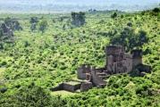
On the island, you can climb to the highest point - Green Mountain. Here, despite the volcanic rocks, flowers and ferns have grown. Many of the plants and insects are found only in this part of the world, which may be of interest to connoisseurs. The coast is inhabited by large sea green turtles and birds.
» ascension island
Ascension Island is a lone island in the Atlantic just south of the equator, about halfway between Africa and South America. Most of it is black and red volcanic deserts, very similar to, which, together with almost year-round 25 ° -35 ° C and white sandy beaches, breaks all possible patterns.
This island is an unsinkable aircraft carrier of the Anglo-Saxon military, there are military bases of the British and Americans, from here the BBC slanders on long waves, Cable & Wireless transmits secret signals, the Apollo mission was monitored here and the French Ariane is being monitored. Getting here is not a trivial matter, but it is the most beautiful and interesting tropical island from what I have seen
The entire population of the island consists of 900 British and American military and signalmen, their families and service personnel from among the inhabitants, who are here 2 days by sea 
This image is in the public domain because it contains materials that originally came from the United States Central Intelligence Agency’s World Factbook
The last eruption here was about 500 years ago, and a noticeable part of the small territory of the island is still quite fresh. 
Comfortless Bay
On Ascension, everything, including idyllic tropical bathing, takes place against the backdrop of beautiful antennas. Do not like antennas, but love palm trees and coconuts? You are a miserable citizen! 
Antennas of the BBC Atlantlic Relay Station at English Bay
Since the discovery by the Portuguese in 1503, this deserted island was hardly used until the British established a military base here in 1815 for protection;
in 1898, British signalmen first appeared on the island: the Eastern Telegraph Company (now Cable and Wireless) runs a telegraph cable from the United Kingdom to South Africa through the island;
during the Second World War, the Americans build an air base here;
in the 1960s, the BBC and NASA settled here;
in 1982 they fought with Argentina for the Falklands from here;
in the 1990s, the European Space Agency, in connection with the Ariane 5 rocket program, builds a ground station here
tourism is allowed in 2002!!!11 
The moon looks almost down, and not sideways, because it is almost the equator
With such a history, it's no surprise that the main eye candy on this island is the beautiful antennas. 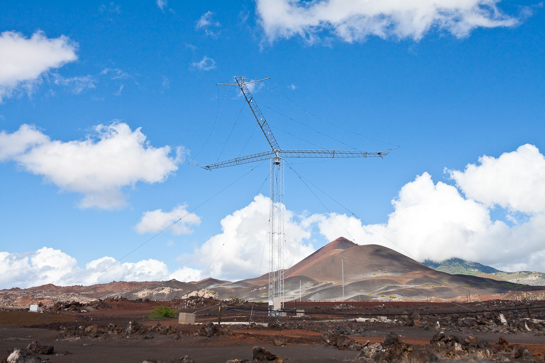
Communications Day! 


This, as they say here, "Mexican thorn" Prosopis juliflora(mesquite tree, a type of mimosa), is a dangerous alien from the seventies: it reproduces with terrible force through donkey shit. What is its danger for the volcanic desert, I did not understand: before the appearance of this mimosa, nothing grew here 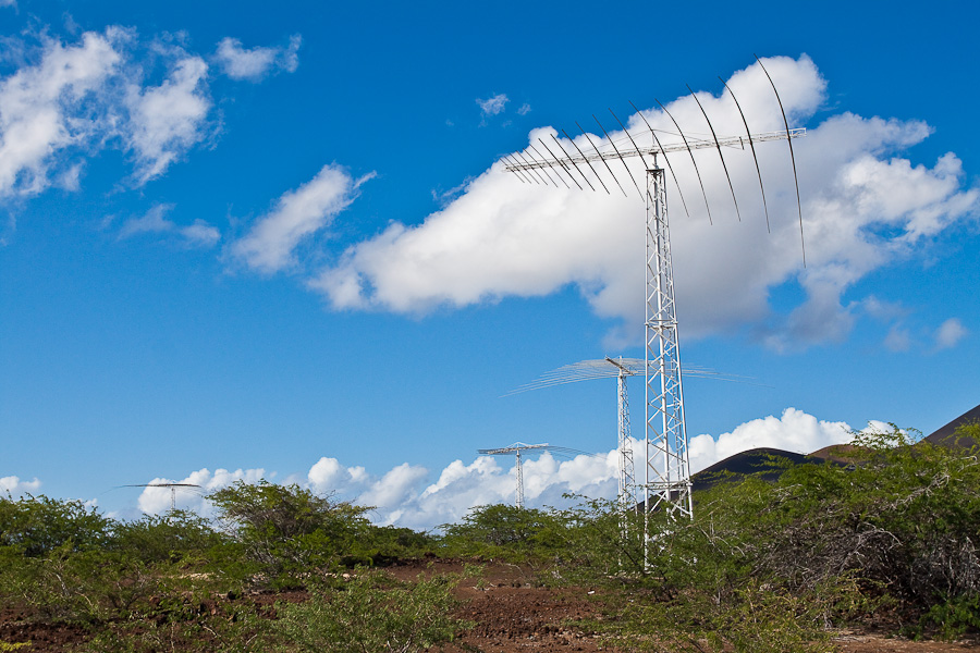
On Ascension Island, everything around contains a horse dose of romance 

In addition to antennas, the island is full of mysterious signs. 
½
The cloud in the background covers the top of the mountain for a reason: unlike the “lunar” surface at sea level, a real rainforest is hiding in the cloud, as in Southeast Asia or on 
Danger, Men Aloft
There are no fences around the antenna fields; the feeders overhead can be reached by hand. You climb for half an hour and inspire yourself that the head hurts from the "strength of the electromagnetic field" 
Radiation Hazard Keep Clear
While sitting in the air-conditioned interior of the car, you have to pinch your side all the time: THIS IS NOT! 
Comfortless Bay
But there are also palm trees in this tropical hell, which looks like a hot pan without oil. Satellite dishes look almost up, not sideways, because it's almost the equator 
BBC Atlantic Relay Station
The cars are numbered in order, starting from 1. To distinguish the numbers from the numbers (hell, why?), a Latin letter is added to the beginning A. Offroad is allowed on the island, and 4x4 has a deep meaning: as soon as you move off the asphalt, you can easily dig over the bridges in this layer of pumice crumble 
The sea temperature varies between 24° and 27°C, depending on the season. There are enough white sandy beaches on the island, but you can swim only in English Bay or Comfortless Bay: in other places, a risky swimmer is immediately carried away to the open Atlantic Ocean. This is how he screams:
— AAAA-AAAA- AAA-AAA- AAAAAA- AAAA- AAAAAA !

In season, all the idyllic beaches are pitted with large holes and trampled by small feet: at night, maturing clutches of the green sea turtle chelonia mydas torn apart and march into the ocean, where they will have a journey full of adventure and danger to Brazil. Seeing a young turtle during the day is a rarity and good luck, but we were lucky! I named this turtle Nikolay) 

By the way, in English language two non-interchangeable words for turtles: turtle - "aquatic turtle" and tortoise - "land turtle". If you call Nicholas tortoise you just won't understand 
Nikolai is photogenic and loves to be photographed) 
But shooting is the tenth thing: the first 20 meters can hardly be called the most difficult, because all the remaining 2300 kilometers to Brazil, the enemies will encroach on Nikolai with approximately the same frequency 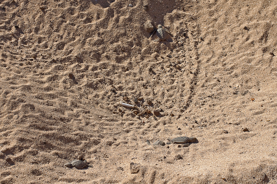
In the photo: Nikolai climbs up the slope against the backdrop of a cigarette butt and dead withered Pavel and Vladimir
Exploding during the day was a bad idea for Nikolai: while we are filming his first 20 meters on the way to the ocean, a local endemic frigate is circling above us fregata aquila rushing straight at us humans. How can we try to brush it off and help Nikolai on his way to the ocean 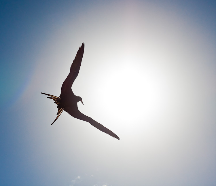
Fregata aquila
Nikolai jumps into the sea and plunges briskly, quickly moving away from the shore 
But the frigate turns out to be more skillful, meaner: at the end of the photo shoot, the hero is devoured 
Fregata aquila with Chelonia myda in the mouth