You can swim only in the Tavdinsky district! All reservoirs of Verkhnyaya Pyshma and Sredneuralsk were rejected by Rospotrebnadzor: not only water, but also sand is contaminated. When is the best time to fly
27.07.201710:07
As of July 24, 2017, only 2 reservoirs in the Sverdlovsk region have the relevant sanitary and epidemiological conclusions: Lake Shchuchye in the Tavdinsky urban district and the East Bank of Lake. Shartash in Yekaterinburg. To date, laboratory studies of the samples taken confirm the compliance of the water of Lake Shchuchye with sanitary standards; samples in the lake Shartash do not meet the sanitary-chemical and microbiological parameters.
Soil samples taken on the beaches did not meet hygienic standards for the following indicators:
The beach of the lake Isetsky in the village of Murzinka, city beach - discrepancy in the index of bacteria of the group coli
The beach of Koptyaki village - discrepancy in the index of bacteria of the E. coli group
The city beach of Kachkanar - discrepancy in the index of bacteria of the Escherichia coli group, in the index of enterococci
The territory of the beach of the Glubochensky reservoir (Polevskoy) - a discrepancy in the index of bacteria of the E. coli group
Beach in Verkhnyaya Sinyachikha village - non-compliance in terms of sanitary and chemical indicators
Unsatisfactory results of water samples taken in reservoirs:
Alapaevsky district
Pond village. Verkhnyaya Sinyachikha - discrepancy in terms of sanitary-chemical and microbiological indicators
R. Neiva (city beach) - discrepancy in terms of sanitary-chemical and microbiological indicators
Rezhevsky district
R. Rezh (microdistrict "Seven Winds", beach "Combat Brotherhood") - discrepancy in terms of sanitary and chemical indicators
Sysert district
R. Sysert - discrepancy in terms of sanitary and chemical indicators
R. Sysert (recreation center "Prometheus") - discrepancy in terms of sanitary and chemical indicators
Polevskoy
Polevskoy Pond - non-compliance in terms of sanitary and chemical indicators
Glubochensky Pond - non-compliance in terms of sanitary and chemical indicators
Shtangovskoye reservoir (dam) - non-compliance in terms of sanitary and chemical indicators
Serovsky district
Yekaterinburg city
Verkh-Isetsky Pond (Big Horse Peninsula - SRK "Kuba") - discrepancy in terms of sanitary and chemical indicators
Verkh-Isetsky Pond (Water Station) - non-compliance in terms of sanitary and chemical indicators
Verkh-Isetsky Pond (beach on Controllers Street) - non-compliance in terms of sanitary and chemical indicators
Lake "Forest Park them. Foresters of Russia" - discrepancy in microbiological indicators
Lake Chusovskoe (settlement Chusovskoye lake) - discrepancy in terms of sanitary and chemical indicators
Lake "Obkomovskie dachas" (Maly Istok village) - discrepancy in terms of sanitary and chemical indicators
Lake Shartash (Southern, Western, Northern and Eastern beaches) - discrepancy in terms of sanitary and chemical indicators
Reservoir Chusovodstroy - non-compliance in terms of sanitary and chemical indicators
Nizhne-Isetsky Pond (microdistrict Khimmash) - discrepancy in terms of sanitary and chemical indicators
Uktus reservoir - discrepancy in terms of sanitary-chemical indicators and microbiological indicators
Pond village. Scrapers - discrepancy in terms of sanitary and chemical indicators
Reservoir gost.Ramada - discrepancy in terms of sanitary and chemical indicators
R. Patrushikha - discrepancy in terms of sanitary-chemical and microbiological indicators
Nizhny Tagil
Lenevskoye reservoir (settlement Lenevka) - discrepancy in terms of sanitary and chemical indicators
Murinsky Ponds (Nizhny Tagil) - non-compliance in terms of sanitary-chemical and microbiological indicators
Nizhny Tagil pond (Goroshnikova street) - non-compliance in terms of sanitary-chemical and microbiological indicators
Nizhne-Vyisky Pond (V.Cherepanov St.) - discrepancy in terms of sanitary-chemical and microbiological indicators
Laisky pond - discrepancy in terms of sanitary-chemical and microbiological indicators
R. Isa, Isinsky tract - discrepancy in terms of sanitary and chemical indicators
Nizhnyaya Salda
Nizhnesaldinsky pond - non-compliance in terms of sanitary and chemical indicators
Asbest
The Bolshoi Reft River (right bank) in the area of the recreation center "Bodrost" - a discrepancy in terms of sanitary and chemical indicators.
The Bolshoy Reft River (left bank) in the area of the recreation center "Bodrost" - a discrepancy in terms of sanitary and chemical indicators.
Kachkanarsky GO
Nizhne-Vyisky reservoir - discrepancy in terms of sanitary and chemical indicators.
Verkhneturinsky GO
Verkhneturinskoye reservoir (Water station) - non-compliance in terms of sanitary and chemical indicators.
Kushvinsky GO
Kushvinskoye reservoir (Vodnaya station) - discrepancy in terms of sanitary-chemical and microbiological indicators.
Irbitsky GO
Lake "Krutoe" - a discrepancy in terms of sanitary and chemical indicators.
R. Irbitka (v. Rechkalovo) - discrepancy in terms of sanitary and chemical indicators
R. Irbitka (v. Melnikova, v. Fomina, v. B. Zvereva) - discrepancy in microbiological indicators
R. Nica (below the city of Irbit) - discrepancy in microbiological indicators
Verkhne-Pyshminsky GO
LLC "Forest Fairy Tale", recreation center "Forest Fairy Tale", Verkhnyaya Pyshma, Romashka settlement, Lake Baltym - discrepancy in terms of sanitary and chemical indicators.
OOO "AN" Rich Dad", recreation center "Shishki", Verkhnyaya Pyshma, Lake Baltym - discrepancy in terms of sanitary and chemical indicators.
OOO " sunny island", recreation center "Solnechny Ostrov", a pond (Verkhnyaya Pyshma, Mostovskoye village) - non-compliance in sanitary and chemical indicators
Oz. Iset (LLC "Gardaria", Recreation center " sunny Beach"") - discrepancy in terms of sanitary-chemical and microbiological indicators
Administration of the municipality Verkhnyaya Pyshma, Verkhnyaya Pyshma, the city beach of Lake Baltym "Zaykovo" - a discrepancy in terms of sanitary and chemical indicators.
Administration of the municipality Verkhnyaya Pyshma, Verkhnyaya Pyshma, Sanatorny village, Baltym lake beach - non-compliance with sanitary and chemical indicators.
Administration of the municipality Verkhnyaya Pyshma, Verkhnyaya Pyshma, the beach of the village of Romashka, Lake Baltym - a discrepancy in terms of sanitary and chemical indicators
Lake Baltym (LLC "Restaurant", "Fire-beach") - discrepancy in terms of sanitary and chemical indicators.
Berezovsky GO
Shilovsky reservoir - discrepancy in terms of sanitary and chemical indicators.
Sredneuralsk
Lake Iset, settlement Koptyaki - discrepancy in terms of sanitary and chemical indicators.
Nevyansk district
- Lake Tavatui (KOL "Stone Flower") - discrepancy in terms of sanitary and chemical indicators
Verkhoturye
R. Aktai - discrepancy in microbiological indicators
R. Tura - discrepancy in microbiological indicators
Talitsky district
Urginsky pond - discrepancy in terms of sanitary-chemical and microbiological indicators
Kamensk-Uralsky GO
R. Kamenka - non-compliance in terms of sanitary and chemical indicators
Lake Sungul - non-compliance in terms of sanitary-chemical and microbiological indicators
Lake Tygish - discrepancy in microbiological indicators
Lake Chervyanoe - discrepancy in microbiological indicators
Kirovgrad GO
Kirovgrad Pond - non-compliance in terms of sanitary-chemical and microbiological indicators
Satisfactory results of water samples were obtained for the following reservoirs:
Alapaevsky district
Pond N. Sinyachikha
Rezhevsky district
R.Rezh (microdistrict "Gavan", GAUZ SO OSBMR "Lipovka" village Lipovka)
Turin GO
River Nitsa (village Krasnoslobodskoe)
Veselinka tract (village Kaltyukova)
Tavdinsky district
Lake Shchuchye
Kamensk-Uralsky GO
R. Pyshma (quarry Silicate)
GO Upper Tagil
Vogul pond
Krasnoufimsky GO
The middle pond of the village of Achit
R. Ufa (beach in the Baraba area)
Pond with. Aleksandrovskoe
Yekaterinburg city
Melt water lake, Novokoltsovsky tract, "EURASIA WAKE PARK"
GO Degtyarsk
R. Chusovaya
Volchansky GO
Pond Kamenka
Karpinsk
- lime quarry
ZATO Free
Open pond Iva
Given the lack of sanitary and epidemiological conclusions on the compliance of most water bodies with sanitary rules, the results of laboratory studies, the Office of Rospotrebnadzor for the Sverdlovsk Region recommends using only Lake Shchuchye in the Tavdinsky District for bathing purposes.
In accordance with clause 3.6. SanPiN 2.1.5.980-00 "Hygienic requirements for the protection of surface water", paragraph 5 of Art. 18 of the Federal Law of March 30, 1999 No. 52-FZ "On the sanitary and epidemiological well-being of the population", executive authorities of the constituent entities of the Russian Federation, local governments, individual entrepreneurs and legal entities, if water bodies pose a danger to public health, are obliged to in accordance with their powers, take measures to limit, suspend or prohibit the use of these water bodies.
You can get a route for the car by entering the name of the place from where you want to leave and where to get. Enter the names of points in the nominative case and in full, with the name of the city or region separated by commas. Otherwise, the wrong path may be laid on the online route map.
Free Yandex-map contains detailed information about the chosen area, including the borders of regions, territories and regions of Russia. In the "layers" section, you can switch the map to the "Satellite" mode, then you will see a satellite image of the selected city. The "People's Map" layer contains metro stations, airports, names of neighborhoods and streets with house numbers. This is an online interactive map - you can not download it.
Nearest hotels (hotels, hostels, apartments, guest houses)
View all hotels in the area on the map
Shown above are the five nearest hotels. Among them there are both ordinary hotels and hotels with several stars, as well as cheap accommodation - hostels, apartments and guest houses. These are usually private mini-hotels of economy class. The hostel is a modern hostel. The apartment is a private apartment with daily rent, and a guest house is a large private house, where the owners themselves usually live and rent rooms for guests. You can rent a guest house with an all-inclusive service, a sauna and other attributes have a nice rest. Check with the owners here.
Usually hotels are located closer to the city center, including inexpensive ones, near the metro or train station. But if this is a resort area, then the best mini-hotels, on the contrary, are located away from the center - on the coast of the sea or river.
Nearest airports
| Type | Name | The code | City | The code | Distance |
| The airport | Roshchino | TJM | Tyumen (RU) | TJM | 99 km. |
When is the best time to fly. Chip flights.
You can choose one of the nearest airports and buy a plane ticket without leaving your seat. The search for the cheapest flights takes place online and you are shown best offers including direct flights. This is usually e-tickets on a promotion or discount from many airlines. Having chosen a suitable date and price, click on it and you will be taken to the official website of the company, where you can book and buy the necessary ticket.
Nearest bus stations, railway stations, bus stops.
| Name | Type | Transport | Distance | Schedule |
| Karatunka, turn | bus stop | bus | 6 km. | Schedule |
| Tavda | bus station | bus | 8 kilometers. | Schedule |
| Saitkovo, turn | bus stop | bus | 8 kilometers. |
Tavda locality
Valery ERMOLAYEV is the author of poetry books, his poems were included in the Anthology of the Poets' Guild, published in 1995 in Yekaterinburg; he is an art critic - he graduated from the Academy of Arts in St. Petersburg and has been studying the folk wooden architecture of the Trans-Urals for many years, and in his native Tavda he is also known as the author of local history essays.
The Tavdinsky district of the Sverdlovsk region is located in the middle reaches of the Tavda River, a tributary of the Tobol, in the forest Trans-Urals, on the western outskirts of one of the most extensive lowlands the globe- West Siberian Plain. The left-bank half of the region's territory is included in the eastern province of the Kondinsky lowland, and the right-bank half, the interfluve of the Tavda and Tura, captures part of the Trans-Ural sloping plain.
The district covers an area of 6539 square kilometers, of which about 3100 are forests, 2500 are swamps, 175 are lakes and rivers, and 442 are agricultural lands. The center of the district, the city of Tavda, is located 360 kilometers east of Yekaterinburg and 125 kilometers north of Tyumen. Geographical coordinates its: 65 degrees 16 minutes east longitude and 58 degrees 03 minutes north latitude. The city covers an area of 160 square kilometers, of which 45 are under construction.
The length of the district in the latitudinal direction is 93 kilometers, in the meridian direction - 110. Occupying the extreme eastern position in the region, it borders on the Taborinsky district in the north, Turinsky district in the west, and Slobodo-Turinsky district in the southwest. Kondinsky districts adjoin from the northeast, Tobolsky districts from the east, and Nizhne-Tavdinsky districts of the Tyumen region from the south.
After the annexation of Siberia to Russia from the end of the 16th century, the Tavda lands were part of the Pelymsky Voivodeship, then Tobolsk, and with the establishment of the provinces in 1708 - in the Koshukskaya volost of the Turin district of the Siberian province, which in 1796 became Tobolsk, in turn renamed in August 1919 in Tyumen. In November 1923, the formed district with the center in the village of Tavda as part of the Irbit district of the Ural region, upon division of which in January 1934, the Verkhne-Tavdinsky district was assigned to the Ob-Irtysh region, soon renamed Omsk. In October 1938, the Tavdinsky district was ceded to the Sverdlovsk region.
Surface

The modern relief is determined by the geological history of the Earth. About 165 million years ago, in the Mesozoic era, the folded mountain structures of the West Siberian Plate, which arose even in the older Paleozoic era, experienced subsidence and were covered by the waters of the oceans. Such subsidence was replaced by uplifts repeatedly during the Cenozoic era, which is closer to us in time, until 30 million years ago the tectonic plate finally rose and the sea waters receded. A thick layer of sedimentary rocks, reaching more than a thousand meters, served as the foundation for the flat relief of Western Siberia. The uppermost horizontal deposits are formed by loose sediments of lakes and rivers in the modern post-glacial era.

Tavdinsky land according to the features of the relief can be divided into three regions. The right bank, somewhat elevated above the eastern left bank, is a vast, slightly dissected arena of river terraces, usually smoothly or in ledges turning into the bedrock bank - the interfluve of the Tavda and Tura. The first floodplain terraces here are low, up to 10 meters, not more than one kilometer wide. The latter are most pronounced, reach a height of 40-50 meters and often break off to Tavda with high cliffs - ravines. The ancient river valley consists of ridges and islands of sandy ridges, 5-12 meters high, with fairly flat peaks and gentle slopes. Absolute heights above sea level here are 100-115 meters. The hollows of ancient drains are oriented along the Tavda, from the northwest to the southeast. Its modern tributaries cut through narrow valleys in the latitudinal direction. The tops of the ridges, closed depressions, other depressions and lowering of the relief are occupied by swamps and lakes. The riverine parts of the terraces are dissected by ravines, logs, ancient and modern. Due to the flatness and forested terrain, ravine erosion is rare and is observed only near the village of Saitkovo.
The structure of the cover of marine continental deposits of the right-bank region is especially clearly observed in riverine outcrops of rocks - in the ravines near the villages of Vaskovo, Saitkovo, Beloyarka. The remains of flora and fauna in the rocks tell both about warmer climatic epochs in the history of the earth, and about glaciation, which began 100-200 thousand years ago and reached Tavda. It is from the Ice Age that the tusks and bones of an ancient mammoth found in a river cliff near Vaskovo have come down to us.
The left bank, approximately limited by the chain of lakes Bolshoe Satykovo, Shaitanskoye, Bolshaya Indra, appears to be a flatter plain with absolute heights of 60-80 meters. Here are low, poorly drained floodplain terraces. Wide stripes of islands and gentle ridges are interspersed with marshy spaces. The second floodplain terraces are rare and form sand banks 12-15 meters high, well observed near the village of Khmelevka and Lake Yanychkov. The relief is disturbed by shallow hollows and logs. Among the swamps, there are often "manes" - oblong sandy ridges from 3 to 10 meters high, sprouted by forest and, for the most part, oriented along the Tavda channel, from which it can be assumed that these are the remains of ancient riverside ramparts.
The third Tavdinsky-Kuminsky interfluve region covers a 20-30 km strip of flat ridges, bounded in the northeast by a belt of upland watershed bogs. Elongated hilly elevations of ridges and ridges, alternating with hollows and oblong hollows, create complex combinations of relief, so that it does not give the impression of monotony and monotony.
The mineral resources of the region are determined by its geological past and are represented by industrial reserves of sand, clay, and peat. SAND is mined all over the territory as needed when laying roads, building dams, for industrial and residential construction. Significant deposits of CLAY, one of which - near the village of Fabrika - is included in the state fund and has been developed by the local brick factory for many decades. The deposit of "white clay" - MERGEL near the village of Koshuki has been known for a long time: local residents used it for whitewashing. Tavdinsky white clay diverged around for tens of miles. In 1934, the Tyumen Exploration Party confirmed the deposit with limestone clay reserves of 40-45 thousand tons and its occurrence at a depth of 2.8 to 5.5 meters. There are known outcrops of GRAVEL, for example, 5 kilometers west of the village of Malinovka on an area of 5 hectares, suitable as a building material. In the coastal ravines of Tavda, for example, near the village of Vaskovo, there is an outlet of BOXITES.
Information about the finds in the 1930s of GOLD in the upper reaches of the Karabashka and on the lands of the Krutinsky village council has been preserved. At the same time, geologist Kukartsev discovered signs of OIL on the Belaya River, and Lushchanov's electrical exploration party confirmed oil deposits in an area of 15 square kilometers. The prospect of discovering an oil field in the Tavda basin is supported by modern scientific evidence.
Ptavdinye is part of the West Siberian artesian basin, one of the largest in the world. In 1959, while drilling a deep well for oil three kilometers south of the city iodine-bromine chloride-sodium thermal MINERAL WATER was opened. Since 1961, it has been used for balneological purposes in the local balneary, and since the spring of 1994, its industrial bottling and sale in the Ural region has been established.
In terms of its healing properties, Tavda water is comparable to the famous Borjomi and helps in the treatment of diseases of the liver, biliary tract, and the musculoskeletal system.
About 30 wells have also been drilled and equipped in the region, providing fresh water suitable for drinking.
Tavdinsky swamps are rich in peat deposits. In recent years, the swamps of Shabalino, Mikhailovskoye, Ventino, Podelnichnoye, Pereyma and others have been developed. The developed areas occupy more than 30 hectares, peat reserves in them amount to 13 million tons. Dozens more peat bogs are waiting in the wings. Peat layers lie at a depth of one to four meters, and their thickness reaches six meters. Poorly decomposed peat predominates, not very suitable as a fuel, but is a valuable fertilizer.
Climate

Tavda is located in a zone of sharply continental climate, where winters are long, snowy and severe, and summers are short, humid and moderately warm. The formation of the weather mainly depends on the air masses coming from the west, born over the Atlantic. Having reached the Trans-Urals, they lose a lot of moisture, but still bring a significant amount of precipitation. Following the Atlantic cyclones, the cold masses of the Arctic rush here. Hence the sharp change in weather, the frequency is noticeable during the day, the return of the cold spring, the instability of heat in the summer.
According to long-term observations, the average annual air temperature is +1 degree. The coldest month is January average temperature- 17, the warmest - July with + 17.8. The absolute minimum reached - 38 degrees. Spring comes at the end of March. The average date of the last frost is May 23, the first one is September 19. Frosts are not uncommon in the first decade of June. The duration of the frost-free period is 118 days. Snow cover lasts from 1387 to 177 days. The average snow height is 34 centimeters, but can reach 60-70. The soil freezes to a depth of 50 to 175 centimeters. With early high snow cover in the forest, soils can go into winter without freezing, while seasonal permafrost in other years persists until June. On average, the establishment of a stable snow cover occurs in the first ten days of November, and the melting occurs in the first ten days of April.
Atmospheric precipitation falls mainly in the warm period: 75% of 468 millimeters of the annual amount. The average relative humidity is 71%. The maximum of overcast cloudy days falls on October-November, the minimum is in June. Throughout the year, the southwest wind prevails (22% of the frequency of this rhumb on the wind rose), but the west and south are also frequent. Strong winds are rare, mostly light to moderate.
Fogs are most frequent in August, September and December, most likely in the morning, in the interval "an hour before sunrise - an hour after sunrise". Blizzards, contrary to popular belief, often occur not in February, but in November - December. Half of the total number of thunderstorms (an average of 24 per year) occurs in June. Two - three times more likely at the beginning of winter, there is ice.
It should be noted that the north and south of the region are quite noticeably different in terms of climatic characteristics. So, the average annual temperature in the north is about +0.2 degrees, the precipitation there grows up to 497 millimeters, the snow cover is 20 centimeters more than in the south, the minimum temperature reaches -50 degrees.
It remains to add that the local weather is characterized by significant seasonal and annual fluctuations. For example, for the first time in the last 6-7 decades, in November 1998, a record low temperature was recorded in Tavda - minus 43 degrees! And in 1996, the snow cover appeared only in December on the very eve of the new year, and all the reservoirs of the region were ideal skating rinks. Noted in recent times noticeable weather changes make it possible to judge some warming of the climate, which is also confirmed in the data of instrumental observations, which have been conducted since 1943 by the Tavdinsky meteorological station.
Rivers

A fairly humid climate and flat relief, which makes drainage difficult, explain the presence in the region of an extensive system of lakes and swamps, but a less developed river network. The largest river of the region, Tavda, flows from the northwest to the southeast of the region, taking on the left the tributaries Karabashka, Chekshanka and Ivanovka, and on the right Posolka, Konya, Oshmarka, Belenichnaya, Azanka, Karatunka, Desyatkina, Bilkina and Peganka. The drain of the system of lakes and swamps in the extreme east of the region is the Laima River, which belongs to the Irtysh basin, the Tegen with tributaries, originating in the swamps of the southwestern outskirts, flows into Tura.
Water in rivers with low salinity, clean. The food is mixed: being mainly the drains of lakes and swamps, the rivers are fed by atmospheric precipitation, groundwater and melt water. In total, there are about 70 rivers and streams in the region.

TAVDA is a left tributary of the Tobol. Dina is 719 kilometers, 112 flows within the region. The basin area is 88,100 square kilometers. It begins at the confluence of Lozva and Sosva. The most significant tributaries are Pelym, Vagil, Chernaya, Volchimya, Taborinka, Emelyashevka, Iksa, Karabashka. Width on average up to 250 meters, depth 3-8. The current is quite fast: from 0.4 to 0.8 meters per second. In the spring, it dumps 60% of the annual runoff. The average water flow near the city of Tavda, 237 kilometers from the mouth, is 462 cubic meters per second, the largest during the flood is 3250. The annual range of fluctuations in the water level in the river, according to observations since 1911, is about 5.5 meters. During high water, the river rises on average by 707 centimeters, at least 253. Catastrophic floods were observed in 1914 - 924 centimeters from the low water, in 1957 - 918, in 1979 - 942. Low levels are also frequent, leading to the closure of navigation on the river: in 1980 year - 107 centimeters, in 1988 - 97. During such periods, the depth on the rifts does not exceed 50 - 60 centimeters. Peaks of water rise are observed from May 20 to June 20, but anomalies occur, as in recent 1994, when high water lasted until mid-September, and its maximum - 824 centimeters - was on August 31.
The river freezes at the beginning of November, opens at the end of April. It is navigable throughout from May to October. It has been floating for many decades. Mole rafting has been banned since 1969, later timber rafting was banned.
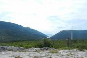
The Tavda flows in a wide valley, its channel is pressed against the right bank, which sometimes breaks off to the river in high ravines, from where wonderful views of the water belt and the forest district open up. There are several such ravines within the region: Bely, Krasny, Karatunovsky, Saitkovsky, Vaskovsky. In the left-bank part of the valley, two floodplain terraces are well expressed. The floodplain is overgrown with willow and willow forests, less often with pine and birch forests, and is quite rich in meadows.
The river is accompanied by a system of oxbow lakes. Their birth can be observed in our time. Near the village of Koshuki, the river laid a second channel - a “breakthrough”, forming a multi-kilometer island. Over time, one of the channels will remain, and the other will turn into a page. Large pages, like Tormolskaya, Doschanoe, Khalturino, Karabashevo, Guzeevo, stretched for 6-10 kilometers.
Tavda, despite the ongoing pollution by industrial effluents, is known for spawning nelma, sterlet and Siberian sturgeon come here, in total there are more than twenty-five fish.
AZANKA - the source of Lake Korobeynikovo, flows east for about 50 kilometers to the confluence with Tavda. At first, the river is swampy, then it runs among mixed forests in a narrow valley with well-defined terraces and crests of the native banks. Closer to the mouth, the river is surrounded by pine forests, the floodplain expands, meadows and small pages appear. The water is clear with a dark brown tint. In the years 1930-1940, timber was rafted along the river. In the old days, before the construction of a hydrolysis plant at the mouth of the treatment plant, it abounded in fish. The surrounding forests are famous for mushrooms and berry places.
The river basin is quite extensive. Azanka is fed by a dozen small rivers. BATAUSHKA flows out of the Bitbaevsky swamp on the western outskirts of the region and after 9 kilometers flows into Korobeynikovo Lake from the south. Somewhat to the north, in the Saragul swamp, MAlushka begins, which, having received several streams, after 15 kilometers flows into the Azanka on the left. Nearby, NIGERUSKA brings its clean, brown-colored water. It is about 15 kilometers long, flows out of the same swamp, one of its tributaries has the name SHUMOK. The last left tributary of the Azanka - BERESTYANKA - flows from the forests from the north, 6 kilometers long.
From the swamp Shchelkanov Ryam west of the lake Overgrown carries reddish-brown water saturated with marsh iron oxides RZHAVETS, the first right tributary of the Azanka, 17 kilometers long. On average, its course is crossed by the highway to Turinsk. BIG EARTH emerges from the Bolshaya Poplavukha swamp, accepting several streams and a small river BLACKCURRANT, merges at the very mouth with SMALL EARTH. The latter originates in the Magpie swamp and flows through the village of Zemlyanoye, where in the 1930s a small pond was built on it, which attracts with its picturesqueness and cleanliness. The surrounding forests are gradually recovering from intensive logging in the past and attract with an abundance of upland game and berries. In a narrow valley, overgrown with spruce, fir and cedar, it runs its 7 kilometers and flows into the village of Spruce Quarry. The last right tributary of the Azanka is a small ELOVKA, half of its way flows within the city, representing a chain of ponds that feed the city estates and garden plots of the southwestern outskirts.
BELENICHNAYA - the right tributary of the Tavda, 6 kilometers long, drains a section of the floodplain with a dozen small oxbow lakes. In high water, they all turn into one lake, on the shore of which the village of Belenichnoye is picturesquely located.
BILKINKA is the right tributary, originating from the forest springs to the west of the village of Koshuki. Half of its 12 km path flows in a slightly swampy ravine, overgrown with forest. Coming out to Tavda, it forms a large floodplain meadow interspersed with tiny lakes. In the spring it is almost completely flooded. Waterfowl nest here, fish are found: pike, perch, ide, crucian carp, chebak. After the water drains, the meadow is used as a pasture.
The only right tributary, the MALINOVKA, starts from the northern edge of the Lipovsky swamp and, in turn, receives the small rivers KRUTUA and RICHHA, on which the village of Lipovka stood until 1971. In the vicinity of these rivers there are many berry places of blueberries and strawberries, a hare, a fox, and game are found. Archaeological sites along the banks indicate that they have been inhabited for a long time. By the way, one of the options for translating the toponym Biltina (the outdated name of the river) from the Mansi language is “Rich Berry River”.
DESYATKINA - originates in a swampy forest south of the city and after 18 kilometers flows into Tavda on the right near the village of Vaganovo. It is fed by several streams, on one of which in the Holy Log since the 1920s there has been a place revered by local Orthodox believers, associated with the name of St. Nicholas the Wonderworker. The floodplain of the river along its entire length is a meadow overgrown with forest. In the middle reaches there is a pond used as a watering place. Not far from the mouth, the river is crossed by the Tavda-Tyumen road.
IVANOVKA - the left tributary of the Tavda at the place where it leaves the district. It drains a vast area of the floodplain, accepting the runoff of small oxbow lakes - the LUGOVAYA and Srednyaya rivers, as well as many springs and streams. In the lower reaches, it is the drain of the Vaskovskaya oxbow lake. The water is clear and clear. Until the early 1960s, there was a settlement of Ivanovka on the river.
KARABASHKA is a large left tributary of the Tavda, 146 kilometers long, the basin of which is about a third of the area of the region. It originates at the northern border in the Kumal swamp and flows below the village of Saitkovo. Absolute water level marks: in the middle course, at the confluence of the tributary of the Mass - 57 meters, at the mouth - 46. The flow rate is 0.2 - 0.3 meters per second, the depth is 2-3 meters.
The banks of the river and its tributaries have long been inhabited; archeological monuments dating back to the second millennium BC have been found here. Until the 1960s, there were more than ten settlements here. Now there are three of them left: the village of Karabashka, the villages of Mostovka and Khmelevka. The toponym Karabashka goes back to the Tatar language and is interpreted as a “black peak”, which is supported by the dark color of the water. Interestingly, the main tributary bears the "opposite" name - the Belaya River.
Karabashka is a spawning river, it is home to ide, pike, perch, chebak, in numerous old men of the lower reaches - crucian carp and a rare tench. The Karabashsky beaver reserve was formed, where the animals brought from the Voronezh region took root well. forest land and the swamps around abound with all sorts of living creatures, berries and mushrooms. There are many hay meadows here. And in the past, there were several mills on the river, and in the village of Mostovka in the 1930-1950s a small hydroelectric power station operated. In the northern part of the basin, the Karabash timber industry enterprise carries out significant timber harvesting.
Thanks to natural wealth and the beauty of this taiga river attracts the townspeople. Dacha settlements appeared on the lands of the former villages of Pokrovka and Grishino. The development of these places is facilitated good roads to Mostovka and Gerasimovka, crossing the river, and in the future - the road to Konda planned for construction.
On the right, the tributaries Tatarka, Massa, Belaya flow into Karabashka, on the left - Malaya Karabashka, Khmelevka, Istok (Olkhovka), Mostovoy. Tatarka is a 5 km long river flowing in the area of intensive logging. On its banks in the first half of the century there was a village - namesake. A mysterious MASS flows from the swamps, taking several nameless streams on its way for 39 kilometers. WHITE at the beginning is more like an oxbow lake: from a helicopter, a wide ribbon of a river clearly stands out against the background of an endless clean swamp, with rare islands of manes. Light brown water. Fish are found here, beavers and minks live. Especially surprising is the extremely large crucian carp.
SMALL KARABASHKA flows just above the village of Karabashka. KHMELYOVKA - flows from a large berry Kumbay swamp, extending north of Shaitansky Lake. The water is dark but clear. In the pools you can catch a large black-backed perch. The MOSTOVOY creek, which dries up in the summer, gave its name to a fairly large village. A small swamp river ARCHINKA, also called Serginskaya, flows into Yanychkoye Lake. Despite its size, it is mentioned on a seventeenth-century map by Semyon Remezov, which is naturally surprising. Or did this toponym still refer to another geographical feature, or in those distant times, the river stood out for something. Maybe an abundance of berries in the adjacent swamps? From the same lake flows the river Istok, or Olkhovka. Its upper course passes through a swampy meadow, then through pine forests. There is an interesting archaeological monument on it: the ancient settlement and the Yanychkovo settlement.
KARATUNKA - flows out of Lake Istochnoye in the south of the district and flows into Tavda within the city. It flows in the forests throughout its length, only in the upper reaches the floodplain is swampy. The water is clean, its chemical composition, not least of all, was the reason that a cloth factory appeared on the river in the 1870s. In the old days, there were up to five mills on Karatunka. The factory dam held a large pond until 1947. There are plans to restore it and create an urban recreation area here. The full flow of the river is facilitated by a large number of springs, streams and several larger tributaries flowing into it. These are the BOLTANKA, flowing from the Maly Purzhit swamp, and another right tributary of the BORDYANKA, which flows into the city microdistrict of the fankombinat and is better known as PERESKOK. This stream flows in a deep, forested ravine, surrounded by a good pine forest.
On the left, the SHCHYA, the source of the lake of the same name, flows in, having traveled a path of 9 kilometers through the thickets of a mixed forest, which rises in place of a once ruthlessly cut down pine forest. A little lower flows the BIG MAZHOVKA, which has taken the SMALL MAZHOVKA from the village Big Desert where there is a pond. A tiny CURVE flows near the village of Fabrika, water flows into it from mineral spring used by the hydropathic, and it is difficult to determine which water is more in the river - river or underground.
KONYA is a forest stream about 4 kilometers long, flowing into Tavda just below the village of Beloyarka. It flows in high banks with traces of ancient settlements. The name from the Mansi can be translated as "a river flowing out." The mouth attracts fans of winter fishing.
LAYMA - is the drain of a whole system of lakes: Small and Big Satykov, Tormyshkovo, Ivanovo and several more already within the Tyumen region. Spawning. The surrounding swamps are known for good mowing.
OSHMARKA - formed by the confluence of Bolshaya and Malaya Oshmarok, after which, after 7 kilometers, it flows into Tavda. Very winding, with an extended floodplain in the oxbow lakes. The edge of the native banks is replete with traces of the life of ancient tribes. THE BIG BREAK starts in the swamp north of the village Azanka and flows about 20 kilometers east to the confluence with SMALL OSHMARK, which is the drain of the Zybun swamp. The forests around were intensively cut down, rich in thickets of raspberries and currants. On a small tributary - the KRUTOI river there is a village of the same name, where a pond is arranged.
PAVYA - flows along the northwestern outskirts of the district and flows into Tavda in the Taborinsky district. A small NYUKSA flows into it, flowing in the forests west of the village of Beloyarka. In the 1950s and 1960s, there was a lumber camp with the same name on the river.
PEGANKA - starts from the confluence of two rivers GODOVOCCHNY and BLACK on the outskirts of the large Lipovsky swamp and flows through dense forests to the confluence near the village of Vasskogo. The floodplain is narrow, the banks are high, there are rich blueberry and wild strawberry berries around. From the Lipovsky swamp, the KOCCHKA begins, flowing in a gently sloping, sometimes swampy forest, flowing into the Peganka on the left.
POSOLKA, or BELOYARKA - is born in a pine forest, flows in a narrow ravine, picturesquely overgrown with tall fir trees. Having circled the village of Beloyarka, it takes RIP. This full-flowing river, together with its tributaries KARABEYKA, is the drain of several floodplain lakes, of which the largest are Dry, Tarta, Wild. The embassy flows into the Tavduv in a beautiful bend, at the edge of the high White Yar. In the old days, the village located on the mountain was called Beloyarskaya Posolka. Mansi "ambassador", "ambassador" denotes the channel of the river.
TEGEN - born in the Tegen swamp in the south-west of the region, the river receives several tributaries and goes to the Slobodo-Turinsky region. The water is clean, with a marsh tint and taste. During the spawning period, fish from Tura comes here. Does not freeze in winter. There is a mink, a muskrat, beavers have been seen in recent years. Along the banks, there are cedar forests, many thickets of currants and raspberries. From the left, the BICHAZHKA and the BOLSHAYA KUCHAZH flow into it, with a tributary of the SMALL KUCHAZH. The first two originate in the Sennoye swamp, and the third in the Karanin swamp. On the right, RZHAVETS flows into Tegen with a tributary - the DRY rivulet, Postninsky Ryam flows out of the swamp, and below - ISHKULKA.
CHEKSHANKA is a small but full-flowing tributary of the Tavda, flowing from the Simnik swamp below the Tormolskaya oxbow lake. Having passed half of its 11-kilometer path to the north, the river turns south and flows parallel to Tavda. Mesopotamia is deserved, rich in herbs. The river is spawning.
lakes

About two hundred natural reservoirs are located in the region: from tiny starets to large riding lakes with a mirror of tens of square kilometers, such as Bolshaya Indra, Shaitanskoye, Yanychkovo, Bolshoye Satykovo, Noskinbash. There are especially many lakes in the left-bank part. Dozens of oxbow lakes have formed in the Tavda floodplain, sometimes with an area of hundreds of hectares. The right-bank lakes between the Tavda and Tura rivers are distinguished by their round shape and lighter water. Most of the upper lakes are shallow, 2-3 meters deep, subject to flowering and overgrowing, the waters in them have a dark peaty tint and marsh flavor. The bottom is silty covered with a layer of mud (local variants of the name: "nyasha", "botka"), reaching several meters. Reservoirs rich in healing sapropel deposits are not uncommon.
Lakes are used for water supply of the population. For example, a conduit from Khalturino supplies the city. Rich fish stocks, especially crucian carp, make it possible to catch several hundred tons a year. Sapropel began to be mined as a fertilizer for the fields and a medicinal substance. Some lakes with non-marshy shores and natural sandy beaches, such as Karabashevo, Guzeevo, Khalturino, Morozko, Zarosloe, which have good access roads, have become recreation areas for Tavdinians.
ARCHIN is a lake with an area of 7 hectares, lost in a swamp between lakes Yanychkovo and Shaitanskoe. Accessible along the trail from the village of Gerasimovka. There is a small carp.
NAMED - a lake in the Tegeni basin, 3 meters deep and 3 hectares in area. There is carp. Approach along the trail from the former narrow-gauge road Azanka - Karanino.
BIG INDRA is the largest upper lake not only in the Tavda basin, but also in the entire eastern part of the region: it reaches 8.5 kilometers in diameter, the mirror area is 33.5 sq. km. Located on the northern edge of the region. Mentioned by the famous researcher of Siberia of the XIX century P.A. Slovtsov. The absolute mark of the water level is 63 meters. The water is fresh with a yellowish tint. In numerous furrows on the bottom, which fishermen call "golden pits", there are depths of up to 4 meters. Carp catches can reach 300 tons per year. In not in large numbers pike, perch, chebak are found. The shores are swampy, manes covered with pines approach from the southwest. The fishing village is located on the west coast. A narrow-gauge railway was laid from it to the lake through the swamp for the export of caught fish. In summer, you can get here only by air, in winter - from the village of Karabashka or the village of Palmino along the winter road.
SMALL and BIG SUITALKI - stagnant lakes in the swamps between the Belaya and Karabashka rivers, 9 km south of Bolshaya Indra. The area is 53 and 8 hectares, respectively. The water is clear with a yellow-green tint. Carp and minnow are found. Archaeological monuments have been preserved in the vicinity on the manes.
BOLSHOE and SMALL WILD - are located 5-7 kilometers east of the village of Mostovka, between the lakes Shaitanskoye and Yanychkoye. Areas of 280 and 40 hectares. The level mark of the Big Wild is 59.6 meters. Non-flowing, waterlogged banks. Dark tinted water. Carp, minnow. Entrance from Mostovka.
BIG and SMALL KARABASHEV are located in the swamps of the extreme north of the region. Approaches are difficult. There is carp. Areas 46 and 27 hectares.
BOLSHOE and SMALL OKUNYOVO are located in the Malaya Poplaukha swamp, two kilometers from Lake Srednee to the northwest. Areas 34 and 3 hectares. Accessible along the trails from Sredny and the former narrow-gauge railway from the village of Karer. There is a large, up to two kilograms, perch. According to the testimonies of fishermen, sometimes Bolshoye Okunevo begins to "seeth" and burnt stumps and tree trunks float to its surface. This phenomenon, as well as a large depth of up to 10 meters, shed light on the origin of the lake. Perhaps it was formed when a burnt powerful peat bog was filled with water. There is a fishing hut on the northeastern shore of the lake.
BOLSHOE and SMALL SATYKOV - located 12-14 kilometers northeast of the village of Gorodishche and 5-6 from Gerasimovka. Hence the entrances. The lakes are connected by the river Laima, which begins here, as well as by an reclamation canal in the 1980s, which leads to the overgrowth of the channel. The water intake area is about 300 sq. km. Areas of the water mirror: 13.1 and 4.6 sq. km. Level marks: Small - 57.8, Large - 57.4. Islands of swampy forest approach the shores. The water is clean and transparent, quite tasty golden crucian is found in it, and ide, perch, and chebak come to spawn along the Laima. There are large deposits of sapropel at the bottom of the lake.
VAGANOVO (outdated name - Poganoe) - is located 13 kilometers northwest of the village of Tagiltsy. The area is 264 hectares, the level mark is 57.8 meters. Non-flowing. The shores are swampy, with cranberries and lingonberries. The water is light yellowish, crucian carp, tench, minnow live in it. Swans, geese, ducks nest. On the south side, the village of Tumba once stood: along the old road you can get here to the lake now.
VALGARSKOE - a lake 6 kilometers north of the site of the former village of Tonkaya Grivka. Tatars from the village of Eskalby, located nearby, call it Voncharkul. There is carp. The surrounding swamps are rich in berries. High manes have preserved cedar patches.
VASKOVSKAYA STARITSA - named after the village opposite Tavda, with which it is connected by a canal and a river Ivanovka. Known for good fishing, fish from the river come here to spawn. Along the banks are grass-rich water meadows.
GAGARI - swamp lakes with an area of 4 and 1 ha. One 2 km north east of the lake Source, another not far from Karanino.
DEEP - a lake with an area of 40 hectares, in the floodplain of Tavda and connected with it by a channel. Depth up to 8 meters. On the high western coast there is a recreation center "Khimik" of the hydrolysis plant. Preserved nearby ancient settlement. They get here along an improved forest road from the village of Belenichnoye.
GUZEEVO is a large left-bank oxbow lake of Tavda, on the high beautiful bank of which the village of Gorodishche is located. The area is 96 hectares, the depth at low water is up to 3 meters, the length of the lake horseshoe is 6 km. There are a lot of lake and river fish in the clear clear water. The inner floodplain is continuous mowing meadows.
WILD - a lake with an area of 84 hectares near the eastern border of the district in the Laima basin. Carp and minnow are found. Hard to reach. Surrounded by rich hunting grounds. Elk, wild boar, hare, fox, wolf live here.
DOSCHANOE - the left-bank oxbow lake of Tavda, 5 km northwest of the village of Tagiltsy. Horseshoe-shaped, 5 km long, with an area of 69 hectares. In high water, it merges with the Istok river flowing along the northern and western periphery and, through it, with the river. Formed inside big Island. From the east, the river Ustinkina flows into the oxbow.
Dukhovoye is a lake in the Laima basin, 3 km east of Bolshoye Satykovo Lake. Flowing: in the southern deeper part, a channel in Laima. Area 31 hectares. Only carp live.
Spruce is a stagnant lake in the Laima basin with an area of about 10 hectares, among a swampy mixed forest. There is carp and minnow.
ZAROSLOE - 10 km from the village of Azanka. The area is about 100 hectares, the depth is up to 2.5 meters. From the north and from the east, the banks are surrounded by pine forests, from the southern edge, vast bolts begin, rich in cranberries, lingonberries, blueberries - Postninsky and Shchelkanov Ryamy. Subject to overgrowth: the northern water area is covered with islands. Perch and chebak are found in clear water. On the north coast there is a country health camp "Ogonyok".
Ivanovo is a flowing lake: Laima flows through it. Small, growing. The crucian is shrinking. In the spring, river fish come. There is a paved road leading to the lake from the village of Kiselevo.
Istochnoye is the largest in the right-bank part of the district, 25 km south of the city. Karatunka originates in the lake. The water level mark is 96.1 meters, the shore mark on the eastern forested side is 99 meters. There is a forest cordon here. Perch, pike, ide, chebak, crucian carp and minnow are found. A rather broken road goes here from the village of Novoselovka. The area of the lake is 568 hectares.
KABAEVO is a raised lake with an area of 51 hectares, 6 km north of the village of Tagiltsy. The shores are swampy. Carp live in clear water. The Ustinkina River and the Rzhavets Mostovoy stream flow out of the lake.
KAYRUK, or GRIVKINSKOE - a lake in a swamp to the east of Shaitansky. Area 22 ha. Overgrown with reeds. It is named after a Tatar fisherman from Eskalbov, who lived here for many years in the summer. The second name is from a nearby village. Carp and minnow are found.
KANTYPKA - 4 km east of the Rusaki village. The area is 92 hectares. Surrounded by bots, interrupted only from the north by the edge of Seliverst pine forest. Approach from the south along the trail from the country road Tagiltsy-Rusaki. The water is yellowish, there is carp. The middle of the lake is shallow, islands have formed here, abounding with nesting nests of ducks and tern gulls.
KARABASHEVO is a left-bank oxbow about 8 km long, just below the mouth of Karabashka. There are river and lake fish. The outer shore reaches a considerable height above the surface of the lake and is very picturesque. Here are the recreation centers "Chaika" of the mechanical plant, road workers and, until recently, the camp site "Youth". There are good roads to and around the lake.
KARANINO is located in the Tegeni basin. The area is 270 hectares, the water level is 98.7 meters. The water is brown, crucian carp and a rather large minnow live in it. The southern shore is elevated above the swamp; until 1975, there was a settlement on it, to which a narrow-gauge railway came. You can get to the lake along the preserved roadbed: 45 km from Azanka, 35 km from Carter.
KARASYE - non-flowing, with an area of 45 hectares, 12 km from the city, not far from the railroad track on Ustye-Akha. Small, with "pits" where large carp are found.
KARPOVO - with an area of 3 hectares, at the southern border of the district, 1.5 km southeast of Karanino. Peaty water. Carp. Sometimes on maps it is designated as crucian. Surrounded by a swamp.
KONDYREVO - located on the southeastern edge of the Lipovsky swamp, 8 km to the west of Vaskovo. Nearby there are two very tiny lakes. All three lakes are often referred to as Kingirskie. They are also protected by very dark water and a complete absence of fish.
HEMP or LAKE OF WHITE LILIES - is located in the right-bank floodplain of Tavda, 2.5 km below the mouth of the Karatunka. Area 12 hectares. The banks are overgrown with mixed forest with a predominance of spruce. From the south, a high root bank of the river rises, where a holiday village is developing. There is also a tiny sandy beach. Carp, perch, chebak are found.
KOROBEINIKOVO is a riding lake, on the northern elevated shore of which the village of Azanka is located. The area is 188 hectares, the mark of the water's edge is 62.6 meters. Flowing: Bataushka flows in, Azanka flows out.
Krivoe is a left-bank oxbow lake within the city, located in a horseshoe shape between the villages of Shipyard and Indra. In the deeper southern part there is a pier - the base of the river fleet.
KULUKHOVSKOE is a deaf lake on the eastern outskirts of the region with an area of 7 hectares. Named after a village that existed nearby. Known for nesting swans.
SMALL INDRA - is located three kilometers west of Big Indra. The area is 156 hectares, the level mark is 61.9 meters. Carp, minnow. Hard to reach.
MASS - in the basin of the river of the same name. 40 ha.
MATYUSHINO - 7 km northeast of the village of Tagiltsy. 155 ha., level mark 54.6 meters. Quicksilver shores and berry patches. Carp. Approach from the south of the logging road along the gats.
MOROZKO is a left-bank oxbow lake 6 km long, crossed in the middle of the iron and highways. There is also a city beach here. On the outer shore are the remains of ancient settlements.
NOSKINBASH, or ESKALBY, is a large raised lake with an area of 2144 hectares, of which only 451 belong to the Tavdinsky district, on the northeastern border. The second name is from the local fishing village. The Noska, a tributary of the Irtysh, flows out of the lakes. Tatar "Noskinbash" - the peak of Noska. The water mark is 64 meters. Surrounded by swamps and accessible only by winter road. Carp, perch, pike, chebak are found; here lives the only one in the area of herds at the price of peled-cheese.
Nyurma - 3 km south of Big Indra. hard to reach. The area is 68 hectares. Large carp are caught in clean water with a light brown tint. On the south side, on a spruce mane, there is a solid fishing hut of the coompromkhoz. A possible translation of the toponym from the Mansi: "nur" - a swamp, "ma" - a place, a swamp.
Okunevo - 3 km southeast of Lenino. 28 ha. Perch and pike are found in small numbers. Approach from the road Tavda - Lenino. The shores are swampy.
PARTY (PARTA) - located in a swamp, 6 km east of the village of Tormoli First. The area is 68 hectares. Carp. Approaches are difficult.
PATRIKEEVO is a lake with an area of about 5 hectares, 2 km east of Yanychkoye Lake. Fishermen sometimes get here along the old logging road from Gerasimovka to catch small but tasty silver carp.
SANDY - a round raised lake of 82 hectares among the vast swamps of the southwest, 7 km from Zarosloe, from where it goes through Zemlyanoye. The depth is up to 3 meters, the water is clear, light, the bottom is sandy. There is a pike. The lake is decorated with a pine forest that has approached the northeast on a high, dry shore.
Podmysnoye - a lake with an area of 9 hectares in the Tegen swamp. Depth up to 3 meters, the bottom is muddy. It is occupied by crucian carp and large minnow, but you can catch pike and chebak. The shores are quicksand, on the western side there are cranberry patches. Approach along the path through the tract Podmysny Ostrov from the canvas of the former narrow-gauge railway from the Quarry.
PUKHTA - is located among the quick swamp, two kilometers north of Lake Tumba. 39 ha. Carp.
LIGHT - in the interfluve of Karabashka and Belaya, 5 km north of Shaitansky. 5 ha. Karasevoe. Accessible along the trail from the road Gerasimovka - Karabashka.
NORTH - lost in the Kumbai swamp, 5 km north of Shaitan. 5 ha. Karasevoe. Accessible along the trail from the road Gerasimovka - Karabashka.
MIDDLE - a large lake in the south, 34 km from the city. The area is 417 hectares, the water level mark is 98.3. The shores are swamped, from the west the reserved Srednensky pine forest adjoins. The road from Istochny leads to the forest cordon. Perch lives in clear water, which attracts fans of winter fishing, and there are many berries in the swamp.
STANOVOE - gives rise to Tegeni. The area is 20 hectares. The bottom is muddy, the water is brown, the depth is 1.5 meters. Karasevoe. Fisherman's hut on the southern shore. Approach along the trail from the 27th kilometer of the former narrow-gauge railway from the Quarry. The name comes from the permanent hayfield located to the south.
Suslyakovo is a lake in the floodplain of Laima. About 2 ha. There is a small carp. According to legend, it was named after a fisherman from the village of Gorodishche who once drowned in it.
TAVLEEVO is a right-bank oxbow lake about 5 km long and 25 hectares in area. In low water, the middle part dries up, and the lake becomes like a torn horseshoe. A chain of ancient settlements stretches along the elevated upper bank. Accessible from the Tavda-Koshuki road and from Saitkovo.
TAGILSKOE - an oxbow lake in the right-bank floodplain of Tavda, more than three kilometers long. Nearby are many more tiny old women. On the south coast there is a recreation camp "Forest Fairy Tale". The toponym, most likely, goes back to the South Mansi "tagil" - a channel, a branch of the river.
TAYMEYEVO - in the swamp behind the Srednensky pine forest. 18 ha. Paint, minnow, ready to be caught on a bare hook. Around sedge marshes with good mowing. They get here along the paths from the cordon on Sredny, from Lake Istochnoye.
TORMOLSKOE is a left-bank oxbow lake with an area of 138 hectares. The level mark is 57.4 meters. There are inlet and outlet channels to Tavda. There are numerous traces of ancient settlements on the banks. River fish and carp.
TORMYSHKOVO is a flowing lake in the floodplain of Laima with an area of 134 hectares. The bottom is muddy, with deposits of sapropel. Water is subject to "flowering". Part of the fish coming to spawn remains to winter. There are good mowings on the banks. Until the 1960s, there was a subsidiary farm and a small settlement here.
TUMBA - 15 km northeast of Tagiltsy. The area is 551 hectares, the level mark is 55.9 meters. Small, imperceptible. Bolta around are rich in cranberries, cloudberries come across. The expanse of the lake expressively enliven the islands in the northern part. Hence the toponym: Mansiysk "tump" - an island. Carp, tench, minnow, pike are found. In summer, there are many waterfowl nesting sites along the banks.
TYAPKINO is a lake with an area of 71 hectares in bolts, 6 km west of the Big Indra. Peaty water. Carp, minnow. Approach along the winter road from the village of Palmino, Taborinsky district.
Khalturino - the left-bank old woman of Tavda. Drinking reservoir: here is the pumping station of the city water conduit. The occupancy has been regulated since the 1970s by an earthen dam on the channel, and the river near the village of Chandyri. The area in low water is 102 hectares. There are river fish and crucian carp. The outer coastal horseshoe has sandy beaches and is surrounded by a mature pine forest. The asphalt road Tavda - Tagiltsy passes here. The name, most likely, the old woman received from the family name that lived in the old days in Chandyry.
CHEBARKUL - two lakes with the same name (Tatar toponym: "chybar" - motley, "kul" - lake).
1) 9 km east of the Tormolskaya oxbow lake with an area of 159 hectares, with a level mark of 57 meters. Surrounded by cranberry swamps. Karasevoe. Access only along the trail leading along the manes from the road to Tormoli II.
2) 3 km to the west of Yanychkoye Lake with an area of 109 hectares. Surrounded by a pine forest, but the coastal strip is swampy. Karasevoe. A forest road leads to the fishing hut on the southern coast from the 17th kilometer of the Tavda-Gerasimovka highway.
SHAITANSKOE is a large upland lake in the Karabashka basin with an area of 2144 hectares. The absolute mark of the water level is 64.9 meters. The shores are heavily swamped, with deciduous forests approaching from the west. The water is clear, with a blue tint. There is a large number of thoroughbred crucian carp. Waterfowl nest: ducks, geese, swans, terns, gulls. Significant sapropel deposits. The road is improved from Mostovka to the city 36 km.
SCHUCHYE is the name in the area near two lakes:
1) 7 km south of the Big Desert with an area of 312 hectares, with a level mark of 97.2 meters, a depth of up to 3 meters. The river Shchuchye flows from it. The shores are swampy from the west and from the south, the northern one is high sandy, overgrown with pine. A rather broken forest road approaches here. Pike, perch, large chebak live in clear water.
2) for 10 km of the road to Mostovka with an area of about 20 hectares. There is a perch, a chebak, but there is absolutely no pike. In the past, when the village of Shchuchye Lake stood here, they poured a patch sandy beach popular with the townspeople.
Yanychkovo is a large lake in the Karabashka basin, 27 km from the city. The mirror area is 1695 hectares, the absolute mark of the water level is 58.4 meters, the depth is up to 4. Shores: the eastern one is very swampy, the western one is high, ridged, overgrown with forest. Here is the village of Lisye and a fur farm. The lake is clean and bright, there is an abundance of crucian carp in it. The bottom stores sapropel reserves.
swamps

The third part of the Tavdinsky land is covered with swamps, and if we add waterlogged forests, then the total part of the swampiness of the area is slightly more than half of its entire area.
The local swamps are mostly raised, fed exclusively by atmospheric precipitation and not associated with groundwater. In the context, they resemble lenses soaked in moisture, which clarifies their origin. These are ancient lakes overgrown during the revolution over the past 10-12 thousand years. The most striking examples are the round swamp Zybun near the ancient Krutoye, the swamp Soroche near the village of Zemlyanoye. The overgrowth continues to this day. Many lakes are surrounded by a belt of swamps, the outer contours of which are the boundaries of ancient reservoirs.
The left-bank upper bogs of the region occupy hundreds of square kilometers, they are especially extensive in the Belaya basin, in the middle reaches of the Karabashka and on the eastern outskirts: Kumbai, Pereima, Simnik, Matyushino, Disputable, Ventino, etc. . Shchelkanov and Postnikov Ryama, Near, Tegenskoye, Bitbaevskoye are fed by dozens of rivers, tributaries of the Tavda and Tura. Over thousands of years, many high bogs have accumulated multi-meter layers of plant remains - peat, occupying areas of tens of square kilometers. Large peat bogs are Indra, Kumbai, Layminskoye, Spiritual, Ventino, Shabalino, Snake Island, Podelnichnoye.
Lowland bogs are found in the terraced parts of river floodplains, near water bodies, less often in forests, where there are exits to the surface of groundwater rich in mineral salt solutions. There are such swamps in the floodplains of Laima, Chekshanka, Peganka and, of course, Tavda.
Bogs are natural reservoirs of water, a deposit of peat used for fertilizer and fuel, habitats for rare animals and plants, sources for collecting valuable berries, places active rest. They play a significant role in the life of the Tavdinsky region.
Soils

Features of the structure of the relief influenced the soil-forming processes: the upper layers of marine and post-glacial lake sediments on the interfluve plains are composed of ocher-brown loams 1-3 meters thick. Below they are underlain by layers of sand mixed with pebbles. According to the mechanical composition, Tavda soils are divided into sandy, sandy, loamy and peaty. In spring and autumn, short-term perched waters are observed that occur in sand at a depth of up to one meter on loamy horizons, which ensures the freshness of soils in dry times.
Covering loams, sandy loams and sands were the main soil-forming rocks on the inter-river plateaus of the region. Podzolic and sod-podzolic soils were formed here. Coniferous forests growing on them with poor herbage poorly accumulate humus, and the soil is poor in nutrients. The more deciduous trees, the richer the herbage, the more fertile the land. Such soils - gray forest - are quite common in the region.
Podzolic-marsh soils are formed in swampy forests. On lowland swamps in floodplains, meadow-marsh soils with a black humus layer appear. Raised sphagnum bogs correspond to peat soils. Tavda soils are typical of the southern taiga: they are highly acidic, structureless and not very fertile. When plowing, they need liming and fertilizers. It is preferable to land on riverine drained terraces and along ridges, on gray forest soils.
Vegetation

The climate favors the forest vegetation of Pritavdinya, located on the outskirts of the southern taiga subzone. 56% of the region's territory is covered with forests - the main wealth of the region.
The edges of the floodplain terraces and the islands of the Tavda River are overgrown with willow and willow forests with an undergrowth of gray alder, bird cherry, black currant, turf, wild rose, black poplar is found. The aboveground cover was inhabited by sedges, reeds, reed grass, pike, and hops. Nearby are low-lying sedge bogs and water meadows with forbs of ranunculus, umbrella, cereals - couch grass, bluegrass, bonfire, bent grass, fescue, foxtail. On the elevated places floodplains grow bathing suits, yarrow, veronica, rank, valerian, bedstraw. Together they make up rich pastures and meadows.
The queen of our forests is pine, which occupies up to 40% of the forested area. Vast interfluve plateaus are overgrown with pine forests; they stretch in narrow strips along sandy ridges among swamps, adorn high ravines and bank edges of rivers. The soil here is covered with various mosses and lichens, interspersed with wild rosemary, heather, and ferns. On the fringes you can see horsetail, meadowsweet, fireweed, medinitsa, cat's paw, sleep-grass, bracken. Rich pine and mixed forests with blueberries, wild strawberries, and stone berries. The standard, purely pine Srednensky pine forest, untouched by fires and felling, has been preserved in the area. More often, birch, spruce, fir are next to the pine, and in the undergrowth - mountain ash, linden, viburnum, honeysuckle, juniper, wild rose, wolf's bast, gray willow and willow goat willow.
More moistened soils are occupied by dark coniferous forests and forest swamps - sogres, where fir and cedar are adjacent to spruce. Sometimes larch. In the lower tier there are birch, aspen, raspberry. Vegetation cover: club moss, oxalis, gout, watch, marsh violet, meadowsweet meadowsweet, other moisture-loving herbs.
About three quarters of deciduous forests are occupied by unpretentious beauty birch (deciduous forests make up 56%). Pure light birch forests adorn many corners of the region, but the main areas are covered with mixed forests, the first to develop burnt areas and clearings. Here, aspen, linden, alder, tree-like willow, Siberian willow, willows and, of course, conifers join the birch. A wrestler, cornflower, hellebore, lightning, Siberian grouse, poisonous milestones are added to the forest forbs. In the birch forests southeast of the outskirts of the region, an admixture of meadow-steppe species is noticeable: clover, alfalfa, wormwood, pearl barley.
Broad-leaved species in the forests are represented only by linden and bird cherry, but in urban plantations you can find Tatar maple and ash-leaved maple, originally from Canada. Successful attempts are being made to grow oak in home gardens, but still this European tree can hardly tolerate the local climate. Poplar prevails in city squares and gardens. For decorative purposes, acacias, lilacs, apple trees, bird cherry trees are planted. Various types of fruit and berry trees and shrubs are cultivated in the garden plots.
Raised bogs are ryams covered with a continuous carpet of sphagnum mosses, along which stunted, 2-4 meters high, pines, slats and dwarf birches grow. Wild rosemary, boletus, blueberry, cotton grass live in the shrub layer, on tussocks there are placers of cranberries, less often cloudberries, sedge grows in depressions-hollows, lingonberries grow on the margins, along the edges of swamps.
Along the banks of reservoirs, iris and calamus are common. Aquatic vegetation is represented by reeds, sedges, cattails, horsetails. Many shallow lakes and oxbow lakes have a belt of egg-pods and water lilies, in the depths, under the floating flowers and leaves of which pondweed and urut grow. Sometimes the accumulation and interweaving of aquatic plants form floating islands and even floating islands on which trees grow. This phenomenon can be observed on the lakes Tumba, Zarosloe, Korobeynikovo.
The study of the forest fund began in 1901, when forest dachas were identified: Pavya-Oshmarskaya, Karabashkinskaya, Tyagenskaya, Korobeynikovskaya, Saragulskaya and Sborno-Elovskaya. The afforestation plan of the Karabashkinskaya dacha has been preserved. Later, forest management was carried out repeatedly, and at present the forests are divided into nine forest areas, united in the Tavdinsky forestry, established in 1947. Its borders coincide with the regional ones. A small part of the forests is assigned to the economic management of collective farms and the inter-farm forestry established in 1968.
Having experienced intensive logging in the past, the forest fund still fully provides for the needs of the region and a tenth of the raw material needs of the Tavdinsky timber processing unit. The estimated cutting area, calculated according to scientifically based norms, is about 250 thousand cubic meters of timber per year, and in 1995, for example, only half was cut down.
The forest is a generous pantry of nature. In addition to first-class wood, the Tavdinsky forests annually produce hundreds of tons of resin and other raw materials for wood chemistry. Seasonal biological reserves of cranberries, lingonberries, blueberries, mushrooms, pine nuts amount to thousands of tons!
Animal world

Despite the many times increased human intervention in the life of nature, the Tavdins can still be proud of the wealth of the animal and bird population, river and lake fish. The fauna is typical for the southern taiga: we have half of the 90 species of mammals represented in the Siberian taiga, about 100 species of birds, about 30 species of fish. The taiga group of animals adapted to live in coniferous forests is represented by the wolverine, chipmunk, Siberian weasel, and sable (the Tobolsk subspecies with light-colored fur). Our forests are included in the habitat of sable and marten, where their cross-breed is found - kidus. Other fur-bearing animals are also widespread: fox, ermine, las, squirrels - common and flying squirrel.
Insectivores are represented by a large group of shrews, moles, and common hedgehogs. There are numerous rodents: a hamster, a wood mouse, several species of voles and mice, a gray rat and a house mouse. The last two species have adapted to live next to human habitation. There are several representatives of the world of bats.
Everywhere there is a white hare, the number of which in other years reached 20 thousand. The otter, badger, European mink have valuable fur, but they are rare. Numerous for 20-25 years, the muskrat began to disappear, giving way to the American mink migrating from the Urals. The number of wolves in the area reaches 60-80 individuals, about the same number of lynxes. In 11994, 98 brown bears were recorded (8-10 of these animals are hunted per year). A large animal, the elk, inhabited mainly the swampy forests of the left-bank part of the region, its number reaches 600 heads (60-80 are hunted per year). Interestingly, back in the 1930s, wild reindeer entered the area. Of the artiodactyls, the Siberian roe deer is found in small numbers. In recent years, wild boars have begun to penetrate from the Tyumen region.
Since 1983, the fauna of the region has been enriched by beavers brought from the Voronezh region. Then 16 pairs were settled along the rivers Karabashka and Belaya and a beaver reserve with an area of 8 thousand hectares was created. By 1994, there were 94 families - about 500 beavers. Animals with valuable fur settle in new habitats; they have already appeared in the upper reaches of the Karatunka. In 1993, 70 beaver skins were harvested under licenses. Furs, meat of other animals, collection of plant gifts from the forest are harvested by a society of hunters and co-industrial farms, whose lands are 320 thousand hectares.
Reptiles are not numerous, which is typical for taiga forests: common viper, viviparous lizard. Of the amphibians, the common frog lives.
There is a lot of commercial upland game in the area. In pine forests and ryam bogs, capercaillie is common, along the edges, near the fields, a black grouse is found, in spruce forests, overgrown logs - hazel grouse. In summer, waterfowl and waders nest in large numbers on the lakes. In winter, the white partridge arrives.
In addition to the ubiquitous sparrows, magpies, crows, in forests and fields, along river banks and in settlements, a feathered population lives next to a person: starlings, nutcrackers, crossbills, black and spotted woodpeckers, white wagtails, cuckoos, nuthatches, owls, owls, hawks - goshawks, swallows, swifts… On the river Karatunka, closer to the south of the region, you can hear nightingale trills. There are other songbirds: oriole, goldfinch, chaffinch, titmouse, waxwing, warbler. Many birds remain to winter, including the beauty of the snowy forest bullfinch!
The world of insects in the taiga is diverse: hundreds of species of beetles - bark beetles, club mosses, ladybugs, leafworm butterflies, moths, cabbages, scoops, hymenoptera - sawflies, ants, wasps, bees, and also aphids, spiders, mites ... Taiga forms are characteristic - two-winged mosquitoes and Of course, blood-sucking insects are midges: mosquitoes, midges, cobwebs, horseflies, wood lice, gadflies.
Tavda belongs to the richest fish basin in Siberia, to the Ob-Irtysh. The abundance of floodplain and upland lakes, fairly full-flowing spawning rivers allows almost all types of Siberian fish to live here. Sterlet and Siberian sturgeon (the local name is Lobar) enter Tavda, nelma from whitefish, and taimen from salmon. In rivers, in reservoirs that do not lack oxygen, there are pike, ide, roach (the yellow-eyed subspecies is called chebak, and the red-eyed subspecies is called roach), perch, ruff, burbot, gudgeon, tench, bream, rudd, dace, loach. There is evidence of a floodplain in Tavda of tugun, or Sosva herring, Siberian grayling, catfish, pike perch.
Shallow lakes, subject to winter frost and freezing, are the realm of crucian carp, which is the main commercial species. It is represented by two subspecies, yellow and white. Hundreds of tons of crucian carp are caught annually. Minnow lives nearby. Half a century ago, a valuable whitefish breed, peled, or cheese, came to Tavda.
Starting from the 1660s, attempts were made to breed it in some Tavdinsky lakes, which were crowned with success only in Noskinbash.
Protected natural objects

It is impossible to overestimate the importance in the past and present of the region of its forest wealth. Without the forest and its gifts, the development of the region was unthinkable. The tree was the basis of the dwellings of ancient fishermen and hunters, Russian villagers who came to Tavda after the Cossacks of Yermak cut their huts from it. The local forest lay like sleepers in the canvas of the great Trans-Siberian Railway at the end of the last century and in railway to Tavda at the beginning of the present. The products of the Tavdinsky timber processing enterprises helped to forge the Victory in the Patriotic War. And how vast is the world of necessary everyday wooden things that will not hurt you, will not meet you with an unexpected chill, and have faithfully served a person for many years.
Millions and millions of cubic meters of wood were harvested in the surrounding forests for the large Tavdinsky forestry hub, even on a national scale. Fellings were especially intensive in the 1940s-1960s, when the allowable cutting areas were significantly cut down. The taiga also suffered from frequent fires (an average of 30-50 cases per year). Renewal took place at the expense of less valuable species, and reforestation work was not carried out enough. All this led to a reduction in the forest fund and the deterioration of its quality.

In 1958, the first nurseries were founded, and silvicultural work began. Since that time, the area of regenerative forests has exceeded 20,000 hectares. To fight forest fires, an aviation protection service was created with a team of paratroopers firefighters. Since 1968, school forestries have been organized (the best is in Karabashka), where children are busy collecting pine seeds, planting forests and caring for nurseries. Tougher control is exercised over logging, forest use restrictions have been introduced, including the creation of reserves and the assignment of unique natural objects to protected monuments.
KARABASH BOBROVO RESERVE - determined by the decision of the regional authorities on December 28, 1973 for the restoration and conservation of a valuable fur-bearing animal in natural conditions. The area of the customer, located within 200 meters from the banks of Karabashka and Belaya, is 8,000 hectares. The first 16 pairs of beavers, brought from the Voronezh region, took root well, gave birth and began to spread along other small rivers of the region. Since the late 1980s, fur has been mined. The number of beavers in the last five years has been ranging from 400 to 500 individuals. The term of the customer is set to 2002.
SOROKHYE BOLOTO is a landscape monument of nature, located two kilometers southwest of the village of earthen. This is a typical watershed pine-sphagic swamp with an area of 529 hectares, in which the rivers Malaya Zemlyanaya, Krivaya, Elovaya originate. Cranberries, lingonberries, blueberries grow here. The swamp is distinguished by ecological cleanliness, has a natural and scientific value. The botanical monument of regional significance has been protected by law since 1983.
SREDNENSKY BOR — unique Pine forest, stretching in a narrow strip between the lakes Srednee and Istochnoye. Since 1983, it has been classified as a protected landscape monument of regional significance. The territory of a single lake-bog-forest complex, typical for the subzone of the southern taiga, included 795 hectares of protected pine forest that survived from felling and fires, as well as Srednee, Istochnoye, Shchuchye, Taimeevo lakes with surrounding forests and swamps, a total of 8209 hectares. Bor consists of beautiful ship pines. The lakes are a nesting place for numerous waterfowl, including swans. Fishing is limited here. The swamps have preserved a variety of flora and fauna. Any kind of food is prohibited in the reserve. economic activity, harvesting berries and medicinal herbs, hunting, that is, everything that can worsen the state of the natural environment and landscapes.
One tenth of all the forests of the region are assigned to a group of important protective and water-regulating importance. All reservoirs and rivers have a coastal water protection zone with a width of 100 to 500 meters. Most of the industrial and municipal waste flows through the plywood plant and hydrolysis plant. For a quarter of a century there has been no mole alloy, recently the alloy of wood in rafts has been banned. Thanks to these measures, as well as the fact that since the early 1990s there has been a decline in production at urban enterprises, harmful pollutant discharges into Tavda have decreased. This had a positive effect on the well-being of the main water artery of the region. Fish have increased in the river, and winter freezes are less common.
All those who come to Tavda note the frequency of the air filled with the life-giving aroma of pine needles. The reduction of harmful emissions into the atmosphere and the careful preservation of the green belt around the city are the reasons for this gratifying phenomenon. It would be useful to note that the radiation background in the region does not exceed 12-13 microroentgen per hour, which is within the normal range. Behind environmental situation since 1976, the hydrochemical laboratory of the interdistrict committee for nature protection, stationed in our city, has been monitoring.
Nature gave the people of Tavda a grateful land. Diverse for centuries natural complex provides the inhabitants of the region with food and shelter, fills their lives with beauty. Careful use and preservation natural resources increasingly becomes for them the most important moral obligation.
Mormyshka. Catch: 5-10 kilogramsPlace of fishing: Tavdinsky district
Dad and I sat on Friday, drank beer with dried fish ... Then my mother howled like New Year on the nose, but there are no potatoes at home, no pickles. The decision followed immediately - tomorrow we are going to Tavda. In the morning I went to the Shartash market and bought a kilo of mormysh and some raspberries. We got together and started for lunch in Tavda. The route is razed to the bone. It seems that the road builders will soon begin to clean the snow in the forest with nothing to do. We arrived, went to the bathhouse, agreed with a friend to go at 8 in the morning. No wonder they say - "the eyes are afraid, but the field is going." The road after the B. Desert is a complete nightmare. Well, we got there in 45 minutes. On the lake, apparently since yesterday there were two cars and a couple of tents. We chose a place, drilled, fed well and began to try. First handsome caught at dawn. Indeed, the perch there is beautiful, the colors are dark, saturated, and the bite ... Yes, everyone dreams of such a bite. I lower it smoothly, only the mormyshka passes the ice, and then a blow follows. Although he pecked well, he obviously did not move. That is, if you drill a few fresh holes, you will catch a couple of them. Uncle got one chebak. And there were two cliffs - the perch simply did not enter the hole, and they did not take the hook. By the way, there is a fairly large pike, so you can put vents. When we were leaving the lake, a man was caught on the road. He says they fell into the swamp on the mersedes ml320 on the right side. No matter what anyone says, a cornfield in low gear is a strong machine. We pulled up and after a couple of minutes a 2.5 ton German was free)))
On the territory of the Sverdlovsk region, the population uses 118 zones on 63 reservoirs for recreation. Experts note that swimming is allowed in those ponds and lakes that have a sanitary and epidemiological conclusion. The new analysis showed that there are reservoirs where everything is fine with water, but there is no such conclusion.
- As of June 9, only 2 water bodies in the Sverdlovsk region have the relevant sanitary and epidemiological conclusions: Lake Shchuchye in the Tavdinsky urban district and east coast Lake Shartash in Yekaterinburg. To date, laboratory studies of the samples taken confirm the compliance of the water of Lake Shchuchye with sanitary standards; In the near future, samples will be taken in Lake Shartash, the regional Rospotrebnadzor said.
In total, from May 25 to June 9, experts took and examined 81 water samples in reservoirs used for swimming.
Unsatisfactory results were obtained in samples taken in water bodies:
Alapaevsky district
- R. Neiva (city beach in Alapaevsk - non-compliance in terms of sanitary and chemical indicators
- a reservoir of the village. Upper Sinyachikha - non-compliance in terms of sanitary and chemical indicators
Sysert district
- R. Sysert - non-compliance in terms of sanitary and chemical indicators
- R. Sysert (recreation center "Prometheus") - discrepancy in terms of sanitary and chemical indicators
Polevskoy
– Polevskoy Pond – non-compliance in terms of sanitary and chemical indicators
– Glubochensky Pond – non-compliance in terms of sanitary and chemical indicators
– Shtangovskoye reservoir (dam) – non-compliance in terms of sanitary and chemical indicators
Yekaterinburg city
— Volchikhinsky reservoir (Big Horse Peninsula — SRK "Cuba") — discrepancy in terms of sanitary and chemical indicators
- Verkh-Isetsky pond (city beach - Kirov street) - non-compliance in terms of sanitary and chemical indicators
- Verkh-Isetsky Pond (beach on Controllerov St.) - non-compliance in terms of sanitary and chemical indicators
- Lake "Forest Park them. Lesovodov of Russia" - discrepancy in microbiological indicators
— Lake Chusovskoye (settlement Chusovskoye Ozero) — discrepancy in terms of sanitary and chemical indicators
— lake Obkomovskie dachas (Malyi Istok village) — discrepancy in terms of sanitary and chemical indicators
— Ogorodnoye Lake (Istok village) — non-compliance in terms of sanitary and chemical indicators
- Lake Shartash (beaches South, West, North and East) - discrepancy in terms of sanitary and chemical indicators
— Nizhne-Isetsky pond (microdistrict Khimmash) — non-compliance in terms of sanitary and chemical indicators
– Uktus reservoir – non-compliance in terms of sanitary-chemical and microbiological indicators
- a reservoir of the village. Scrapers - discrepancy in terms of sanitary and chemical indicators
- Spartak reservoir - discrepancy in terms of sanitary and chemical indicators
- guest reservoir "Ramada" - non-compliance in terms of sanitary and chemical indicators
Nizhny Tagil
- Lenevskoe reservoir (Lenevka village) - non-compliance in terms of sanitary and chemical indicators
— Murinsky Ponds (Nizhny Tagil) — non-compliance in terms of sanitary and chemical indicators
— Nizhny Tagil Pond (Goroshnikov St.) — non-compliance in terms of sanitary and chemical indicators
- Nizhne-Vyisky Pond (V. Cherepanova St.) - discrepancy in terms of sanitary and chemical indicators
Asbest
— the Bolshoy Reft River (right bank) in the area of the recreation center "Bodrost" — discrepancy in terms of sanitary and chemical indicators
— the Bolshoi Reft River (left bank) in the area of the recreation center “Bodrost” — non-compliance in terms of sanitary and chemical indicators
Kamensk-Uralsky GO
– Silicate quarry – non-compliance in terms of sanitary and chemical indicators.
Kachkanarsky GO
— Nizhne-Vyiskoye reservoir — non-compliance in terms of sanitary and chemical indicators
Verkhneturinsky GO
– Verkhneturinskoye reservoir – non-compliance in terms of sanitary and chemical indicators
Kushvinsky GO
- Kushvinskoye reservoir (Vodnaya station) - non-compliance in terms of sanitary and chemical indicators
Irbitsky GO
- Lake "Krutoe" - non-compliance in terms of sanitary and chemical indicators
- R. Nitsa (below the city of Irbit) - discrepancy in terms of sanitary-chemical and microbiological indicators
- R. Kirginka D. B. Zvereva - discrepancy in terms of sanitary-chemical and microbiological indicators
- R. Irbitka (village Rechkalovo) - non-compliance in terms of sanitary and chemical indicators
- R. Irbitka (Ordzhonikidze St.) - discrepancy in terms of sanitary-chemical and microbiological indicators
Turin district
- Vesselinka tract - discrepancy in terms of sanitary and chemical indicators
Verkhne-Pyshminsky GO
- LLC "Forest Fairy Tale", recreation center "Forest Fairy Tale", Verkhnyaya Pyshma, c. Romashka, lake. Baltym - non-compliance in terms of sanitary and chemical indicators
- LLC "AN" Rich Dad ", recreation center" Shishki ", Verkhnyaya Pyshma, lake. Baltym - non-compliance in terms of sanitary and chemical indicators
— Solnechny Ostrov LLC, Solnechny Ostrov recreation center, pond (Verkhnyaya Pyshma, Mostovskoye village) — non-compliance with sanitary and chemical indicators
- Administration of the municipality Verkhnyaya Pyshma, Verkhnyaya Pyshma, city beach of Lake. Baltym "Zaykovo" - non-compliance in terms of sanitary and chemical indicators
— Administration of GO Verkhnyaya Pyshma, Verkhnyaya Pyshma, pos. Sanatorium, beach Baltym - non-compliance in terms of sanitary and chemical indicators
- Administration of the municipality Verkhnyaya Pyshma, Verkhnyaya Pyshma, beach of the village of Romashka lake. Baltym - non-compliance in terms of sanitary and chemical indicators.
Berezovsky GO
- Shilovsky reservoir - discrepancy in terms of sanitary and chemical indicators
Sredneuralsk
— Lake Iset, city beach — non-compliance in terms of sanitary and chemical indicators
— Lake Iset, village Koptyaki — non-compliance in terms of sanitary and chemical indicators
Satisfactory results were obtained in the laboratory study of water samples of reservoirs:
Tavdinsky GO
- oz. Pike (has a sanitary and epidemiological conclusion)
Yekaterinburg city
- Lake Melt water (Novokoltsovsky tract) - does not have a sanitary and epidemiological conclusion
Alapaevsky district
- R. Rezh (village Mironovo) - does not have a sanitary and epidemiological conclusion
- R. Bobrovka (Artemovsky) - does not have a sanitary and epidemiological conclusion
Kamensk-Uralsky
- R. Iset (boat station) - does not have a sanitary and epidemiological conclusion
Rezhevsky district
- R. Dir (microdistrict "Harbour", "Seven winds", "Combat Brotherhood" beach) - does not have a sanitary and epidemiological conclusion
Kachkanar
- city beach - does not have a sanitary and epidemiological conclusion
town Verkh-Neyvinsky
- Verkh-Neyvinskoe reservoir - does not have a sanitary and epidemiological conclusion
Berezovsky
- reservoir Chistye Prudy - does not have a sanitary and epidemiological conclusion
Volchansky GO
- reservoir Kamenka - does not have a sanitary and epidemiological conclusion
Karpinsk
- Lime quarry - does not have a sanitary and epidemiological conclusion
Nizhny Tagil
- R. Isa, Isinsky tract - does not have a sanitary and epidemiological conclusion
Reftinsky
- Reftinskoye reservoir - does not have a sanitary and epidemiological conclusion
“Given the lack of sanitary and epidemiological conclusions on the compliance of most water bodies with sanitary rules, the results of laboratory studies, the Office of Rospotrebnadzor for the Sverdlovsk Region (as of June 9) recommends using only Lake Shchuchye in the Tavdinsky District for bathing purposes,” the department notes.