Chita region. The main sights of Transbaikalia must-see Beautiful places in the Trans-Baikal Territory
Chita region situated on the southeast Siberia occupying an important geopolitical position. The area has state border with two states at once China and Mongolia, with a length of almost 2 thousand kilometers. The main roads pass through the Chita region. transport arteries to the eastern borders of our country: Transsib, highway"Chita - Khabarovsk". About 70% of dry cargo transportation between Russia and China is carried out through the border settlement of Zabaikalsk.
Hills, steppe, taiga: Transbaikalia
hard-to-reach taiga and dull marshy mars, mountains with glaciers and steppes with the richest herbs, mountain rivers and picturesque lakes
Transbaikalia , including its significant part occupied by Chita region and located within it Aginsky Buryat Autonomous Okrug, belongs to the category of special territories of our country and the planet as a whole. This is primarily due to its geographical location. in the center of Eurasia, a complex and long geological history, which led to the widest variety of natural landscape complexes, the richest ore-bearing provinces and innumerable natural resources.- Transbaikalia is beyond Baikal,
This is where the hills and taiga are.
This is where the snow on the passes,
Where a blizzard rages in winter.
Transbaikalia - severe frosts,
The ground is covered in frost and snow.
In fur coats of snowy pine and birch,
The fields are covered with snow.
Here spring bagul paints the hills,
Clouds in the blue sky,
And in the taiga, barely visible trails
They will lead you to the crystal springs.
Everything here is taken by a heroic measure -
The expanse of fields, valleys, lakes,
And the steppes of hilly, immense,
Clean rivers, magnificent mountains.
L. Vavilova
In terms of the number of unique mineral springs, the Chita region is ahead of many regions of Russia
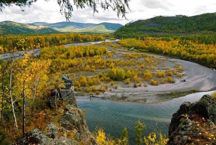
Transbaikalia is a taiga region. The combination of a harsh climate with beauty mountain taiga , blooming steppes , green meadows, intermountain depressions , unique landscapes of snow-covered mountains against the background of the always high blue sky, with an abundance mountain rivers and blue lakes creates an unusually attractive natural environment. Everything that Russia is rich with is here: hard-to-reach taiga and dull marshy mars, mountains with glaciers and steppes with the richest herbs, mountain rivers and picturesque lakes, unique mineral springs .
In terms of the number of mineral springs, the Chita region is ahead of many regions of Russia. Their abundance is associated with the peculiarities of the geological structure and the activity of endogenous processes occurring in the region. On the base 7 sources operate resorts: Darasun, Kuka, Molokovka, Shivanda, Yamarovka, Yamkun, Urguchan .
Mineral resource base Chita region is unique. In the Kalarsky district in the north of the region, several deposits of a global scale are concentrated on a relatively small area: almost all of them are the largest in the world. Here about 300 deposits have been taken into account, 18 have been explored.
Half of the Trans-Baikal relief is occupied the mountains over 1000 meters high. There are practically no lowlands on the map of the region, but there are rolling fertile plains . mountain ranges Transbaikal people call hills , a intermountain valleys padami . The peaks and slopes of the ridges are occupied by cedar. Trans-Baikal birch grows on the edges of the forest. Majestic apple ridge , which in translation from Buryat means "pass", rises with its spurs to a huge plain, in which, like in a saucer, the regional center of Chita with its environs and suburbs is located.
- Let others interpret, chi is that, chi is not that?
Just whatever happens to me
I am firmly convinced that Chita is the one
With whom my heart has long been related.
There are famous cities on the planet,
Cities - anywhere.
Let the years pass
Like your waves, Ingoda.
Only I can’t get away from Chita anywhere.
Never ever.
Like the dawn over Russia, she is young.
As the wife of a Decembrist, she is proud.
We are familiar with Chita - how many winters, how many years!
Will I go to the east, to the west, -
Everything will seem to me: comes after
Bagul has a strong smell.
I do not believe the oaths that are given in the heat of the moment,
Cities are not easy to get used to.
Just how to forget those friends that met
At Chita native crossroads?
Y. Goldman "Song of Chita"
Chitinka is the Chita River. A diminutive nickname for this left tributary of the Ingoda was given by local residents. In its waters dwell taimen, lenok, grayling, burbot, minnow, gudgeon . In the spring it sets Amur ide , lovingly called "chebachok" by local fishermen. There is a kind of small spotted catfish , sometimes comes across gubar horse related to the ichthyofauna of China.
cool places
For the majority of residents of the European part of Russia "Transbaikalia" sounds almost like "Through the Looking Glass"- the country is incomprehensible, and by and large, unknown. marvelous rivers, rivers, rivulets-sidewalls, keys this region is known, and all of them have their own characters. Either their waters are quiet and soft, or they ring iridescently with their crystal jets, or they rush with some kind of frenzy, stubborn and fearless, or they lure with their charm, mystery. Vitim, Ingoda, Onon, Shilka, Argun, Olenyok, Selenga, Khilok, Chikoy, Menza All of them cannot be counted, because they have no number.For the fishermen of Transbaikalia, the word Chikoy sounds like an alarm. Still would! There are found taimen, lenok, burbot, grayling, whitefish
, many other equally attractive fish. And fishing in the wilderness, from the ice, on the deserted upper reaches of the Chikoy, fabulously rich in animals and fish, is a special conversation about this in general ... Chikoy takes his start on southeast Chita region, not far from the Mongolian border, near the Burun-Shibertui char, considered the crown of the Chikoi Highlands, and, gaining strength, “It rushes with a roar among stones, stunted dwarf birch and mosses, hurries to treat distant Baikal with melted snow”, as a Chita resident wrote about her Nikolay Yankov
. In the upper reaches, the river bends, bends around the spurs of the Malkhan Range from the south, near the village of Baikhor, Krasnochikoysky District, the legendary Menza joins it, which in turn is replenished with water from the fabulously fishy side river Burkel. Then the channel of the Chikoya passes on the border with Mongolia and near the Buryat village Bolshoi Kudar turns to the north-west to join the waters of the Selenga south of Novoselenginsk.
The dream of every angler in the Chita region is to go fishing in the upper reaches of the Chikoya, which is conditionally divided into crowded and deserted. In the first case, this refers to the section of the right bank, where typically Transbaikalian settlements are located - Menza, Baikhor, Krasny Chikoi, Cheremkhovo, Bolshakovka, Zakharovka, Osinovka, Shimbelik, Ust-Yamarovka and others; in the second, it is customary to count the deserted upper reaches of the Chikoi from the Povarnya settlement, which is 4 km southeast of Yadrikhin, the last inhabited settlement adjacent to the river. From here begins the real, complete desertion - no barking of a dog, no crow of a rooster, - a ringing silence.
Among the regulars of river pits and reaches, only they understand expressions: “Yesterday we were at the “pipe” in the morning - empty”. Or: “We drove to Ugdan, then to Brooks - nothing, but on Avdey I took it well“ on top ”. Expressions "Streams" or "Avdey" is geographic links to the river, and here "above" or "below" - clean fishing terminology. "Above" - refers to all types of riding gear and lures. "Ship" , which is called here "sleigh", equipped with dry riding or wet plunging flies. Or pseudo-fly fishing, that is, a rod that has a reel in its mood, a heavy float - a “carrot” and four or five riding flies. Sometimes this tackle is simplified. The “carrot” is removed, and only one dry “fly” is left. They catch such tackle “on top” or slightly sinking the bait.
Transbaikal nature
Almost a third of the area is occupied icy northern ranges. The vertex of one of them (in b> ridge Kodar) reaches 3072 m.Zone permafrost, glacial lakes, extinct volcanoes, canyon-like valleys, deep gorges, peat bogs, swamps and mari, sharp peaks of ridges covered with dark larch forest- all this creates a magnificent, original flavor of the Trans-Baikal north.
The varied topography gives rise to different rivers. Flowing among the ridges - swift and abounding rapids and rifts. Calm rivers flow in the valleys, such as the muddy yellow Argun , or shipping Shilka . Many rivers turn into roads in winter, or "winter roads", as they are called by the Transbaikalians. In the remote taiga northern villages, except by helicopter, it is possible to deliver goods only through freezing Tungira and Olekmy .
The fauna of the Chita region includes 500 kinds vertebrates, of which more than 80 mammals . The area is rich commercial fur animal (about 25 species): wolverine, red and black-brown fox, corsac fox, badger, muskrat, hare, otter. Among ungulates ranks first in number roe, then - wild boar, elk, red deer. World feathered has more than 350 types. Found in the forests black grouse, capercaillie, hazel grouse. On the lakes mallards, divers, mergansers, geese, gray swans. In the Trans-Baikal reservoirs more than 60 types fish . A delicacy lives in the northern lakes whitefish.
On the territory of the region about 15 thousand lakes.
In 1994, in the border areas of the Chita region, a international reserve "Dauria". Being almost in the center of the Daurian steppe ecoregion included by the World Fund wildlife among the 200 ecoregions of the world, globally significant for the preservation of life on Earth, the international reserve has become a leading center for the study and conservation of the nature of Dauria. This corner of Asia is filled with a unique smell Daurian steppe - the cradle of nomads and the homeland of the formidable Genghis Khan.
Dauria - historical, geographical area in Eastern Transbaikalia and partly in Amur region. The Daurian Land was the Russian name for the Amur region in the 17th century; after the 17th century, the name Dauria was preserved in the physical geography of Transbaikalia. Baikal Dauria occupies the territory from Lake Baikal to apple ridge, Nerchinsk Dauria located east of apple ridge, a Selenga Dauria - in the pool Selenga rivers. The name Dauria comes from the name of the people dauri, or dahurs, who lived in the 17th century in Eastern Transbaikalia and along the Amur. It is believed that the Daurs are Mongolized Tungus. The first news about daurs appeared in Russian sources in 1641: “up the Vitim and up to the Yarovna (Eravna) lake on both sides of the Vitim river, many Daurian horsemen ...”
Pine forest in the Onon district of Tsirik-Narasun declared a natural monument
Flora Reserve "Dauria" is a species diversity of plants. Here they are known about 1800 species. Over 70% of the region's forests are larch. It is both the main building material and the main decoration of the landscape. The pine forest in the Onon district of Tsirik-Narasun (translated from Buryat as “pine army”) has been declared a natural monument. These pines are 400 years old. Dauria meets with the joyful blue of its skies, the gentle outlines of the mountains and the colorful blanket of their steppe and meadow grasses. Beneath the ledge of the high terrace river Nerchi hiding a small elm grove from elm squat. Ilms in Dauria are relics eras with milder climates. Under the canopy of elms there are many species herbs . Lots of polynya. Such a number of red book Venus slippers, how in Gazimur-Budyumkan Dauria , is not found anywhere. Even in the reserves of Primorsky Krai there is no such abundance of venus slippers.It is in this reserve that especially significant or key nesting and stopping places during migration of more than 20 species birds included in the IUCN Red List as globally vulnerable. In general, in Dauria, there are several tens of millions of birds of more than 350 species on migration. The Daurian Ecoregion is also of key importance for the conservation gazelle- the only wild antelope in northeast Asia, more than 90% of the population of which also lives here. In Dauria, large steppe areas are well preserved, densely dotted with many lakes of different sizes.
Priargunye is a unique and mysterious country in its nature, located on southeast Chita region. Main water artery territory - border with China (740 km) Argun river with tributaries of the Urulyungui, Srednyaya Borzya, Kalga, Urov, Uryumkan and Gazimur . Argun originates in Manchuria, where it is called Hailar. In the middle reaches, the floodplain of the river reaches two or three kilometers, and the river itself is divided into numerous branches, separated by many islands, overgrown with willow and tall grass. In summer, a lot of waterfowl live here. Below the Urov River, the Argun valley is a wide forest lowland. And only near the mouth, the spurs of the Khingan from the south and the spurs of the Nerchi Range from the north compress the channel of the Argun, and it flows in steep steep banks. In the valley of the Urulyungui River at the mouth of Khirkhira, not far from Ust-Tasurkay village the ruins are located Khirkhirinsky ancient Mongolian city- the military-administrative center, the residence of the Mongolian feudal lord, the noble ruler of Genghisid Jochi-Kasar. A road runs through the territory of the city, running along the left bank of the Urulyungui. The city is made up of the remains of a palace, a number of fortified estates of the nobility, representatives of the aristocracy, and many ruins of the houses of ordinary citizens - artisans and merchants. During the excavation of a palace covered with gray tiles and a floor lined with gray bricks, dishes of ancient Mongolian origin were found, similar to the dishes of the Karakorum - the headquarters of the Mongol feudal lords. The disks of the upper tiles of the roof are decorated with a relief pattern resembling a beetle.
In the old days Argun horse Cossacks of the villages of Duroy, Kailasutuya and Abagaytuya , according to old-timers, recorded in 1876 by one of the visiting merchants "lived happily ever after". They were doing arable farming and animal husbandry, bred bees. The poorest Cossack had at least ten heads of cattle, but Argun was the main breadwinner. There was plenty of fish that was speared, however, as were birds. The fish was taken to the surrounding villages to foot Cossacks or to the Nerchinsk and Aleksandrovsky Plants and exchanged for bread and goods at a great profit.
The village of Old Tsurukhaytuy is called the most beautiful and one of the oldest Russian villages not only in the Priargunsky region, but also in the entire Eastern Transbaikalia
Majority Priargunya village - vintage. Their names also attract with their mystery and unusualness: Byrka, Zorgol, Mankechur, Dosatui, Nickname other. Each of them has its own rich history, for example Nickname. In 1828, the Decembrist Ivan Sukhinov, exiled to Gorny Zerentui, tried to organize a conspiracy involving prisoners from the prison at the Klichka mine. The plot was uncovered because a traitor was among the rebels. Located on the Argun River, the border Old Tsurukhaytuy village is called the most beautiful and one of the oldest Russian villages not only in the Priargunsky region, but also in the entire Eastern Transbaikalia. It was founded as a border guard by Savva Raguzinsky, who concluded the Burin Treaty with China in 1728. In the summer of the same year, the border commissioner Burtsev signed a treaty with the Chinese side on the election of Tsuruhaituya as a place for border trading. Tsuruhaitui translated from the local language means "pike place". The village was named so because in the old days Argun, washing the picturesque high bank of the village, was unusually rich in fish.
In the territory Kalarsky district is one of the attractions Chara basin sand massif Chara Sands, stretching from the southwest to the northeast in the direction of the prevailing winds for 10.5 km with a width of up to 4 km. There are no such large accumulations of free-flowing moving sands in any basin of Transbaikalia.
Here, in the Kalar region, in a small intermountain depression, the Chepe volcano is located. The extinct volcanoes of Udokan were discovered by the Irkutsk geologist V.P. Solonenko in 1961. At the foot of Chepe volcano there are exits mineral springs , of which the most interesting Golden Cascade . Its waters, flowing down a stepped channel, lay a bright golden-yellow ocher. In some places, the thickness of its layers reaches 1 m. On a sunny day, the water of the spring, flowing down the ocher bed, creates the impression of a golden cascade.
In the territory Chita region, in valley of the Chita river located Avdeysky Bulgunnyakh. Bulgunnyakh is the Yakut name for large swelling mounds - hydrolaccoliths, which arise when lake basins with descent or peat-filled lakes freeze, located in closed depressions in areas of permafrost development. The core of the hydrolaccolith consists of frozen ground interlayered with ice, 45 m high and 100 m in diameter at the base.
On the left bank of the Dai River, in 2 km from Shivia-Daya highway located the only thing on Russian territory locality of remains of various Early Cretaceous insects (linceuses, shields, anostraci ) unique preservation. Among them are representatives of the biota of ephemeral reservoirs. Various deposits are exposed in the coastal cliff.
Within Aginsky-Buryatsky district on the Borshchovochny Ridge Golets Alkhanai is located. He is ancient stratovolcano . Its height is 1663 m. There are many interesting forms of weathering here, among which the rocky outcrop in the form of a gate is especially famous. The loach has an exit cold mineral springs dimchik god and nine gutters.
Sokhondinsky Nature Reserve is the standard of the unique nature of Southern Transbaikalia
Sokhondinsky Reserve- the pearl of the Trans-Baikal Territory. It is located in the south of the Chita region and is the standard of the unique nature of Southern Transbaikalia. The uniqueness of the reserve, first of all, in diversity his landscapes . Here, on a relatively small area, typical for Transbaikalia are concentrated steppe, taiga, mountain-tundra, transzonal (meadows, swamps, lakes, etc.) communities. The surroundings of the reserve are busy steppe areas . When climbing mountains, various types forests replace each other. Birch, pine, larch, fir, Siberian cedar and cedar elfin form the diversity of the forest belt. There are 135 species here. lichens.The highest altitude above sea level is reached loaches Greater Seohondo (2,505 m) and Small Seohondo (2404 m). The name of the loach and the reserve probably comes from Evenki or Buryat languages in which the words "soho" or "choco" matter "top, head". Therefore, it is not surprising that highest peak in this mountain range received such a name. The snow that falls in winter melts slowly, so in the mountains even in the second half of summer you can find unmelted white fields - snowfields. Here, in the highlands, traces of the activity of former glaciers are clearly visible: moraine ridges (accumulations of loose material accumulated by glaciers during their movement and plowing of the bed), kars (or "circuses" - bowl-shaped depressions in the upper part of the mountains (above the snow line), formed under influence of glaciers, snowfields and frosty weathering), lakes of glacial origin.
especially picturesque Bakukun Lake , which became « calling card» reserve. It is located at an altitude of 1892 m above sea level. Over the shores of the lake hang steep, devoid of vegetation, the walls of the car, once formed by a glacier. The height of the walls is more than 500 m. The lake, like a dam, is dammed by a moraine shaft. In the icy waters of Bakukun Lake lives lenok. It is rare for a typical river fish to settle in a lake.
Vegetation and animal world The reserve is extremely diverse. This is primarily due to the mountainous terrain of the territory, due to which here at a small distance from each other can be met steppe, forest and alpine plant species and animals. In the Sokhondinsky Reserve you can meet many alpine plants. Among them, a significant part is made up of picturesque, flowering species, which give special beauty to the alpine lawns of the subalpine and bald mountains.
Sokhondo is a reference area of the southern Siberian taiga, the biodiversity of which is practically not affected by humans
At first glance, the fauna of the Sokhondinsky Reserve does not stand out for something special. For example, many animals common in Transbaikalia are protected on its territory: fox, sable, ermine, weasel, brown bear, Siberian roe deer, Siberian musk deer, wild boar, squirrel, hare, capercaillie, hazel grouse, nutcracker. However, the uniqueness of this place is that Sokhondo is one of the few reference sites of the southern Siberian taiga, the biodiversity of which is practically not affected by humans. It is no coincidence that in 1985 the reserve received the status biospheric (UNESCO Biosphere Reserve
), which emphasizes the importance of the territory for the conservation and study of the state of the biosphere of our planet as a whole.
In addition, the importance of the Sokhondinsky taiga lies in the fact that many Transbaikal rivers. Passes through the reserve section of the Great Divide, on which the rivers belonging to Pacific and Arctic Oceans: Ingoda, tributaries of the Onon
and Chikoya
.
923 species and subspecies were noted on the territory of the reserve and its environs. higher vascular plants
, 8 kinds fish
, 3 — amphibian
, 4 — reptiles
, 257 kinds birds
and 67 species mammals
. Over 2300 species have also been registered insects
and arachnids
.
In the nature reserve taken under guard
71 species of plants, fungi and lichens, 10 species of mammals, 36 species of birds and 17 species of insects, listed in the Red Book of the Chita region and Aginsky Buryat Autonomous Okrug, 29 species of mammals and birds (including white-tailed eagle, white-tailed crane , black demoiselle crane, black stork, kloktun, greater spotted eagle, imperial eagle, golden eagle, saker falcon, peregrine falcon, eagle owl) are protected at the international or all-Russian level.
Transbaikalia - an unknown land
European civilization learned about Transbaikalia only in the second half of the 17th century. Everything that lay beyond the Urals, Russian Europeans called Eastern Tatarstan. From here, from the river Onon, began the great conquest of Genghis Khan in Europe. In 1650, a detachment of Cossacks led by Yerofei Khabarov, moving against the flow of the Olekma and Tungir, reached places slightly below the confluence of the Argun and Shilka rivers. The Russians called the unknown country Dauria by the name of the tribes that have lived here for a long time daurs . In the autumn of 1653, the leader of the Cossack detachment Pyotr Beketov, sent from Yeniseisk with the Tsar's decree, built the Irgensky and Nerchinsk prisons here. Thus, Russian statehood was established in Eastern Transbaikalia, and the vast region became part of Great Russia. By the beginning of the 19th century, the Dahurian land was already quite inhabited, and its borders were more extensive. In 1851, by the Highest Decree of Emperor Nicholas I, the Trans-Baikal Region was created, and the town of Chita was elevated to the status of a regional city. In 1918, after the establishment of Soviet power, the region was renamed the Trans-Baikal Governorate. In 1920, the Far Eastern Republic was formed with Chita as its capital. Since 1922, the territory of Eastern Transbaikalia has changed its status. Its new history began on September 26, 1937, when the Chita Region was established as part of the RSFSR by the Decree of the Central Executive Committee.The first geographical ideas about Transbaikalia Europeans received from travelers who visited Central Asia in the 7th-15th centuries. The Europeans needed to know what danger threatens them from the east. The colonization of Siberia in the 16th-17th centuries enriched country studies with knowledge about peoples and their settlement, about natural resources, about communication routes and obstacles on them, about settlement conditions, and much more. Information about the areas of new settlement in Transbaikalia was concentrated in the Yenisei, Yakut and Nerchinsk governors, as well as in the Siberian order in Moscow. The pinnacle of the geography of East Asia was the work of N. G. Spafariy, the ambassador to China, later published in the book “Siberia and China”.
Spafarius (Milescu) Nikolai Gavrilovich (1635-1709) Russian diplomat . “The book, and it contains a journey through the kingdom of Siberia from the city of Tobolsk and to the turn of the Chinese summer 7183, the Mayan month on the 3rd day. And this book was written when, by decree of the great sovereign, tsar and grand duke Alexei Mikhailovich, all the Great and Small and White autocrats of Russia, Nikolai Spafary was released from Moscow to the Chinese state.. This was the name of the book of the Moldavian writer Nikolai Milescu (Spa-faria), a traveler, scientist, who accepted Russian citizenship in 1673, in the "Article List" called by the Russian name Nikolai Gavrilovich. In 1675-1678, Spafari carried out a diplomatic mission in China as an envoy of the Russian Tsar. Spafaria's embassy consisted of 150 people. The guides were local Cossacks who knew the way well. The ambassador described in detail the areas, rivers, rivulets, occupations of people ( “they hunt sables and there are no better sables”), prisons encountered on the way. “... We drove through the great and forest ridges, and then through the steppe, and arrived at the small Chita River and spent the night by that river. And the Chita River flows out of the stone mountains and flows into the Ingoda River ... "
Comprehensive study of the population of Transbaikalia and environment were engaged expeditions of 1768-1772 by Peter Pallas and Georgi organized by the Academy of Sciences. At this time, they were first organized meteorological observations in the Nerchinsk plant, geodetic surveys, collection of the most extensive collections of rocks and minerals, plants and animals, household and religious items, handwritten documents, the first dictionaries were compiled. In the middle of the 19th century, the General Staff began to join geographical research (the Trans-Baikal Expedition, 1849-1952). Together with the Geographical Society in 1855-1859. he mapped the vast territories of Transbaikalia and Far East. Participation in the expedition of the naturalist G. I. Radde and other scientists gave it a complex character. G. I. Radde was the first to describe the altitudinal zonality in the mountains. "Map of the Trans-Baikal region of the Kyakhta city administration" compiled in 1855 Colonel A. I. Zaborinsky , reflected ideas about the position of rivers, lakes, mountain peaks, roads, settlements etc. in relation to parallels and meridians.
Buryats - one of the largest ethnic groups inhabiting the territory of Transbaikalia. The formation of the Buryat people as a whole can be represented as a result of the development and unification of diverse ethnic groups that have been living in the Baikal region for a long time. The first groups of Mongol-speaking tribes in this region appeared in the 11th century. The tribes moved freely from Baikal to the Gobi desert. Only with the establishment of the Russian-Chinese border in 1727 did this movement stop, and conditions appeared for the formation of the Buryat people. Many researchers agree that the process of formation and consolidation of the Buryat people began in the 17th century. This is confirmed by archaeological and ethnographic data, according to which it is established that by the XVII-XVIII centuries. most of the indigenous tribes of the Baikal region became part of the formed nationality - the Buryats. According to the very first known Buryat chronicles "Balzhan khatanay tukhay durdalga" in 1648, the Buryats agreed to accept the citizenship of the Russian state.
Tungus ( self-names - Evenks, Orochons) constitute the most representative ethnic community among the small peoples of Siberia and the Far East. The zone of their settlement occupies a gigantic territory from the left bank of the Yenisei River in the west to the Pacific Ocean in the east. The Evenks speak local dialects of the Evenki language, which belongs to the Tungus-Manchu group of the Altaic language family. At the beginning of the 20th century, many Evenks in the south of Transbaikalia already called themselves Buryats, considering Buryat their native language. In contrast to the southern regions, in the north of Transbaikalia, the aboriginal population was more isolated from Russian and Buryat influence, which led to the preservation of cultural continuity. For the Kalar and Tungiro-Olekma groups of the Evenks, hunting and reindeer herding remained traditional forms of management. In contrast to the Tungo-Kochen and Bauntovskys, located to the south, who were partially employed in gold mining, the Evenks of the north of Transbaikalia retained traditional forms of management.
Edge of contrasts
Transbaikalia is a unique land of amazing contrasts and surprises. Is here and Rocky Mountains, and powerful ridges, overgrown on the slopes with magnificent Siberian taiga, and endless feather grass steppes. Greatness and wealth vast Russia especially noticeable among these endless expanses and the boundless sea taiga spread out under the ever blue sky. not without reason Anton Pavlovich Chekhov , passing through Transbaikalia, in their travel notes wrote: “... in Transbaikalia, I found everything I wanted: the Caucasus, and the Psla valley, and the Zvenigorod district, and the Don. During the day you ride across the Caucasus, at night along the Don steppe, and in the morning you wake up from your slumber, looking - already the Poltava province - and so on for a thousand miles. Transbaikalia is great. This is a mixture of Switzerland, Don and Finland. Generally speaking, Siberian poetry begins from Baikal, but before Baikal there was prose.. These words perfectly express the impression of Transbaikalia as a collective image of Russia. Here all her natural map was connected.There is an amazing place north of the Trans-Baikal Territory. The mountains. Taiga. Eternal Frost. And ... an island of the desert. Yellow sand dunes. They move inexorably along the Charskaya valley, crushing the forest under them. There are real oases in this desert with lakes with clear water, the banks of which are overgrown with trees. Where did the desert come from among the mountains and taiga? Here's how he talks about it legend .
- “That spring, Kodar woke up hard, painfully, During the day he would throw off his fur coat, warm himself under the May sun, and at night the northern blizzards would fly in, again whiten the tops of the mountains. And again Kodar plunges into his blissful sleep. And only in the middle of the month, when mountain rivers rushed through the gorges with a wild roar, on the slopes of the ridges a bagul flared up with a pink fire and a snowdrop turned blue, he finally woke up. At this time, a storm was born in the south of Mongolia in the Gobi desert. A sandy cloud rose up into the sky along black cords of whirlwinds, and the wind drove it to the north. The sun went out. Everything sank into darkness. A cloud floated like an ominous shadow over the steppes of Transbaikalia ... But on the threshold of the northern land, it hit its chest against the stone peaks of the loaches, howled from wounds and woke up on the ground like a sandy rain. The sun rose over the mountains. Old man Kodar looked around... Together with the morning rays of the sun from the Charskaya valley, Kodar heard the song of the Bird. Her voice was of amazing beauty. It seemed that the sky itself made magical sounds ... Now all the inhabitants of the mountains looked forward to every morning. With the rising of the sun, joy came to the northern land. Meanwhile, the forest thickened. Belt-high grasses rose in the valleys, mute deafness enveloped the mountains. There was anguish in Bird's voice. Now, when she sang, everything around was immersed in sadness. This hopeless longing echoed with pain in Kodar's heart. And he asked: "Tell me, Bird, what are you crying about?" “I was born and raised in the Gobi desert,” the Bird answered him. — The storm threw me into the sky and brought me here, to the taiga region. I cry about the desert, about my homeland. "What good have you found in the barren sandy land?" Kodar was surprised. “You don’t choose your homeland and mother,” the Bird replied. “Great old man, I beg you, show me the way to my native land.” "You will return to your homeland, but only in autumn, with caravans of swans." Kodar waved his hand, and a strip of real desert ran through the Chara Valley. Lakes turned blue between the dunes, pine trees rose on their banks. The Bird sank down on a sandy ridge, and joy resounded in her voice again.
Ridge Kodar - "stone wall", "rock"(translated from Evenki), which contains highest point edge of the BAM peak, reminiscent of the Alps. And the Udokan ridge, what does it mean "shaman", can be compared with a fantastic alien world: “... wild mountain peaks, volcano cones, gloomy gorges, endless stone placers, mineral springs brightly colored with red, yellow and orange deposits ... There are many legends about these two ridges. There is also such an old Evenki legend. Two fabulous giants Kodar and Udokan found a rich treasure in the ground and argued, but could not agree on who should own it. Then they pulled tight bows and shot arrows at each other. Both dropped dead. High mountains reared up in this place and buried that rich treasure under them ... "
The Kodar glaciers are the only modern mountain glaciers within the Stanovoy Upland. Small hanging and cirque glaciers add to the uniqueness of the landscape, adding to the contrasts of the area's landscapes. Among the six main glaciers located near the highest mark of Kodar (3073m), stands out glacier them. E. Timasheva . In its snow-white center there is a deep well, into which a waterfall falls down a crack, fed by a lake on a glacier. The Kodar glacier group gives rise to the rivers of the Upper and Middle Sokukan . The Kodar Ridge limits the Chara Basin along a tectonic scarp, clearly expressed in the relief. The depth of the dissection of the relief reaches 2000 m, many hundred-meter sections are rocky walls with a slope of 70-80 degrees. Traces of ancient glaciation are well preserved here: many elongated valleys up to 1000-2000 m wide, partitioned off by high ledges - crossbars. In their upper part there are fields of “curly” rocks, in the middle and lower parts there are moraine deposits. Large tributaries of the Chara, cutting through the crossbars, form narrow rocky corridors in them. All this gives the area an unusually picturesque flavor.
Originally from Transbaikalia
- Painfully familiar landscape
And the heart of the native vernissage.
Birches and pines stand
Enchanting and pleasing to the eye
In the paintings of Yuri Kuznetsov, forest rivers and streams flow, bird cherry blossoms, a birch leans over the river, amber sunsets captivate the eye, wild rosemary blazes with fire, it is raining and autumn enchants us with a fairy tale, and March snow, and all in the rays of the sun a summer landscape and a cold winter drawing .
See all the seasons, get from winter to summer, walk in the warm rain, wander along the paths in the birch forest
Yuri Petrovich was born in Chita in 1924. Two wars fell on his youth at once - with Japan and with Germany. When the long-awaited peace reigned, he was able to fulfill his dream by enrolling in the Irkutsk Art College. In 1950, a young teacher of drawing and drawing, Yuri Kuznetsov, appeared at the Chita school No. 1. He worked here for nearly 30 years. When he retired, there was more time for drawing. Paintings, drawings, landscapes and even woodcarving and casting of artistic engravings. In the paintings, the image of the native land, the bridge over the river, the sunset on the lake. See all the seasons at once, get from winter to summer, walk under the warm rain and wander along the paths in the birch forest. Such an opportunity opens up at exhibitions of paintings by Yuri Kuznetsov.
From the canvases of this artist, where we see the slender camps of thin and dear birches, glades lit by the sun and the gold of the grass, some kind of touching silence and slight sadness emanates. We see the enchanting region of Transbaikalia with the coolness and depth of the rivers and the chic spreading crowns of huge centuries-old pines. In the paintings of the Chita artist Yuri Kuznetsov, one can see such a familiar, but never repeated landscape, although birch and pine trees are present on almost all of his canvases.
- Golden autumn blinds us
And the clouds in the fog are melting.
Ledum is burning with flame,
The birch speaks with soul.
Roads, pines and paths,
Glades, thin blades of grass.
Captivated by rivers and forests,
Nature's wonderful beauty!
Homes that are painfully familiar.
To walk again through the forest, the field,
Where there is peace and quiet
The soul of the artist is visible.
Art is the transmission of beauty, grace and culture
touches the soul and "Rural landscape" , painted by an artist between Darasun and st. New, where a motley herd of cows scattered serenely in silence across the field. And this is one of more than 200 paintings he painted during his career in recent years. All the walls of the small apartment of the artist, who lives in Pine Forest, are decorated with landscapes, among which there are several portraits and graphics. Lovely pictures! According to Yuri Kuznetsov himself, he loves to paint beauty and everything that makes sense. Art is the transmission of beauty, grace and culture. And these words of his are confirmed by the entire creative life of the artist and his amazing paintings. But not only the artist himself admires this beauty. How many solo exhibitions were in his life, and all of them are dedicated to native land Transbaikalia! How many wonderful moments and how many wonderful feelings many experienced from contemplating his paintings! How much inspiration and skill on these canvases that can decorate more than one art gallery! The artist is known not only in Chita, his works are also abroad in private collections in Germany, Israel, Egypt.
- April snow, houses and gardens
And March dark water,
The coolness of Ingoda, the waters are transparent,
Nikishiha, what a wonderful dream!
Snowdrop, like the beginning of spring,
Ledum is on fire.
You have never seen such beauty
Where the forest so fabulously beckons.
Before a thunderstorm, the trees bend with the wind,
Clouds darken in the sky.
Even the pine had to bend
With its crown slightly.
Houses in the forest and the pine trunk turns black,
And next to it are golden birches.
And there is no dearer land for us,
The soul is moved to tears.
The road leads us to the village
And bushes, path, house.
There is a birch-touchy
In a chic gold dress.
The whole world is a beautiful nature,
What is so exciting to the depths.
as a heritage of the people
The entire exhibition of his paintings!
Yuri Knyazkin is the man whose name the stars are called. He devoted his whole life creation of space satellites. He is currently Deputy General Designer for electrical design of spacecraft, their operation and flight control JSC "Information satellite systems named after Academician Reshetnikov" . In 1953, immediately after graduating from the secondary Chita male school No. 5, silver medalist Yura Knyazkin went to enter the capital at the Moscow Aviation Institute. After graduating from high school, he moved to Zheleznogorsk. There, in the scientific and production association of applied mechanics, he began working as a simple engineer. And now the whole country uses the works of Yuri Knyazkin - for example, cellular and roaming are available to everyone, thanks to satellites developed by the research and production association. And at the beginning of 2009, the company's specialists launched a new satellite - Express-44. He became one of the first satellites that are necessary for the development of a digital television network in Russia. It allows you to transmit a much larger number of channels in much better quality. Sending creations of design thought into orbit, Yuri Mikhailovich Knyazkin always remembers that somewhere out there, in space, there is a star named after him.
Oleg Leonidovich Lundstrem, outstanding Russian jazz musician , was born in 1916 in Chita. In 1921 his family moved to Harbin (Manchuria, China). Father, Leonid Frantsevich Lundstrem, was invited to work, first as a physics teacher in a secondary school, and later as a lecturer at the Harbin Polytechnic Institute. In 1932, Oleg graduated from a commercial school and entered Polytechnical Institute, and in parallel to the music technical school, which he graduated in violin in 1935. In the early 1930s, everyone was carried away by a new dance - foxtrot and, accordingly, new music - jazz. At first, this rhythmic calm music did not attract much attention of Oleg, until by chance (in 1933), while picking up records for the next party, he came across a record of the Duke Ellington Orchestra, completely unknown at that time. The play was called Dear Old South. She stunned Oleg, and he immediately realized that this music was not only for the legs, but something more. She made the same impression on his friends, young musicians who had already begun to join jazz. In the same way they attacked the trail of Louis Armstrong, and from that moment the passion for jazz began. Little by little they played music, began to play at dances. And Oleg inquisitively studied the sound of the orchestra and began to arrange and reproduce plays from records by ear.
The press called Oleg Lundstrem the "King of Jazz of the Far East"
In 1934, young musicians decided to assemble their own jazz orchestra and Oleg Lundstrem was chosen as the leader. The orchestra consisted of nine musicians: two alto saxophones, one tenor saxophone, two trumpets, one trombone, piano, banjo and double bass, and drums. That was the composition of the big band then. 1935 - the year of gaining popularity in Harbin. The orchestra played at balls, evenings and performed on local radio. In 1936, the orchestra moved to Shanghai (now China) - a huge international port center, where its professional activities began. Subsequently, Oleg came up with the idea that it is possible to perform our Russian songs in a jazz arrangement. He makes arrangements "Song of the Captain" by I. Dunayevsky, "Foreign Cities" by A. Vertinsky, "Katyusha" by M. Blanter other. All of them enjoy constant success with listeners. The peak of popularity came in 1940. There are already 14 people in the orchestra, where Oleg is conductor . The orchestra becomes one of the best in Shanghai. The press called Oleg Lundstrem the "King of Jazz of the Far East". After the end of the Second World War, Oleg wrote his first independent work "Interlude" , using Rachmaninov's intonations, later - play "Mirage" to oriental motifs.
In 1947, the full orchestra with their families moved to the USSR, to the city of Kazan. The musicians wanted to get an education at the conservatory. Initially, they decide to make the orchestra that arrived a jazz group of the TASSR, but the decision of the Central Committee of the CPSU on Vano Muradeli's opera "October" in 1948 breaks everything. It turns out that people don't need jazz. And the musicians are distributed to the opera house, to the orchestras of cinemas. Oleg enters the Opera and Ballet Theater as a violinist. However, the orchestra did not break up thanks to the composer A. S. Klyucharev, who immediately assessed the possibilities of the orchestra that arrived in Kazan. Oleg began to make adaptations of Tatar songs and the most popular Soviet songs. In 1955, the orchestra recorded on the radio and on gramophone records a whole series of plays by Tatar composers, arranged for jazz by Oleg Lundstrem, and gave a series of concerts that were a great success and attracted the attention of Moscow concert organizations.
In 1956, a large tour and concert life of the orchestra began. For almost 40 years, the team has traveled to more than 300 cities in Russia and dozens abroad. The creed of the orchestra: a deep insight into the nature of jazz performance, its classical traditions and the desire to contribute to this genre by creating and performing original jazz works and arrangements. Oleg Leonidovich Lundstrem in 1973 was awarded the title Honored Artist of the RSFSR , in 1984 - People's Artist of the RSFSR , in 1993 - Honorary Degree of Doctor of Science from the International Academy of San Marino .
If you are lucky enough to visit the hospitable, hospitable, hospitable Chita region, do not get tired of admiring the exceptional beauty of this region and notice that here: the most a large number of healing arshans; the largest and most famous reserve Sokhondinsky; the most majestic river is the Onon; the most beautiful taiga, knowing no borders or limits; the most delightful mountains, in a white haze of apricot blossoms; the most brilliant lakes under the sun, surrounded by tender irises, with white swans flying over them; the most boundless meadows in curly fiery lilies; the most berry padi and mushroom forests; the most loving people.
The Trans-Baikal Territory is famous for its marvelous nature and mineral springs, in terms of the number of which it ranks second after the Caucasus. Snow-capped mountain peaks, age-old taiga, clear lakes and mountain rivers delight and fascinate a person who first came to this land. The sky here is almost always clear and clear - in terms of the number of sunny days, the administrative center of Chita is even equated to Sochi.
The Trans-Baikal Territory is a territory where different peoples have left their centuries-old traces in the form of architectural and archaeological monuments, interesting customs, beliefs and rituals. There are many monuments of the Buryat national culture. You should definitely visit the Alkhanai National Park - the only place in Russia where natural attractions harmoniously coexist with the sacred objects of Buddhism.
List, photos with names and descriptions of attractions worth visiting!
1. Daursky Reserve
It is located in the south of Transbaikalia, on the border with Mongolia and China. Founded in 1987 to protect the steppe ecosystems of Dauria. The main object is the Torey Lakes, the largest in the region, a nesting and resting place on the migration of many birds, including very rare ones, for example, the relict gull. Only 6 species of cranes live here. Also, the reserve is the only habitat of the gazelle antelope in the country. Another attraction is the granite remnants of unusual forms of Adun-Chelon.
2. Butinsky Palace
The main attraction of Nerchinsk. It was erected in 1860-1870. Belonged to well-known merchants in the city, gold miners and philanthropists Butin. It was famous for its unique Venetian mirrors and a magnificent garden with tropical plants. In the courtyard of the estate, in addition to a chic medieval-style palace, there were water towers, warehouses, park areas, gazebos, and fountains. In the early 2000s, the building was restored and transferred to the local history museum.

3. Great source (Mount Pallas)
A small mountain of the Yablonevoy ridge with a height of 1236 m. A monument of nature. It serves as the beginning of the three largest rivers - the Amur, Lena, Yenisei. It is at this point, called the Great Source, that the basins of two oceans, three seas and three rivers meet. This discovery was made in the second half of the last century. The area attracts tourists with fresh air, endless expanses of water, larch taiga, high cliffs. In addition, the Great source is a place of religious pilgrimage.

4. Kodar National Park
Created in 2018 in the north of Transbaikalia. Area - 492 hectares. Mountain taiga forests along the banks of two rivers - Chara and Vitim, ecosystems of the Kodarsky mountain range, habitats of endangered animals, such as the bighorn sheep, historical and cultural objects are subject to protection. The famous Chara Sands, volcanoes, glaciers, 570 lakes, mineral springs, the Marble Gorge and other natural objects are located on the territory of the park. Tourist routes are being developed.

5. Chara Sands
Sandy desert with an area of 10 by 5 km in the middle of the taiga. It is located at the foot of the Kodar ridge, in the Chara basin. The dunes reach a height of 80 m, the length of the largest ones is up to 200 m. There are 2 lakes on the border of the sands. It is believed that the desert arose on the site of an ancient glacial lake, from which only small water fragments remained, scattered throughout the basin. It is located in a remote place, although the nearest village of Chara is 9 km away.

6. Glaciers of Kodar
Monument of nature. The only place of mountain icing in Transbaikalia. It is located 50 km from the village of Chara. main feature- a great distance from the sea and ocean coast. The total area of the ice massif is more than 6 thousand hectares. It was opened in 1958. About 40 glaciers have been discovered and studied, the largest have their own names. The surroundings are very picturesque and attract climbers not only from Russia, but also from other countries.

7. Alkhanay National Park
The main pearl of the park in the Aginsky Buryat district is the Alkhanai mountain range covered with forests. It is a monument of nature and at the same time one of the main Buddhist shrines. The objects of worship for pilgrims are stone figures and structures created by nature itself. Among them are the temple of the Great Good with healing water, the Temple of the Gate rock in the form of a 6-meter arch, the remnant of the Diamond Princess with a natural bowl, the cave "Mother's Womb" and others.

8. Assumption Church in Kalinino
The oldest building in Transbaikalia from the surviving buildings of the pre-revolutionary period. It was consecrated in 1712. It was built as the main temple of the male Assumption Monastery, which was subsequently simplified, and the church was turned into a parish. Built in the Moscow baroque style. In 1929 it was closed and ruined. Since 1970 it has been completely abandoned. There have been talks about restoration for a long time, but so far the building is more and more destroyed.

9. Lake Arey
Monument of nature. Area - 4 km 2, maximum depth- 13.5 m. It is famous for its healing air - it is surrounded by larch and coniferous forests. They are complemented by picturesque glades of "alpine meadows". Mud from the bottom of the lake has healing properties and is used by local health resorts to treat skin diseases. Areya water is saturated with oxygen, contains silver, iodine and other useful substances. There are many anthills on the coast. There are several sources.

10. Baikal-Amur Mainline
One of the largest railway lines in the world. Length - 4287 km. It starts in the city of Taishet, crosses 11 rivers, 7 mountain ranges, 60 settlements on its way and ends on the Pacific coast. Construction began before World War II and continued in 1974. The first trains along the BAM route passed in 1984. 10 tunnels were built along the entire route, the most difficult one was made in the North Muya Range. Its length is more than 15 km.

11. Kazan Cathedral in Chita
The main Orthodox church in the city was consecrated and opened in 2004, on the occasion of the 110th anniversary of the founding of the Trans-Baikal diocese. It was built on the central square, on the site of the former cathedral, destroyed in 1936. Made in the style of traditional church architecture of the XIV-XVI centuries. A majestic look is given by 5 light drums with bulbous domes. Can accommodate more than 2 thousand believers. It has a 60-meter bell tower, on which there are 13 bells.

12. Aginsky datsan
Located in the village of Amithasha. Date of foundation - 1811. Originally consisted of one main and four small temples. Then another building was added, and by the end of the century the datsan became the largest Buddhist monastery in Transbaikalia. He was famous for his library, medical, astrological and philosophical schools, he himself printed textbooks, dictionaries, ritual texts. In the 30s of the last century it was closed and plundered. In the early 1990s, it was re-consecrated.

13. Shumovsky Palace
The family nest of the gold miners of the Shumov brothers. The date of construction is 1914. The facade of the three-story mansion is painted pink, has white decorative columns, and is generously decorated with stucco molding in the form of floral ornaments, spirals, and animal muzzles. The roof is crowned with domes with spiers. The interior decoration is no less luxurious - marble floors everywhere, wall paintings, molding, forged metal gratings on the stairs. Today the palace houses the department of the FSB.

14. Chita datsan
The very first Buddhist temple in Chita. It was built over 8 years, was consecrated and opened in 2010. To decorate it, a 2-meter gilded Buddha statue, brass lions mounted on the sides of the main deity, and a sacrificial incense vessel were specially delivered from the Mongolian city of Ulan-Ude. Currently, services are held within the walls of the datsan - khurals, various rituals and ceremonies designed to help and protect from negative forces.

15. Heetei Caves
A monument of nature, consisting of two karst caves - Dry and Wet. The largest in Transbaikalia, the total length is 150-160 m. The wet cave is of the ice type, has 4 grottoes, the area of the largest is 70 by 60 m. To go down into it, you need to overcome a 12-meter icefall. The second cave - Dry or Summer - consists of a large funnel, at the bottom of which limestone blocks are located. It is advisable to visit the caves as part of excursions and with special equipment.

16. Chita Zoo
The first animals in the Pioneer Park of Chita appeared in 1986 through the efforts of the employees of the Palace of Pioneers. And the official opening date of the city zoo should be considered 1994. The number of its inhabitants is steadily growing. Today, 156 species of animals live here, about 700 individuals. Many have offspring, including exotic Alexandrian parrots, which rarely breed in captivity. Excursions are organized for visitors to the zoo.

17. Trans-Baikal Botanical Garden
The botanical garden in Chita covers an area of 2.8 hectares. It also includes a nursery with an area of 24 hectares in the village of Peschanka. Tropical, ornamental, woody, medicinal plants, collections of roses, irises, lilies, etc. are grown here. The assortment is constantly replenished through expeditions and the exchange of seeds with other botanical gardens. Educational excursions are conducted by the staff of the institution. Of particular interest is a visit to the greenhouse winter gardens.

18. Museum of the Decembrists
More than 70 Decembrists were in hard labor in the current city of Petrovsk-Zabaikalsky, from 1830 to 1839, the wives of 10 of them lived nearby. The museum was opened in 1980 in the surviving two-story mansion of Princess E. Trubetskoy. The expositions are located in 5 halls and acquaint visitors with the history of the Decembrist movement, as well as with the living conditions in which the exiled Decembrists lived. Among the exhibits are drawings, documents, books, household items.

19. Church of the Decembrists
The two-storied Archangel Michael Church is the oldest building in Chita, a monument of wooden church architecture. Date of foundation - 1776. In the 70s of the last century, it was transferred to the local history museum, since 1985 a museum of the Decembrists has been opened on its territory. Many of them visited this temple while in exile, some got married here. The museum contains more than 800 original exhibits, including personal items, books, letters from the Decembrists and their wives.

20. Lake Arahley
Among the largest lakes in Russia. It has a length of 11 km, a maximum depth of 20 m. The shores are very picturesque, covered with larch taiga with fragments of forest-steppe. There are sandy and sand and pebble beaches. It is famous throughout the region for its noble year-round fishing. The ichthyofauna is represented by 15 species of fish. It is believed that Arahlea fish is tastier and larger than the same in neighboring lakes. On the coast are the villages of Preobrazhenka, Tasey, recreation centers, camps.

21. Lake Shakshinskoye
It is located 40 km from Chita, on the territory of the Arakhleysky reserve. The second largest after Arahlea. Has an oval shape. Length - 11 km, maximum depth - 6.5 m. It is famous for its rich underwater world. Coastal flora - larch taiga forests with areas of forest-steppe and meadow zones. The water is fresh, in the middle of summer it warms up to +22˚С. There are all conditions for year-round fishing and a cozy holiday on the picturesque coast.

22. Chita Cathedral Mosque
The only example of a Muslim cult preserved in Transbaikalia. It was built at the beginning of the last century with donations from members of the city's Muslim community, which was very rich and numerous at that time. It is a two-storey red-brick building with a high octagonal minaret tower. Can accommodate up to 800 people. In 1935-1995. was closed. Today the mosque is functioning, a Tatar school has been opened with it.

23. Titovskaya Sopka
Located in the southwest of Chita. Named after the ethnographer and archaeologist E. Titov. Represents dormant volcano the Mesozoic era. Height above sea level - 1 km. It contains more than 30 archaeological sites - fragments of ancient settlements, petroglyphs, tools, animal remains were found. At the foot of the hill there is a monument to the organizers of the Chita Republic, who were shot in 1906. A chapel was also built here and a worship cross was installed.

24. Sukhotino Rocks
High granite cliffs with steep cliffs. Monument of nature and archeology. They are located in the suburbs of Chita, on the banks of the Ingoda River, surrounded by amazing nature - pines, birches, willow bushes, rosemary thickets. Lots of different insects. Archaeological finds in the vicinity are 25 thousand years old. Among them are the remains of ancient people, animals, various products, petroglyphs. The area is popular with fishermen and rock climbers.

25. ODORA Park
Located in the center of Chita. Leads its history from the end of the XIX century. Since 2010, it has been updated and improved. Children's zones, attractions are equipped, for the elderly - a retro playground. There are many sculptural compositions, among which are the scientist cat, Zhdun, the figure of the actor A. Mikhailov in the image of Vasily from the film Love and Doves. On the Walk of Fame presented military equipment. A "Treasure Island" was created - a recreation area with a pond, a bridge, gazebos, and a reconciliation bench.

26. Sokhondinsky Reserve
It is located in the southern Transbaikalia, in the vicinity of the Sokhondo mountain range. Organized in 1973. The area is more than 200 thousand hectares. Great landscape diversity - steppe zones, deciduous and coniferous forests, mountain tundra. There are many mineral springs - arshans and mountain glacial lakes. The fauna includes 67 species of mammals, including 15 species of predators, 250 species of birds, 1200 species of arthropods. The world watershed passes through the protected area.

27. Chikoy National Park
Created in 2014 to preserve virgin natural complexes in the upper reaches of the Chikoy River. The area is more than 600 thousand hectares. A lot of Red Book animals and birds live here. There are several natural monuments, the most interesting is the Lamsky town. This is a separate set standing rocks the most incredible form created by master nature. The height of some of them is 50 m. Several tourist routes pass through the park.

28. Mineral spring Molokovka
Sources from mineral water in the valley of the Molokovka River, not far from Chita, have been known since the 19th century. It was then that a balneological resort was founded here, which is still operating today, known far beyond the borders of the region. Basically, water from two sources is used for treatment - glandular and soda. In addition to them, in the Molokovka valley there are other sources with a pleasant taste of mineral water. There is a chapel next to the ferruginous spring.

29. Marble Gorge
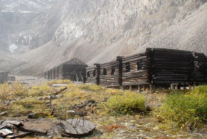
Rocky treeless valley in the Kodar Mountains, surrounded by 200-meter cliffs. Its name is associated with the abundance of different types of marble. It attracts tourists with its dark history. In the middle of the 20th century, there was a uranium mine and a labor camp for political prisoners serving as the main labor force. Uranium reserves turned out to be small, the camp lasted 2 years. His buildings, barbed wire, household utensils have survived to this day.

30. Kondui settlement
It is located in the middle of the steppe, 7 km from the village of Kondui. Fragments of a 14th-century settlement are related to the early history of the Mongol state in the territory of Transbaikalia. Here, on an artificial embankment, the palace of the Mongolian feudal lord, who belonged to the imperial family, was built. Nearby was a garden with gazebos, pavilions, a swimming pool. And although today the territory of the settlement is neglected, only the ruins of the castle and gravestones in the ground remain - there are always a lot of tourists here.

The Trans-Baikal Territory occupies a large territory, and more than a million people live in it. This area contains many interesting places. In the Trans-Baikal Territory, sights are associated with nature, culture, religion and many other areas.
The park was founded in 1999. It is located in the Duldurginsky district and occupies about 1400 sq. km. This area is unique in its geological characteristics. Here live:
- mammals - more than 30 species;
- birds - about 100 species;
- fish and amphibians - more than 20 species;
- insects - more than 400 species;
- plants - more than 1000 species (including lichens).
There are many natural attractions and historical and cultural sites on the territory of the park:
- natural monuments: char Alkhanay and natural arch Uuden Sume;
- rock remains: Demchog Sume, Zaguurdi, Sendema, Naro Khazhod, Choreo Shuluun;
- caves: Ekhyn Umai, Temple of Badmasambava;
- statues of Otosho, Namnanai Bagshi and the white Chakrasamvara;
- Buddhist Temple Demchog Dugan;

- stone chapel;
- commemorative suburgan to the 14th Dalai Lama;

- cascade of waterfalls Nine troughs;
- slab graves;
- stone slabs of Maniin Shuluun.
For tourists, there are 6 routes up to 6000 km long, 2 of which involve the possibility of traveling by car.
The reserve is considered one of the seven wonders of Transbaikalia and is an object world heritage UNESCO. The reserve is located in South-Eastern Transbaikalia and covers an area of 45.8 hectares. It was organized at the end of 1987 to protect bird nests.
The reserve is represented by steppe, lacustrine-steppe, forest and wetland landscapes. Protected areas are surrounded by a buffer zone. In the village of Nizhny Tsasuchey (Ononsky district), the central estate of the reserve was organized.
The fauna of the reserve includes more than 300 species of birds, and a third of them are listed in the Red Book. Fifty species of mammals also live here, including gazelle antelope, Dahurian hedgehog, tarbagan marmot and manul cat, which are listed in the Red Book.

This large Buddhist monastery complex is called Bribunling Dam. It is located in Chita, and was founded in 2002. Today, khural services and various rituals are held here.
The territory of the datsan is an ideal square with a side of 108 m - a sacred number. The prayer temple is also square. The building has three tiers, a tiled roof and carved elements - the datsan museum, which burned down in the last century, was taken as a model.
The central part of the temple is occupied by a two-meter statue of Buddha, which weighs 200 kg. In front of the entrance to the building you can see a sacrificial censer (800 kg) and cast-iron statues of lions. Visiting the temple is not limited by gender, age, religion.

The reserve is state-owned, located on the Khentei-Chikoi Highlands (south of Transbaikalia). It was founded at the end of 1973 and occupies almost 211 thousand hectares, including 36 thousand hectares of protected area. Most of the area is occupied by forests, so the reserve is considered mountain-taiga.
The flora and fauna of the reserve includes about 1,000 vascular plants, 250 bird species, 67 mammal species, and 1,200 insect species. The territory is a UNESCO biosphere reserve.

Tourists are offered several ecological routes. The length of some of them is more than 200 km, and the duration is up to a week. Moving is possible on foot, by car, horses.
This tract is one of the seven wonders of Transbaikalia - this place was included in this list in 2010. It is a sandy massif covering an area of about 3,000 hectares. This small desert is located in the Chara basin (the foothills of Kodar), 9 km away is the village of Chara (Kalari district).
The Chara sands are surrounded by swamps and larches (taiga) - this combination with the desert is unique. The sand is quartz, fine- and medium-grained. Ridges and dunes are formed from it, the height of which can reach 80 m, and the length - 170 m. Outwardly, the area resembles a Central Asian desert.
From the desert you can see the snow-capped peaks of the mountains, which seem close. In fact, they are about 40 km away.

This functioning Buddhist monastery is called Dashi Choipalling and is the oldest in the Trans-Baikal Territory. It was founded at the beginning of the 19th century. The datsan is located in the Mogoytuysky district (Tsugol village, Aginsky Buryat district).
The datsan was founded by three Agin clans. The main element of the architectural ensemble is the main temple. It combined Chinese and Tibetan architecture - traditional elements of the Buryat temple architecture. Every day Buddhist services are held in the temple. A person of any gender, age and religion can visit this place.

This national park was founded in 2014 and covers about 666,500 hectares. It included the liquidated Burkalsky and Atsinsky reserves.
The fauna of the park includes common and Siberian pine, fir, Siberian spruce, larch, Siberian pine and a number of other plants, including 38 protected species. The fauna of the reserve is also rich - 155 species of birds, 67 species of mammals, fish, amphibians. Some representatives of the fauna of the park are listed in the Red Book.
The territory of the park includes several natural monuments, including Bystrinsky char (mountain), Shebetui Lake, Lamsky Gorodok tract.
The temple was founded in December 2001 and belongs to the seven wonders of Transbaikalia. It is located on the station square in the center of Chita. The cathedral was built with donations.

The dimensions of the temple are impressive - it is the largest in Siberia and can accommodate 2,500 people, although on big holidays it turns out to be twice as many people. The cathedral attracts with a 60-meter bell tower. The main bell weighs 10 tons and is the largest in Siberia.
The interior of the temple consists of three parts - the vestibule, the central nave and the altar, separated from the central nave by a wall of icons. The temple library is remarkable, consisting of several thousand books, mainly Orthodox literature. Sunday school is organized for children.
It is located on the steppe plain of the same name and occupies about 46,000 hectares. The object was formed in 2004.
The flora and fauna of the reserve includes unique plant communities (Green Book of Siberia), rare species of birds and mammals, including bustards, white-naped and black cranes. Many representatives of the animal world are listed in the Red Books. The diversity of bird species makes up more than a third of the avifauna of the former USSR. Ephemeral wetland complexes are widespread on the territory.

This cave complex is located in the southeast of the Trans-Baikal Territory, 7 km from the village of Ust-Borzya. The object is a natural monument and represents two karst caves- Dry and Wet. The total length is approximately 150 m.
You can get into them only by going down a steep icefall. The descent is 12 m. The wet cave includes several galleries and grottoes. Water penetrates here and solidifies, forming magnificent natural sculptures. Once the caves were inhabited - human bones, fragments of tools of labor of primitive people were found here.

It is dangerous to visit the caves on your own, but you can do it on special tours - they are organized several times a month during the season.
The object is the Nerchinsk Museum of Local Lore and is located in Nerchinsk. The building was founded in the second half of the 19th century. It owes its name to the Butin family that owned it. The palace is considered the hallmark of the city, and its main exhibit is a Venetian mirror - a square with a side of 4 m, which caused a lot of controversy about how it was brought into the palace hall.
Much of the luxurious furnishings of the palace was lost. The spiral staircase, part of the carved elements, a huge chandelier in the ballroom, paintings, including the original by Aivazovsky, have been preserved.
Today, the palace houses a museum of local lore. The number of its exhibits is more than 20 thousand. The museum belongs to one of the seven wonders of Transbaikalia.

Mount Pallas and the Great Source
This mountain is also called the Watershed, the Great Watershed, the Mountain of the Five Seas - the rivers flow into 4 seas, and Baikal is called the fifth. It is located on the Yablonov Range, in the west of the Trans-Baikal Territory. The absolute height is 1236 m. The mountain is called the Point of the Great Divide, as it is the source of three great rivers - the Yenisei, the Amur and the Lena.
Pallas is located 35 km northwest of Chita and is included in the territory of the Ivano-Arakhleysky reserve. There are several tourist routes, but it is more convenient to pass through the Dvortsy tract. The length of the route is about 17 km.
The Great Source is considered an anomalous place and attracts people who believe in mysticism. They make up only a part of the tourists - the rest appreciate the uniqueness of the place and its magnificent nature.

Ivano-Arakhleysky reserve and Beklemishevsky lakes
The lakes are also called Ivano-Arakhlei or Chita. They represent the center of the reserve, the territory of which is protected.
Lakes are located west of Chita at an altitude of almost 1 km above sea level. The system consists of 6 large lakes, the water surface of which is 10 sq. km, as well as small reservoirs. 4 lakes belong to the Baikal system.
The reserve was founded in 1993 and occupies 210 thousand hectares. Its territory includes many recreation centers, which annually attracts more than 150 thousand tourists. There are more than half a thousand species of vascular plants, about 150 species of birds, 40 species of mammals and 800 species of insects in the reserve.
This building is called the most beautiful in Chita. It was founded at the beginning of the 20th century by the Shumov brothers, who own the Kruchininsky mines. Today, the office of the Federal Security Service of the Russian Federation for the Trans-Baikal Territory is located here. There is also a small Museum of the History of Management, where among the exhibits is a replica of the Chekist's office - the furniture is genuine, dating back to the middle of the 20th century.
The building claimed the title of one of the seven wonders of Transbaikalia. Previously, this building was the focus of business and cultural life not only the whole city, but also the region. The building has been perfectly preserved. This also applies to rich stucco decoration. The building consists of three floors, decorated with domes, figured parapets, decorative white columns.

This object is called one of the seven wonders of Transbaikalia. It is a natural monument. The lake is located in the Uletovsky district and is located almost a kilometer above sea level. Arey feeds on groundwater. Its water surface occupies 4.6 sq. km, and the maximum depth is 13.5 m.

The water in the lake is slightly alkaline and slightly mineralized. The lake is actively used for recreation - its healing waters and mud are effective for skin diseases and trophic ulcers.
Arey is surrounded by a pine forest, and its surroundings are rich in vegetation. On the coast there are two tourist bases: Ares and Crystal. The lake is attractive not only for its healing properties, but also for fishing.
The building was founded at the beginning of the 18th century. It is located in the village of Kalinino and is considered one of the seven wonders of Transbaikalia. Few such places of worship have survived in Siberia.
The building was restored in the second half of the 19th century. The church today is the oldest among the religious buildings of the pre-revolutionary period. The building is currently very run down. The temple is not active, but it is not difficult to imagine its former greatness. The restoration of the church is planned.

This mountain range is located in the north of Transbaikalia and is its highest point: the absolute height is more than 3000 km. It is often called the Trans-Baikal Alps. The length of the ridge is 200 km.
There are more than 30 glaciers on Kodar, which are natural monuments. The ridge is crossed by the Chara River, in the middle reaches of which there is charoite, a mineral used in jewelry.

This place is a small hanging valley in the Kodara mountain range. Previously, there was a Marble Mine, where uranium was mined - the main labor force was prisoners. Reminders of that time are the destroyed camp, towers, bridge - wooden buildings are partially preserved to this day. Due to the cold climate, some household items have also been preserved: metal utensils, stoves.
A commemorative plate was installed on the territory of the climbers who took part in the development of the mine.
Today this building is a museum, but once there was the Mikhailo-Arkhangelsk Church. It was founded in 1776 and is located in Chita. The museum was opened in 1985.
The building is made of wood and is the oldest in Chita. The museum's collection includes documents, books, letters, household items, personal belongings of the Decembrists, who were exiled to Siberia. In total, there are about 900 museum exhibits, including Bestuzhev's table and clock, Volkonskaya's box. The transfer of the building to the museum is also connected with the fact that the Decembrists used to get married in the church, and the daughter of the Volkonskys was buried next to the church.

Stone-cauldron, Small Bator and Big Bator
This rock is also called Togon Shuluun or the Chalice of Genghis Khan. The object is located in the Aginsky district and is a rocky remnant of natural origin 4 meters high. The name of the rock was due to the external resemblance to a tripod - an old pot.

For local residents, the stone-cauldron is a place of worship. A path is laid around the rock - the path of the city. The stone must be walked around an odd number of times in a clockwise direction.
The tract Malyi Bator is also called Baga-Bator. It belongs to the territory of the Aginskaya steppe nature reserve and is a granite remnant rock surrounded by trees - a sharp contrast with the local steppe.

Big Bator is located across the road and is the highest nearby peak. On the mountain there is a monument to Babji-Baras-bator - the legendary hero.
The Trans-Baikal Territory is a vast territory with unique nature. Most of the sights of this place are connected with this fact. Many objects are natural monuments. Of interest to tourists are other sights that reflect the history, religion and culture of the region.
The Trans-Baikal Territory is located in the eastern zone of Transbaikalia. It is part of the Historical and natural monuments of the famous Trans-Baikal Territory, attractions in this place at every turn. The area of this territory is 2.52% of the area Russian Federation. Everything here captivates with its scale and uniqueness. The main sights of the Trans-Baikal Territory constantly attract tourists. At all times, people were amazed by the variety of relief, natural beauties and
Sights of the Trans-Baikal Territory
Photos describing these beautiful places can be found in the article. But it is best to visit Transbaikalia in person. This is the only way to feel the greatness of nature, the height of the mountain peaks and the expanses of the steppes. Tourists are recommended to visit such places:
- Sokhondinsky reserve;
- Lake Arey;
- national park "Alkhanay";
- ridge Kodar;
- Butinsky Palace;
- numerous museums.
Sokhondinsky Reserve
In this protected place, nature is striking in its diversity. It combines several ecological systems:
- taiga;
- steppe;
- swamps;
- mountain tundra.
The length of the reserve is 211 thousand hectares. It is located on the Khentei-Chikoy highlands with the Sokhondo mountain range. Sokhondo loach is an ancient volcano. Its slopes delight with whimsical forms.
This place is characterized by dry and little snowy winters. The climate is continental. There are a lot of lakes of glacial origin. Their depth is more than twenty meters. Plankton and algae do not take root in them, in this regard, they are famous for their transparency, the water there has a slight blue tint.
In the Sokhondinsky Reserve, such rivers as the Selenga, Amur, Angara, Yenisei take their source. It is noteworthy that they belong to the basins of different oceans. The Amur belongs to the Pacific Ocean, and the Selenga, Yenisei, Angara belong to the Arctic Ocean.
Grow in these areas rare plants, which are listed in the Red Book, such as a leafless chin, real slipper, large-flowered slipper, smooth iris, spotted slipper, Siberian apricot, dwarf and Pennsylvania lily, Altai onion, Ayan backache, a couple of types of rhodiola.
Fascinates with its diversity and wildlife. At the moment, it has been found out that 255 species of various birds, 67 mammals, three species of amphibians, four species of reptiles, eight species of fish and 1200 species of arthropods live in the area.

Lake Arey
This reservoir is a hydrological monument of nature. If we talk about the Trans-Baikal Territory, the photo of the sights of which is in this article, first of all it is worth mentioning this wonderful lake. His fame is due to a combination of a number of factors:
- the lake is striking in the variety and quantity of fish, which is undoubtedly a huge plus for avid fishermen;
- the waters of Arey contain a lot of oxygen, but are poorly mineralized;
- mud at the bottom has healing qualities, eliminates numerous skin diseases;
- on the south coast there are huge anthills built by northern ants, some of the structures reach a diameter of 2-3 meters;
- at the very bottom of the Arey, a unique Arey potato grows, it cures diseases of the gastrointestinal tract.

Alkhanay National Park
"Alkhanai" is located on the territory of the Duldurginsky district. It is famous for its natural beauties. The whole nature of this place is saturated with legends and beliefs. From ancient times, the tribes of the Buryat-Mongols brought up love for this land in their descendants. They called for the unity of man with the outside world. In 1991, the head of the Buddhist clergy, the Dalai Lama, consecrated this land with his presence.
Day by day, interest in the national park "Alkhanay" is increasing. A huge number of believers come here to bow to sacred places and bathe in healing springs.
But not only natural monuments can be proud of the Trans-Baikal Territory. Historical sights are also striking in their uniqueness.

Trans-Baikal Alps - Kodar
This is amazing place located in the north of Transbaikalia. First of all, the Kodar ridge attracts tourists here. This is the highest point of Transbaikalia, a peak whose height is 3073 meters. The Kodar Ridge clearly stands out among the plateaus and midlands of Transbaikalia. Kodar is the "Transbaikal Alps". A traveler of any level can choose a route here that suits the difficulty.

Butinsky Palace
This palace belonged to the noble Butin family, who built unique and inimitable buildings for various purposes in the city of Nerchinsk. If you study the sights of the Trans-Baikal Territory, it becomes clear that the Butin Palace is undoubtedly the pride of the city of Nerchinsk.
The unique object of the palace is the Venetian mirror. They say that there is no such huge one in the world. Its dimensions are 4 meters long and 4 meters wide. To put it inside, they even dismantled the roof. The palace is also famous for its garden. Here you can find exotic plants that do not grow in the climate of these places.

Museum of the History of the SIBVO Troops
This landmark of the Trans-Baikal Territory was opened on the twentieth anniversary of victory in the Great Patriotic War. At the main doors there is an iron plate, on which the names of 1255 Siberian soldiers, Heroes Soviet Union. Three central halls are dedicated to the historical feat of the Russian people in the Great Patriotic War.
Everyone who goes to the Trans-Baikal Territory must visit these sights. We must pay tribute to the heroic feat of our ancestors.
This is only a part of the places that the Trans-Baikal Territory is famous for. Its sights can still be listed and listed. But it is better to go to this beautiful region and personally visit each of them.


