Mari Chodra National Park. Welcome to Mari Chodra National Park! Mari Chodra National Park short story
Established in 1985, the Mari Chodra National Park is an interesting natural-territorial complex.
Translated from the Mari language, “Mari Chodra” means “Mari forest”.
Purpose of creation
Protection of rare and endangered species of flora (115 rare and endangered species of flora are registered in the park), fauna and historical and archaeological monuments.
The entire territory of the park is covered with beautiful pine forests and coniferous-deciduous forests.
Numerous mineral springs, significant outlets of which are located in the valleys of the Ilet and Yushut rivers, are used for medicinal purposes in sanatoriums, rest homes and hospitals. A characteristic element of the landscape are lakes (sinkholes, inter-dunes, floodplains). Provalnye are located mainly on the southern, southwestern slopes of the Mari-Vyatsky ridge. Most of them are located in the lower reaches of the Ilet River - Lake. Yalchik, Glukhoye, Kichner, Shulgandan are natural monuments. The “Green Key” mineral spring and botanical geocenoses - the “Klenovaya Gora” tract, “Klenovogorskaya oak grove” - also belong to natural monuments. The historical and cultural complex of the park includes 2 historical monuments - an oak tree called Pugachevsky (according to legend, E. I. Pugachev stayed overnight with his detachment under the shade of this oak tree) and the old Kazan road. The oak differs sharply in its size among the forest stand. This is a gigantic tree with a powerful trunk, the diameter of which is 159 cm, which is part of the upper tier.
Active 14 tourist routes(on foot, on water, on horseback). Most popular places for recreation and tourism - Maple Mountain, lakes Yalchik, Glukhoye, Kichier.
Currently on site national park There are 14 recreational facilities: tourist centers, recreation centers, tourist towns, student sports camps, and sanatoriums. Based at the Mari camp state university An environmental camp was organized.
Address: 425040, Rep. Mari El, Zvenigovsky district, Krasnogorsky village, st. Central, 73


MARI CHODRA, national park in the Republic of Mari El. Founded in 1985. Sq. 36.6 thousand hectares. Located in the river basin. Ilet (left tributary of the Volga) in the southern part of Vyatsky Uval. Karst. Coniferous broadleaf forests. The fauna includes elk, squirrel, chipmunk, hare... ...Russian history
National park in the Republic of Mari El. Created in 1985 on the square. 36.6 thousand hectares for the protection of coniferous-deciduous forests of the Volga region (pine, linden, alder, oak, birch) in the river valley. Fly. 1155 plant species, of which about 10% are rare and... ... Geographical encyclopedia
Coordinates: 56°42′ N. w. 47°52′ E d. / 56.7° n. w. 47.866667° E. d. ... Wikipedia
Republic of Mari El Mari El Republic of Mary El Republic ... Wikipedia
Republic in Volgo-Vyatka economic. area. Pl. 23.2 thousand km², capital Yoshkar Ola; etc. major cities: Volzhsk, Kozmodemyansk. Formed in 1920 as the Mari Autonomous Republic. region, since 1936 – Mari Autonomous Soviet Socialist Republic, since 1990 – Republic of Mari El. Located... ... Geographical encyclopedia
Main article: Mari El As of January 1, 2011, the natural reserve fund of the Republic of Mari El includes 49 specially protected natural sites (SPNA), including: State nature reserve"Big Kokshaga"; National... ...Wikipedia
This term has other meanings, see Volzhsky region. Volzhsky district Yulser kundem Coat of arms ... Wikipedia
The largest state on the planet - Russia, has about 50 operating national parks. Most of them are located in the European territory of the country. One of the rich natural places Our state is the Mari Chodra National Park, the sights of which will be discussed in the article.
General information about the park
National Park "Mari Chodra" is located on the territories of the Morkinsky, Zvenigovsky and Volzhsky districts in the Mari-El Republic, which is a subject Russian Federation. The area of the park is 366 square kilometers. It was created in 1985 with the aim of protecting rare plant species, of which there are more than 100, from extinction. A photo of the Mari Chodra National Park can be seen in the article.
There are about 15 tourist routes in the park. The main attractions of the Mari Chodra National Park are lakes, for example, Yalchik, Glukhoe, Kichier, as well as the Ilet and Yushut rivers. One of the places frequently visited by tourists is Pugachev's Oak. Tourism in the park is important economic role for the republics of Mari-El, Tatarstan and Chuvashia.

The state organization FSBI Mari Chodra National Park controls and carries out tourism and security activities in the park. The property of this organization is a number natural objects and complexes located in the Middle Volga region.

Perhaps this is one of the favorite places for tourists who come to relax in the territory of the Mari Chodra National Park. There are several recreation centers on the shores of the lake that provide rental services for boats, bicycles and other equipment. According to tourists' reviews, there is beautiful beach made of sand with a magnificent view of the shores of the lake, and the areas of the recreation centers are quite well-groomed, there are shops. Tourists also speak positively about the food, which is varied and tasty.
Lake Yalchik is one of the largest natural reservoirs in the park. It consists of two small lakes connected by a bridge. In the summer, when the region is hot, this bridge often dries up, completely separating one lake from another. The waters of Yalchik are home to perch, pike and other types of fish, so for fishing enthusiasts, visiting one of the recreation centers on the shores of Yalchik will be a good choice.
Ilet River
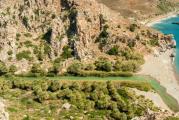
This is one of the popular tourist places National Park "Mari Chodra". The river has a length of more than 200 km, most of it is located within the park. The river itself is not wide (several tens of meters), the banks of the upper Ilet are steep, and the banks of the middle reaches and lower reaches are flat; sandy beaches. Surrounded by mixed forests.

The Ilet River is famous for the fact that amateurs come to it active recreation with the aim of rafting along it, mainly on kayaks and catamarans. The river flow is calm at a speed of 3-6 km/h, so it is well suited for beginner kayaking enthusiasts. There are several routes for rafting along the river, their length ranges from 20 to 90 km.
Pugachev Oak

It is perhaps impossible to imagine a holiday in the Mari Chodra Park without excursions to Maple Mountain, where the oak tree grows. The peculiarity of the oak tree is its size and age, so the diameter and height of the tree are 1.59 m and 26 m, respectively, and the age, according to modern estimates, more than 400 years. A stone was placed near this giant, on which there is an inscription testifying to the events that took place in the second half of the 18th century on Maple Mountain.
According to one legend, Emelyan Pugachev himself climbed this oak tree before making a trip to Kazan. According to another legend, the leader of the uprising climbed a tree after the defeat near Kazan to watch it burn in flames. In any case, it is reliably known that Pugachev’s detachments were in the summer of 1774 in the forests near Maple Mountain.
As for Pugachev's Oak itself, he could have witnessed the uprising, but Pugachev could not climb it, since at that time the tree was still too small. It is believed that Emelyan Pugachev, if he climbed a tree, it was another oak tree, which was even larger than the existing one. It dried up long ago and was cut down in the 40s of the 20th century.
Currently, excursions to the Pugachev Oak are carried out both in the summer on bicycles and cars, and in the winter on skis.
The Mari Chodra National Park is the most picturesque site in the Republic of Mari El. It is located in the southeast of the republic, in its most economically developed part, on the territory of three administrative districts: Morkinsky, Zvenigovsky and Volzhsky (Fig. 3.1).
The purpose of the creation is to protect rare and endangered species of flora (115 rare and endangered species of flora are registered in the park), fauna and historical and archaeological monuments.
The area of the national park is 36.6 thousand hectares, all lands are provided to the national park. Forest lands occupy 34 thousand hectares (92.9% of the park’s territory), including 33.5 thousand hectares (91.5%) covered with forest.
Non-forest lands occupy only 7.1% of the park's territory, among them: hayfields, pastures, arable lands - 1%, water - 2%, swamps - 1%, roads and clearings - 2%, the rest - estates and other lands.
The national park is located 60 km from the city of Yoshkar-Ola and 30 km from the city of Volzhsk. Its territory is crossed by the Yoshkar-Ola - Moscow railway and the Yoshkar-Ola - Kazan highway of republican significance.
Relief. Most of the territory of the national park belongs to the Iletsky upland-plain southern taiga region with the development of modern karst. It is a slightly undulating plain with absolute heights of 75...125 m above sea level, with island hills (Klenovogorskaya, Kerebelyakskaya). The active manifestation of the karst process led to the development of karst landforms - numerous sinkholes with a diameter of up to 50-60 m and sinkhole-type lakes with a depth of up to 35 m.
Climate. The climate of the area where the Mari Chodra National Park is located is temperate continental, characterized by relatively hot summers and frosty winters with stable snow cover. The average annual air temperature fluctuates in the range of +2...+3 ºС. The average long-term monthly temperature of the warmest month - July - is +18.6 ºС. The absolute minimum air temperature reaches -52 ºС. The average duration of the warm period of the year with temperatures above 0 ºС is about 200 days.
The territory belongs to a zone of unstable moisture; there are years with sufficient moisture, sometimes with excessive moisture, and sometimes with drought. Precipitation falls unevenly throughout the year. Their greatest number is observed in summer, the smallest in winter. An average of about 500 mm of precipitation falls annually. During the warm period (April - October) - about 150 mm. The highest monthly precipitation is observed in July - 60...700 mm.
The invasion of cold air masses from the polar basin by northern, northwestern and northeastern winds causes a sharp drop in temperature in winter, and frosts occur in spring and autumn. Continental air masses from the southeast often invade the park territory. In spring or summer they cause dry conditions, in winter - clear and frosty weather.
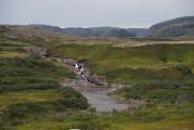
Reservoirs. On the territory of the park there is large number lakes and rivers, as well as oxbow rivers. Fly. Main river National Park "Mari Chodra" is the river. Ilet (Fig. 3.2) with its left-bank tributaries: r. Yushut, b. Arbaika, r. Uba, the river flows into it on the right. Petyalka.
The Ilet River has a significant longitudinal slope and a large number of springs. The river bed is winding, the banks are flat, swampy in places, and in the area of Klenovaya Gora - steep. The channel is composed of limestones and sands and is subject to active deformation.
The width of the channel reaches 20-40 m, the depth is relatively uneven. The Ilet River flows through a plain with slightly undulating terrain, covered with mixed forest. During the warm period of the year, the river's water content allows tourist boats to pass through.
Near Maple Mountain, more than 20 springs flow into Ilet. The most significant is the Green Spring, flowing at the foot of the mountain on the left bank of the Ilet, about 2 km above the mouth of the Yushut (Fig. 3.3).
Green Spring is a sulfate-calcium medicinal table source with a total water mineralization of 2.3 g/l.
Water can be used in the treatment of diseases of the stomach, liver, urinary tract and metabolic disorders.
An interesting outlet is the underground spring in the Ilet valley below the Green Key, on the territory of the village. Krasnogorsky. It pours out in the village from under the limestone slope. Then under the name r. Atlashka water from the spring flows through the village and after 2 km flows into the Ilet River. Thus, the village began with a settlement near a spring.
Local lakes add special picturesqueness to natural landscapes. In the forested Ileti valley there are many oxbow lakes of various shapes and sizes. All lakes are of sinkhole origin; they are forested, with the exception of Lake Kozhla-Solinsky.
Among them there are also rich in healing mud. Larger and more accessible lakes - Yalchik and Kichier - have long had health resorts of federal significance on their shores.
On Lake Yalchik of karst origin of the sinkhole type (length 1600 m, width 250...900 m, depth up to 35 m) there are rest houses, sports and recreational and pioneer camps (Fig. 3.4).
More than 300 people relax in them at the same time.
On the lake Kichier, almost equal in surface area to Yalchik, but with a shallow part overgrown in the east, has two sanatoriums.
Lakes Glukhoe, Konanier, Mushan-er, and smaller lakes that are far from roads are developed by unorganized tourists. Kozhla-Solinskoye Lake is located in the village. Krasnogorsky. The administrative center of the national park is located on the shore of the lake.
The water of forest karst lakes is highly transparent, with the exception of peaty water bodies. The lake was especially famous for its water quality before. Yalchik. But, in recent years, unfortunately, there has been a recreational overload of the lake with vacationers, free visitors and fishermen. This load led to lately to an increase in the turbidity of the water of a unique lake.
Soils. The soil cover is varied due to differences in topography and underlying rocks. The most common soils (81% of the national park area) include podzolic and soddy-podzolic soils. Typically podzolic soils are marked by small spots along the elevations of the relief, among the main background of soddy-podzolic soils. They occupy dry and freshly moistened areas covered with green moss pine forests. Soddy-podzolic sandy and sandy loam soils are noted on 5% of the park area. They occur on high relief elements. The upper soil horizons in many places are enriched with humus.
Vegetation. In physical and geographical terms, the territory of the Mari Chodra National Park is located at the junction of three natural areas: southern taiga (mixed forests), coniferous-deciduous (deciduous) forests and forest-steppe zone. Due to the diversity of landscapes, there is a natural uniqueness and richness of vegetation and flora.
Therefore, the territorial ecological balance is quite high. Ecological balance in territorial areas has developed over centuries. In this regard, it is necessary to analyze the component ecological disequilibrium due to high anthropogenic, primarily recreational, load.
The national park is dominated by forest vegetation, where the largest proportion is pine forests(50.2%). Before the creation of the national park, clear and selective logging was carried out in this territory, and pine crops were created in the vacated space. Spruce forests are presented mosaically and occupy only 4.6% of the forest area.
Thus, the park is a post-industrial territory with components of the vegetation cover and virgin land preserved in their original form. For object of study spruce forests are accepted that are directly adjacent to the village of Krasnogorsky and suffer the greatest anthropogenic load from local residents, automotive and railway, arable land, as well as from the security zone of the international gas pipeline Urengoy - Pomary - Uzhgorod.
Two types of oak forests are noted in the park's vegetation. At higher elevations (Klenovaya Gora, Katay Gora) oak forests grow with the participation of linden, maple, elm, elm with an admixture of conifers. These are upland oak forests. On the floodplain of the river In Ilet there are floodplain oak forests. Secondary forests - various types of birch and aspen forests - occupy about 1/3 of the park's area. They stood here instead of felled coniferous stands. The area occupied by meadows is insignificant. They are found in small areas in river floodplains, as well as near settlements, in clearings. In the southern part of the national park, dry meadows with elements of forest-steppe flora are noted, so the study of floodplain meadows of different formations is also of scientific and practical interest.
The flora of the park includes plants listed in the Red Book of the Russian Federation - five species, and plants listed in the Red Book of the Russian World Economy - 50 species. Of the plants in the Red Data Book of the Russian Federation, four types of orchids should be noted.
The largest orchid in the national park's flora is the lady's slipper, a beautiful perennial plant crowned with reddish-brownish-yellow flowers. Another extremely rare orchid in the park is the red pollenhead, found on calcareous soils and blooming irregularly. Feather grass, also listed in the Red Book of the Russian Federation, together with gypsophila paniculata, sheep's fescue, and Keleria siza are forest-steppe elements of the park's flora and are found in its southern part.
Among the typical taiga species, Siberian fir, white sage, bilberry and others are noted, as well as relict species - common ram, diphasiastrum oblate and spikelet, Parisian bilepole, grandiflora uniflora, common grasshopper and others.
Relict plants can still be found in sphagnum swamps, occupying a small part of the park's territory, these are swamp gammarbia, multi-spike cotton grass, various types of sundews, as well as swamp sedum, lopar willow and Vinogradova, listed in the Red Book of the Republic of Mari El (RME).
The rarest tree of the Mari Chodra National Park is black poplar (sedge), listed in the Red Book of the Russian Medical Economy, found in the floodplains of the river. Ilet and r. Yushut.
Animal world. The fauna of the Mari Chodra National Park is of a mixed nature, due to the peculiarities geographical location territory occupied by the park. The fauna includes taiga species (brown bear, elk, capercaillie, hazel grouse); species of coniferous-deciduous forests (yellow-throated mouse, squirrel, oriole, green woodpecker), as well as forest-steppe species (brown hare, field mouse, reddish ground squirrel, common hamster). Such biological diversity not only among plants, but also animals, makes the territory of the national park very attractive for scientists and students.
The component balance between plants and animals, as well as fungi and microorganisms, can be studied on the basis of the methodology proposed in this book.
These are tasks for future young researchers.
In total, there are 56 species of mammals in the national park, of which the most representative is the order of rodents. The order of predatory animals is represented by the mustelid family: weasel, ermine, polecat, pine marten, European mink, American mink. The red fox is often seen. The reservoirs are home to muskrat, otter and beaver, which were brought and released into the park in 1947.
A muskrat also lives in the park - rare species, listed in the Red Book of the International Union for Conservation of Nature and the Red Book of the Russian Federation. Representatives of the ungulate order - elk and wild boar - are rare.
The avifauna of the national park is represented by 164 bird species, of which 12 species are listed in the Red Book of the Russian Federation and 38 species are listed in the Red Book of the RME. The most representative orders are Galliformes (grouse, hazel grouse, black grouse), Anseriformes (mallard, greylag goose, whooper swan, wigeon, common goldeneye), and owls (snowy owl, eagle owl, long-eared owl). There are many falconiformes (osprey, falcon, kestrel, hobby hobby, golden eagle, buzzard, white-tailed eagle, short-eared snake eagle, black kite) and passerines (raven, magpie, jay, finch, siskin, goldfinch) in the park.
The rivers and lakes of the park are home to more than 43 species of fish - such as catfish, pike, golden and silver crucian carp, carp, tench, and bream. The channels of the Ilet River are home to a rare species - European grayling.
Tourism and recreation. For numerous tourists and vacationers, organized excursion and tourist routes are offered.
They pass through picturesque places territory of the Mari Chodra National Park and provide an opportunity to get acquainted with the rich and diverse nature and historical past (Fig. 3.5) of the park.
Along all routes you can see frequent changes in landforms and natural landscapes. There are quite a few karst sinkholes here, if you want to visit the Museum of Nature of the Mari Chodra NP, historical monuments(Pugachev Oak, Old Kazan Highway), natural monuments ( mineral spring Green Klyuch, Klenova Gorsk oak grove, lakes Yalchik, Glukhoye, Kichier, Shut-Er, Kuzh-Er, Ergezh-er, Shet-er, and also look at Maple Mountain from observation deck on Shungaldan Hill).
In a specially protected area, protection environment, first of all, comes down to caring for existing natural objects. And for this it is necessary to understand the life of all inhabitants of the protected area, including humans. Therefore, engineering and environmental studies are necessary, in particular forest stands.
The local population and visitors should not only have a love for nature and a unique region, but also an intuitive ability to measure the properties of natural objects for timely diagnosis of the quality of trees and other plants, the condition of animals and flora around populated areas.