Jackson Cole - Devil's Canyon. Devil's Places in the USA Devil's Canyon
If an unusual incident happened to you, you saw a strange creature or an incomprehensible phenomenon, you had an unusual dream, you saw a UFO in the sky or became a victim of alien abduction, you can send us your story and it will be published on our website ===> .
This article will focus on remarkable natural formations that bear names associated with the Devil and are located on the territory of the United States. All of them are considered mysterious places where mysterious and frightening phenomena take place.
devil's canyon
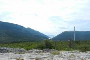
In the southwestern United States, in Arizona, there is one of the largest canyons in the world. It is a giant earthen bowl with a diameter of 1200 meters and a depth of 180 meters. Presumably, the crater arose more than 40 thousand years ago, and a 50-meter meteorite helped it to form, which fell to Earth. Its weight was 300 thousand tons, and it flew at a speed of 45-60 thousand km / h.

When a meteorite fell, an explosion occurred that can only be compared with the explosion of 1000 atomic bombs, similar to those dropped on Hiroshima. Fragments of meteoric iron can still be found around the canyon to this day.
Even before the time when this area became known to scientists, the canyon was often visited by the Indians who lived earlier. They came to make spears and tools for themselves from fragments of a meteorite. The local tribes have a huge number of legends and legends associated with this sacred place.

There are legends that near the Devil's Canyon almost every night you can observe airglows and often a UFO hangs over the canyon, and locals talk about mysterious geomagnetic anomalies inside the crater. It is all these diverse fantastic stories that gave the name to the canyon, which is visited annually by hundreds of thousands of tourists.
More recently, a museum was built near the canyon, which contains photographs of all the "lunar" astronauts in full space gear. But no one even realizes that all these pictures were taken not on the Moon, but in the Devil's Canyon.
devil's ring
In Pennsylvania, along the Delaware River, in Bucks and Franklin counties, there is a mysterious and frightening mountainous area called the Devil's Ring, the Stone Garden or the Ringing Rocks. The rocks here really have their own voice.

Bringing superstitious horror to everyone who happens to hear it, from time to time they spontaneously begin to "sing", making ringing sounds in a very wide range of pitch and volume - from barely audible howls to trumpet voices and bell ringing. Moreover, a person experiences uncontrollable fear among these rocks, even if they are silent.
To hear the sound of these stones yourself, you need to hit them with a hammer.
This is the only place on Earth where such phenomena have been recorded. Except for the singing colossi of Memnon. But those, firstly, man-made sculptures of the ancient Egyptians, and secondly, their phenomenon is explained more simply: the desert wind finds loopholes in collapsing monuments and, breaking through the cracks, makes soul-chilling sounds. Maybe something similar is happening with the Ringing Rocks.
Scientists became interested in the devil's ring, honestly trying to solve the riddle of nature, but could not come to a consensus. They studied the external and internal structure of the rocks, their shape and size, but did not reveal anything special.
"Musical abilities", according to them, are equally possessed in this strange place both individual cobblestones and huge blocks of indefinite shape weighing up to several tons.
The assumption was experimentally verified that dense, homogeneous, fine-grained rocks ring - quartzite, rhyolite and basalt, of which those rocks are composed, but it was not confirmed either.
And no one has yet put forward other versions. Scientists could not explain the origin of the reddish-brown color of the peaks of the Ringing Rocks, which contrast sharply with the neighboring mountains, which seem to consist of the same lithological material.
American researcher Ivan T. Sanderson discovered another anomaly in the Devil's Ring zone. He found a strange plateau with an area of 28 km 2, surrounded by a dense ring of forest 15 meters high. Trees, grass and shrubs are everywhere you look. But this plateau is like a bald patch, on which there is not even a hint of flora or fauna - no signs of the vital activity of even the most primitive living organisms, not to mention the traces of animals common to mountains and forests.
In their reports, Sanderson and his companions noted that, having set foot on the plateau, they each time experienced a feeling of animal fear.
devil hole
In a desert place in the state of Nevada, there is a kind of unique formation - a deep crack called the Devil's Hole. Legends say that this is a window into underworld in other words, to the underworld. A hole through which an evil spirit visits us when it plans to create some kind of dirty trick on the earth. Devil, you have to understand.

True, for such an important person the word "hole" sounds somehow disrespectful. Probably, here, say, the Devil's Gate would be more suitable. Geologists believe that the mysterious failure to the "center of the Earth", the true depth of which no one has yet been able to measure, is a gap that arose on a break in the earth's crust, where two tectonic plates were not too tightly fitted to each other.
The dimensions of the gap-hole on the scale of the planet are small - only 9 x 12 meters at the surface. But its depth is impressive. Below 120 meters from the surface, the crevice is filled with groundwater, which formed an underground lake in this place. What is the depth of the lake itself is unknown. It is possible that the fissure goes into the bowels of the planet deeper than the famous Kola super-deep well.

Further more interesting. The researchers recorded an anomalous content of heavy hydrogen, deuterium, in calcite deposits on the walls of the failure. But natural heavy hydrogen is the basis of "heavy water", in which, as you know, nothing living can exist.
Even the seeds of plants do not germinate in it. And if an animal is given such water to drink, it will simply die of thirst. But here's the paradox: in the underground lake of the Devil's Hole, not single-celled and not worms, but rare species of fish live and breed quietly.
Since ancient times, many meteorites have been falling to Earth. Some of them do not leave any trace, landing smoothly on the surface, such as the famous Goba meteorite in Namibia. But in the vast majority of cases, the fall of a celestial body is accompanied by the appearance of a crater. One of these craters is located in the state of Arizona (USA), 30 kilometers west of the town of Winslow.
Arizona crater- footprint of a giant meteorite
Arizona crater on the map
- Geographic coordinates 35.027729, -111.023100
- The distance from the US capital of Washington is a little more than 3000 km in a straight line or about 3500 km on the roads
- The nearest local airport is in Winslow, 30 km away.
- To the nearest International Airport Phoenix Sky Harbor approximately 200 km or 320 km by road
The Arizona crater is a classic meteorite impact — it has an almost perfectly round shape with a diameter of about 1200 meters, and its edges rise to a height of up to 46 meters from the surface. The depth of the funnel, according to some sources, is 229 meters, according to others, 174. To be honest, we were not there and, accordingly, we did not measure with rangefinders or tape measures. Even the Russian-language and English-language Wikipedias carry different data. It is quite possible that in one case the depth was measured relative to the plain, and in the other case relative to its edges. So the truth is out there somewhere.
Several names of this crankcase are known. These are the laconic Meteor Crater (Google Maps knows it under this name), the Devil's Canyon Crater (in the original Canyon Diablo Crater) and the Berringer Crater (in the original Barringer Crater). But, nevertheless, it is usually called the Arizona Crater. As well as the famous geological formation, everyone in the same Arizona simply calls the Arizona wave (and on the maps it is marked as “The Wave” - translated as “Wave”). It is located about 220 kilometers to the north.
The calculations of scientists regarding the size of the meteorite itself are ambiguous. But the data is roughly as follows: The crater was formed about 50,000 years ago due to the fall of a meteorite with a diameter of about 50 meters and a mass of 300,000 tons. Its speed was over 40,000 km/h.

The energy of the explosion, according to some estimates, is 3 times higher than the Tunguska meteorite. The power of the explosion is thousands of times greater than the infamous atomic bomb dropped by the United States on the Japanese city of Hiroshima. There are no exact data, but the approximate capacity is estimated at 150 megatons of TNT.
As we have already said, one of the names of the crater is Berringer Crater, after the name of a man who proved all his life that it was a meteorite crater, and not a volcanic one, as was previously believed.
A bit of history about Arizona Crater
Such a gigantic formation, of course, was known to the local Indians from time immemorial. Their legends say that once upon a time, the God of Fire himself descended from heaven on a fiery chariot to these places and left such a huge funnel as a keepsake. By the way, this indirectly confirms that the crater is really from a meteorite. The Indians considered this place sacred. Around them they found numerous metal fragments from which they made amulets. It was believed that they protect from evil forces. The Indians were kind to these amulets, that even during burial they used them as one of the main attributes of the ceremony of leaving the deceased to the “Land of the Happy Hunt” (as the Indians called the afterlife).
Scientists only in 1891 learned about the existence of this crater, but considered it volcanic. Until Daniel Moreau Barringer, a mining engineer, found out about him in 1902. He then put forward the idea that the crater appeared as a result of a meteorite fall. Given the size of the funnel and the presence of metal fragments in the vicinity, Berringer suggested that the mass of the meteorite is quite large, and it consists mainly of iron with an admixture of nickel and platinum. In those days, 1 ton of iron cost about $125. Berringer estimates that the meteorite could be worth as much as $1 billion. In 1903, he buys the territory on which the crater is located and begins excavations. Until the end of his days, Daniel tried to dig up a meteorite, but, unfortunately, he did not reach his goal. 26 years of grueling excavations were in vain. Despite the fact that Berringer was able to dig to a depth of 419 meters and find a lot of meteorite fragments around, the most important and coveted piece of metal was never found. At the bottom of the crater, mines and fenced excavation sites remain to this day.

Today, the Arizona Crater is a well-known landmark of the state of Arizona in particular, and the whole country in general. Tourists from all over come here all the time. the globe. They have viewing platforms.

To maintain and increase attention to the crater, local residents often talk about the appearance of a glow (of course, mysterious) over the crater, periodic UFO sightings and geomagnetic anomalies in the crater itself (of course, all with the adjectives "mysterious").
Some experts in the field of parapsychology and parallel worlds argue that the Arizona crater is the gate to hell. Rumor has it that people periodically disappear in the crater area, and some tourists experience inexplicable nervous tension, but there is no reliable information on this.

Arizona Crater photo


Arizona Crater (Barringer Crater, Devil's Canyon) is one of the largest and best-preserved meteorite crater located near Diablo Canyon in northern Arizona (USA). The modern dimensions of the crater: diameter - 1220 m, depth - 184 m, elevation of the shaft 50 m. It is assumed that the crater arose as a result of a two million-tonne nickel meteorite falling to Earth about 50 thousand years ago the power of an explosion of 1000 atomic bombs, similar to those dropped on Hiroshima.
Its popularity is determined by many reasons. First of all, this is the first such formation for which it was proved that it arose when a huge meteorite hit the Earth. More than 30 tons of meteoric iron fragments were collected in and around the crater, and the largest of them weighed 639.1 kg. In addition, around the crater in the soil and on the surface there is a mass of small and tiny balls and dust particles of meteoric iron. Moreover, this is the first meteorite in which diamonds were found.
The first people settled near the crater 25 thousand years ago. And the Indians who inhabited this area told a legend that once a fiery god descended in a chariot, after which the crater remained. Therefore, the Indians wore fragments of a meteorite as amulets and placed them in the graves of their dead relatives.
Scientists have known about the existence of the crater only since 1891. In 1902, mining engineer Barringer bought a piece of land with a crater. Barringer spent 26 years of his life looking for a meteorite and trying to convince others that his crater is of extraterrestrial meteorite origin. From that time to the present, the Arizona crater is the only natural object of this type, privately owned. It belongs to the third generation of the Barringer family.


The crater has been used more than once as a setting for filming fantastic films about earthlings traveling to other planets, about the arrival of huge UFOs in their secret harbor closed from prying eyes.
This is not the largest meteorite that fell to Earth. In Antarctica, on Wilkes Island, a meteorite crater 241 kilometers in diameter and 800 meters deep was discovered in 1962. In Canada, on the coast of Hudson Bay, there is a crater with a diameter of 443 km.
This is one of the most beautiful and unusual places in Ukraine where I was. Aktovsky canyon is often called the "Valley of the Devil". Between high cliffs meanders a small river Mertvovod. According to legend, the ancient Scythians sent their kings along its course on their last journey. The rocks around rise to 50 meters. How and why such a place arose among the flat steppe is completely incomprehensible. This is the American Grand Canyon in miniature. The landscapes here are incredibly beautiful, especially at dawn - with the first rays of the sun, the rocks become peach-pink. Welcome to Devil's Valley.
Autumn should be met where it is especially beautiful. Last year, such a place was for us, now it is Aktovsky Canyon. We had been planning to go there for a long time and finally broke out, and even with tents, so we managed to shoot at dawn. Getting here is very difficult, but worth it. This is one of the most beautiful and unusual places in Ukraine where I have been. There is a map at the end of the post detailed description the best way to get around. For now, enjoy the beauty.  2.
2.
To begin with, by tradition, the history of the place in two paragraphs. This is one of the oldest landmasses in Eurasia, formed from volcanic rocks. The sea here dried up 60 million years ago. But that was too long ago, we are more interested in the present. Aktovsky Canyon is located in the valley of the Mertvod River. This is a tributary. The length of the entire canyon is about five kilometers. The height of the rocks is up to 50 meters. In some places sheer stone walls are formed. Huge boulders lie on the shores.  3.
3.
 4.
4.
Like Aktovsky Canyon and the entire course of the Mertvovod River is included in national park"Bug Guard". This place is called "Valley of the Devil" and "Small Crimea" - granite-basalt rocks are very similar to the Crimean ones.  5.
5.
Rocks in the village of Aktovo. This is the most popular section of the canyon. But, by the way, not the most beautiful. More will be better)  6.
6.
For the first time I saw how tourist buses drive through an open field. It's beautiful here, but there are a lot of people. Therefore, we go further.  7.
7.
The place is very popular, but it is incredibly quiet and cozy here. Tourists rarely reach the canyon itself, limiting themselves only to rocks in the Aktovo village itself. It is difficult to drive further, only photographers, climbers and ecotourism lovers wander into the valley itself. So we are on our way there.  8.
8.
 9.
9.
 10.
10.
 11.
11.
 12.
12.
Dawn. The sun rises due to landing opposite the canyon, so the rocks are pink in the morning.  13.
13.
 14.
14.
Many rituals of the ancient tribes were held in these places. Most of the Scythian kings are buried in the valley. According to legend, the rulers were sent on their last journey along the Dead Water. Hence the gloomy name. Herodotus calls this river Exampey, which literally means "dead water". 15.
15.
 16.
16.
There is another legend - during one of the Tatar raids, local residents cooked a poisonous broth and poured it into the river upstream from the Tatar camp. The enemies drank some water and died. According to another version, the river got its name after a terrible battle between the Zaporozhye Cossacks and the Turks, after which the river water was not visible because of the bodies of the dead. 17.
17.
As for me, it is from this point that the most best view to the canyon and the valley of the Mertvod river.  18.
18.
The canyon is considered the only one in Europe, which, in terms of geological and landscape indicators, exactly repeats the famous canyons. North America. A kind of Grand Canyon in miniature. 19.
19.
 20.
20.
 21.
21.
The sun has risen and the rocks no longer seem peach.  22.
22.
 23.
23.
It is hard to believe, but a hundred years ago the river was navigable. The Soviet government decided to equip collective farms here - the channel was blocked in many places with dams, the banks were turned into fields. The course of the river slowed down, the bottom silted up, the channel was overgrown with reeds. They say that in some places the layer of silt and mud reaches five meters, in some places the river has turned into a swamp that can be forded. But in some places, small murmuring cascades and even waterfalls are still preserved.  24.
24.
 25.
25.
 26.
26.
The best place to set up camp. Convenient descent to the water, there is a place for a fire and tents. And all around is beauty.  27.
27.
 28.
28.
 29.
29.
Locals come here to fish.  30.
30.
 31.
31.
 32.
32.
 33.
33.
local flora. They say that several hundred species of different plants grow here. Many of them are listed in the Red Book. I don't know what it is, but it looks nice.  34.
34.
 35.
35.
 36.
36.
 37.
37.
 38.
38.
Finally - two panoramas. Pictures are clickable.
39.
How to get to Aktovsky canyon:
The road is not for the faint of heart. From Odessa it is best to go through Nikolaev, and further along the Southern Bug, through New Odessa and Voznesensk. At the exit from Voznesensk, in front of the church, turn right. The road to the village of Trikraty is quite tolerable. In the village itself there is a wonderful landmark - the old road, paved with paving stones, you go there. In about 10 minutes Arbuzinsky Canyon will appear on the right. We pass by, we enter the village. The main road turns left and after about five minutes it ends in a field. Right behind it are the most popular rocks. The canyon itself is upstream. You need to go there through the fields and dirt road. You leave the village, near the tractor base to the right, then along the field until landing - there will be a small passage through it. Further the road goes between the canyon and the forest. It's easier to show on a map than to explain. The only correct path from the village to the canyon is highlighted in orange. Yes, they are all primers. Drive 20-30 minutes.

1 - the most popular rocks (photo 2-7), 2 - an impromptu parking lot, 3 - a tractor base, you need to turn right near it, 4 - a lake, 5 - here we dive through the landing, 6 - the steepest view of the canyon (photo 15- 23), 7 - another cool place with a convenient descent to the water (photo 27-33), 8 - a small waterfall (photo 24-26).
P.S. Firewood for a fire can be found on the spot, but for them you need to go to the landing, on the shore everything was dismantled a long time ago. So if you are too lazy to walk a lot, bring coal with you) It is also advisable to take a folding brazier with you. There are few equipped places for fires, and the grass all around is dry - it can catch fire.
Liked? Click like and repost, let others see)
Photo reports from other canyons and quarries in the south of Ukraine.
Meteorites and asteroids are the heavy artillery of space. They plowed up, opened its crust to the very depths of the mantle, covered the surface with scatterings of craters. Our Earth, unlike an airless satellite, is protected from space rocks. In it, most of the "aliens" burn out before they touch the surface. But there are meteorites that break through the barrier and are capable of destroying entire cities and countries. Arizona Crater, also known as Barringer Crater and Devil's Canyon, reminds us of this - a trace from the closest meteorite fall to us.
How did the crater appear?
50 thousand years ago, the Arizona desert in the United States was not such a hot and dry place. Then it was a flowering field, crossed by forests and oak forests - the landscape was somewhat reminiscent of the forest-steppes of Ukraine and Russia. Mammoths and giant sloths roamed them, not much inferior in size to mammoths. The valley was cut by numerous rivers, and the rains were plentiful; nothing prevented the lush growth of vegetation. But one day the primitive idyll was interrupted.

The peaceful slumber was torn apart by a bright flash, and then a growing thunder - a fireball appeared in the sky, which collapsed to the Earth with lightning speed. A meteorite with a girth of 50 meters and a mass of 300 thousand tons cannot be called large - there are hundreds of times larger. Nevertheless, the explosion from the fall of the Arizona meteorite was colossal. The power was 150 megatons of TNT equivalent, which is three times more powerful than the most powerful detonated nuclear charge in history, the Tsar Bomba. This is not strange, because the fallen space rock belonged to the "heavy class" of meteorites containing a lot of nickel and iron.
The force of the impact of the meteorite devastated the surroundings. The 7-magnitude earthquake reached over 300 kilometers, and the sound of the explosion was as strong as the noise of an active construction site. A fireball with a radius of 700 meters rose above the horizon - its radiation set fire to grass and trees nearby. Rain from rubble and debris covered the area with a radius of 100 kilometers. And the meteorite itself half evaporated from the force of its own impact - and its fragments scattered around the crater and its environs.
Arizona Crater is visited by thousands of tourists, but they are not allowed to go down. On our site, with the help of Google StreetView, you can walk along the bottom of the crater like a real scientist!
Arizona meteorite crater today
However, time passed, and the Earth healed the wound on itself. Water and air smoothed out the outlines of the crater and transformed its appearance - it even managed to visit a lake into which nearby rivers flowed. The bottom was covered with sedimentary soil and seasonal vegetation, growing after rare desert rains, and the edges were smoothed. But the peculiarities of the desert climate of Arizona allowed the crater to be preserved better than many of its counterparts. Today we highlight:
- A funnel with a diameter of 1.2 kilometers and a depth of 170 meters. A small skyscraper will fit in it with a horse! In addition, the rim of the crater rises to a height of 46 meters.
- Unusual shape of the crater. Usually, impact marks are round or ellipsoid - and the Arizona crater, which was photographed from the air back in the early 20th century, resembles a rounded square, like a chocolate bar. Scientists explain such anomalous outlines by shifts in the earth's crust caused by the impact force.

- The largest well-preserved crater on the planet. Yes, on Earth there are funnels from meteorites and more. The record holder, the Vredefort crater, stretches for 125 kilometers in all directions - several dwarf European countries. However, it is only possible to understand that Vredefort is a crater from a satellite. Water, wind and movement blurred the clarity of its shape. And the Arizona crater is not only intact, but also looks almost fresh, as if a meteorite fell recently.
Although the Indians have been collecting meteorite metal fragments for spears and arrows since ancient times, scientists have long thought that the Arizona crater was left from a volcano, and not from a cosmic body. However, the engineer Daniel Berringer, after whom the crater was named, thought otherwise. He believed that only a meteorite could dig such a huge bowl-shaped hole, and he hoped to find it under the crater and enrich himself. He bought the entire territory of the crater and searched for the remains of space iron for decades. According to legend, he died of a heart attack when physicists calculated that there was nothing to look for underground.

However, now the crater brings his family a considerable income. Scientists are looking for minerals on the inviolable bottom of the crater that can give them doctoral degrees, tourists admire the majestic remains of a cosmic explosion from viewing platforms. In the USA, the Arizona crater is called the "Grave of Hats" - a strong wind rages over the edges of the funnel, which blows caps and hats of dozens of tourists into the inviolable bottom of the crater. And it was in the crater that the astronauts of the Apollo program worked out a mission to the moon. After all, this is the only place on Earth whose landscape repeats the relief of our satellite.