Strange objects in google maps. The strangest objects on Google Earth maps
The man, who identified himself as "Dr. Boylan", believes that the darkened area in this picture and in several other locations hides extraterrestrial beacons of aliens.
2. Ramstein Air Force Base, Germany
This NATO air base is the starting point for Operation Iraqi Freedom forces, and for this reason, it can certainly be a target for terrorist attacks. This may explain why this object is partially cut from Google Maps.
3. Pacific Northwest, USA

What exactly are we not seeing in this photo? This place is located near the border of the states of Washington and Oregon. Enthusiasts personally examined this place and found nothing remarkable, except for the sinister appearance of the fence and the unmarked entrance.
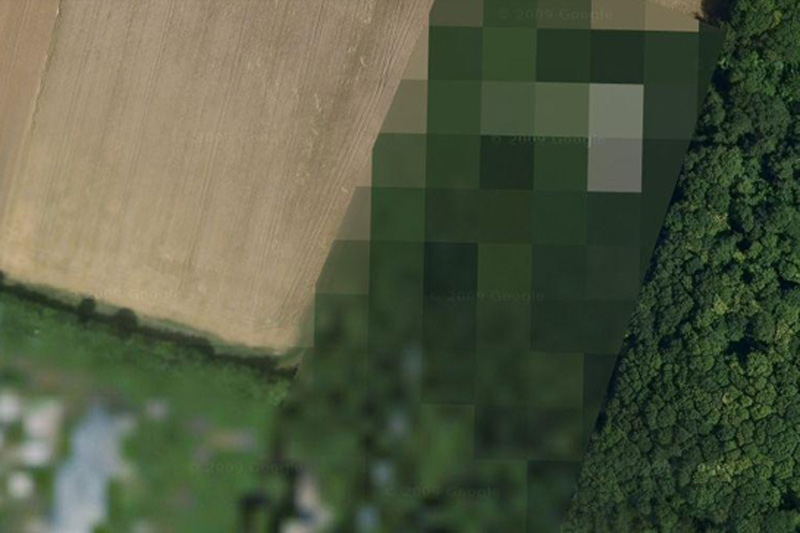
4. Shazalombatta Oil Refinery, Hungary

This is one of the strangest examples of censorship in Google Maps - this place is simply painted over in green. The factory area has been removed, the buildings have been erased, and all you can see is regular grass.
5. Huis Ten Palace, Holland

It's hard to imagine that the Dutch royal family could be a prime target for a crazed terrorist, but Royal Palace Huis Ten is heavily blurred on Google Maps when viewed from any angle. (However, the surrounding area and trees can be seen with crystal clarity at close magnification.)
6. Unknown zone, Russia

No one knows what is hidden in this region. One of the opinions is that there is a “radar station or missile interception system” there, and some argue that the image of the surrounding area is pasted from another region of Russia.
7. Mobil Oil Corporation, Buffalo, New York, USA

Some criticize Buffalo-based Mobil for blurring images of its operations, saying that oil corporations are not of much interest to terrorists. On the other hand, we do not know what the terrorists themselves think.
8. North Korea

Everyone has heard of this country, which is part of the supposed "Axis of Evil", but very few have ever visited it. You won't see it on Google Maps either, as the entire country exists in the imagery, but without road markers, street names, or any other identifying details.
9. Reims Air Base, France

The reasons why this air force base is blocked from Google Maps are unknown.
10. Indian Point Power Plant, New York, USA

Many members of the United States government called for a shutdown of the Indian Point power plant. Environmental considerations aside, according to energy experts, the power plant is not strong enough to withstand an earthquake like the one that recently devastated Japan.
11. Volkel Air Base, Holland

It is rather amusing to see how this air base is grossly blurred on satellite images, however, WikiLeaks has published diplomatic correspondence that confirms the presence of nuclear warheads on the territory of this base.
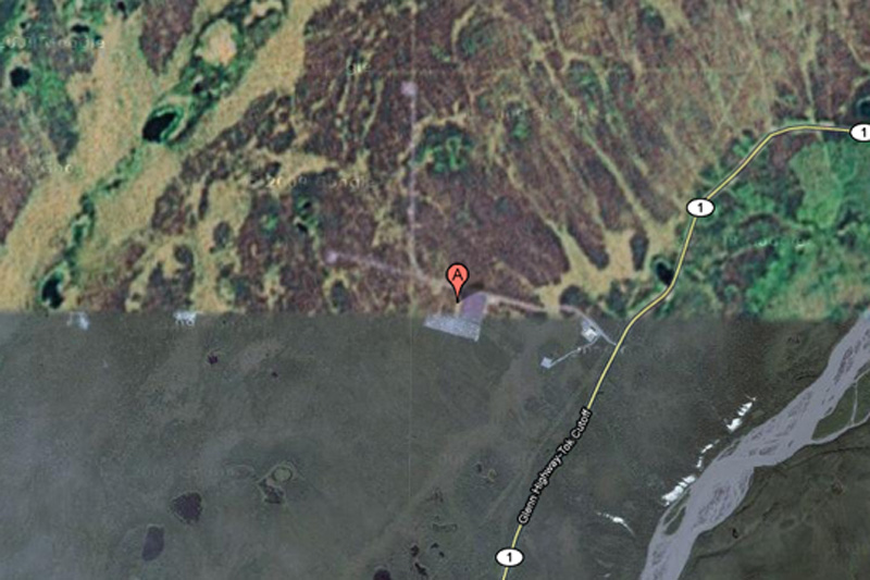
12. HAARP, Gakona, Alaska, USA

HAARP (High Frequency Research Program) northern lights) is one of the most controversial operations currently underway in the United States. Gakona, the site of research, and the ionosphere experiments there, are revered by some conspiracy theorists as the cause of everything from floods to earthquakes, but there is very little evidence for this.
13. Mazda Laguna Seca Raceway, Salinas, California, USA

This is one of the strangest examples of censorship on Google Maps: the Laguna Seca race track in Salinas, California. The strangest thing about this is the fact itself: this is an apparently harmless race track.
14. Babylon, Iraq

While the surrounding area is perfectly visible, the city of Babylon itself is blurred in the pictures. One can argue that this has something to do with the rebels there ...
15. national park Tantauco, Chile

Why is this endangered species sanctuary completely cut out of Google Maps? Nobody knows.
16. The Hill, Elmira Correctional Facility, USA

This is the highest security prison in New York State. Perhaps, after the Attica prison riots and several incidents of uprisings and mass escapes around the world, the authorities may indeed be worried about the possibility of helicopter escapes.
17. House of Alexey Miller, Russia

According to Wikipedia, this place is the "private palace of the executive director of JSC Gazprom Alexei Miller." But why is he given preference over all other people? Maybe we're just not powerful enough to convince Google to cut out our homes from satellite imagery.
18. Colonel Sanders

This is the strangest fact from Google: Colonel Sanders, the face of Kentucky Fried Chicken, does not appear in any of the pictures from Google Street view. This is because, according to Google representatives, Sanders was a real person, and images of real people should be blurred in any pictures.
19. Faro Islands, Denmark

It is believed that in this zone there are some non-advertised military installations.
20. NATO Headquarters, Portugal

This shot would be the funniest if it didn't have such an ominous context. Whoever edited the image of NATO's Portuguese Headquarters simply copied another area of the earth's surface over the image of the building. Very strange.
21. Seabrook Nuclear Station, New Hampshire

The Seabrook Nuclear Power Plant is believed to be located in this northeastern United States.
22. Missile mine, Spain

According to one researcher, “At this site is a small building with what looks like a missile silo in the middle. What is strange is that this area is not blocked in Yahoo! Maps, but its image is not Google Maps.
23. Nuclear zone, France

We're not quite sure what "The Marcoule site of the Commissariat l'Energie Atomique" means, but we think "atomique" is the key here.
You have probably used the Google maps service at least a few times. What about Google earth?
Google earth is a virtual globe with a map and geographic information. With the help of high-precision satellite images, you can examine in great detail every corner of our planet, having previously pointed to it with the mouse cursor.

But in order not to waste time, check out 50 little-known, interesting and most mysterious places, which can be found in the vastness of Google Earth.
1 Airplane Graveyard
32 08’59.96″N, 110 50’09.03″W
Tucson, Arizona

2. Mysterious spots in the desert
27°22"50.10"N, 33°37"54.62"E
Red Sea, Egypt

3. Swastika building
32°40"34.19"N 117°9"27.58"W
Coronado, California, USA

4. Herd of buffaloes
4°17’21.49″ S 31°23’46.46″ E
Tanzania

5 Giant Triangle
33.747252, -112,633853
Wittman, Arizona, USA

6. Shipwreck of the SS Ayrfield, overgrown with trees
-33,836379, 151,080506
Sydney, Australia

7. Keepers of the Badlands
50°0"38.20"N 110°6"48.32"W
Alberta, Canada

8. Parking for fighters
33.927911, -118,38069
State of California, USA

9. Firefox Logo
45°7"25.87"N 123°6"48.97"W
Dayton, Oregon, USA

10. Forest plantation in the shape of a guitar
-33,867886, -63,987
Cordoba, Argentina

The forest is made of 7,000 cypresses and eucalyptus trees, planted by Pedro Martín Ureta in memory of his wife.
11. Lake in the shape of a heart
41.303921, -81.901693
Ohio, USA

12. Strange desert stripes
40.452107, 93.742118
China

13. Huge target
37.563936, -116,85123
Nevada, USA

14. The world's largest swimming pool
33.350534, -71,653268
Valparaiso, Chile

The length of the pool is 1013 meters, and its total area is 8 hectares.
15. Jesus loves you
43.645074, -115,993081
Idaho, USA

16. The Lion King
51.848637, -0,55462
United Kingdom

17. Turkish flag
35.282902, 33.376891
Kyrenia, Cyprus

18. Star Fort
Netherlands

19. Potash ponds
38°29"0.16"N 109°40"52.80"W
Utah, USA

20. Mystical figures
37.629562, -116.849556
Nevada, USA

21. Shopping center in the shape of a boat
22°18"14.15"N, 114°11"24.66"E
Hong Kong

22. Russell Square
London, Great Britain

23. Coca-Cola Logo
-18,529211, -70,249941
Chile

24. Concentric Circles
39.623119, -107,635353
Colorado, USA

25. Island in the lake on the island in the lake
69.793°N, 108.241°W
Northern Canada

26. Upside down car
51°19"18.13"N, 6°34"35.64"E
Krefeld, Germany

27. Strange symbol
37.401573, -116,867808
Nevada, USA

28. Monkey face
65.476721, -173,511416
Russia

29. Large swimming pool
52°29"52.24"N 13°27"13.67"E
Berlin, Germany

30. The largest phallic structure
41,84201, -89,485937
Dixon, Illinois, USA

31. Big and kind giant
19°56"56.96"S 69°38"1.83"W
Huara, Tarapacá, Chile

32. Another "parked" fighter
48.825183, 2.1985795
France

33. Some more desert mysterious stripes
40.458148, 93.393145
China

34. Shipwreck
30.541634, 47.825445
Basra, Iraq

35.Multiple runways in the desert
32.663367, -111,487618
Eloy, Arizona, USA

36.Oil Fields
37°39"16.06"S 68°10"16.42"W
Rio Negro, Argentina

37. Mattel logo
33.921277, -118,391674
El Segundo, California

38. Uluru / Ayers Rock
-25,344375, 131,034401
Northern Territory, Australia

39. 1:20 scale model of the disputed border region
between India and China
38.265652, 105.9517
Yun Ning Xian, Yinchuan, Ningxia, China

40. UTAH Flight 772 Desert Memorial
16.864841, 11.953808
Sahara Desert

41. Earth formation in the shape of a heart
20°56"15.47"S, 164°39"30.56"E
New Caledonia

42. Rainbow plane
Katie Terrace Englewood Rocks New Jersey US

43. Barringer Meteor Crater
35.027185, -111,022388
Winslow, Arizona

44. Come downtown and play
35.141533, -90,052695
Memphis, Tennessee, USA

45. Hippo Pool
6°53"53.00"S 31°11"15.40"E
Katavi, Tanzania

46. Solar field
34.871778, -116,834192
Daggett, California

47. Giant US flag
7300 Airport Boulevard, Houston, TX 77061, USA

48. Big red lips in the desert
12°22"13.32"N, 23°19"20.18"E
Sudan

49. Grand Prismatic Spring
44.525049, -110,83819
Yellowstone National Park, Wyoming, USA

50. Batman symbol
26.357896, 127.783809
Okinawa, Japan

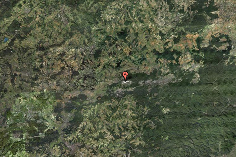
1. Baker Lake, Inuit territory in northern Canada 
The man, who identified himself as "Dr. Boylan", believes that the darkened area in this picture and in several other locations hides extraterrestrial beacons of aliens.
2. Ramstein Air Force Base, Germany

This NATO air base is the starting point for Operation Iraqi Freedom forces, and for this reason, it can certainly be a target for terrorist attacks. This may explain why this feature is partially cut from Google Maps.
3. Pacific Northwest, USA

What exactly are we not seeing in this photo? This place is located near the border of the states of Washington and Oregon. Enthusiasts personally examined this place and found nothing remarkable, except for the sinister appearance of the fence and the unmarked entrance.
4. Shazalombatta Oil Refinery, Hungary

This is one of the strangest examples of censorship in Google Maps - this place is simply painted over in green. The factory area has been removed, the buildings have been erased, and all you can see is regular grass.
5. Huis Ten Palace, Holland

It's hard to imagine that the Dutch royal family could be the prime target for a crazed terrorist, but the royal palace of Huis Ten is heavily blurred on Google Maps from any angle. (However, the surrounding area and trees can be seen with crystal clarity at close magnification.)
6. Unknown zone, Russia

No one knows what is hidden in this region. One of the opinions is that there is a “radar station or missile interception system” there, and some argue that the image of the surrounding area is pasted from another region of Russia.
7. Mobil Oil Corporation, Buffalo, New York, USA

Some criticize Buffalo-based Mobil for blurring images of its operations, saying that oil corporations are not of much interest to terrorists. On the other hand, we do not know what the terrorists themselves think.
8. North Korea

Everyone has heard of this country, which is part of the supposed "Axis of Evil", but very few have ever visited it. You won't see it on Google Maps either, as the entire country exists in the imagery, but without road markers, street names, or any other identifying details.
9. Reims Air Base, France

The reasons why this air force base is blocked from Google Maps are unknown.
10. Indian Point Power Plant, New York, USA

Many members of the United States government called for a shutdown of the Indian Point power plant. Environmental considerations aside, according to energy experts, the power plant is not strong enough to withstand an earthquake like the one that recently devastated Japan.
11. Volkel Air Base, Holland

It is rather amusing to see how this air base is grossly blurred on satellite images, however, WikiLeaks has published diplomatic correspondence that confirms the presence of nuclear warheads on the territory of this base.
12. HAARP, Gakona, Alaska, USA

HAARP (High Frequency Northern Lights Research Program) is one of the most controversial operations currently underway in the United States. Gakona, the site of research, and the ionosphere experiments there, are revered by some conspiracy theorists as the cause of everything from floods to earthquakes, but there is very little evidence for this.
13. Mazda Laguna Seca Raceway, Salinas, California, USA

This is one of the strangest examples of censorship on Google Maps: the Laguna Seca race track in Salinas, California. The strangest thing about this is the fact itself: this is an apparently harmless race track.
14. Babylon, Iraq

While the surrounding area is perfectly visible, the city of Babylon itself is blurred in the pictures. One can argue that this has something to do with the rebels there ...
15. Tantauco National Park, Chile

Why is this endangered species sanctuary completely cut out of Google Maps? Nobody knows.
16. The Hill, Elmira Correctional Facility, USA

This is the highest security prison in New York State. Perhaps, after the Attica prison riots and several incidents of uprisings and mass escapes around the world, the authorities may indeed be worried about the possibility of helicopter escapes.
17. House of Alexey Miller, Russia

According to Wikipedia, this place is the "private palace of the executive director of JSC Gazprom Alexei Miller." But why is he given preference over all other people? Maybe we're just not powerful enough to convince Google to cut out our homes from satellite imagery.
18. Colonel Sanders

This is the strangest fact from Google: Colonel Sanders, the face of the Kentucky Fried Chicken chain, does not appear in any of the Google Street View images. This is because, according to Google representatives, Sanders was a real person, and images of real people should be blurred in any pictures.
19. Faro Islands, Denmark

It is believed that in this zone there are some non-advertised military installations.
20. NATO Headquarters, Portugal

This shot would be the funniest if it didn't have such an ominous context. Whoever edited the image of NATO's Portuguese Headquarters simply copied another area of the earth's surface over the image of the building. Very strange.
21. Seabrook Nuclear Station, New Hampshire

The Seabrook Nuclear Power Plant is believed to be located in this northeastern United States.
22. Missile mine, Spain

According to one researcher, “At this site is a small building with what looks like a missile silo in the middle. What is strange is that this area is not blocked in Yahoo! Maps, but its image is not Google Maps.
23. Nuclear zone, France

We're not quite sure what "The Marcoule site of the Commissariat l'Energie Atomique" means, but we think "atomique" is the key here.
In contact with
Creative approach to work is a distinctive feature Google. Even on Google maps there are unusual and funny places, and many other interesting things.
Surprises await users in different parts of the world - a virtual walk through your own or neighboring city will turn into an amusing trip if you do it with cards from a popular search engine. Let's take a walk through several secret and interesting objects right now.
Wasteland Guardian
In the late fall of 2006, Lynn Hickox was browsing Google Maps and accidentally discovered unusual place. The woman was surprised by the similarity of the relief with the head of an Indian. It seemed that the aborigine was wearing a national headdress, and an earpiece was inserted into his ear.
In reality, the find turned out to be a geological formation in one of the provinces of Canada. Soils in this area are soft, clay. For a long time - at least a hundred years - they were subjected to winds, erosion, as a result of which the image appeared. What users mistake for a wired earphone is just the road to the oil rig and the oil well itself.
The dimensions of the "head" are impressive - its length and width are the same, they are 255 meters. Its coordinates are 50°00′38″ s. sh. 110°06′48″ W d.
heart lake
This is amazing place can only be viewed from a height or on Google maps. It is privately owned by the state of Ohio, next to Columbia Station.
The heart-shaped lake is filled with clear turquoise water. Romantics and lovers are happy to pay for flights and aerial photography to admire this beauty.

The owner of the land makes good money on such air excursions.
Galeshnyak
Since we are talking about hearts, we need to remember one more of the most interesting places on Google map, discovered in 2008. This is the Croatian island of Galesnjak, a place of pilgrimage for lovers from all over the world.
Why is it so attractive to couples? First of all, the shape of the heart. It is symbolic that an Internet user found this amazing place on the eve of For Lovers. The community immediately dubbed Galeshnyak "the island of love."

Until that moment, the uninhabited part of the land became the center of tourism. The local society took advantage of the situation by organizing engagements at the heart center. A Moscow couple was the first to celebrate their engagement here.
Sandy
Its shape resembles a black sausage, and this island became famous when scientists officially recognized it as non-existent. About everything in order. unknown island in pacific ocean discovered by the Australians. It was located in a northwesterly direction from New Caledonia and occupied an area of about 60 km2.
In 2012, a few months after the discovery of the new island, Google put it on their maps. And in November of the same year, a group of scientists went there to study Sandy in detail.

What was the surprise of scientists when they saw ocean waters instead of land. In the spring of the following year, Sandy Island was officially declared a "mistake" with the explanation that Australian travelers mistook a pumice accumulation for land.
blood red pond
Strange places on google maps do not always have official explanations. A good example is a bloody reservoir near the city of Sadr, in Iraq.
An unusual pond was discovered in 2007, its coordinates are 33.396157 ° N. sh. and 44.486926° E. e. There was no official explanation about the red water, but unofficial versions dozens were exaggerated.

The townsfolk said that local slaughterhouses poured the blood of animals into the reservoir, others explained the bloody hue by draining waste or bacteria living in the water. Over time, the redness disappeared - the water in the lake acquired a normal shade.
Labyrinth as an imprint
Anyone can see this amazing place if they come to British Brighton. In Hove City Park, there is a labyrinth designed like a fingerprint.

The walls of the building were made of limestone slabs in 2006. And Internet users found the labyrinth using Google maps.
german cross
Users noticed the swastika on Google maps in the same 2006. The building, whose shape resembles a German cross, is run by the US Navy.
Users were indignant at the similarity with fascist symbols and demanded clarification. The command of the Navy apologized for the unpleasant situation and explained that the similarities were discovered during the construction process.

A year later, work began on the installation of solar panels - in such a non-standard way, the owners decided to change the shape of the building.
overgrown ship
The ship was photographed by satellite near Sydney. The ship was moored at the mouth of the Parramatta River and overgrown with trees. Later, his story became known.

It turns out that the SS Ayrfield went on its maiden voyage in 1911. It was operated until 1972, after which it was decommissioned. Since then, SS Ayrfield has stood motionless on the river.
At American aircraft there is also a cemetery. Its coordinates are 32 08'59.96° N. sh. and 110 50’09.03° E. d., area - 10 km 2. The aircraft burial ground is located at the closed US military base "Davis-Monten".

The only way to see this place is to use the Google Earth service. Several thousand decommissioned aircraft and spaceships rest on the territory of the cemetery, there are legends among them. According to unofficial data, the total cost of scrap metal is estimated at $35 billion.
Desert circles
Two spirals emanate from the center. One spiral consists of cones, the farther from the center they are, the wider. The second spiral is recesses installed according to the same principle as the cones. From a height, the sculpture looks like circles. And everything would be fine if it were not for its location.

The sculpture is located in the Sahara - it was built by the employees of TO D.A.S.T. back in 1997. They expected that in a few years, under the influence of wind and erosion, nothing would remain at the site of the composition. More than 20 years have passed, and the strange circles are still in place today, they are perfectly visible from space.
Darfur lips, the kiss of the Earth - whatever they are called. Indeed, it is not every day that giant lips meet in the middle of the desert. Their proportions are close to ideal: length - 2.5 km, width - 1 km. And even the color from a height seems pink-red.

Lips are not an art object, but natural hills in the Darfur plateau in Sudan. You can only see and appreciate their perfect beauty from the air. On the Internet, unusual hills often become an occasion for jokes and witty comments.
Strange places on google maps
4 (80%) 3 voters1. Baker Lake, Inuit territory in northern Canada
The man, who identified himself as "Dr. Boylan", believes that the darkened area in this picture and in several other locations hides extraterrestrial beacons of aliens.
2. Ramstein Air Force Base, Germany
This NATO air base is the starting point for Operation Iraqi Freedom forces, and for this reason, it can certainly be a target for terrorist attacks. This may explain why this feature is partially cut from Google Maps.

3. Pacific Northwest, USA
What exactly are we not seeing in this photo? This place is located near the border of the states of Washington and Oregon. Enthusiasts personally examined this place and found nothing remarkable, except for the sinister appearance of the fence and the unmarked entrance.

4. Shazalombatta Oil Refinery, Hungary
This is one of the strangest examples of censorship in Google Maps - this place is simply painted over in green. The factory area has been removed, the buildings have been erased, and all you can see is regular grass.

5. Huis Ten Palace, Holland
It's hard to imagine that the Dutch royal family could be the prime target for a crazed terrorist, but the royal palace of Huis Ten is heavily blurred on Google Maps from any angle. (However, the surrounding area and trees can be seen with crystal clarity at close magnification.)

6. Unknown zone, Russia
No one knows what is hidden in this region. One of the opinions is that there is a “radar station or missile interception system” there, and some argue that the image of the surrounding area is pasted from another region of Russia.

7. Mobil Oil Corporation, Buffalo, New York, USA
Some criticize Buffalo-based Mobil for blurring images of its operations, saying that oil corporations are not of much interest to terrorists. On the other hand, we do not know what the terrorists themselves think.

8. North Korea
Everyone has heard of this country, which is part of the supposed "Axis of Evil", but very few have ever visited it. You won't see it on Google Maps either, as the entire country exists in the imagery, but without road markers, street names, or any other identifying details.
9. Reims Air Base, France
The reasons why this air force base is blocked from Google Maps are unknown.

10. Indian Point Power Plant, New York, USA
Many members of the United States government called for a shutdown of the Indian Point power plant. Environmental considerations aside, according to energy experts, the power plant is not strong enough to withstand an earthquake like the one that recently devastated Japan.

11. Volkel Air Base, Holland
It is rather amusing to see how this air base is grossly blurred on satellite images, however, WikiLeaks has published diplomatic correspondence that confirms the presence of nuclear warheads on the territory of this base.
12. HAARP, Gakona, Alaska, USA
HAARP (High Frequency Northern Lights Research Program) is one of the most controversial operations currently underway in the United States. Gakona, the site of research, and the ionosphere experiments there, are revered by some conspiracy theorists as the cause of everything from floods to earthquakes, but there is very little evidence for this.

13. Mazda Laguna Seca Raceway, Salinas, California, USA
This is one of the strangest examples of censorship on Google Maps: the Laguna Seca race track in Salinas, California. The strangest thing about this is the fact itself: this is an apparently harmless race track.

14. Babylon, Iraq
While the surrounding area is perfectly visible, the city of Babylon itself is blurred in the pictures. You can bet it has something to do with the local rebels...

15. Tantauco National Park, Chile
Why is this endangered species sanctuary completely cut out of Google Maps? Nobody knows.
16. The Hill, Elmira Correctional Facility, USA
This is the highest security prison in New York State. Perhaps, after the Attica prison riots and several incidents of uprisings and mass escapes around the world, the authorities may indeed be worried about the possibility of helicopter escapes.

17. House of Alexey Miller, Russia
According to Wikipedia, this place is the "private palace of the executive director of JSC Gazprom Alexei Miller." But why is he given preference over all other people? Maybe we're just not powerful enough to convince Google to cut out our homes from satellite imagery.

18. Colonel Sanders
This is the strangest fact from Google: Colonel Sanders, the face of the Kentucky Fried Chicken chain, does not appear in any of the Google Street View images. This is because, according to Google representatives, Sanders was a real person, and images of real people should be blurred in any pictures.

19. Faro Islands, Denmark
It is believed that in this zone there are some non-advertised military installations.

20. NATO Headquarters, Portugal
This shot would be the funniest if it didn't have such an ominous context. Whoever edited the picture of the Portuguese headquarters of NATO, they simply copied another area of the earth's surface over the image of the building. Very strange.

21. Seabrook Nuclear Station, New Hampshire
The Seabrook Nuclear Power Plant is believed to be located in this northeastern United States.

22. Missile mine, Spain
According to one researcher, “At this site is a small building with what looks like a missile silo in the middle. What is strange is that this area is not blocked in Yahoo! Maps, but its image is not Google Maps.

23. Nuclear zone, France
We're not quite sure what "The Marcoule site of the Commissariat l'Energie Atomique" means, but we think "atomique" is the key here.


