Volcano in Bali when it erupted. Volcanic eruption on the island of Bali: Is there a danger to Russian tourists
Bali is a unique island. This also applies to its geography: it is located in the area of the giant Pacific "ring of fire" - the junction of several lithospheric plates that form the continents on our planet.
Actually, this was reflected in its landscape: the island is intersected by an impressive mountain range that divides Bali into north and south. There are also external outlets for ejection of magma - the very two volcanoes that attract so many tourists: Agung and Batur.
Both volcanoes are considered active. But if Batur last showed signs of life in 2000, then Agung periodically reminds of itself with emissions within a radius of up to 4 km from the vent. There is no reason for tourists to worry about this: according to the conclusions of scientists, there are no prerequisites for larger eruptions. Given that the nearest resort villages are located almost 40 km from the dangerous point, the safety of vacationers is guaranteed.
At the same time, you need to understand that for the sake of your own safety, in no case should you climb the volcano on your own. You can only walk along the mountain routes with a guide.
Must-see volcanoes
As we have already mentioned, there are only two large volcanoes of interest to tourists here - Agung and Batur. Each has its own unique location and landscape, and climbing them promises to be one of the highlights of any traveler's life.

The top of this active volcano is located at an altitude of more than 3 thousand meters above sea level, and therefore the ascent will require decent physical fitness from you. However, on the way to the giant (the diameter of the crater is 520 × 375 m, the depth is about 200 m) you will have the opportunity to see many other iconic Balinese sights.
- Visit the city of Chandidasu. In it and its surroundings, you can see the unique temples of Tirta Ganga and Taman Ujung, combining national architectural motifs and elements of European-style buildings.
- Explore Goa Lavah (Bat Cave). It is located not far from the city, in it, according to legend, the patron saint of Bali lives - a huge snake Nag. The long tunnel gives a somewhat depressing impression with its darkness and gloomy atmosphere, but is one of the most popular places for tourists.
- Swim at the famous Blue Lagoon Beach, which is halfway to Agung.
Climbing the volcano itself will require you to have at least an entry-level athletic training. The lower half of the peak is covered with abundant greenery and palm groves, and it is quite easy to climb here. It is more difficult in the second half: the landscape becomes almost bare, monotonous, and besides, it is much colder there. Of course, there is something to try for - space views. But do not forget to bring warm clothes and a supply of water!
Of course, do not forget to take pictures of amazingly beautiful landscapes. "Mother Mountain", as the locals call it, is a wonderful panoramic platform for observing the island spread below.

More modest in size and altitude (only about 1700 m above sea level), Batur nevertheless gives more freedom to tourists. You probably already guessed why - it's safer here: the formidable giant has not made itself felt for almost 20 years.
Arriving at the volcano, you can choose from two options for spending time. The first is purely visual. I must say that it is quite suitable for lovers of large-scale panoramic landscapes - it is very convenient and comfortable to watch Batur from the observation deck of the village of Kintamani. In addition, next to the mountain peak is the volcanic lake of the same name - the landscape is simply fantastic.
The second option, although for the strong in spirit and body, is still more sparing than in the case of Agung, and provides more opportunities for tourist entertainment. For example, you can cook your breakfast right above the geysers of hot volcanic springs. By the way, boiled bananas are also very good.
The ascent to Batur takes about 3 hours - in total, it will take you about 7 hours for the whole journey plus a walk along the top. We recommend planning your ascent in such a way as to meet the dawn at the top - specially equipped observation platforms are very useful there.
Along the way, you can see the following sights.
- Lake Batur. Volcanic origin, it is the largest freshwater lake in Bali. Here you can also visit a small temple dedicated to the goddess of fertility and take a ride on a fishing boat.
- Hot volcanic springs. Thermal treatments in the open air - it's something! 4 km from Batur itself there are three stone baths carved into the rock, hot water in which comes from volcanic springs. Healing properties and just great relaxation are guaranteed! The ticket will cost 200 thousand rupees.
Volcanoes of Bali: how to get there?

To Angung: Jl. Gn. Agung Besakih (from the southwest) or through the cities of Klungkung and Chandidasu (there are bus flights from Kuta, where the famous beach and tourist centers are located).
To Batur: it is most convenient to go from the tourist villages of the Bukit Peninsula (Ubud or Denpasar). The whole journey will take about 1-1.5 hours by car or bus.
Upon arrival at the settlements, choose the way to get to the volcanoes. There are two such options.
- As part of an organized tour. It can be purchased at any tourist office for quite reasonable money - about $35-40 per person. An additional advantage of this climb format is that you will be provided with a really experienced guide, and a small snack will be prepared at the top.
- Alone with a guide. In the same Chandidas (Angung) or Kintamani (Batur) you can easily find an experienced person - or rather, he will find you himself. There is no fundamental difference between the tour package and the "handicraftsmen" - except that the group is selected a little less: 3-4 people. In addition, in terms of money, this is a good way to save $ 10-15. But are they worth it - you decide.
Important information

It concerns the most important thing - your safety! Experienced tourists recommend taking the following things with you.
- On your feet - soft sneakers: so you will not erase your feet, because it will take a very long time to walk.
- A mandatory supply of sweets - to quickly restore the strength that has gone in the process of lifting.
- Warm clothes. If below it is hot and humid, then above it is cold and piercing wind. Without a jacket, warm pants and a hat, you simply won't be able to get up.
- Do not forget to take a flashlight with you, and two are better at once: let one be a spare. Staying in the dark and getting lost halfway at night (those who meet the dawn leave exactly at night) is not a pleasant pleasure.
- A navigator or compass is required - if you know how to use it. Mark the place where you stopped or parked the rented scooter. By the way, do not forget that it should always be filled with gasoline.
How dangerous is a volcanic eruption in Bali (photo gallery)
At the most popular resort in Indonesia, the eruption of the Agung volcano continues. Some tourists leave the country, the authorities announced the evacuation of local residents. Photogallery DW.
-
ash cloud
Agung volcano eruption in Bali
Emissions of lava flows

Agung volcano eruption in Bali
The highest point in Bali
Agung volcano eruption in Bali
Paradise under the ashes

Agung volcano eruption in Bali
"Still Safe"

Agung volcano eruption in Bali
Airports closed
Agung volcano eruption in Bali

Agung volcano eruption in Bali
Magma and Ashes

Agung volcano eruption in Bali
Precautions in Bali
-
Agung volcano eruption in Bali
ash cloud
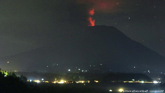
The eruption of Mount Agung in northeast Bali began over the weekend. As a result, nearby resorts and villages were covered with a thin layer of ash. Dark gray clouds over the top of the volcano were visible from the island's capital, the city of Denpasar, and even from the neighboring island of Lombok.
Agung volcano eruption in Bali
Emissions of lava flows
When night fell, a bright glow from the crater illuminated the ash cloud that rose 6,000 meters above the summit of Mount Agung. It began showing signs of activity as early as September, prompting local authorities to raise the volcano's alert status to emergency and evacuate 140,000 people living nearby. However, later, on October 29, the danger level was lowered.
Agung volcano eruption in Bali
The highest point in Bali
Volcano Agung with a height of 3142 meters is the highest point of the island. As a result of gas and ash emissions, the operation of two airports at once was stopped - on the island of Bali and on the neighboring island of Lombok.
Agung volcano eruption in Bali
Paradise under the ashes
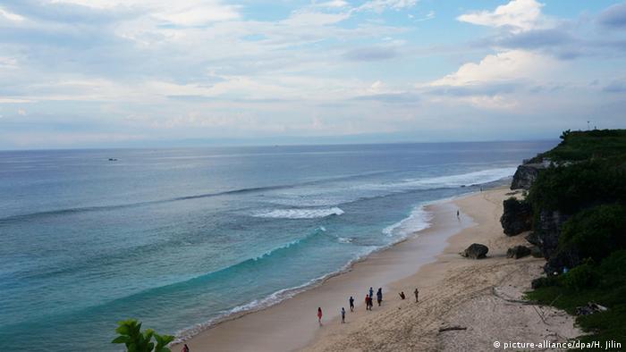
Bali is the main tourist center of Indonesia. Beautiful ocean beaches, temples and lush forests attract about 5 million tourists a year. But according to Made Sugiri, a spokesman for the local Mahagiri Panoramic hotel, the number of visitors has dwindled in recent months: "We're out of the danger zone, but like other resorts in the region, of course, the eruptions cause an outflow of tourists."
Agung volcano eruption in Bali
"Still Safe"
Indonesia's emergency management agency says Bali is "still safe" for tourists. Agung's emergency status remained at level 3 over the weekend, one point below the highest alert indicator, the agency said in a statement. At the same time, despite a number of eruptions, volcanic activity remains relatively stable.
Agung volcano eruption in Bali
Airports closed
Things were different with the status of air travel over the island - on Sunday, November 26, the level of danger here reached the highest - red - mark. Although many flights continued to operate, hundreds of people were stranded. As a result, the airport on the island of Lombok was closed first, and then the main international airport Ngurah Rai in Bali.
Agung volcano eruption in Bali
Exclusion zone around the volcano
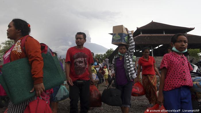
As a result of the latest lava eruptions, about 25,000 people left their homes. The authorities called on everyone inside the exclusion zone within a radius of 7.5 kilometers from the crater of the volcano to evacuate immediately. Mount Agung is one of over 120 active volcanoes in Indonesia. More than a thousand people became victims of its last major eruption, which happened in 1963.
Agung volcano eruption in Bali
Magma and Ashes
Volcanologists described Agung's renewed activity on November 25 as a phreatic explosion, that is, an eruption with smoke evaporation caused by heating and expansion of groundwater. On November 26, the authorities said that, judging by the ash settling, a magmatic eruption had already begun.
Agung volcano eruption in Bali
Precautions in Bali
"Mount Agung is still spewing ash, but we need to watch closely and be prepared for a more powerful, explosive eruption," warns Indonesian volcanologist Gede Suantika. Soldiers and police are handing out protective masks to people in nearby villages and resorts.
Fabulous Bali attracts many tourists not only with tropical nature and original culture, there are two famous active volcanoes Batur (Gung Batur) and Agung, as well as a dozen sleeping and extinct ones. A journey to these picturesque peaks will turn into a real adventure filled with emotions, vivid impressions and even a share of extreme sports. Do you feel the spirit of a pioneer in yourself and are not afraid of the hardships of ascent? Then forward to the heights!
How "mountain-mother" is translated from the local Agung dialect . This volcano is the highest point on the island. The following figures will help to assess its scale:
- height - 3142 m (according to other sources 3014 m);
- the size of the crater in diameter is 375x520 m;
- The depth of the crater is about 200 m.
The Balinese have a beautiful legend about the origin of the volcano. It is believed that Bali used to be a flat island where happy people and animals lived. Seeing such prosperity, the Gods themselves decided to settle in this heavenly place and erected Agung, from where they could observe the life of the island and the good deeds of its inhabitants. The sacred bird Garuda took the most hardworking Balinese to the top.
Today, on the bare peak of Agung, you will not meet the Gods and Garuda, but it is worth climbing there to see the most beautiful sunrise in the world.

Climbing Agung
Climbing the volcano should only be accompanied by an experienced guide, and you need to choose routes in accordance with your physical fitness. The most popular route will start from the western slope from the temple of Pura Besakih at 23:00 and take 5-7 hours, ending with a meeting of the dawn at the very top.
The second most popular path runs from the village of Selat. Hiking will last only 3-4 hours and will be limited to a height of 2860 m, but you will see the crater of the volcano.
Today, the volcano behaves like a good boy, but the inhabitants of the island remember well the devastating eruption of 1963, when a number of villages were swept away by lava and about one and a half thousand people died. In the fall of 2017, Agung again made itself felt, it was necessary to evacuate everyone who was in close proximity to the rebellious mountain and stop air travel. Fortunately, no one was hurt. In 2018, Mount Agung is closed for climbing.
Volcano Batur
This volcano is located in the eastern part of Bali on a caldera with an area of 368 sq. km. A caldera is a pit that was formed as a result of the collapse of a volcano. It is believed that more than 300 thousand years ago, after a powerful eruption, the walls of the ancient volcano became thinner, and it collapsed, forming a depression where Batur is located.
The lake at the foot of the volcano is also a caldera. It is considered the world's largest crater reservoir and the locals say that it is guarded by the water goddess Devi Danu. In addition to the "divine guard" there is the usual guard. Swimming here is strictly prohibited, you have to admire at a distance.

Right at the foot you can see several villages, nicknamed "lake stars". People who dared to live in such close proximity to an active volcano are driven, by no means, by fearlessness, but by calculation. Each eruption makes the soil even more fertile, the lake is full of fish, and there is also a handicraft production of souvenirs from volcanic tufa. Well, how to leave such a "bread" place ?!
Information about Batur:
- the height of the volcano is 1717 m;
- cone height - 686 m;
- the number of craters is 3.
Since the 19th century, 22 eruptions of various strengths have occurred on Batur. Once, the Balinese even sewed a huge sarong and wrapped a volcano around it to appease the gods. Did the sarong help or rich offerings, but since the 60s the volcano has really not presented unpleasant surprises (small ash emissions and seismic activity do not count).
Climbing Batur
Traveling to the volcano is like walking. The ascent does not require physical preparation and will take only 2 hours. The guides plan the trip in such a way that tourists get to the top at dawn. From here, a magnificent panorama of Bali opens in the bright dawn rays.

At the top there is an observation deck with cafes and shops where you can have a bite to eat and relax. By the way, not only you rise, but also the prices - “at the top” the cost of water, tea and other things is much more expensive than at the foot.
The fun that will certainly be shown to you is cooking steamed food from the crater faults. The temperature is enough to boil an egg or fry bananas.
Any ascent to the summit, whether it be difficult to Agung or easier to Batur, requires preparation. Therefore, we offer you some useful tips:
- it is recommended to conquer the peaks of volcanoes in the “dry” period, and this is June-November;
- stock up on a headlamp, warm clothes (at night the winds on the slopes are quite cold);
- I recommend wearing comfortable non-slip shoes;
- in the backpack there should be water with the calculation of 2-3 liters per person;
- It is worth starting such an event well rested and well-rested.
Are volcanoes dangerous in Bali?
Despite the fact that Batur and Agung volcanoes are considered active, they do not pose a serious danger to tourists.
Of course, the history of the island eloquently testifies to unexpected manifestations of activity, but today specialists are very carefully watching the volcanoes, fixing all the changes: temperature increase, seismic tremors, unusual behavior of flora and fauna. On the alert and rescue services that are ready to help and evacuate people at the slightest danger.
So a little courage, adventurism, excitement and unforgettable peaks of volcanoes will submit to you, or maybe you will be conquered by them? Steinbeck said: “People do not create travel, but travel creates people.” And in Bali you will definitely feel it.
This is the second eruption of Agung stratovolcano in the past week. The first happened on November 21 - then the smoke from the volcano rose to a height of 700 meters from the crater. The Disaster Management Agency rated the volcano's activity level as fourth out of four possible. On Sunday, a column of smoke from the crater rose to a height of four thousand meters, and therefore the eruption was assigned the highest (red) level of threat to air traffic.
First, the Indonesian authorities closed the airport of Lombok Island after the second eruption. And then the international airport in Bali was closed for 18 hours, SBS News reported.
However, the event itself is not extraordinary for a region that was, in fact, formed as a result of volcanic activity.
According to former RIA Novosti correspondent Mikhail Tsyganov, who has lived in Bali for a long time, there are about 600 volcanoes in Indonesia, of which about 130 are active. “I am 25 kilometers from the crater of the volcano. You can see it differently depending on the weather. Usually it is visible from morning to late at night. Yesterday I saw it perfectly. Today the top was tightened,” he said.
No panic
According to Tsyganov, local residents, and most of the tourists, perceive what is happening calmly, do not panic. "Panic" is observed mainly in the media, especially on television, which loves bright pictures, and among tourists who have not yet fully figured out where they are," he explained.