Cape of Goodwill. Cape of Good Hope
The Cape of Good Hope on the map of Africa can be found in the south of the continent. He is not iconic geographical point noted in textbooks and nautical sailing guides. But the discovery of a strip of land located on the way from the Atlantic to the Indian Ocean was as dramatic as the voyages of Magellan or.
In contact with
Geographical component of the discovery
Now this is the territory of the sovereign state of South Africa, the city of Cape Town is located near the Cape of Good Hope, and the coordinates are 34°21′32″ S. w. 18°28′21″ E. etc., can be easily found in geographical publications.
From Lisbon to Cape Town modern ship arrives in a few days, and many centuries ago, during geographical discoveries, the journey lasted 10 long months...
Colonial expansion of Portugal
By the end of the 15th century, Portugal had become a strong maritime power. The kingdom managed to avoid feudal strife and conflicts with church authorities, and the country's resources were directed toward maritime expansion into the Atlantic.
This course was forced. The greatest benefit trade was represented in two directions:
- with India and Central Asia;
- with England and the German states.
Mediterranean trade was taken over by Venetian merchants and Genoese, sea communications of the Baltic and North Sea The Hanseatic League was firmly in control, and the young state had no other point of application of strength.
Prince Henry, later nicknamed the Navigator (although he himself did not lead any expeditions), modernized the shipbuilding industry, ensured the functioning of the personnel training system, and provided the Portuguese naval forces with advanced technical equipment.
Slave trade
In the middle of the 15th century, the kingdom's fleet made sea voyages to the Atlantic, where they were discovered and annexed to the Portuguese crown. Azores, Madeira and Cape Verde Islands. These actions served as a good school of navigation and behavior in extreme, for Europeans, tropical climate conditions. Using the captured islands as a base for the fleet, Henry the Navigator sent one expedition after another to the African shores.
The ships sailed further and further south. As they advanced, fortresses and naval bases were founded, and a hunt was conducted for blacks, who were actively traded by Lisbon merchants. The income from the slave trade was enormous. In 1482, the Portuguese captured the territory in the Gulf of Guinea, which became the possession of the king. This place was called Jorgio da Mina (Mine of St. George), or Mina for short.
Already by 1485, the Congo region had been explored, and Diogo Can (the one who opened the pre-feudal state formation in the basin of this river for trade) reached the South West Africa around 20 degrees south latitude.
Expedition to the Far South
In the summer of 1487, King John II equipped another expedition to the African shores: in the direction of the coastal zone where the Cape of Good Hope is located. It included two military ships armed with cannons and a transport ship with supplies. The ships were small - with a displacement of approximately 50 tons and a simple sailing rig.
The event was led by Bartolomeu Dias (Dias), an experienced sailor who had previously participated in the exploration of the Atlantic coast of Africa.
Diaz's expedition set off along the established routes, through the Cape Verde Islands to Fort St. George. Having replenished supplies, the small flotilla moved further south. The ships crossed and reached the coast of modern Namibia.
The desert, rocky terrain was a stark contrast to Guinea and Equatorial Africa.
Attention! The navigators installed a padran (a sign in the form of a pillar on which the coat of arms of Portugal, the name of the king and the details of the discoverer are carved).
Moving south, in the direction where the Cape of Good Hope is located, they reached a coordinate of 33 degrees south latitude.
These lands were of no interest to the colonialists. They were poorly populated, and the Portuguese needed “live goods.” The natives of the Gulf of Guinea and the Congo had already felt the iron grip of the Europeans. Unable to withstand their weapons, the population abandoned the coastal areas, going inland. In search of “ebony” (as Christian merchants called black slaves), ships went south.
Opening of the sea route to India
In the Gulf of St. Helena, where Cape Town is located today (a port near the Cape of Good Hope), the flotilla was overtaken by a storm. The storm carried the ships into the open; the transport ship fell behind even earlier. When the wind died down, Diaz turned east and led the flotilla in that direction for several days. Africa still did not show up. Bartolomeu Diaz decided that its southern tip had been passed, which is why he ordered to turn north.
On February 3, 1488, the sailors finally saw the tops of the mountains, and soon the green coast appeared. Having landed, the Portuguese skirmished with the natives, one of whom was shot by Diaz himself with a crossbow.
Continuing to move east, the Portuguese reached a wide bay, the shore of which gently curved to the northeast. Diaz realized that he had entered the Indian Ocean.
Attention! It is not known for certain what further plans the sailors had.
Presumably, they could have faced the following tasks:
- Exploration of the coast beyond the South Tropic.
- Identification of places where slave trade is possible.
- Paving the way for maritime trade with India.

But the crews of both ships, tired of the long journey, demanded to return to Lisbon.
Fearing a riot, Diaz ordered a turn.
Walking along the coast, the ships came across a long strip of land protruding far into the sea.
Bartolomeo Diaz named it Cape Tormentozu (Stormy), remembering the storm that almost sank his ships here.
Landing at the Cape of Good Hope
The exact date when the Cape of Good Hope was discovered is unknown. This probably happened in February 1488. The expedition set off on its return journey, reaching its native shores only in December.
Attention! In Lisbon, John II received a report on the results of the voyage and ordered to rename Cape Tormentozo to the Cape of Good Hope.
The results of the long voyage really gave the kingdom hope that the route to India would be open where the Cape of Good Hope was located, and Portugal would have considerable advantages in ocean trade.
There is no evidence that Bartolomeu Dias received any reward from the monarch.
The only thing the sailor who was the first to reach the Cape of Good Hope could console himself with was a sign on a deserted piece of land, where under the coat of arms his name was carved in stone: the third padran, during the voyage, was installed on the cape.
Dias Bartolomeu
The Amazing Cape of Good Hope
Conclusion
For more than five centuries, the cape was controlled by Portuguese merchants, Dutch settlers (Boers), and British colonialists. In 1961, the colony (Union of South Africa) gained independence. And 30 years later, the English influence was finally put to rest by Nelson Mandela. For a long time, the cape bore the honorary title of the southernmost point of the “black”, but then it passed to Cape Agulhas, which is located a little further in the southeast.
This is interesting! History of Travel: Ages of Discovery
Cape of Good Hope (South Africa) - detailed description, location, reviews, photos and videos.
- Last minute tours in South Africa
- Tours for May Worldwide
Previous photo Next photo


The Cape of Good Hope represented the hopes of the Portuguese who were looking for a route to India in the 15th century. It was originally called the Cape of Storms, but King John II was superstitious and therefore decided to rename this point on the Cape Peninsula. Today the Cape of Good Hope is one of the important strategic sites of the African continent. He once helped ships get from Europe to Far East, now remains popular for its scenery, which attracts millions of tourists.
How to get there
You can get to the Cape of Good Hope, located on the Cape Peninsula, from Cape Town. The journey by car will take about four hours. Time will pass unnoticed, because along the way you will encounter a very beautiful area: a savannah where ostriches, antelopes, baboons and other animals roam, mountains, a nature reserve.
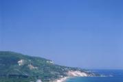
The Cape of Good Hope is the most southwestern point of Africa. It is impossible to make a mistake, since this fact is confirmed by both scientists and an inscription with exact coordinates installed on the site in front of the cape. But the Cape Peninsula at this point reaches its southernmost point and, going to the north, ends with Cape Point.
Reserve
The road to the Cape of Good Hope inevitably leads through the reserve of the same name. It is characterized by lush vegetation, which interferes with movement if traveling on foot. The highest density of plants is on the Cape Peninsula. It is almost impossible to get through here; you need a car. The area of the reserve is more than 7 thousand hectares. Here you can find plants that cannot be found in other parts of the world.
The vegetation and fauna of the reserve match its uniqueness in the fact that penguins live here next to monkeys, cheetahs and antelopes. Yes, yes, it’s the penguins that we are used to seeing only in the coldest parts of the planet. The fact is that they were able to swim to Africa from Antarctica and settled here.
Previously, penguins felt almost like the owners of the reserve and calmly went to their neighbors in search of food. But then, apparently, when other animals got tired of such anarchy, penguins received a separate territory. It's called Boulders Beach.
The reserve is open every day, seven days a week. In summer it receives guests until 18:00, and in winter - until 17:00 local time.
Cape of Good Hope and surroundings
Beaches
The Cape of Good Hope has beaches where you can relax and sunbathe. People come here both in large groups and with the whole family. There are even places on the beach where lovers can retire and hide from prying eyes.
The swimming season usually lasts from September to May. During this period, the weather is sunny, so you can safely go here to get a tan. On other days there is nothing special to catch on the beach.
Lighthouse
The lighthouse is one of the main attractions of the Cape of Good Hope. It was built in 1860 and its height is 240 meters above sea level. In South Africa this is the most high lighthouse. Unfortunately, it does not work, because one day it could not help the Portuguese ship - the lighthouse was covered with clouds, and the ship, which did not see the signal, landed on the rocks.
But at the lighthouse at an altitude of 200 meters there is an observation deck. You can climb it on foot or by cable car. Next to the lighthouse there is a restaurant and a souvenir shop.
The site offers a wonderful view of two oceans at once: the Indian and the Atlantic. The waters of these oceans wash both sides of the cape. If you look closely, you can see that the oceans are different in color. The waves run very quickly onto the rocks and break against them, leaving traces of white foam.
Excursions
Typically, excursions to the Cape of Good Hope include a visit to the reserve, as well as the shore with a penguin haven. We'll tell you about a few more places that are worth seeing. On the coast of False Bay, or “False Bay,” a winding road is laid through the mountains. Along it you can get to the town of Simon's Town, where the British Royal Navy was previously based.
The coast of the Cape of Good Hope itself has its own characteristics. For example, on the western side the climate is milder, there are beaches, sandy shores, and an atmosphere of peace and tranquility. In the east it is warmer, but strong winds blow, which make it difficult to swim and enjoy the scenery. On this part of the coast, not everyone takes the risk of swimming; tourists prefer to just sit on the shore and breathe the ocean air.
The island of fur seals is of great interest to travelers. Its area is only 4 square kilometers - small for an island, and it leads its turbulent history since the 17th century. The fact is that for three centuries there was a prison here, military base and a hospital. And it was on this island that freedom fighter and future South African President Nelson Mandela served his sentence. In 1999, the island became a UNESCO World Heritage Site. A museum has opened here, telling about the history of the country. Tourists can visit the prison yard and cells.
The Cape of Good Hope is a popular attraction for tourists traveling to Cape Town. South Africa. This beautiful place with unpredictable weather, baboons and adorable penguins playing in the ocean. Here you can fully enjoy the stunning scenery and wealth of wildlife.
Description and location
A hill on the Cape Peninsula, located on the world map near Cape Town. He is mistakenly considered the most southern point continent and the place where the Atlantic and Indian oceans meet. In fact, the tip is located at Cape Agulhas (Agulhas), located on the South African Garden Road, 200 km from the capital of South Africa.
Cold Bengal Current west coast and the warm Agulhas Current converge at the foot of one of Africa's top attractions, which, along with nearby Cape Point, offers spectacular scenery.

The summit is located 70 km from Cape Town. You can get there from the city by car in an hour and a half. Legend has it that the ghosts of the Flying Dutchman's crew haunt the Cape and its waters, although visiting tourists are much more likely to see penguins, antelope and perhaps a right whale.
Geographical coordinates Cape: 54°31′08″ north latitude and 42°04′15″ east longitude. Altitude: 93 m
origin of name

The historical fact of why the Cape of Good Hope is called that is quite interesting. It dates back to the time of exploration in the 15th century, when the European powers Spain and Portugal sent sailors to unexplored places in search of wealth. The first European to see and discover the cape was the Portuguese explorer Bartolomeo Dias, who was looking for the southern borders of the African continent. The date of the expedition he led is considered to be 1486.
According to some historical sources, Dias called his discovery "Cape of Storms" (Cabo das Tormentas), but later changed it to the current name of the cape (Cabo da Boa Esperança), so named at the suggestion of King John II of Portugal because of the trade opportunities it brought this place. According to other sources, Dias himself came up with this name. He was from a family of hereditary sailors. His older brothers, moving south along the coast of West Africa, discovered Capes Bojador and Green.
History of the Cape
Nine years passed before Vasco da Gama, another Portuguese sailor, also attempted to travel to the southern tip of Africa on his way to India. The sailors met people from the Khoya tribe, and several members of Vasco da Gama's crew were injured in the clash with them. Other important facts in the history of this area are:

- Although the Portuguese were the first to travel the Cape, they were not seriously interested in southern Africa. They were wary of the indigenous population, and the weather was sometimes treacherous and dangerous.
- Some early Portuguese navigators chose not to sail around this area. Moreover, in terms of trade, South Africa had very little to offer: gold had not yet been discovered, and the land seemed desolate and unpromising.
- In June 1580, almost 100 years later, Sir Francis Drake sailed past the cape. He was in trip around the world commissioned by Elizabeth I of England. The weather was calm and the scenery serene. This view inspired Sir Francis Drake to say the following words: “This cape is the grandest thing and the fairest cape that we have seen in all the circumference of the earth.” More British expeditions followed, and soon other European countries followed in their footsteps.
- In the first half of the 17th century, the English and Dutch used the route, which was supposed to go around the cape, for trade purposes. Danish and French ships stopped to replenish water supplies and stock up on fresh food.
- Although English, French and Dutch East India companies toyed with the idea of establishing a base on the Cape in the 17th century, it was the Dutch who finally took the first step.
On December 31, 1687, a group of Huguenots was sent to the Cape from the Netherlands. They fled France to escape religious persecution. The Dutch East India Company needed skilled farmers in the Cape, and the Dutch government saw an opportunity for the Huguenots by sending them there.

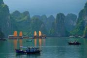
Cape of Good Hope plays an important role in the history of South Africa as stopping point for merchant ships sailing between Europe and the European colonies in the east. Initially, Europeans exchanged local residents for food and water, but on April 6, 1652, the Dutch East India Company, under the leadership of merchant Jan van Riebeeck, established a small supply station in a sheltered bay beyond the Cape Peninsula, forming the first European settlement in the region.
On January 19, 1806, Great Britain occupied extreme point peninsula. It was ceded to Great Britain in the Anglo-Dutch Treaty of 1814 and was henceforth administered as Cape Colony.
Today, the small station that provided refreshments to weary sailors has grown into the bustling city of Cape Town.
Vegetable world
The Cape Peninsula is one of eight protected areas in the region jointly recognized by UNESCO as a World Heritage for wealth flora. Although the 553,000-hectare Cape flower region represents only 0.5% of Africa's area, it contains almost 20% of the continent's plants. Fynbos, or "fine bush", is the most common category of plants found here, and many species are unique to the peninsula.
The cape is part National Park Mesa, and park rangers can be seen working to remove invasive species such as wattle, pine and blue gum that threaten the survival of native plants.
wild nature
The peninsula is rich wildlife, especially birds. Its shores are inhabited by the gannet, the African black oyster hunter and 4 species of cormorants. But the most famous feathered inhabitants are the penguins at Boulders Beach. Tourists can get an up-close look at one of the few colonies on the mainland at False Bay. There are special paths here that will lead you through the natural habitat of penguins, and if you visit this place between February and August, you can also see fluffy chicks.

Cape mountain zebra is occasionally found in these areas. But more common inhabitants are baboons, several species of antelope and the small, furry dassie, the elephant's closest relative. You can also watch whales and dolphins here.
Classes and activities
One of the main attractions of South Africa is a narrow peninsula overlooking the ocean. But such a location implies the presence of wind and unpredictable weather. However, the landscape that opens to visitors will not leave anyone indifferent:

- The coastline meets a backdrop of clouds with occasional glimpses of sun to create a dramatic landscape. While here, you can watch the zebras wandering around. Moreover, this perfect place for whale watching from June to November.
- You should climb the lighthouse to see best views to the cape There are 3 ways to get to the top. Along coastline There is a path with long stone stairs. This route offers the best views of the coast. From the parking lot there is a road all the way to the top. The climb is quite easy and not very strenuous. For those who do not want or are unable to walk, there is the Flying Dutchman funicular, which will take you to observation deck in 3 minutes for a small fee.
- A trip along the Cape Peninsula is one of the favorite additions to tourist route in Cape Town. The highlights of a day trip are the southernmost points of the Cape, and the stunning sea cliffs and ocean views will make tourists feel like they're on the edge of the earth.
Best places
Muizenberg Beach. Muizenberg is a beach suburb of Cape Town known for its white sandy shore and the very colorful houses that decorate it. Warm waters The Indian Ocean is an added bonus and attracts surfers to this place.

Simon's Town and Boulders Beach. Simon's Town is a historic and charming naval town on the shores of False Bay, and Boulders Beach is famous for its colony of African penguins. Thousands of individuals go about their daily business: cleaning their wings, looking after their children. The Boulders Beach walk is done on a wooden plank. If you want to get closer to the penguins, you need to go further along sand dunes to Foxy Beach, but be aware that penguins can be aggressive and if you get too close you can experience how sharp their beaks are.
Cape Point. This peak can be reached by driving just over 1 km east of the main headland. This is where the Flying Dutchman funicular is located, offering views of the lighthouse.
Chapman's Peak Drive. There's nothing like the windswept Atlantic coastline, and Chapman Peak provides... ocean road the most breathtaking view. This toll highway is carved into the rock and features nearly vertical climbs and blind turns. It starts in the fishing village of Hout Bay and runs to Chapman's Point before ending in Noordhoek. The ocean views are incredibly beautiful along the entire route, but the best are from Chapman's Point - the most high point roads.
Let's say right away that the Cape of Good Hope is not the southernmost point of Africa. But he is definitely the most famous in all of it south coast.
In the era of the Great Geographical Discoveries (from the end of the 15th century), ships, skirting the continent, changed course for the first time, turning east towards the Indian Ocean, right here. Therefore, people considered this cape to be the southernmost. Since then, science has stepped forward and clarified that in fact Cape Agulhas, located 150 km to the southeast, should be considered the southern point of the mainland. And the Cape of Good Hope bears the honorary title of the most southwestern point of the African continent.
Cape of Good Hope on the map
- Geographic coordinates -34.357890, 18.475453
- The distance from the capital of South Africa, Pretoria, is approximately 1340 km
- Distance to nearest international airport Cape Town about 45km
An interesting fact is that there are 3 capitals in South Africa. Pretoria is the official capital of the state. But the parliament is in Cape Town, and the supreme court is in Bloemfontein. And these cities are also called capitals. This is explained as follows: at the beginning of its formation, South Africa was a confederation, which included 3 territories - the Republic of South Africa (Pretoria), the possessions of Britain (Cape Town), and a country with a very exotic name Orange Free State (Bloemfontein). When South Africa was formed, it was decided to distribute authorities evenly across these cities.
Let us return to the Cape of Good Hope. Initially it was called the Cape of Storms. And for good reason.
The history of the name is as follows:
Europeans were looking for a sea route to India. For this purpose, in the middle of the last millennium, an expedition set out from Portugal. And in 1488, Captain Bartolomeo Dias rounded this cape for the first time. But these guys didn’t manage to get to India, because the team got tired and rebelled. Dias was forced to turn back. On the way back, a storm raged in the area of the cape. The ship and its crew were pretty battered. The sailor did not invent an original name, calling the rocky ledge simply Cape of Storms. A little later, King Juan II of Portugal decided to rename it the Cape of Good Hope, rightly believing that such a name would not only not scare off other sailors, but would also give them hope for a quick completion of the journey.
The king's initiative paid off. Already in 1497, Vasco Da Gama paved the way from the Old World to India. The expedition was successful, and since then the name Cape of Good Hope has been firmly attached to this rocky outcrop. Many sailors began to use this route.
Yes, of course, the souls of the sailors were filled with hope when approaching this cape, because more than half of the journey was behind them. Joy spread across the faces of the team. But no matter how amazing and bewitching the Cape of Good Hope attracts attention, it is quite dangerous for sailors. Storms and storms are quite normal for these places. To this day, about three dozen sunken ships can be seen in the surrounding waters.
To facilitate navigation, a lighthouse 238 meters high above sea level was built in 1857. But it turned out to be too high, and sometimes clouds and fog completely covered it.
 Old lighthouse Cape of Good Hope
 After another shipwreck in 1911, a decision was made to move the lighthouse. From 1913 to 1919, the lighthouse was built in a different place and not so high. The new lighthouse rises only 87 meters above sea level. But it can be seen from a distance of more than 60 km. This is the most powerful lighthouse on the entire southern coast of Africa. Since then, the sea route in the area of the cape has become much safer.
 New Cape of Good Hope Lighthouse
 There is an interesting misunderstanding. In fact, ships passing from the Atlantic to Indian Ocean, round Cape Point, located a little further. But it is the Cape of Good Hope that enjoys worldwide fame.
Behind Cape Point is a cozy Falsbay Bay, similar to Hawaiian Hanauma Bay. There is beautiful beach, washed by the warm current of the Indian Ocean.
Excellent beaches on the border of two oceans, stunning views of the surrounding area, and the diversity of flora and fauna in the Cape of Good Hope area attract a huge number of tourists.
Cape of Good Hope in photographs


The Cape of Good Hope is perhaps the most famous cape in Africa. Where is the Cape good hope? On the territory of the Republic of South Africa, or more precisely, on the Cape Peninsula.
First mentions
A lot of swear words were said by the sailors about this place that was disastrous for them. The history of navigation tells of the exorbitant efforts that many sailors and pioneers had to make to overcome the ocean currents, rounding this cape.
Who discovered the Cape of Good Hope? This question cannot be answered unambiguously. Now, based on information from historical sources, we can say with confidence that the first to visit this place were the inhabitants of Ancient Egypt back in 500 BC.
Egyptian sea voyage
This happened during the reign of Pharaoh Necho II, who set out to return economic stability to his state. To do this, it was necessary to find a way to deliver Egyptian goods to Europe, that is, find a workaround there. A delegation of hired Phoenicians was sent to east side Africa, where sailors hoped to find workarounds. This journey lasted for three whole years, and several times the Phoenicians interrupted it by landing on Earth to grow something edible, since the supplies were not designed for such a long period. Africa turned out to be so vast. The Cape of Good Hope probably became their landing site, and then the travelers rounded it. Upon their return, the discouraged Phoenicians said that they were shocked by how one day “the sun suddenly appeared on the north side,” therefore, they crossed the equator.
The idea of finding a workaround was unsuccessful, and further travel was not profitable. Expenses exceeded income, and for more than two thousand years no one attempted to sail here.
Bartolomeo Dias: the one who discovered the Cape of Good Hope
At the end of the 15th century, many wealthy Europeans were ready to pay any money for pleasant and expensive luxury items from distant India. However, the path there was blocked by vast Muslim lands, because the followers of Muhammad’s teachings did not strive to improve relations with Europe and normalize trade relations. Consequently, it was necessary to look for another route - by sea.
The first attempts to find it were made by the Portuguese. Juan II sent an expedition to find a bypass route to the country of elephants. At the head of the expedition was who, possessing perseverance and endurance, nevertheless swam with his team to the Cape of Good Hope. But what work! Hellish currents, hostile attitude of the natives. Members of his crew mutinied on ships many times. They demanded to return to their homeland, because most of them had lost hope of finding a way to India. To the question “Where is the Cape of Good Hope?” None of the sailors, including Bartolomeo Dias, could answer. Since these were the first people to swim to it, they could not know its exact location relative to the continents. And it didn’t have a name either. Then B. Dias, impressed by the torment that this place brought them, called it “Cape of Storms.” This is how the Cape of Good Hope was discovered. The year in which this event occurred (1488) marked the beginning of the history of this mysterious and unusual place.

Return of the Portuguese sailors
Another surge of discontent among Dias’ team led to the expedition turning back. The sailors flatly refused to continue the journey, which seemed endless to them. They saw no point in further attempts to go to the East, because it was as if the elements themselves were against them and sent numerous storms. But, despite the fact that the sailors did not reach the coast of India, King Juan II was pleased with the results of the expedition, considering the “reconnaissance” successful. The only thing he didn’t like was the scary name given to the cape by Bartolomeo Dias. The king considered that the cape needed a different name, which would inspire travelers that the cape was not the main obstacle on the way to India, but the first step leading closer to it. Therefore he gave this place the name "Cape of Good Hope". Geographic coordinates: latitude: -34.358056; longitude: 18.471944
The Journey of Vasco da Gama
A few years later, another Portuguese, Vasco da Gama, was the first to sail along the route of the first expedition and made a corresponding note in his logbook. He wrote that as a result of lengthy and skillful maneuvers, his ship passed the Cape of Good Hope. The lyrical name really became the key to the luck of the Portuguese. The discovery of the Cape of Good Hope by Vasco da Gama dates back to 1497. This navigator reached the shores of India, which he reported to the king upon his return. Thus, Vasco da Gama fulfilled the main goal of his journey. But the development of the territory of South Africa was not included in it.

Discovery of the Cape of Good Hope by the Dutch as a shipping point
The founding of the port city of Cape Town (from the English “city on the cape”) is the merit of the Dutch. It was they who discovered the Cape of Good Hope as the first transshipment point between Rotterdam and India. It was here that the sick were treated and the ships of the Dutch East India were supplied with water and food supplies. The local native population initially welcomed the guests cordially. But in the late 60s of the 17th century, when Europeans began to intensively destroy Cape Town, the natives began to be forced out of their native lands and forced into slavery. On this basis, long bloody conflicts began.
Disputes over the Cape
The British knew who discovered the Cape of Good Hope and who founded Cape Town. But this did not stop them from taking away southern Africa from the Dutch in 1795. Now this territory began to be called the “colonial province of the Cape of Good Hope.” Among the population were the descendants of the first colonists - the Boers, which means “peasants” in Dutch. The new order caused them great dissatisfaction, and then, overcoming the resistance of the Zulus on their way, they moved to the north of the continent.
Liberation from the colonial regime
Until the end of the 19th century, the Boers lived separately, and the territory inhabited by them received the unspoken name “Boer republics”. But when it was discovered that these lands contained large deposits of diamonds and gold, the British again turned their attention to the rebellious Boers. From 1899 to 1902, the brutal Anglo-Boer Wars continued, as a result of which Great Britain nevertheless captured the territory of the Boer republics. Now all of South Africa (including the Cape of Good Hope) was under the control of the British.
Only more than half a century later, in 1961, the period of long-term colonial dependence was completed. Now this territory was called as follows: Republic of South Africa.
The Legend of the Flying Dutchman
This legend is the most intriguing and famous story Cape of Good Hope. She has a great many variations. Sometimes the names of the main characters in it differ, but the plot in any case has the same meaning. It was in this place that the captain of one of the Dutch ships was cursed. His reputation was, to put it mildly, not very good. He was known as a foul-mouthed and blasphemous man. This captain's name was Van Stratten. He always had a whip in his hands with a lead plaque at the end, in case anyone got caught. The backs of many sailors were forever covered with scars from savage beatings with this whip. Van Stratten's ships often carried African slaves, who died by the dozens along the way. Dead bodies were usually thrown overboard. That is why there were sharks as escorts near the ships of this captain, waiting for the next “handout”. Well-fed and satisfied, they delighted the cruel captain with their presence; he jokingly called them “my little fish.” On one of the voyages, the ships were caught in a severe storm. Just then they were rounding the Cape of Good Hope, the coordinates showed exactly this, because it was impossible to see anything in such bad weather. All the sailors begged the captain to turn back in order to wait out the rampant elements.

It is not difficult to guess that Van Stratten responded with a nasty curse. He said: “No way! I'll still swim! I will not retreat even if the world ends. I will even give my soul to the devil, but I will survive this storm.” It was at that moment that the heavenly gates opened, and the voice of the Almighty was heard: “You said it! Now swim!” The devil took the captain's soul. Since then, Van Stratten's ship has been drifting restless and doomed off the coast of the cape. All the sailors and the foul-mouthed captain himself are now doomed to eternal life, to immortality in the expanses of water, without being able to land on shore. Meeting other ships, immortal seafarers strive to convey their letters to relatives who have long since died. Taking these letters is a very bad omen. If you do this, then the curse passes to the compassionate assistant.
Attractions
One of the most famous attractions is considered national reserve, whose name coincides with the name of the cape. It is part of Table Mountain ( national park"Table Mountain")
The colony rare species penguins, which are called spectacled or black-footed penguins; Chacma bear baboon colony.
From geographical objects the most visited is the one that marks the southern tip of Africa.
South African astronomical observatory; the port city of Cape Town, where you can visit the Victoria and Alfred Waterfront and the Two Oceans Aquarium; territory Botanical Garden Kirstenbosch, founded in 1913; the Castle of Good Hope estate, which is the oldest building in South Africa; South African National Gallery.
The Cape of Good Hope is famous for these places. Photos of some of them are given below.

Cape of Good Hope as the personification of human hopes
The name of the cape truly inspires hope. And even people who despaired of their troubles and misfortunes, having been in this mysterious place, begin to believe in the best. The Cape of Good Hope becomes a guiding star for those people who have never been there, illuminating the lives of sick children with its name.

The Cape of Good Hope SD is a community of parents all over the world whose children are suffering. They unite in the fight for the health and full life of their children, giving each other hope for the best.

So, the answer to the question “Who discovered the Cape of Good Hope” is the navigator Bartolomeo Dias, who first set foot on the land of this truly magical place. It was he and his three small ships who first rounded this cape. Nowadays, many myths, stunning nature and attractions attract many tourists to the Cape of Good Hope.